Toktrapport fra Mareano leg 3 2023. Målet for toktet var MAREANO-kartlegging av områder i ytre Oslofjord, men også å redde mistet utstyr eid av HI (videorigg) og FFI (skjellramme). Toktet var meget påvirket av dårlig vær, og måtte ved flere anledninger utføre alternativ kartlegging utenfor de opprinnelige interesseområdene grunnet dette. Et annet mål for toktet var å samle inn data med AUV samtidig som konvensjonell toktvirksomhet pågikk.
Mareano leg 3 2023
Rapportserie:
Toktrapport 2024-9
ISSN: 1503-6294
Publisert: 25.04.2024
Prosjektnr: 15312-03
Forskningsgruppeleder(e):
Sigurd Heiberg Espeland (Bunnsamfunn)
Godkjent av:
Forskningsdirektør(er):
Geir Lasse Taranger
Programleder(e):
Frode Vikebø
English summary
Sammendrag
Cruise Report from Mareano Leg 3, 2023. The objective of the cruise was MAREANO mapping of areas in the outer Oslofjord adn Skagerrak, but also to recover lost equipment owned by the Institute of Marine Research (video rig) and the Norwegian Defence Research Establishment (shellframe). The cruise was greatly affected by bad weather, necessitating alternative mapping areas outside the pre-planned areas of interest on several occasions due to this. Another aim of the cruise was to collect data with an Autonomous Underwater Vehicle (AUV) while conventional cruise activities were ongoing.
1 - Abbreviations
The following Abbreviations are use throughout this report:
AUV : Autonomous Underwater Vehicle – here it is the Kongsberg Munin +.
CT : Conductivity and Temperature (but not Depth as is normal) – the AUV CT sensor does not collect pressure information that is converted into depth as standard, but it does have an altimeter/depth sensor as part of that navigation system so this data is also available.
CTD : Conductivity, Temperature and Depth sampling rosette
FFI: Forsvarets forskningsinstitutt (Norwegian Defence Research Establishment)
FOH: Forsvarets operative hovedkvarter (Norwegian Joint Headquarters)
HF: Hardanger fjord
HI : Havforskningsinstituttet or the Institute of Marine Research as it is called in English.
MBE : MultiBeam Echosounder
NGU : Norsk Geologiske Undersøkelse or the Norwegian Geological Survey as it is called in English.
SVO : Særlig Verdiful Område – translates to “Especially Valuable Area” and is a Norwegian management region that currently has no protection measures but indicates an area of particular ecological value.
2 - Aims
-
Recover the Chimera video rig that was lost during Mareano leg 2 (approximately 7 nm east of Tromøya.
-
Achieved
-
-
Assist FFI in recovering a shell frame from a dumping ground for munitions (post WWII) in the Norwegian Trench.
-
Achieved
-
-
Sample (physically and using video) Isidella corals along the slope south of Egersund for studies and gene sequencing.
-
Achieved
-
-
Perform full station physical sampling simultaneously with AUV dive.
-
Achieved
-
-
Gain experience with the placement and use of different equipment for cruises equipped with AUV, ROV and physical sampling gear.
-
Achieved
-
-
Perform various tests related to improving data quality with the AUV Munin+ and evaluate the position accuracy and navigational skills.
-
Partly achieved
-
-
Video sample areas in Skagerrak that cannot be mapped with conventional Mareano sampling due to challenging terrains and current conditions (which requires ROV).
-
Partly achieved
-
-
Obtain shallow core samples of bottom sedients both inside and outside of intensively trawled areas for studies of carbon storage in sediments.
-
Partly achieved
-
-
Complete three previously planned video stations that have not been sufficiently surveyed.
-
Deferred due to weather
-
-
Map trawl tracks and investigate the consequences of intensive trawling for seabed conditions, including carbon storage capacity in sediments.
-
Deferred due to weather
-
3 - Areas
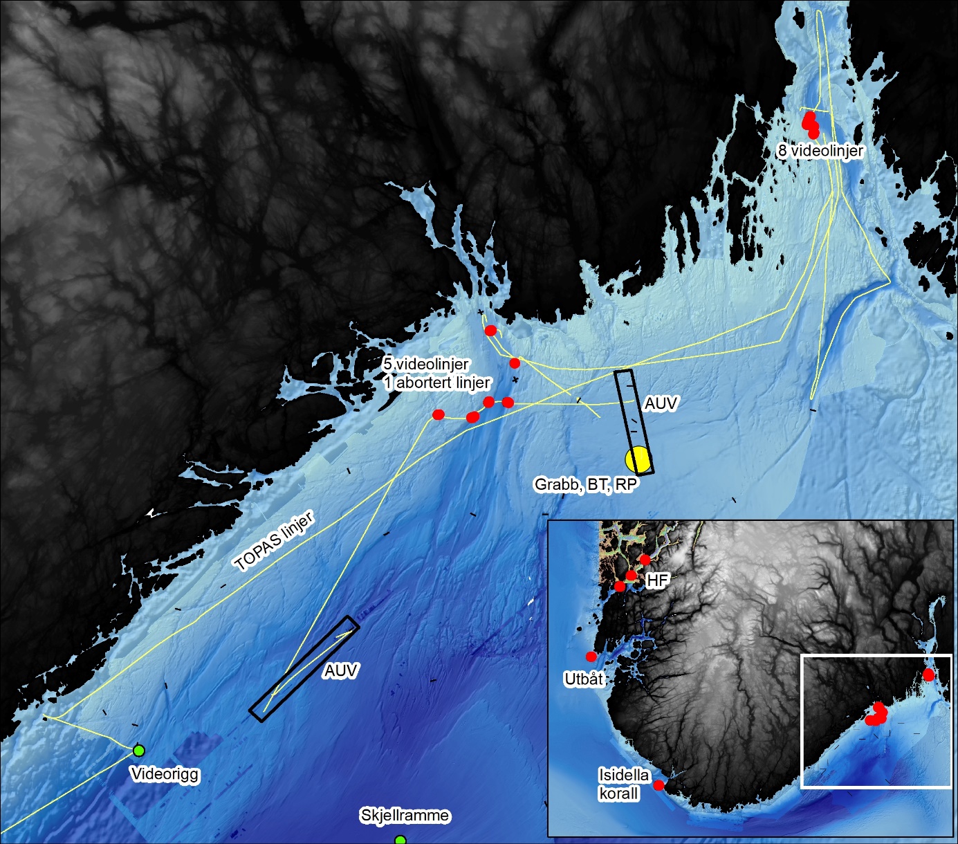
The cruise was focused on areas with steep or challenging terrain in Skagerrak, where video sampling using a camera rig is not possible. A planning meeting at NGUs offices in Trondheim where we had access to restricted high-resolution bathymetry was carried out before the cruise in order to plan all targeted stations based on 1) terrain and 2) seabed substrate. This resulted in a total of 31 planned stations of priority as well as 18 backup stations of lower priority. We also planned four areas for AUV mapping, and two back-up areas in secluded areas close to land in case of challenging weather conditions. We had applied (and received permission) from FOH for declassification of seabed data in these areas before the cruise. In addition to the main interest area in Skagerrak, we had planned ROV dives south-west of Karmøy on the recently discovered wreck of a WWII U-boat and in the Isidella hot-spot outside Lindesnes. Due to extreme weather conditions we had to plan a new set of video lines inside the Hardanger fjord. We did not have a suitable declassified area inside the fjord, so AUV missions were not possible to conduct and were therefore not planned. The video stations in the fjord are marked on the inset map (HF).
4 - People
| Name | Surname | Organisation | Role |
| Valerie | Bellec | NGU | Geologist (video, sampling) |
| Pål | Buhl-Mortensen | HI | Biologist (video, sampling) |
| Reidulv | Bøe | NGU | Geologist (video, sampling) |
| Lene | Christensen | HI | Biologist (video, sampling) + AUV |
| Martin | Dahl | HI | Instrument technician |
| Eyvind | Ernstsen | HI | ROV pilot |
| Barbro Taraldset | Haugland | HI | Biologist (video, sampling) |
| Kyrre | Heldal Kartveit | HI | Cruise leader |
| Josefina | Johansson | HI | Biologist (video, sampling) |
| Yngve | Klungseth Johansen | HI | Biologist (video, sampling) |
| Aivo | Lepland | NGU | Geologist (video, sampling) |
| Björn | Löfqvist | Ægir | ROV pilot |
| Jörn Patrick | Meyer | HI | AUV pilot |
| Leif Johan | Ohnstad | HI | AUV pilot |
| Nils | Piechaud | HI | Scientist - AUV |
| William | Skjold | HI | ROV pilot |
| Silje | Smith-Johnsen | HI | Data management |
| Terje | Thorsnes | NGU | Geologist (video, sampling) + AUV |
5 - Activities
Priority
-
Recover the video rig Chimera (1)
-
Finish the two last (grts) video-stations in Skagerrak
-
ROV video stations (and physical sampling) in Skagerrak
-
Survey trawl marks (AUV + ROV-dives)
-
Carbon storage sediment sampling
-
Map modelled coral reef with AUV
-
Sample Isidella south of Egersund
-
Aid FFI in recovery of mussel rig
-
Sample a full station simultaneously with AUV-dive
Lower Priority
-
Video stations in the southern part of the Norwegian North Sea i SN
-
Sample additional full stations in Skagerrak
6 - Collected Data
Information regarding the data collected is shown in the following figures, as well as the overview map (figure 1). More details for each station are available in the day by day overview appendix, on the mareano webpage, or can be given upon request.
| # | Units | Gear | Short description |
| 21 | Stations | Ægir6000 | ROV video lines for mapping biology and geology |
| 3 | Stations | CTD | CTD stations for sound profiles for utilizing AUV with sidescan sonar and multibeam |
| 810 | n.miles | Topas | Topas lines for geoogical and sediment mapping. |
| 7 | Stations | Small VV grab | 7 grabs with small sediment grab for sampling and environmental analysis. |
| 2 | Haul | Beam trawl | Two beam trawl hauls at Mareano full-station for collecting benthic fauna. One successful, as the net was not sealed properly on the first try. |
| 1 | Haul | Epibenthic sled | One epibenthic sled haul for collecting benthic fauna. |
| 20 | Samples | Ægir 6000 | 20 push core samples for marine geology. |
| 20 | Samples | Ægir 6000 | 20 samples of benthic fauna with ROV manipulator. |
| Equipment | Refstation No | Sample No | Station No | Latitude | Longitude | Bottom Depth | Datetime |
| CTD | 0 | 472 | 1 | 5826.304 | 917.1973 | 428.88 | 09.10.2023 06:11 |
| CTD | 0 | 473 | 1 | 5852.423 | 1011.151 | 182.35 | 10.10.2023 06:01 |
| CTD | 0 | 474 | 1 | 5915.826 | 1033.589 | 192.47 | 11.10.2023 06:00 |
| Video | 3284 | 3446 | 1 | 5905.737 | 508.5402 | 169.25 | 08.10.2023 01:19 |
| Small VV grab | 3284 | 81 | 1 | 5905.762 | 508.5948 | 167.53 | 08.10.2023 02:43 |
| Video | 3366 | 3447 | 1 | 5850.101 | 941.5575 | 126.62 | 09.10.2023 19:38 |
| Bioboks | 3366 | 3447 | 1 | 5850.106 | 941.552 | 138.165 | 09.10.2023 20:01 |
| Bioboks | 3366 | 3447 | 2 | 5850.106 | 941.552 | 138.165 | 09.10.2023 20:01 |
| Video | 3367 | 3448 | 1 | 5850.111 | 946.8958 | 305.13 | 09.10.2023 22:43 |
| Pushcorer | 3367 | 3448 | 1 | 5850.116 | 946.888 | 304.996 | 09.10.2023 23:04 |
| Pushcorer | 3367 | 3448 | 2 | 5850.116 | 946.888 | 304.996 | 09.10.2023 23:04 |
| Bioboks | 3367 | 3448 | 1 | 5850.09 | 946.6935 | 211.105 | 09.10.2023 23:44 |
| Bioboks | 3367 | 3448 | 3 | 5850.09 | 946.6935 | 211.105 | 09.10.2023 23:44 |
| Bioboks | 3367 | 3448 | 2 | 5850.09 | 946.6935 | 211.105 | 09.10.2023 23:44 |
| Video | 3368 | 3449 | 1 | 5851.346 | 949.0112 | 257.16 | 10.10.2023 01:09 |
| Pushcorer | 3368 | 3449 | 1 | 5851.349 | 948.9837 | 255.673 | 10.10.2023 01:24 |
| Video | 3369 | 3450 | 1 | 5851.514 | 951.7833 | 372.03 | 10.10.2023 03:02 |
| Pushcorer | 3369 | 3450 | 1 | 5851.51 | 951.7725 | 405.553 | 10.10.2023 03:13 |
| Video | 3370 | 3453 | 1 | 5915.308 | 1034.265 | 318.92 | 11.10.2023 16:34 |
| Pushcorer | 3370 | 3453 | 1 | 5915.313 | 1034.253 | 325.715 | 11.10.2023 16:52 |
| Video | 3370 | 3454 | 1 | 5915.207 | 1034.173 | 226.09 | 11.10.2023 17:24 |
| Video | 3370 | 3455 | 1 | 5915.113 | 1034.098 | 166.77 | 11.10.2023 17:53 |
| Pushcorer | 3370 | 3455 | 1 | 5915.131 | 1034.115 | 175.676 | 11.10.2023 18:08 |
| Video | 3370 | 3456 | 1 | 5915.029 | 1034.044 | 124.94 | 11.10.2023 18:31 |
| Pushcorer | 3370 | 3456 | 1 | 5915.045 | 1034.049 | 137.66 | 11.10.2023 18:44 |
| Bioboks | 3370 | 3456 | 6 | 5914.996 | 1034.019 | 105.306 | 11.10.2023 19:02 |
| Bioboks | 3370 | 3456 | 2 | 5914.954 | 1033.995 | 88.22 | 11.10.2023 19:28 |
| Bioboks | 3370 | 3456 | 5 | 5914.954 | 1033.995 | 88.22 | 11.10.2023 19:28 |
| Bioboks | 3370 | 3456 | 1 | 5914.954 | 1033.995 | 88.22 | 11.10.2023 19:28 |
| Bioboks | 3370 | 3456 | 7 | 5914.954 | 1033.995 | 88.273 | 11.10.2023 19:32 |
| Bioboks | 3370 | 3456 | 4 | 5914.954 | 1033.996 | 87.96 | 11.10.2023 19:34 |
| Bioboks | 3370 | 3456 | 3 | 5914.954 | 1033.996 | 87.96 | 11.10.2023 19:34 |
| Beamtrawl | 3371 | 14 | 1 | 5847.769 | 1011.206 | 207.49 | 10.10.2023 08:59 |
| Beamtrawl | 3371 | 15 | 1 | 5847.833 | 1011.563 | 201.69 | 10.10.2023 10:03 |
| RP-sledge | 3371 | 28 | 1 | 5847.961 | 1012.783 | 192.76 | 10.10.2023 10:48 |
| Small VV grab | 3371 | 82 | 1 | 5847.894 | 1012.308 | 192.09 | 10.10.2023 12:51 |
| Small VV grab | 3371 | 83 | 1 | 5847.893 | 1012.309 | 192.01 | 10.10.2023 13:20 |
| Small VV grab | 3371 | 84 | 1 | 5847.893 | 1012.309 | 191.89 | 10.10.2023 13:48 |
| Small VV grab | 3371 | 85 | 1 | 5847.893 | 1012.309 | 192.04 | 10.10.2023 14:14 |
| Boxcorer | 3371 | 86 | 1 | 5847.894 | 1012.308 | 191.79 | 10.10.2023 14:49 |
| Small VV grab | 3371 | 86 | 1 | 5847.894 | 1012.308 | 191.79 | 10.10.2023 14:49 |
| Small VV grab | 3371 | 87 | 1 | 5847.894 | 1012.308 | 191.87 | 10.10.2023 15:18 |
| Video | 3372 | 3451 | 1 | 5854.571 | 952.4534 | 254.67 | 10.10.2023 18:58 |
| Bioboks | 3372 | 3451 | 1 | 5854.567 | 952.4639 | 247.999 | 10.10.2023 19:10 |
| Pushcorer | 3372 | 3451 | 1 | 5854.566 | 952.4579 | 247.785 | 10.10.2023 19:14 |
| Video | 3373 | 3452 | 1 | 5856.898 | 948.394 | 248.07 | 10.10.2023 21:46 |
| Pushcorer | 3373 | 3452 | 1 | 5856.917 | 948.3619 | 239.467 | 10.10.2023 22:07 |
| Pushcorer | 3373 | 3452 | 2 | 5856.92 | 948.405 | 239.938 | 10.10.2023 22:16 |
| Pushcorer | 3373 | 3452 | 3 | 5856.936 | 948.4551 | 240.063 | 10.10.2023 22:41 |
| Pushcorer | 3373 | 3452 | 4 | 5856.936 | 948.4551 | 240.063 | 10.10.2023 22:41 |
| Pushcorer | 3373 | 3452 | 5 | 5856.951 | 948.5154 | 240.028 | 10.10.2023 22:54 |
| Video | 3374 | 3457 | 1 | 5914.852 | 1033.959 | 161.02 | 11.10.2023 21:03 |
| Pushcorer | 3374 | 3457 | 1 | 5914.858 | 1033.948 | 152.671 | 11.10.2023 21:22 |
| Video | 3374 | 3458 | 1 | 5914.75 | 1033.894 | 132.65 | 11.10.2023 21:52 |
| Bioboks | 3374 | 3458 | 1 | 5914.723 | 1033.857 | 115.409 | 11.10.2023 22:06 |
| Video | 3375 | 3459 | 1 | 5914.577 | 1034.655 | 139.21 | 11.10.2023 23:02 |
| Pushcorer | 3375 | 3459 | 1 | 5914.592 | 1034.651 | 140.463 | 11.10.2023 23:10 |
| Bioboks | 3375 | 3459 | 1 | 5914.546 | 1034.868 | 156.839 | 11.10.2023 23:42 |
| Video | 3376 | 3460 | 1 | 5914.058 | 1034.996 | 145.07 | 12.10.2023 00:22 |
| Pushcorer | 3376 | 3460 | 1 | 5914.059 | 1034.974 | 137.73 | 12.10.2023 00:32 |
| Video | 3377 | 3461 | 1 | 5807.045 | 628.5348 | 344.71 | 13.10.2023 12:26 |
| Bioboks | 3377 | 3461 | 1 | 5807.054 | 628.5278 | 338.003 | 13.10.2023 12:38 |
| Bioboks | 3377 | 3461 | 2 | 5807.055 | 628.5266 | 337.954 | 13.10.2023 12:45 |
| Pushcorer | 3377 | 3461 | 1 | 5807.055 | 628.5261 | 337.963 | 13.10.2023 12:47 |
| Bioboks | 3377 | 3461 | 3 | 5807.13 | 628.6779 | 319.125 | 13.10.2023 13:19 |
| Video | 3377 | 3462 | 1 | 5807.124 | 628.6871 | 326.96 | 13.10.2023 13:22 |
| Bioboks | 3377 | 3462 | 1 | 5807.238 | 628.8977 | 298.098 | 13.10.2023 13:58 |
| Video | 3378 | 3463 | 1 | 5942.077 | 525.6296 | 172.31 | 14.10.2023 06:42 |
| Video | 3379 | 3464 | 1 | 5948.478 | 535.7652 | 178.56 | 14.10.2023 10:12 |
| Pushcorer | 3379 | 3464 | 1 | 5948.478 | 535.5481 | 164.649 | 14.10.2023 11:08 |
| Bioboks | 3379 | 3464 | 1 | 5948.478 | 535.5482 | 164.747 | 14.10.2023 11:10 |
| Video | 3380 | 3465 | 1 | 5956.957 | 547.1453 | 414.39 | 14.10.2023 13:47 |
| Pushcorer | 3380 | 3465 | 1 | 5956.966 | 547.1535 | 414.409 | 14.10.2023 13:54 |
| Video | 3381 | 3466 | 1 | 6020.063 | 615.7488 | 857.68 | 14.10.2023 18:19 |
| Pushcorer | 3381 | 3466 | 1 | 6020.06 | 615.7546 | 846.454 | 14.10.2023 18:47 |
7 - Challenges
We had some major difficulties with weather conditions on the cruise. Waves of op to 12 meters in the North Sea made us withdraw into the fjords for the better part of the cruise. As we had some prioritized operations that demanded fair weather conditions we had to use the small weather windows to complete these at the expense of other activities. We sent an inquiry to end the cruise early due to the demanding conditions, but due to a major surge if ships going in to Bergen Havn and weekend approaching it was not possible to de-mobilise until the pre-planned date we decided to make the best of it and spent the last days surveying the Hardanger fjord.
7.1 - ROV
The Ægir6000 was surprisingly susceptible to wave action and, not least, current conditions. We experienced that a current strength of as little as 2 knots made diving with the ROV challenging. Based on this, we would recommend bringing the TMS if Ægir is to be used on expeditions during the winter season
7.2 - AUV
As somewhat feared in advance, the weather windows for AUV collection were few and short, and as a result, we were not able to use the vessel nearly as much as we wanted. This resulted in two successful dives in the Skagerrak that collected data of apparently good quality. Launch and recovery went well despite challenging weather conditions, which we view as positive.
7.3 - Deck space during the cruise
In one of the Skagerrak's AUV areas, a full station was conducted in parallel with the AUV dive. The deck space for processing samples was effectively resolved in consultation with the trawl boss and bridge. Cleaning and sorting stations on the port side of the trawl deck were well suited for MAREANO's samples. A small “breakwater” (molo) was placed in front of the grate on the stern of the vessel, which worked OK under the prevailing weather conditions, but in rougher seas, the grate should be able to be closed off with a solid plate or the breakwater significantly heightened to secure valuable samples during processing. We envision conducting physical sampling in AUV areas simultaneously where the AUV is operational on upcoming voyages.
8 - Appendix 1 – AUV dive plans
This cruise aimed at carrying out tests on the AUV function and particularly how the different acoustic instruments potentially interfered with each other and how much the AUV drifted throughout the dive by covering the same points at the beginning and end of the dive and with different instrument switched on.
Two divers were carried out and went relatively well and collected good data that will enable the intended tests. However, the weather did not allow further dives after the day 2 of the cruise so only 2 dives took place instead of the 6 intended.
8.1 - Dive 1:
This first dive took place at the a relatively flat 400m deep area in the southwesternmost declassified zone. It aimed at collecting acoustic data over an area where the presence of pockmarks and the general topographic setting led to the suspicion that it contained a lot of mud which could store vast amount of carbon.
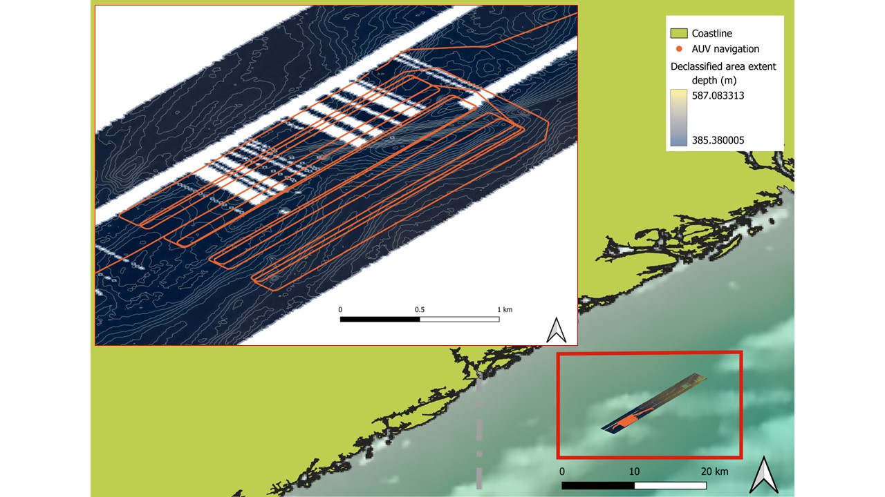
The AUV used the EM2040 Multibeam while flying at 70m in a grid pattern to provide full bathymetric coverage of the area at <1m resolution.
The Hisas sounder was also used in a grid pattern flying at 20m from the seabed to provide full coverage of the same area at high resolution
Finally a last line was carried out where the vehicle went back over the terrain it had previously surveyed and, particularly, at a noticeable feature that stood out and would be easily identifiable in the resulting surface thus acting as an ‘anchor’. This repetition will enable a precise measurement of the drift in AUV positioning throughout the mission by calculating the distance between the locations of the anchor feature in both MB lines that went over it. At the last point before the AUV started its ascend, the distance between the internal navigation and the navlab processed navigation was 4.85m. This less than 5m drift over 6 hours is considered low.
8.1.1 - Dive Plan 1
# Kongsberg Maritime AUV Mission Plan
# Saved 2023-10-09 14:01:19 by hugin
#:Tag Depth Alt DMo Latitude Longitude Course GMo Speed SMo Dur Dist Flags
# Speed up
:speed 0.0 30.0 D - - 234.0 H 2.30 S 30 - EMPowerOn
: = = = - - = = = = 30 -
# NB: Remember to set Safe 20m and Crit 10m distance in Startup parameters!
: = = = - - = = = = 30 -
# Are we waiting enough for payload to boot?
: = = = - - = = = = 1 - EMPowerOn
: = = = - - = = = = 1 - SASPowerOn
: = = = - - = = = = 1 - ETPowerOn
: = = = - - = = = = 1 -
: = = = - - = = = = 1 -
: = = = - - = = = = 1 -
: = = = - - = = = = 1 -
: = = = - - = = = = 1 -
: = = = - - = = = = 10 -
: 0.0 = = - - = = = = 1 -
# Start dykk til 50m for aa sjekke at alt er ok, Jump here to repeat dive
:dive 50.0 = = - - = = = = 180 -
: = = = - - = = = = 1 -
: 50.0 = = - - = = = = 180 -
# Jump from here to repeat dive, health check here
:health = = = - - = = 2.00 S 20 -
: = = = - - = = = = 1 -
# Submerged, vehicle configuration
:config = = = - - = = = = 1 - RollCtrlOn
: = = = - - = = = = 1 - EM400Int
: = = = - - = = = = 1 - Auto
: = = = - - = = = = 1 -
: = = = - - = = = = 1 -
: = = = - - = = = = 1 -
# Descent to working depth (100 m / 3 min), Activate HiSAS
:descent 300.0 70.0 D - - = = = = 720 - EMOn
: 400.0 70.0 T - - = = = = 180 -
# Lead-in to Survey Pattern
:leadin = = = 58:27.9368N 009:21.4817E (234) = = = - - Auto
:leadin = = = 58:27.8909N 009:21.4018E (222) = = = (57) (115)
: = = = 58:27.8475N 009:21.3591E (207) = = = (45) (91)
:mbline01 = = = 58:26.8607N 009:19.6104E (223) = = = (1250) (2500)
:mbturn = = = 58:26.7903N 009:19.7559E (133) = = = (96) (193)
:mbline02 = = = 58:27.7771N 009:21.5047E (043) = = = (1250) (2500)
:mbturn = = = 58:27.7067N 009:21.6505E (133) = = = (96) (193)
:mbline03 = = = 58:26.7199N 009:19.9013E (223) = = = (1250) (2501)
:mbturn = = = 58:26.6494N 009:20.0468E (133) = = = (96) (193)
:mbline04 = = = 58:27.6362N 009:21.7961E (043) = = = (1250) (2501)
:mbturn = = = 58:27.5658N 009:21.9418E (133) = = = (96) (193)
:mbline05 = = = 58:26.5790N 009:20.1922E (223) = = = (1250) (2501)
:mbturn = = = 58:26.5085N 009:20.3377E (133) = = = (96) (193)
:mbline06 = = = 58:27.4954N 009:22.0874E (043) = = = (1250) (2501)
:mbturn = = = 58:27.4249N 009:22.2331E (133) = = = (96) (193)
:mbline07 = = = 58:26.4381N 009:20.4831E (223) = = = (1250) (2501)
:mbturn = = = 58:26.3677N 009:20.6285E (133) = = = (96) (193) SASMode1
:mbline08 = = = 58:27.3545N 009:22.3787E (043) = = = (1250) (2501) SASHighPower
:em_stop = = = 58:27.4676N 009:22.4003E (006) = = = (105) (211) EMOff
# HISAS - set depth and altitude
:hisas_st 400.0 = = 58:27.5095N 009:22.3245E (317) = = = (53) (107) SASOn
: = = = 58:27.5476N 009:22.2459E (313) = = = (52) (104) CritHeight6
: = = = 58:27.5817N 009:22.1826E (316) = = = (44) (88) SafeDist10
: = 20.0 = 58:27.8194N 009:21.6825E (312) = = = (328) (657)
# Lead-in to Survey Pattern
:leadin = = = 58:27.7928N 009:21.4667E (257) = = = (107) (216) ETOn
:l01 = = = 58:26.8000N 009:19.7455E (222) = = = (1245) (2490)
: = = = 58:26.7692N 009:19.8103E (132) = = = (42) (85)
:l02 = = = 58:27.7620N 009:21.5316E (042) = = = (1245) (2490)
: = = = 58:27.6787N 009:21.7072E (132) = = = (115) (230)
:l03 = = = 58:26.6858N 009:19.9858E (222) = = = (1245) (2491)
: = = = 58:26.6551N 009:20.0506E (132) = = = (42) (85)
:l04 = = = 58:27.6479N 009:21.7721E (042) = = = (1245) (2491)
: = = = 58:27.5647N 009:21.9476E (132) = = = (115) (230)
:l05 = = = 58:26.5718N 009:20.2261E (222) = = = (1245) (2491)
: = = = 58:26.5410N 009:20.2909E (132) = = = (42) (85)
:l06 = = = 58:27.5339N 009:22.0125E (042) = = = (1245) (2491)
: = = = 58:27.4506N 009:22.1880E (132) = = = (115) (230)
:l07 = = = 58:26.4577N 009:20.4664E (222) = = = (1245) (2491)
: = = = 58:26.4269N 009:20.5312E (132) = = = (42) (85)
:l08 = = = 58:27.4198N 009:22.2529E (042) = = = (1245) (2491)
# MB check
: = = = - - = = = = 1 - SASOff
: 400.0 70.0 = 58:27.6712N 009:21.9254E (042) = = = 1 - EMOn
:em_leadi 400.0 70.0 = 58:27.7069N 009:21.6522E (284) = = = (136) (274)
:mb_check = = = 58:26.6496N 009:19.7760E (223) = = = (1340) (2681)
: = = = 58:26.0763N 009:18.7772E (222) = = = (720) (1442) Ascent
8.2 - Dive 2
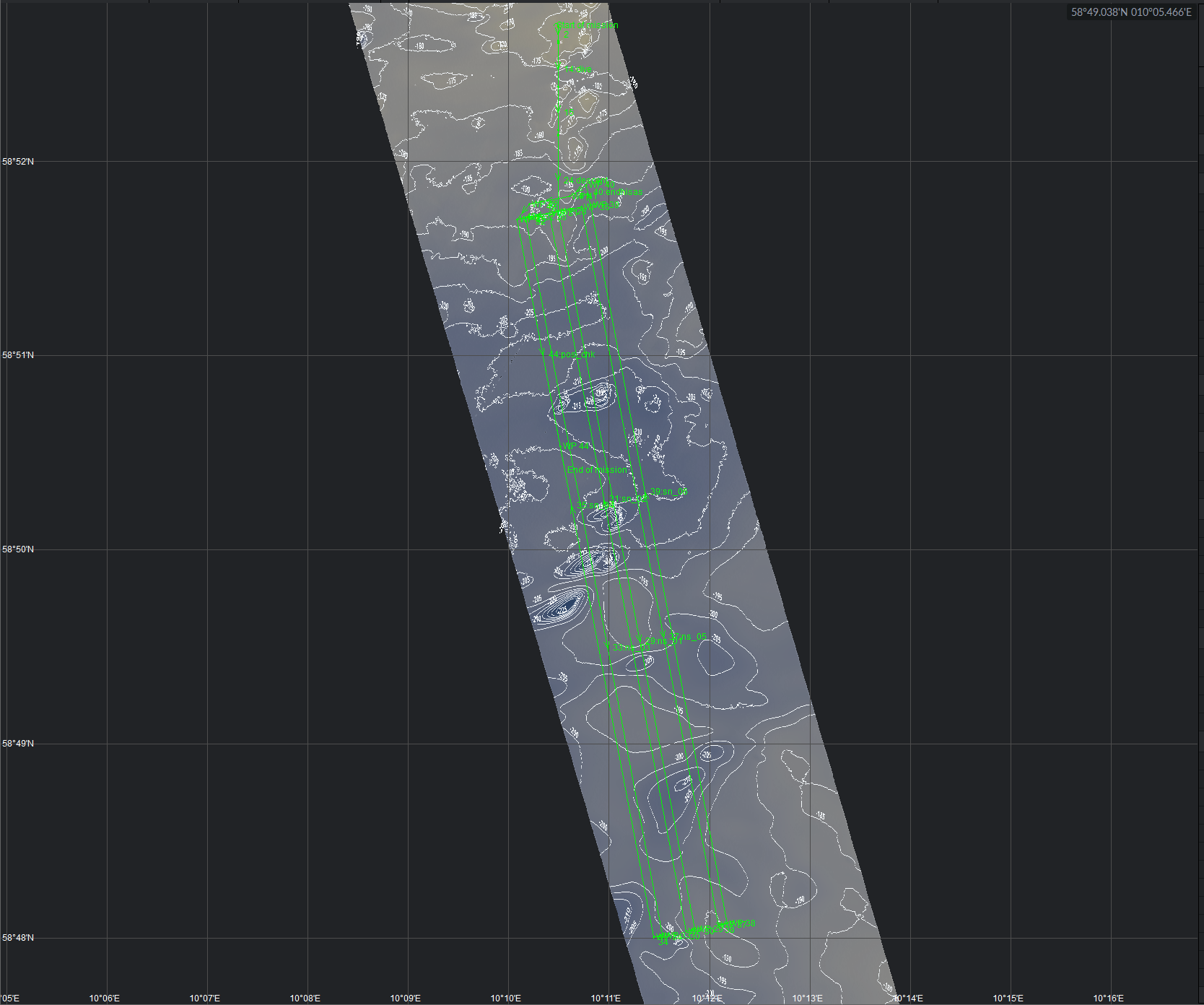
The second dive took place over a relatively flat 200m deep zone in the easternmost declassified area.
The aim wsa to cover as much surface as possible during a short window of weather suitable for recovery of the AUV. The whole dive could not be carried out and had to be aborted after 4h 50m to ensure safe recovery on board. Hisas data was collected in a grid pattern flying at 20m altitude to offer a high resolution view of the seabed so small objects could be visually detected Initial inspection of the hisas data also revealed large number of trawlmarks. Sub-bottom profiler was also switched on during the dive for an assessment of the sensor by geologists.
8.2.1 - Mission plan Dive 2
# Kongsberg Maritime AUV Mission Plan
# Saved 2023-10-10 06:21:14 by hugin
#:Tag Depth Alt DMo Latitude Longitude Course GMo Speed SMo Dur Dist Flags
# Speed up
:speed 0.0 20.0 D - - 180.0 H 2.30 S 30 - EMPowerOn
: = = = - - = = = = 60 - SASPowerOn
# NB: Remember to set Safe 20m and Crit 10m distance in Startup parameters!
: = = = - - = = = = 1 - ETPowerOn
# Are we waiting enough for payload to boot?
: = = = - - = = = = 1 - SafeDist10
: = = = - - = = = = 1 - CritHeight6
: = = = - - = = = = 1 -
: = = = - - = = = = 1 -
: = = = - - = = = = 1 -
: = = = - - = = = = 1 -
: = = = - - = = = = 1 -
: = = = - - = = = = 1 -
: = = = - - = = = = 1 -
: 0.0 = = - - = = = = 1 -
# Start dykk til 30m for aa sjekke at alt er ok
:dive 100.0 = = - - = = = = 180 -
: 100.0 = = - - = = = = 180 -
# Jump from here to repeat dive, health check here
:health = = = - - = = 2.00 S 20 -
: = = = - - = = = = 1 - Auto
# Submerged, vehicle configuration
:config = = = - - = = = = 1 - RollCtrlOn
: = = = - - = = = = 1 -
: = = = - - = = = = 1 -
: = = = - - = = = = 1 - SASHighPower
: = = = - - = = = = 1 - SASMode1
: = = = - - = = = = 1 - ETOn
# Descent to working depth (100 m / 3 min), Activate HiSAS
:descent 195.0 = T - - 180.0 = = = 360 - SASOn
: = = = - - = = = = 1 -
: = = = - - = = = = 1 -
:setalt = 20.0 = - - = = = = - -
# Lead-in to Survey Pattern
:leadin = = = 58:51.7434N 010:10.4904E (180) = = = - -
:ns_01 = = = 58:48.0441N 010:11.8531E (169) = = = (3495) (6992)
: = = = 58:48.0356N 010:11.7662E (259) = = = (42) (85)
:sn_02 = = = 58:51.7344N 010:10.4041E (349) = = = (3495) (6991)
: = = = 58:51.7111N 010:10.1688E (259) = = = (115) (230)
:ns_03 = = = 58:48.0122N 010:11.5316E (169) = = = (3495) (6991)
: = = = 58:48.0039N 010:11.4437E (260) = = = (43) (86)
:sn_04 = = = 58:51.7012N 010:10.0822E (349) = = = (3494) (6988)
: = = = 58:51.7660N 010:10.7268E (079) = = = (315) (632)
:ns_05 = = = 58:48.0673N 010:12.0882E (169) = = = (3495) (6991)
: = = = 58:48.0758N 010:12.1750E (079) = = = (42) (85)
:sn_06 = = = 58:51.7747N 010:10.8139E (349) = = = (3495) (6991)
:endhisas = = = 58:51.8795N 010:10.7705E (348) = = = (99) (199)
# position check
: = = = 58:51.8200N 010:10.6035E (235) = = = (97) (195)
: = = = 58:51.7808N 010:10.2052E (259) = = = (194) (390)
: = = = 58:51.7013N 010:10.0824E (219) = = = (94) (189)
# position check?
:pos_chk = = = 58:50.5320N 010:10.5133E (169) = = = (1105) (2210)
: = = = - - = = = = - 50 Ascent
9 - Appendix 2 – Biology summary
| Location | P No | R no | VL | Notes |
| KB-Utsira | P36 | 3284 | 3446 | Ikke logging. test ROV ved ubåt HMS Thistle. |
| Skagerrak | P37 | 3366 | 3447 | Biology: Plukket: porifera branched dense. Over en kløft. Fjellvegg ned og opp dekket i novocrania, viftesvamp(VME sponge garden), serpulidae. Mixed sediments på bunn av kløft, og siste del på toppen av vegg , munida, stichastrella,Bonellidae og noe viftesvamp. |
| Skagerrak | P38 | 3367 | 3448 | Climbing up a steep wall. Rich fauna. Sponge garden all the way(Axinellidae). Dense population of basketstars in the beginning. Lots of lost fishing gear. Nephrops eating Myxine in the start. 2 cores in the start. Rock with porifera picked by ROV. |
| Skagerrak | P145 | 3368 | 3449 | Seapen garden with funiculina and sponge garden with Porifera branched dense, Phakellia, Axinella, Axinellidae alternating VMEs |
| Skagerrak | P44 | 3369 | 3450 | Svamphager (geodial, Porifera branched dense). Pandalider. |
| Skagerrak | P41 | 3372 | 3451 | Virularidae red sampled at start. Station aborted 19:25 due to weather. |
| Skagerrak | P50 | 3373 | 3452 | Pandalidae, Myxine, Trisopterus, Pollachius virens Lost 4k rec after 17min. |
| Skagerrak | P51 | 3370 | 3453 | Cerianthidae bottom. Pandalidae. cerianthus lloydi. Biology: |
| Skagerrak | P52 | 3370 | 3454 | Pandalidae. pseudamussium septemradiatum. (P-51) |
| Skagerrak | P53 | 3370 | 3455 | Biology: Pandalidae. parastichopus. calocarides and possible juveniles swimming in hole. |
| Skagerrak | P54 | 3370 | 3456 | Parastichopus, Trisopterus,virgularia, kophobelemnon, Seapen garden bedrock at the end. Rich fauna. Sampled two rock with rich fauna at the end |
| Skagerrak | P55 | 3374 | 3457 | parastichopus,Pandalidae,cerianthus lloydii, Trisopterus, virgularidae red, Myxine. |
| Skagerrak | P56 | 3374 | 3458 | Seapen garden. Sampling stylatula cf |
| Skagerrak | P57 | 3375 | 3459 | cerianthidae bottom, burrows. sampling stylatula cf |
| Skagerrak | P15 | 3376 | 3460 | opp to små vegger med acesta, svamp, og novocrania. VME sjøfjærbunn siste halvdel med kophobelemnon, funiculina og virgularia. også en del parastichopus, munida og pandalidae. |
| Utenfor Lista | P15 | 3377 | 3461 | VME seapen garden hele veien, kophobelemnon, funiculina, og noe virgularia. VME koraallhage med isidella i flekker alle årsklasser. Flekker medgracilechinus og noe thenea. plukker 3 isidella. en god del knekt funiculina |
| Utenfor Lista | Extra | 3377 | 3462 | VME seapen garden hele veien. Noe VME korallhage med isidella, alle årsklasser, mye små individ mot slutten. Sjøfjær dominert av kophobelemnon og funiculina. flekker med mye garcilechinus. OBS transekt utvidet med 100m (300m totalt). plukket en liten isidella. |
| Hardanger | P53 | 3378 | 3463 | Lophelia reef, madrepora. små paramuricea, noen paragorgia, clavularia borealis og anthothela grandiflora. Mye geodia, forskjellige arter og mycale. munida, asteroidea og cerianthidae i korallgrusen. Healthy reef. |
| Hardanger | P54 | 3379 | 3464 | VME hydrocoral hard bottom, dominated by stylaster and paramuricea. seastar collected. Sponge garden VME dominatedby geodia species and mycale. Lots of murida and lithodes. Live Lophelia reef, clavelaria borealis. patches of madrepora before reef. Litter. |
| Hardanger | P55 | 3380 | 3465 | parastichopus, Munida, pandalidae, Thenea. Some seapens, Funiculina, virgularia, spisskate (Dipturus oxyrinchus). eptmopterus spinax. |
| Hardanger | P56 | 3381 | 3466 | Brisinga,anthomastus, asconema . sampled brisinga and asconema |
10 - Appendix 3 – Geologic summary
| P nb | R nb | Video | Back-scatter | Video | Grab/Push core | Quality | Notes |
| Utsira | |||||||
| submarine dive + grab | VL3446 | sandy mud, gravelly sandy mud, MSGC | good | Test dive at the submarine area, 2 surface samples taken from a grab, one for HI, one for NGU. | |||
| Skagerrak | |||||||
| P36 | R3366 | VL3447 | strong | BCB/SGCB, GSM, exp bedrock, | - | good | line through 50 m deep bedrock fracture, GCB/SGCB on both sides of fracture, exposed bedrock on slopes, gravelly sandy mud mainly at the bottom of fracture, no PC taken due to very coarse sediments |
| P37 | R3367 | VL3448 | strong | sandy mud, exposed bedrock | sandy myd | good | Line starting arouund 309 m in sandy mud. Steep climb up bedrock slope towards the west to ca. 200 m depth. 2 push cores from sandy mud and 2 bedrock samples from cliff. Sandy mud in hand sample from push core. Crystalline bedrock (gneis/mica schist) in bedrock sample. |
| P38 | R3368 | VL3449 | medium | sandy mud, bedrock, MSGCB | sandy mud/mud | good | Mud with very minor sand and gravel in beginning and end of line (in video described as sandy mud), short interval of bedrock and long interval of MSGCB in the middle of line, PC taken from beginning |
| P145 | R3369 | VL3450 | strong | sandy mud, exposed bedrock | sandy mud | good | Sandy mud alternating with exposed bedrock I steep cliff. Bedrock partly layered, probably Cambrosilurian. Massive bedrock may be larvikite. |
| P44 | R3372 | VL3451 | weak | mud | good | mud at landing site, line aborted shortly after lift off due to bad weather | |
| P41 | R3373 | VL3452 | weak | mud | mud | good | 5 push cores for carbon analyses. 1: slighktly outside TM, 2: in old TM, 3: in fresh TM, 4: in very fresh TM, 5: outside TM, lost core 2 during retrieval |
| P50 | R3370 | VL3453 | - | sandy mud | mud | good | sandy mud with burrows, push core for hand sample |
| P51 | R3370 | VL3454 | - | sandy mud | good | sandy mud with burrows, a few TMs, a few cobbles | |
| P52 | R3370 | VL3455 | - | sandy mud | mud | good | push core for hand sample |
| P53 | R3370 | VL3456 | - | sandy mud | mud | good | push core for hand sample |
| P54 | R3374 | VL3457 | - | mud | mud | good | mud and burrows throughout, many TMs towards the end of line, push core for hand sample |
| P55 | R3374 | VL3458 | - | mud, exposed bedrock | good | mud in the beginning of the line, intervals of bedrock in the middle and mud with scattered cobbles and boulders in the end, bedrock is often covered with thin layer of mud | |
| P56 | R3375 | VL3459 | - | mud | mud | good | mud with burrows, one push core |
| P57 | R3376 | VL3460 | - | mud, exsposed bedrock | mud | good | Mud, but two intervals of exposed bedrock. Many TMs in the beginning. Push core in bottom of old TM at beginning of line. |
| P15 | R3377 | VL3461 | - | mud | sandy mud | good | mud with burrows, a few gravelly areas, one push core. Change to sandy mud in the logger |
| P15 | R3377 | VL3462 | - | mud | - | good | mud with burrows, a few MSGCB areas. Change to sandy mud in the logger |
| extra VL | R3378 | VL3463 | - | bioclastic sediments | - | good | Coral reef alternating live coral mounds, dead coral mounds, coral rubble dominated by sandy gravel. One little bedrock exposure. Fishing gears. |
| extra VL | R3379 | VL3464 | - | G/GCB/bioclastic sediments | sandy gravel | good | Mostly coarse sediments, with G(SG) and GCB(SGCB) for more than half of the line, some bioclastic sediments (shell and tube fragments) at the surface, comet marks. Bioclastic sediments (coral rubble, coral block and live lophelia) on the last third of the line. Sample taken with ROV spade. |
| extra VL | R3380 | VL3465 | - | mud | mud | good | mud and abundant burrows throughout, |
| extra VL | R3381 | VL3466 | mud/exposed bedrock | mud | good | wreck at the beginning of the line. Line started with mud with burrows, then long exposed bedrock cliff with here and there some mud cover and burrows. 1 pushcore. Long line (c. 3h record, splitted in 2) | |