



Toktrapport for 2026007006 dekker aktivitetene på Mareanos andre cruise til den arktiske midthavsryggen (AMOR) fra april til mai 2026. Metodene fra det forrige tokt ble utvidet under dette tokt for å bedre passe til behovene for arbeid på dyphavet, inkludert noe nytt eller modifisert utstyr brukt til fysisk prøvetaking sammenlignet med det forrige tokt. Denne rapporten beskriver aktivitetene som ble utført, med en beskrivelse av klassifiseringene for live-annotering som ble brukt og skript for etterbehandling, i tillegg til en mer detaljert beskrivelse av utplasseringsmetodene som ble brukt for det fysiske utstyret som ble brukt under fullstasjonene. Den inneholder også en oversikt over ROV-dykkene, prøvene og foreløpige resultater utledet fra SFO-loggene. Opplevde begrensninger og anbefalinger for fremtidige Mareano-tokt finnes på slutten av cruiserapporten.
MAREANO's second cruise to the Arctic Mid-Ocean Ridge
— 2026007006 MAREANO Cruise Report
Report series:
Toktrapport 2026-17
ISSN: 1503-6294
Published: 29.06.2026
Cruise no.: 2026007006
Project No.: 16156-03
On request by: MAREANO
Research group(s):
Bunnsamfunn
Program:
Marine prosesser og menneskelig påvirkning
Research group leader(s):
Sigurd Heiberg Espeland (Bunnsamfunn)
Approved by:
Research Director(s):
Geir Lasse Taranger
Program leader(s):
Frode Vikebø
Norsk sammendrag
Summary
The 2026007006 Cruise Report covers the activities of MAREANO’s second cruise to the Arctic Mid-Ocean Ridge (AMOR) from April to May 2026. The methods from the previous cruise were expanded on during this cruise to better fit the needs of working in the deep sea, including some new or modified gear used for physical sampling compared to the previous cruise. This report describes the activities performed, with a description of the live-annotation classifications used and scripts for the post-processing, in addition to more detailed description of the deployment methods used for the physical gears used during the full stations. It also includes an overview of the ROV dives, samples, and preliminary results derived from the SFO logs. Limitations experienced and recommendations for future MAREANO cruises are provided at the end of the cruise report.
Acknowledgements
We would like to start this cruise report by thanking the R/V Kronprins Haakon and NORMAR ROV Ægir6000 crew for all the hard work that they did during the cruise to make our work possible and to collect high quality samples. It was a pleasure to work with everyone onboard, and we look forward to continuing doing so in the future. We would also like to thank Anne Helene Tandberg and Saskia Brix for their assistance with finalizing the deployment methodology for the Agassiz Trawl and Brenke Sled used during this cruise.
1 - Introduction
MAREANO is an interdisciplinary seabed mapping programme comprised of the Norwegian Mapping Authority, The Geological Survey of Norway, and The Institute of Marine Research. The programme is tasked with gathering baseline ecodiversity information through the collection of bathymetric, geological, biological, and chemical data that can be used for management needs across the deep Norwegian/Greenland Sea within the area opened for mineral activity. Parts of deep Norwegian Sea have been identified as a particularly vulnerable and valuable areas (SVO-områder: Særlig verdifulle og sårbare områder på norsk; NH4; Meld. St. 21 (2023–2024) - regjeringen.no). Thus, filling in knowledge gaps of the region and identifying areas of environmental importance have been recognized as a need by the Ministry of Climate and the Environment.
Norway’s continental boundary in the deep Norwegian/Greenland Sea encompasses the heterogeneous multi-segmented ultra-slow spreading ridge system known as the Arctic Mid-Ocean Ridges (AMOR) before transitioning to more homogeneous abyssal plains on either side of AMOR. AMOR is located between Greenland and Norway and is made up of 5 spreading ridge segments - Ægir, Kolbeinsey, Mohn’s, Knipovich, and Gakkel Ridge, with Jan Mayen Ridge positioned between Ægir and Kolbeinsey but of continental origin. The main ridge axis has a large depth gradient – generally ranging between >3500 m to <500 m depth, though areas can be shallower or deeper. The plains on either side of AMOR are well below 2000 m on average.
Multiple water masses interact with AMOR. Cool and low salinity Greenland Polar Water is present at the surface, intermediate waters (Greenland Arctic Intermediate Water and Norwegian Arctic Intermediate Water) forms between the surface and deep water, and in the deep basins on either side of AMOR there is the cooler and fresher Greenland Sea Deep Water in the Greenland Basin and Upper Norwegian Deep-Water and Norwegian Sea Deep Water in the Norwegian side.
MAREANO Cruise 2026007006 is MAREANO’s second cruise to AMOR. It continues where MAREANO cruise 2025007011 left off (https://www.hi.no/hi/nettrapporter/toktrapport-en-2025-11), starting off the main rift valley on the Mohn’s Ridge and moving northwest into the Greenland Sea.
1.1 - Stations
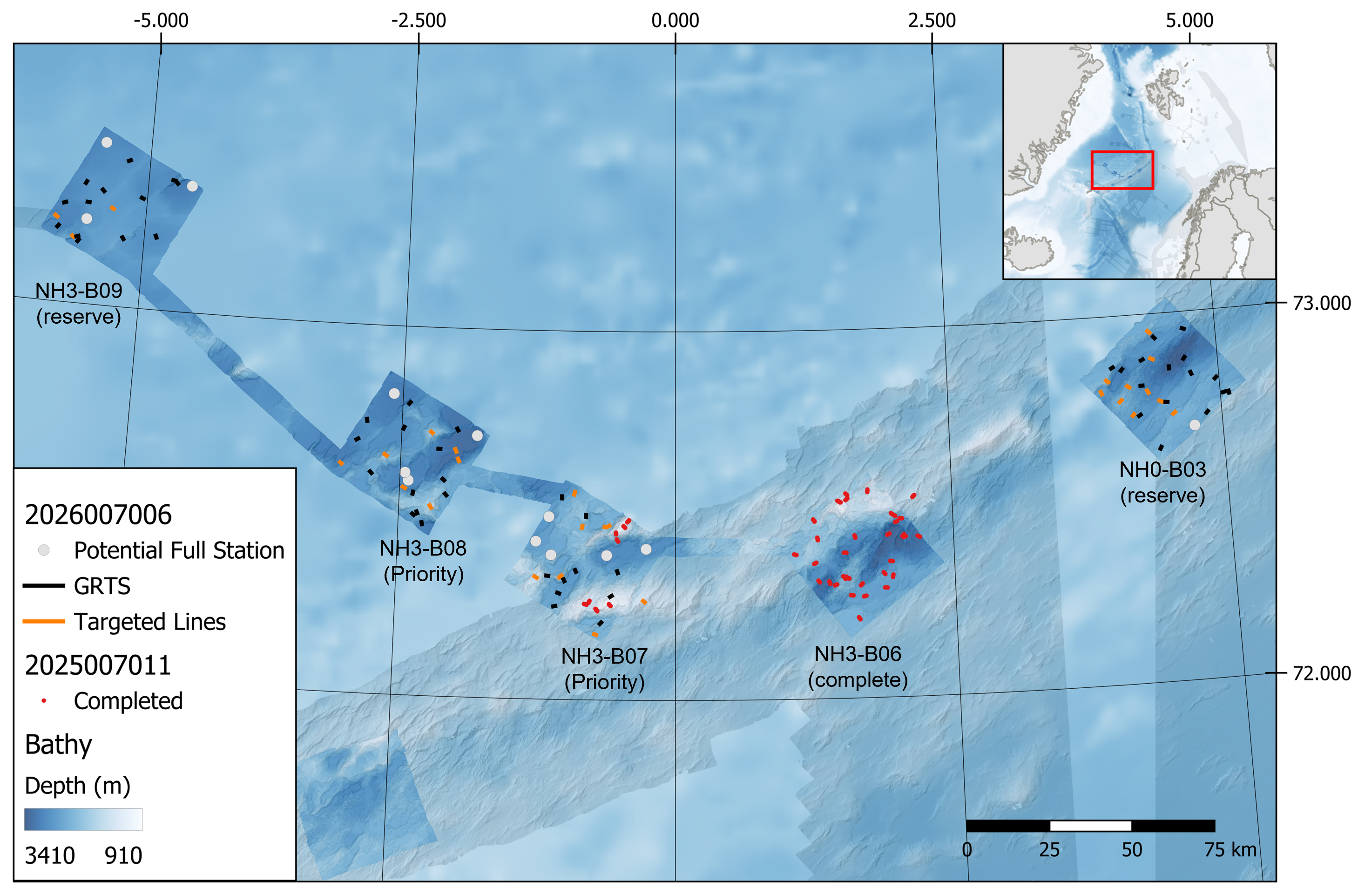
The priority areas for Cruise 2026007006 were NH3-B07 and NH3-B08, with NH3-B09 and NH0-B03 acting as reserve boxes should time allow (Figure 1). The priority boxes together contained 47 stations with 4 full stations (2 per box). The reserve boxes contained 46 stations together with 4 full stations (2 per box). Opportunistic bathymetry and sub-bottom profile would be collected while transiting between stations and survey boxes.
NH3-B07 (approx. 1300 km2) was the first planned box (Figure 2), continuing from where MAREANO Cruise 2025007011 left off. It was located off the main spreading axis on Mohn’s Ridge and contained heterogeneous terrain consisting of ridges, seamounts, and deep basins. There were 13 GRTS (Gen-eralized Random Tessellation Stratified) and 10 Targeted stations planned, with 5 potential full stations selected. The first planned station was outside of the box and selected due to its shallow crest at 1050 m, indicating the possible presence of a bamboo coral aggregation. The remaining stations within the box had a depth range between 1130 and 2930 m depth, with an average around 2350 m.
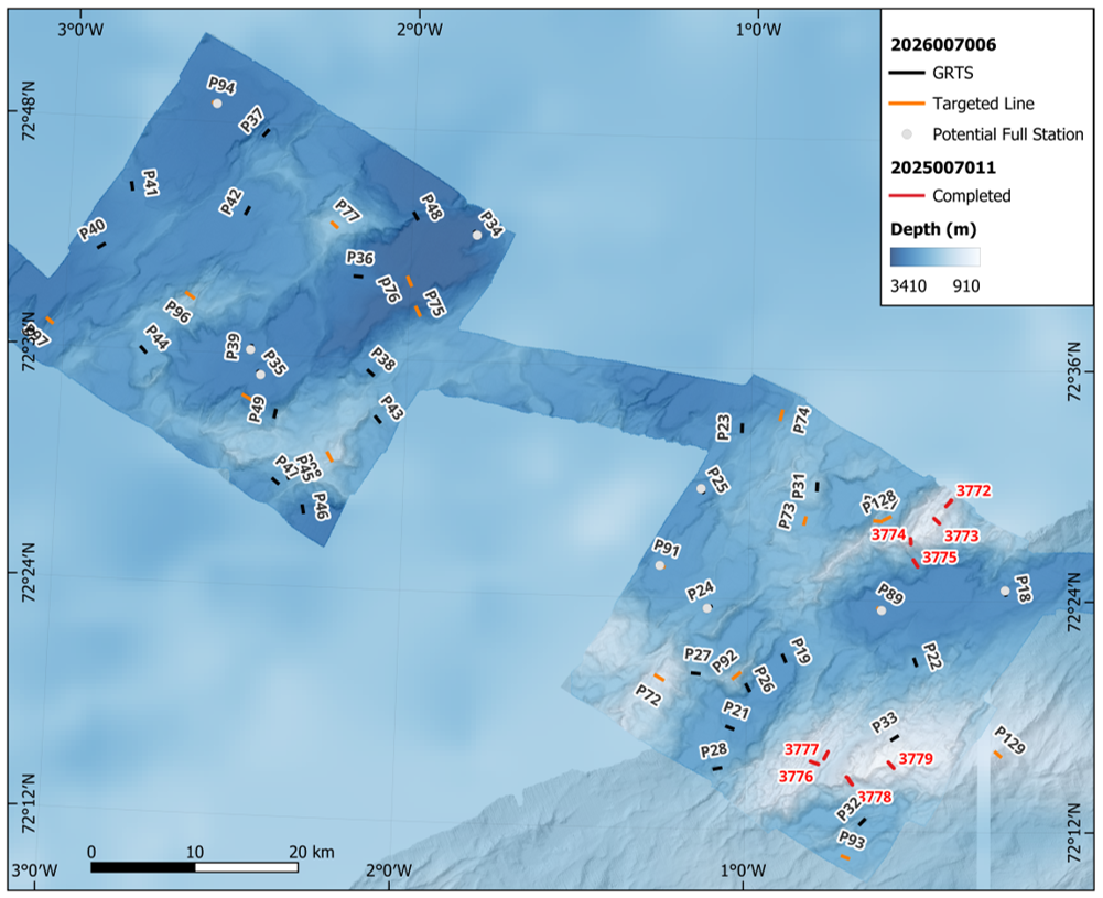
NH3-B08 (approx. 1300 km2) was the next priority box (Figure 2). It was located northwest of NH3-B07, off the spreading axis and consisted of more homogeneous terrain (compared to NH3-B07), with small seamounts and deep basins. It had a depth range between 1845 and 3260 m, with an average depth of 2775 m. There were 16 GRTS and 8 Targeted stations planned, with 4 potential full stations.
2 - Cruise Participants
| Name | Institute | Role |
| Riley (Heidi Kristina) Meyer | IMR | Cruise Leader |
| Roy Holger Robertsen | IMR | Instrument Chief |
| Sebastian Grieg Pedersen | IMR | Instrument |
| Kjell Bakkeplass | IMR | Data Management |
| André Bienfait | IMR | Chemist |
| Josefina Johansson | IMR | Biologist |
| Èric Jordà Molina | IMR | Biologist |
| Camille Saint-André | IMR | Biologist |
| Yngve Klungseth Johansen | IMR | Biologist |
| Irina Zhulay | IMR | Biologist |
| Nils Piechaud | IMR | Biologist |
| Marta Gil González | IMR | Biologist |
| Marlene Pinheiro | CIIMAR | Biologist |
| Inês Albuquerque | CIIMAR | Biologist |
| Daniel Hesjedal Wiberg | NGU | Chief Geologist |
| Christine Tømmervik Kollsgård | NGU | Geologist |
| Valérie Bellec | NGU | Geologist |
| Celine Golda | NGU | Geologist |
| Solveig Osjord | NOD | Observer |
| Frode Evensen | Contractor | ROV Day Supervisor |
| Jonas Broberg | Contractor | ROV Pilot |
| Marcus Bivren | Contractor | ROV Pilot |
| Björn Löfqvist | Contractor | ROV Night Supervisor |
| Johan Sköld | Contractor | ROV Pilot |
| Kai Roger Loven | Contractor | ROV Pilot |
| Hallgeir M. Johansen | IMR | Captain |
| Eirik Lund | IMR | Chief Officer |
| Per Bær | IMR | 1st Officer |
| Roy Karlsvik | IMR | Chief Engineer |
| Cato Fagevold | IMR | 1st Engineer |
| Andreas Turøy | IMR | 2nd Engineer |
| Bjarte Norheim | IMR | Electrician |
| Hans Erik Jimmy Westberg | IMR | Chief Steward |
| Silje Olsen | IMR | Cook |
| Vilde Høgstø | IMR | Stewardess |
| Rita Mikkelsen | IMR | Stewardess |
| Frank Boska | IMR | Fishing Master |
| Jan Erik Hansen | IMR | Fishing Net Man |
| Alf-Erik Murberg | IMR | Able Seaman |
| Bjørn Erlend Strømmen | IMR | Able Seaman |
| Arve Otterlei | IMR | Able Seaman |
| Jan Inge Thoresen | IMR | Able Seaman |
| Karl Kallevik | IMR | Motorman Apprentice |

3 - Methodology
Due to the great depths and heterogeneous environment, the methods used in the MAREANO deep-sea surveys differs from the standard MAREANO cruises on the continental shelf. While the MAREANO 2025007011 Cruise Report (https://www.hi.no/hi/nettrapporter/toktrapport-en-2025-11) provided detailed overview of many of the changes applied for the deep-sea environment, updated protocols are described below for future reference.
3.1 - Acoustics
As for standard MAREANO cruises, sub-bottom profile (SBP) and multibeam were collected when in transit between stations. Transit speed between stations was typically around 10 knots. Once on the station, the vessel speed was reduced to 5 knots to allow for better acoustic data to compare with the corresponding video line.
3.1.1 - Sub-bottom profiler SBP 300
Sub-bottom profiles were collected with a SBP 300 Kongsberg using a chirp pulse 2.7-7 kHz and acquisition window of 500 ms, Automatic window calculated the delay from depth and unsynced ping system would ping upon receiving the previous pulse.
3.1.2 - Multibeam echo sounder EM 302
Multibeam was collected with SIMRAD/Kongsberg EM 302 rated to a depth range from 10 – 7000 m. The swath width was set to 55 degrees, with a limitation on maximum width to 2000 m. Depth mode was set to automatic up to station R3785 (P18). Changed to “Very Deep” mode thereafter to be able to produce backscatter from collected data.
3.2 - CTD
Five dedicated CTD (Conductivity, Temperature and Depth) stations were taken per box and collected pressure, temperature, salinity, dissolved oxygen, sound velocity, and fluorescence within the water column. The small 12 bottle rosette (SBE 32) with 10 L Niskin bottles and Seabird sensor (SB 09/11) was deployed from the CTD hangar onboard. Bottom water was collected from the CTDs taken at full stations and 2 of the shallowest stations per box for eDNA.
Ægir6000 also had a CTD that was turned on during the ROV descent for the dives and collected pressure, temperature, and conductivity.
3.3 - Video Lines
As a new standard for working in the deep sea, video lines were adjusted from the standard 200 m to 600 m long, where there would be 3x 200 m long dedicated transects per video line (Figure 3). Some specific targeted stations had 800 m long lines with 4x 200 m long dedicated transects. Sampling and investigation were only possible in sections between the 200 m long transects.

3.4 - Remotely Operated Vehicle (ROV)
Deep-sea MAREANO surveys on AMOR used NORMAR’s (https://www.normardeepsea.com/) work-class remotely operated vehicle (ROV) Ægir6000 manufactured by Kystdesign AS (Haugesund, Norway) with a depth rating of 6000 m water depth (Photo 2). Its dimensions are 2.75 x 1.70 x 2.20 m with the tool skid and has a load capacity of 350 kg. It has a hydraulic drawer mounted on the skid, two manipulator arms (TITAN 4 and ATLAS) with a lift capacity of 122 and 250 kg, respectively. There are two Imenco Spinner II (HD) cameras mounted on the top and center of the ROV with two green Manta Ray mk2 Parallel Lasers mounted on the center camera and spaced 9.5 cm apart. A Tethered Management System (TMS) attached above the ROV improves its stability and operability while in use.
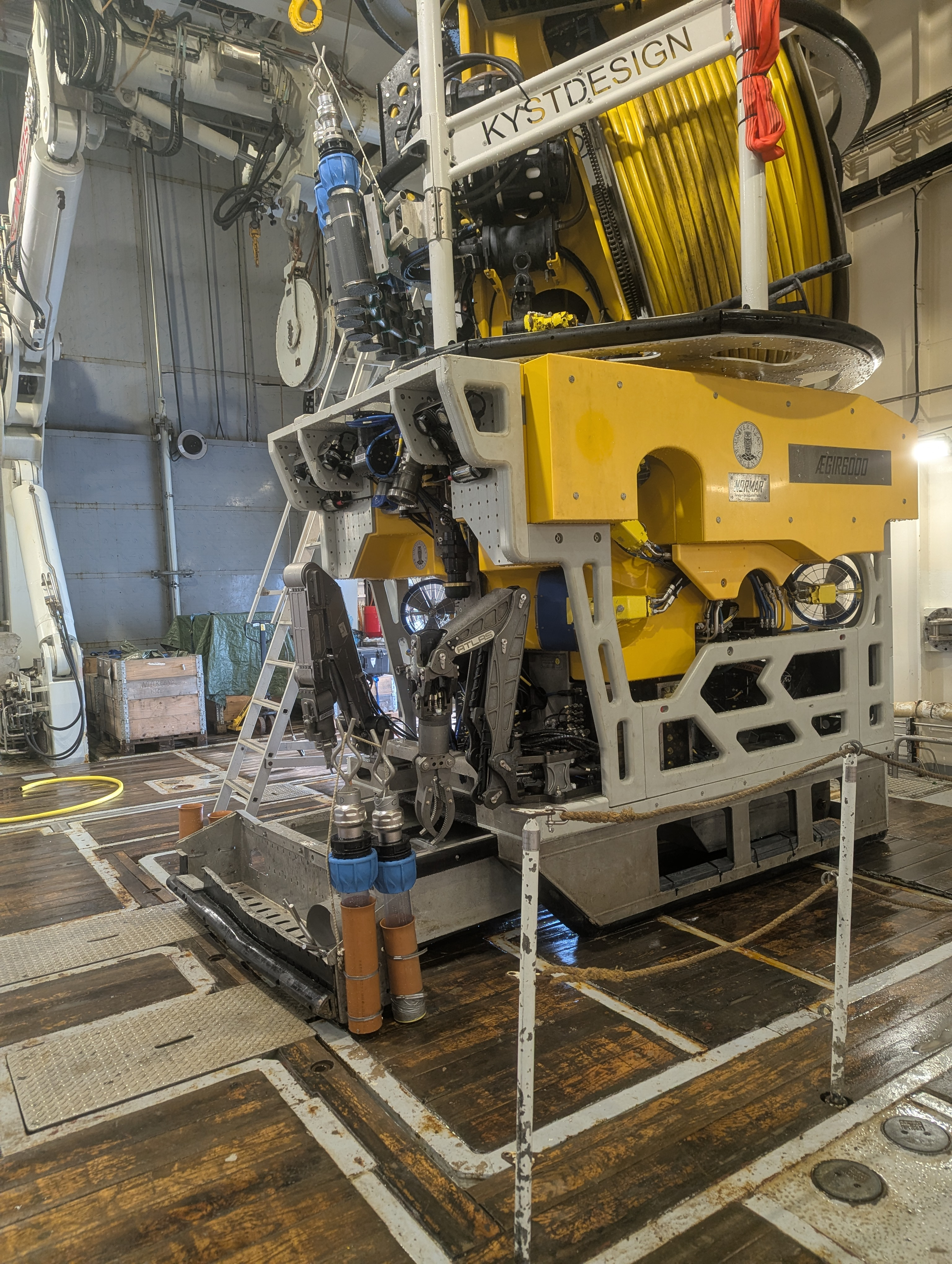
Biological, geological, and chemistry samples were collected by Ægir6000 during the dives. Ægir6000 would also remain at the seafloor during the deployment of drop gear on the full stations (See Section 3.6 - Full stations) to observe, guide, and assist the sampling of the drop gear, should it be needed. Each sampling event with the ROV would gain a rolling “Event ID” number, which would be logged in Seabed Field Observer (SFO, described below in Section 3.5 - Seabed Field Observer (SFO)) with the Event ID, gear type, sample name, and time of collection.
During a standard dive, not a full station, the following gear were mounted onto the ROV:
-
4 plastic push corers (90 mm) mounted on the drawer (2 on each side)
-
5 plastic and 2 aluminium push corers (110 mm) mounted on the TMS
-
3 mesh nets (1 long, 1 short, 1 wide)
-
1 “Frankenstein” scoop
-
2 toolboxes (for biological/geological samples)
-
1 knife
Additional gear brought for specific dives in targeted stations or stations with specific conditions were:
-
2 niskin bottles (for eDNA)
-
1 mini-multicorer prototype (for eDNA sediment sampling for the external project OptiMiSe)
-
2 blade corers with the transparent plexiglass plates (for biological samples; in place of 2 push corers mounted on the skid)
Additional gear brought for full stations were:
-
2 niskin bottles (for eDNA)
-
2 blade corers with aluminium plates (for chemistry) or plexiglass plates (for biology)
-
2 aluminium push corers mounted on the TMS (in place of 2 plastic push corers; for chemistry)
3.5 - Seabed Field Observer (SFO)
An IMR in-house annotation software named Seabed Field Observer (SFO) was used for live video annotation during the video lines. Here, operational comments (e.g. start/stop), morphotaxa, litter, and seabed features were logged as they occurred, whereas seabed bottom type and habitat type were logged at 10 second intervals. SFO is connected to Toktlogger and retrieves navigation and depth data from Toktlogger as they are logged. Due to difficulties with retrieving the correct telegrams from the ROV into SFO, a script was used to retrieve the correct ROV navigation data during post-processing.
The methodology regarding biological annotations was modified with the aim to annotate general trends in morphotaxa or the general morphology of a taxon rather than to species level (Table 2). In contrast to what was done during the last cruise, morphotaxa occurrence was registered regularly as one entry (i.e. logged as one abundance to show presence), instead of logging the relative abundance of a morphospecies. In addition, the 1st observation of a known species on a video line was logged to infer species diversity and help identification during post-cruise video analyses. These changes were made to increase reliability and consistency of live annotations between annotators. To make logging in SFO easier to navigate, morphotaxa names were given a shorthand and then corrected with a script to the accepted MAREANO Names (used for video analysis post cruise).
| Primary level | Morphotype/additional characteristics | Taxonomy examples | SFO Button | MAREANO Video Name |
| Annelida-Echiura | Echiura | AnnEch | Echiura | |
| Annelida-Errantia | Polychaeta mobile | Polynoidae | AnnErr | Polychaeta errantia |
| Annelida-Hirudinea | Hirudinea | AnnHir | Hirudinea | |
| Annelida-Sedentaria | Polychaeta tubes | Serpulidae, Sabellidae | AnnSed | Polychaeta sedentaria |
| Arthropoda-Amphipoda | Amphipoda free-living | Themisto sp., Lyssianassidae, Stegocephalus sp., | ArtAmp | Amphipoda |
| Amphipoda burrowing | Neohela sp. | ArtBurrow | Neohela sp. | |
| Arthropoda-Cirripedia | Cirripedia | Catherinum strialatum | ArtScalp | Scalpellidae |
| Arthropoda-Decapoda | Caridea | Bythocaris sp., Lebbeus sp. | ArtCar | Caridea |
| Arthropoda-Isopoda | Isopoda | Saduria sp. | ArtIso | Isopoda |
| Arthropoda-Mysidae | Mysidae | ArtMys | Mysidae | |
| Arthropoda-Pycnogonida | Pycnogonida | Nymphonidae, Colossendeis sp. | ArtPycno | Pycnogonida |
| Biota - bush | Bryozoa/Hydrozoa bush | BioBush | Biota bush | |
| Biota - encrusing | Encrusting | BioEnc | Biota encrusting | |
| Biota - general | BioGen | Biota | ||
| Brachiopoda | Brachio | Brachiopoda | ||
| Bryozoa | Hard | Idmidronea sp., Lichenopora sp. | BryHard | Bryozoa hard |
| Bryozoa | Soft bush | BryBush | Bryozoa bush | |
| Chordata-Ascidiacea | Encrusting | Didemnidae | AscCol | Ascidiacea colonial |
| Solitary | Molgulidae, Ciona sp., Ascidia sp. | AscSoli | Ascidiacea solitary | |
| Chordata-Fish | Codlike | Gadidae, Lotidae, Macrouridae | FishCod | Gadiformes |
| Eelpout | Zoarcidae, Lumpenidae | FishEel | Zoarcoidei | |
| Flatfish | Pleuronectiformes | FishFlat | Pleuronectiformes | |
| General fish | Teleostei | FishGen | Teleostei | |
| Ray | Rajiformes | FishRay | Rajiformes | |
| Sculpin | Psychrolutidae | FishSculp | Psychrolutidae | |
| Shark | Selachii | FishShark | Selachii | |
| Snailfish | Liparidae | FishSnail | Liparidae | |
| Cnidaria - Ceriantharia | Buried / tube-dwelling | Ceriantharia | CerBuried | Cerianthidae |
| Cnidaria-Actiniaria | Buried / tube-dwelling | Actiniaria dark purple, Edwardiidae | ActBuried | Actiniaria buried |
| Epizoic | some Hormathiids | ActEpi | Actiniaria epizoic | |
| Solitary | Typical sea anemones | ActSoli | Actiniaria solitary | |
| Cnidaria-Coral | Bamboo coral | Keratoisididae | CorBam | Keratoisididae |
| Other coral | Scleractinia, Antipatharia, Gorgonians, Anthomastinae, Octocorallia | CorOther | Anthozoa | |
| Sea pen | Umbellula sp. | CorPen | Pennatuloidea | |
| Soft coral | Gersemia sp. | CorSoft | Alcyoniidae | |
| Cnidaria-Hydrozoa | Solitary | Candelabrum sp., Tubulariidae | HydSoli | Hydrozoa solitary |
| Bush | HydBush | Hydrozoa bush | ||
| Epizoic | HydEpi | Hydrozoa epizoic | ||
| Cnidaria-Medusae | Mdusa (Stauromedusae) | Stauromedusae, Lucernaria bathyphila | MedStau | Stauromedusae |
| Medusa (Trachymedusae) | Crossota sp., Ptychogastria sp. | MedTrac | Trachymedusae | |
| Ctenophora | Cteno | Ctenophora | ||
| Echinodermata-Asteroidea | Asteroidea | Solasteridae, Tylasteridae, Lophaster sp. | EchAst | Asteroidea |
| Echinodermata-Crinoidea | Stalked | Bourgueticrinina, Bathycrinus carpenterii | CriStalk | Bourgueticrinina |
| Unstalked | Comatulids, Poliometra prolixa | CriUnstalk | Antedonoidea | |
| Echinodermata-Echinoidea | Regular | Strongylocentrotus sp. | EchReg | Echinoidea regular |
| Irregular | Pourtalesia sp. | EchIrreg | Echinoidea irregular | |
| Echinodermata-Holothuroidea | Holothuroidea | Elpidia sp., Kolga sp. | EchHolo | Elpidiidae |
| Echinodermata-Ophiuroidea | Ophiuroidea | Typical ophiuroids | EchOph | Ophiuroidea |
| Ophiuroidea branching | Gorgonocephalus sp. | EchGorg | Gorgonocephalidae | |
| Mollusca-Bivalvia | Bivalvia boring | MolBoring | Teredinidae | |
| Bivalvia | Pectiniidae, Bathyarca sp. | MolBiv | Bivalvia | |
| Bivalvia burried | Limatula sp. | MolBuried | Bivalvia sp. burried | |
| Mollusca-Cephalopoda | Decapodiformes | Decapodiformes | MolCeph | Decapodiformes |
| Octopodiformes | Cirroteuthidae, Cirroteuthis muelleri | MolOcto | Cirroteuthidae | |
| Mollusca-Gastropoda | Gastropoda | Buccinidae, Naticidae | MolGastro | Gastropoda |
| Nudibranchia | MolNudi | Nudibranchia | ||
| Nemertea | Nemer | Nemertea | ||
| Porifera | Encrusting | Hymedesmidae, Hexadella dedritifera | PorEnc | Porifera encrusting |
| Bush | Lissodendoryx (Lissodendoryx) complicata, Asconema foliatum, Aphrocallistidae | PorBush | Porifera bush | |
| Carnivorous | Cladorhizidae, Cladorhiza spp., Licopodina spp., Asbestopluma spp. | PorCarn | Cladorhizidae | |
| Fan | Axinellidae, Phakellia sp. | PorFan | Porifera fan | |
| Massive | Stelletta rhaphidiophora, Geodia parva | PorMass | Porifera massive | |
| Round | Polymastiidae, Tentorium semisuberites, Polymastia thielei, Geodia hentchelli, Craniella spp., Thenea spp., Spinularia spp. | PorRound | Porifera round | |
| Stalked | Saccocalyx sp., Caulophacus (Caulophacus) arcticus, Amphidiscella monai, Stylocordyla borealis | PorStalk | Porifera stalked | |
| Tube | Hemigellius sp., Asconema megaatrialia, Schaudinnia rosea, Scyphidium septentrionale, Trichasterina borealis | PorTube | Porifera tube |
Logging broad habitat type by-eye was also done during the cruise to give us a first glimpse of the type of habitats that were observed for each video line (Table 3). We defined the habitats as visually consistent (continuous or semi-continuous) areas associated with sessile, three-dimensional animals (animal forest) or burrowing megafauna that form complex structures, provide habitat complexity, shelter, and are often biodiversity hotspots. A taxon is considered dominant when it forms a continuous or near-continuous pattern that structures the seabed and is repeatedly observed across frames for several seconds. It is visually distinct and defines the overall appearance of the “scene”. Even though multiple habitats could co-occur, SFO currently does not allow for multiple habitats to be logged at the same time. To maintain consistency, only a maximum of 2 habitats were combined into one SFO button for interval logging.
| Habitat Type | Definition |
| Anemone wall | Area with dense coverage of anemones on hard bottom. May occur in small patches with complete coverage. |
| Bamboo coral garden | Area with patches of bamboo coral on thinner or no bamboo coral framework. May have other habitat-forming fauna glass sponges, Geodia spp., soft coral, etc. growing on the framework. |
| Bamboo coral reef | Area with continuous coverage of bamboo coral framework with both live and dead bamboo coral. May have other habitat-forming fauna glass sponges, Geodia spp., soft coral, etc. growing on the framework. |
| Brittle stars and pectinid bed | Area with complete coverage of visible brittle stars and pectinids laying on the ground on soft or hard bottom. |
| Brittlestar bed | Area with complete coverage of visible brittle stars laying on the ground on soft or hard bottom. |
| Brittlestar bed and sabellid field | Area with complete coverage of visible brittle stars laying on the ground with continuous observations of sabellid tubes on soft bottom. |
| Buried bivalve bed | Area with dense coverage of visible Limutula sp. "holes" coming in pairs in soft bottom |
| Carnivorous sponge garden | Areas with semi-continuous observations of carnivorous sponges on hard or soft bottom |
| Cerianthid garden | Area with continuous/semi-continuous observations of cerianthids on soft bottom |
| Geodia and glass sponge ground | Area of continuous/semi-continuous observations of Geodia/Stelletta and Schaudinnia/Scyphidium/Trichasterina glass sponges (not Aphrocallistidae /Asconema foliatum) on hard bottom or spicule mat |
| Geodia ground | Area with dense coverage of Geodia spp./Stelletta sp. on spicule mat. Often has bush, stalked, encrusting, and/or fan sponges present. |
| Geodia wall | Area of dense coverage of Geodia spp./Stelletta sp. on hard bottom. Often has bush, stalked, encrusting, and/or fan sponges present. |
| Glass sponge garden | Area of continuous/semi-continuous observations of Schaudinnia rosea, Scyphidium septentrionale, Trichasterina borealis glass sponges (does not include Aphrocallistidae /Asconema foliatum) on hard bottom or spicule mat |
| Glass sponge garden and brittle star bed | Area of continuous/semi-continuous observations of Schaudinnia rosea, Scyphidium septentrionale, Trichasterina borealis glass sponges (not Aphrocallistidae /Asconema foliatum) and dense coverage of brittle stars on hard bottom or spicule mat. Often has bush, stalked, encrusting, and/or fan sponges present. |
| Hardbottom sponge ground | Area of continuous/semi-continuous observations of encrusting, fan, stalked, round, and bush sponges on hard bottom. |
| Hardbottom sponge ground with unstalked crinoid garden | Area of continuous/semi-continuous observations of encrusting, fan, stalked, round, and bush sponges with dense coverage of unstalked crinoids on hard bottom. |
| Neohela aggregation | Area with continuous coverage of Neohela sp. burrows on soft bottom. May have other fauna such as anemones, urchins, or sponges present. |
| Pectinid bed | Area with complete coverage of visible pectinids laying on the ground on soft or hard bottom |
| Sabellid field | Area with continuous coverage of sabellids on soft bottom. May have other fauna such as anemones, seapigs (Elpidia sp. or Kolga sp.), sponges, and urchins present. |
| Sclerolinum forest | Areas with dense coverage of siboglinidae worms (Sclerolinum and Nicomache sp.) that occur at diffuse venting areas and cold seeps. |
| Soft coral garden | Area with dense coverage of soft corals on hard or soft bottom. |
| Stalked crinoid / sabellid field | Area with either or both stalked crinoids (Bathycrinus carpenterii) and sabellids on soft bottom but it is either too difficult to tell them apart or both are appearing regularly - only use this when it is not clear if it is one or the other or if it is clearly both. May have other fauna such as anemones, seapigs (Elpidia sp. or Kolga sp.), sponges, and urchins present. |
| Stalked crinoid field | Area with continuous coverage of stalked crinoids (Bathycrinus carpenterii) on soft bottom. May have other fauna such as anemones, seapigs (Elpidia sp. or Kolga sp.), sponges, and urchins present. |
| Stalked crinoid field and Neohela aggregation | Area with continuous coverage of stalked crinoids (Bathycrinus carpenterii) and Neohela sp. burrows on soft bottom. May have other fauna such as anemones, seapigs (Elpidia sp. or Kolga sp.), sponges, and urchins present. |
| Thenea ground | Areas with continuous observations of Thenea sp. sponges on soft bottom or spicule mat. |
| Umbellula garden | Area with continuous/semi-continuous observations of Umbellula sp. on soft bottom. |
| Unstalked crinoid garden | Area with dense coverage of unstalked crinoids on hard bottom with no sponges present. Tends to occur on hardbottom sponge grounds. |
| Urchin graveyard | Area with continuous coverage of dead Pourtalesia sp. tests. Often has anemones or fauna associated with high organic content present. |
For geology, the seabed was classified into bottom types that indicates the content and grain sizes of the sediment. Bottom types have certain threshold values of the different grain sizes from mud – boulders, which defines each class, an abbreviated version is given in Table 4. Push cores were used to verify bottom types based on visual classification from the video lines.
| Seabed Bottom Type | Mud | Sand | Gravel |
| Mud | More than 90% | Less than 10% | Up to 2% |
| Sandy Mud | More than 50% | Less than 50% | Up to 2% |
| Muddy sand | Less than 50% | More than 50% | Up to 2% |
| Gravelly sandy mud | Dominating grain size | 10 – 50 % | 2 – 30 % |
| Gravelly muddy sand | 10 – 50 % | Dominating grain size | 2 – 30 % |
| Muddy sandy gravel | 10 – 90 % in mud-sand fraction | 10 – 90 % in mud-sand fraction | More than 30% |
| Mud and sand with gravel, cobbles and boulders | More than 20 % mud in the sediment | Poorly sorted sediment with varying composition of sizes from mud – boulders. | |
| Sand, gravel and cobbles | Less than 20 % mud in the sediment | Varying composition of sizes, sand is more abundant than mud, and lacking in boulders. | |
| Sand, gravel cobbles and boulders | Less than 20 % mud in the sediment | Poorly sorted sediment with varying composition of sizes, sand is more abundant than mud. | |
| Gravel, cobbles and boulders | Less than 20 % of mud and sand in the sediment | More than 80 % of gravel, cobbles and boulders | |
After each dive, the SFO reports were manually checked by Geologists and Biologists to remove errors, add summaries of each video transect and ensure all the important information, especially the operational commands, were entered correctly. Then, several post-processing steps were applied through R scripts. All the code and its logic are available at: https://git.imr.no/bunnsamfunn_mareano/sfo-data-on-kph.
The resulting tables are 2 versions of the raw SFO reports. One contains all the information required by Marbunn and the other contains the information related to the video files (start times of each file, names) and the sub-sections in the videos that will be used at the analysis stage in BIIGLE 2.0 (https://biigle.de/).
The different portions of each video lines were incorporated into the names of the video files and ROV position files in the data archive. This dataset was also used to produce the species accumulation curves used to evaluate the completeness of the sampling in each box.
3.6 - Full stations
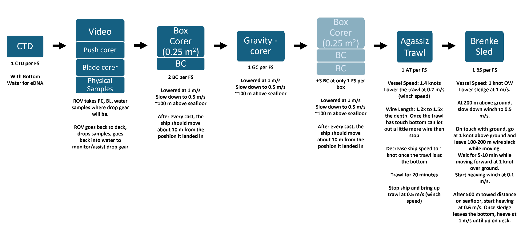
Two full stations were selected in each survey box (NH3-B07 and NH3-B08) for more extensive physical sampling for benthic biology, geology, and chemistry (Figure 4). Full stations were typically confirmed during the ROV dive to ensure the sediment was suitable for all of the physical sampling gear. Although, some stations required evaluation of the sediment content post dive due to some stations having very soft sediment unsuitable for the drop gear. We followed and expanded on the procedures described in the MAREANO 2025007011 Cruise Report.
3.6.1 - eDNA water sampling
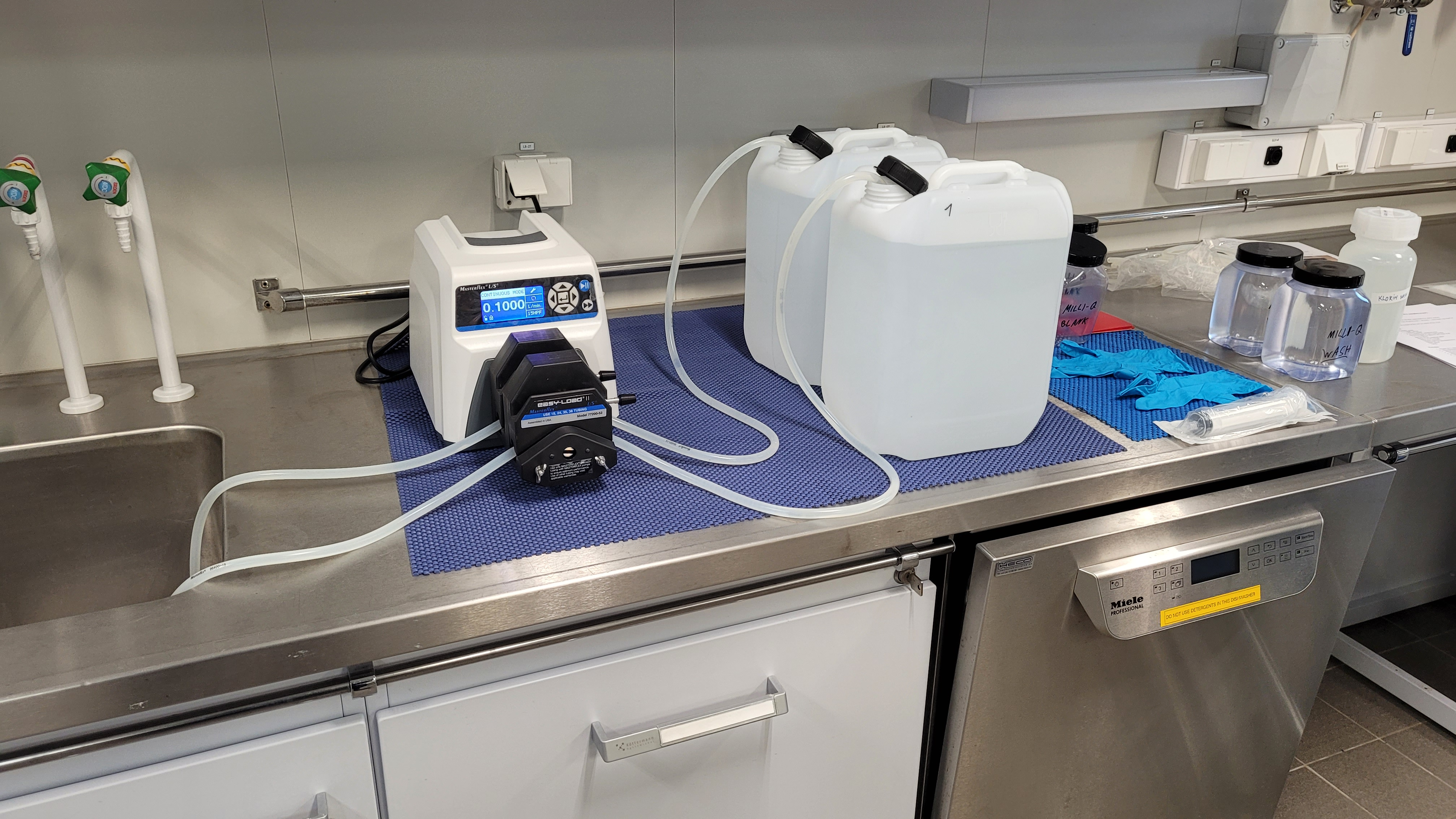
In each full station, two samples from the CTD and two samples from the Niskin bottles from the ROV where processed. The setup and protocol established for the workflow in the laboratory is detailed below (Photo 3):
- Prepare 20% chlorine solution by mixing 1 part chlorine and 4 parts milli-Q water.
-
Decontaminate the work area with 20% domestic chlorine solution (add chlorine, leave for 5 min, wipe off, rinse with water).
-
Mount pump and tubings in the working area (2), separate description. Since there are only two tubes available it was necessary to do 2 rounds of filtering for each station (1 for the CTD samples and another for the Niskin samples). Color code the tubing and note down which tubing (tubing #) is used for filtering which samples.
-
Decontaminate the tubing by running (speed 0.1 L/min) a few milliliters of 20% chlorine solution through the two tubes. While doing this, make sure to immerse the tubing sufficiently into the chlorine solution. Use the dedicated 1 L bottle for this and keep the level of solution high. Stop the pump and leave chlorine for 5 min. Empty the tubing by running air through the tubing.
-
Rinse the tubing by running (speed 0.1 L/min) 2x1 liter of milli-Q water through the two tubes. In the first step, use the bottle labelled “MILLI-Q WASH 1”. Make sure to immerse the tubing sufficiently into the milli-Q water to wash off the chlorine from the outside of the tubing. When “MILLI-Q WASH 1” is empty, refill it with 1 L milli-Q water from “MILLI-Q WASH 2” and continue pumping until empty. Empty the tubing by running air through the tubing. Place the lock on the top to keep the tubing safe and clean.
-
Decontaminate 2 10L jerry cans by adding some chlorine solution (~0.5 L), cap, shake and leave for minimum 5 min or until being used. Empty the can completely. Rinse until you cannot smell the chlorine, about 4x 0.5 L milli-Q water, cap, shake, and empty completely.
-
To decontaminate the tubing leading from the Niskin bottle to the jerry cans, submerse them into the dedicated bottle with 20% chlorine solution and leave them for at least 5 min, make sure the tubes are filled with solution. Transfer them into the dedicated bottle with milli-Q water labelled “Stage 1”, make sure the tubes are filled with water. After a few minutes, transfer them into the dedicated bottle with milli-Q water labelled “Stage 2”, make sure the tubes are filled with water. Refill “MILLI-Q WASH 2” from step 5 with 1 L milli-Q water, place the tubing into the pump, the ends into the bottle and pump the water through to wash. Empty the tubing by running air through the tubing. Place the lock on the top to keep the tubing safe and clean.
-
Make an air blank by filling a new (for each day) sterile 50 ml syringe with air and blow it through a sterivex filter twice. Place the filter in a sterile 50 ml centrifuge tube (labelled) for storage in the freezer. This is to detect any airborne DNA in the sampling area.
-
Remember to include a water blank (5 L milli-Q water) at each station and follow the description in point 11. Run the milli-Q blank first to save you additional cleaning. Make a note of which tube is filtering which sample.
-
When one arrives at a station, sampling for eDNA is the first activity to occur. This is to avoid contamination from other equipment that has been in the water (such as trawls). The CTD with Niskin bottles rosette is run down to the bottom and on the way up collect water at desired depths (bottom). Collect water from 2 Niskin bottles into the 2 10 L jerry cans .
-
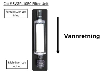
Place a sterivex filter at the end of tubing and filter (speed 0.1 L/min) 5 liters of water of each jerry can. Run air through the filter for minimum one minute. Remove the filter from the tubing and dry the filter by pushing 50 ml air through it with the syringe. Shake to release any drops of water from the filter. Place the filter in a prelabelled 50 ml centrifuge tube with the outlet end down (Figure 5).
-
Repeat step 4-6 for the next two samples at the same station.
-
Place all samples from the same station, including blanks, in a labelled zip bag and store it in the freezer (- 80 °C). Each bag for each station was labeled as: “eDNA Mareano Norskehavet 2025., Tokt nr, stasjons nr, Project. name, Havforskningsinstituttet.”
-
Check if the CTD/Niskin bottles needs cleaning/decontamination before the next sampling.
-
Repeat step 4-13 for each new station.
To keep track of the samples, a sample sheet was used where all the samples for each station (including blanks) where registered.
3.6.2 - Blade Corer
Samples for emerging contaminants were collected with blade corers equipped with metal side panels to avoid potential contamination from the plexiglass used during biological sampling. Once the ROV was safely on deck, the chemist took control of the blade corers. They were brought out on deck away from crew members and other scientific personnel to reduce the likelihood of sample contamination during sub-sampling. For the sub-sampling the upper part of the metal side panels was carefully unscrewed and opened. Thereafter, sampling was performed generally following the established protocol (https://www.mareano.no/resources/Metodedokument-Kjemiprogram-2024.pdf).
Blade cores with plastic transparent walls were used to collect macrofauna. For some selected stations, two blade core replicates were deployed next to each other. Once on deck, the cores were kept upright, and the height of the sediment profile was measured with a ruler and photographed prior to opening of the plastic walls. Once the cores were opened, the sediment was sieved over a sequential sieving over fractions of 1 mm, 0.5 mm and 0.3 mm mesh sieves. All content was preserved in ethanol 96%.
3.6.3 - Push cores
Plastic push cores with an outer diameter of 90 mm are used throughout the survey area to ground-truth the interpretations of the seabed observed in the video lines. Usually, two or more are mounted on the side of the ROV-drawer for ease of use in sampling. The core content is immediately analysed once onboard and logged and documented on paper and in Survey123.
On this cruise, push cores with an outer diameter of 110 mm replace the regular multi corer (MC) sampling for chemistry. The plastic cores are the same as we would use for the MC (without flenses), and the metallic cores are a new set of aluminium cores. All of these wide cores (5 plastic and 2 aluminium) are stored on the TMS. The TMS is lowered closer to the seabed during the sampling stage to speed up the process (22 – 75 min on the five stations with an average of 36 minutes). Once all the cores are on board, we check if enough cores are approved (minimum 3 plastic and 1 steel), measure their height, and decide the owner (NGU/IMR). Photos are then taken of the cores with a scale and label (station and core number). We also take photos of the surface of core A and B before slicing them and describe core A in detail (on paper + Survey123). Core A is the longest plastic core, and the slices are sent for inorganic contaminants, grain size, and other sediment characteristics measurements at NGU. Core B is a plastic tube core for measuring organic contaminants at IMR. The two-three shortest plastic tube cores and two steel tube cores are sealed for later measurements such as XRI (C) and microplastics (E-F) at NGU and IMR. Due to expected low sedimentation rates, we subsample the sliced cores, slicing them into 0.5 cm thick slices in the top 10 cm of the cores and 1 cm slices below (normal MAREANO standard is 1 cm). Sliced samples were stored frozen (-18 °C) and sealed cores stored at ambient temperature.
3.6.4 - Gravity Corer
Gravity cores were collected at the full stations with the aim of establishing sedimentation rates and genesis of the area. The gravity corer used was MAREANO/NGU’s gravity corer with a casing allowing core lengths of up to 5 m samplings. The crew added all the available weights to the head of the gravity corer (800 kg) and handled both deployment and retrieval of the gravity corer. Before deployment the geologists prepared and added the core liner, core catcher, and core cutter to the gravity corer. It was then lowered at 1 m/s throughout the water column. At about 100 m above the seafloor, the winch was slowed down and the ROV Ægir6000 made visual contact with the gravity corer. Then both, the ROV and the gravity corer descended simultaneously (at about 0.5 m/s) allowing to visualize the landing. A few metres above the seabed the gravity corer is allowed to free-fall into the sediment, thus filling the core liner. Upon retrieval the cores were labelled, cut into 1 m sections, and stored cold (+4 °C) before shipment to NGU for further analysis.
3.6.5 - Box Corer (0.25 m2)
Box corers were deployed to quantitatively assess macrofaunal communities down to seizes of 300 µm (or 0.3 mm).
At each full station, two to five USNEL 0.25 m2 box corer (rented from Akvaplan-Niva) replicates were collected. Usually, deeper stations were targeted with the 5 replicates, while shallower stations were targeted with the 2 replicates.
The crew loaded the box corer and it was lowered at 1 m/s throughout the water column. At about 100 m above the seafloor, the winch was slowed down and the ROV Ægir6000 made visual contact with the box corer. Then both, the ROV and the box corer descended simultaneously (at about 0.5 m/s) allowing to visualize the landing of the box corer and verify successful trigger of the closing mechanisms of the spade. In case that the closing mechanism did not release and the box corer lifted off in an open position, the box corer was moved about 10 m from the original landing spot, and another attempt was tried. In case of doubt, the closing mechanism of the box corer was triggered using the ROV arm by pulling a rope connected to the closing mechanism. This avoided conducting blind sampling and retrieving empty box corers up to deck, preventing this way losing a considerable amount of time in case of failed sampling.
Each box corer cast was equipped with a transponder to extract geographical positions upon landing on the seafloor.
Upon retrieval on deck, the box with the closed spade was detached from the box corer frame and it was secured for further processing. Pictures were taken with the overlaying water. After, the overlaying water was removed by carefully suctioning the water with a hose over a 0.3 mm mesh sieve. The content of the sieve was preserved with 96% ethanol. Another picture without the overlaying water was taken of the sediment surface. Then, the box corer was divided into two halves by placing one metal pla te divider. Half of the box corer was further processed and fixed with formaldehyde 4% with borax, while the other half was preserved in ethanol 96%. This approach was chosen in order to strive for an end-to-end taxonomy approach in which morphotypes and genetically sequenced organisms could be matched afterwards.
Before any other processing, two replicate samples for eDNA analyses were taken from the “ethanol” half of the box corer, while one sample for sediment pigments concentration was taken from the “formaldehyde” half with a 60 mL cut-off syringe for the 0-2 cm sediment surface. The eDNA samples and the sediment pigment samples were both frozen at -80 °C.
Each half of the box corer was then processed separately as explained in the cruise report from the first deep-sea MAREANO cruise to the AMOR region (https://www.hi.no/hi/nettrapporter/toktrapport-en-2025-11). In short, the 0-5 cm layer for each box core-half was scooped out and sieved through a sequential sieving procedure with sieves of 1 mm, 0.5 mm and 0.3 mm mesh sizes in that order. The sieve contents were fixed in ethanol 96% (for the ethanol half) and in formaldehyde 4% (for the formaldehyde half). After that, the 5-15 cm layer for each half was scooped out of the box corer and elutriated into a 0.3 mm sieve for about 1 hour with an elutriated system described in detail in the MAREANO 2025007011 Cruise Report (see link above). The elutriated content in the sieves for each box core-half was fixed with the respective fixative (ethanol or formaldehyde) and the heavy fraction from both box core-halves were combined and fixed in formaldehyde 4%.
For material preserved in ethanol 96%, the ethanol was replaced after 12 hours and samples were kept as cold and dark as possible.
3.6.7 - Agassiz Trawl
One Agassiz trawl per full station was conducted to collect epifaunal megafauna, larger epifauna, and near-surface living infauna samples and obtain a semi-quantitative assessment of their community composition, abundance, and biomass. The trawl samples can provide a more comprehensive epifaunal sampling than targeted ROV sample collection alone. Physical specimens are required for detailed taxonomic examination, particularly for smaller or morphologically similar taxa that are difficult to identify from imagery alone. They also provide voucher material for the development and validation of reference DNA libraries, which are still sparse for many Arctic deep-sea taxa, and currently limit the application of such methods as eDNA monitoring.
Among available trawl types, the Agassiz trawl was selected as a robust and practical sampling tool under conditions of the deep-sea ridge environment. It allows better manoeuvrability in the complex geomorphological terrain and is easier to deploy at great depths, while still providing sufficient sample material. Also, it can land both sides and still retrieve a good sample.
For this cruise, and compared to the previous MAREANO cruise, the inner net was replaced by a 4 mm (half mesh) net size, substituting the previous 1 cm mesh, and allowing comparison with previous MAREANO trawls in the shelf (Photo 4). The trawl had a horizontal frame of 3.16 m, with an effective net opening of 2.19 m and a height of about 30 cm.
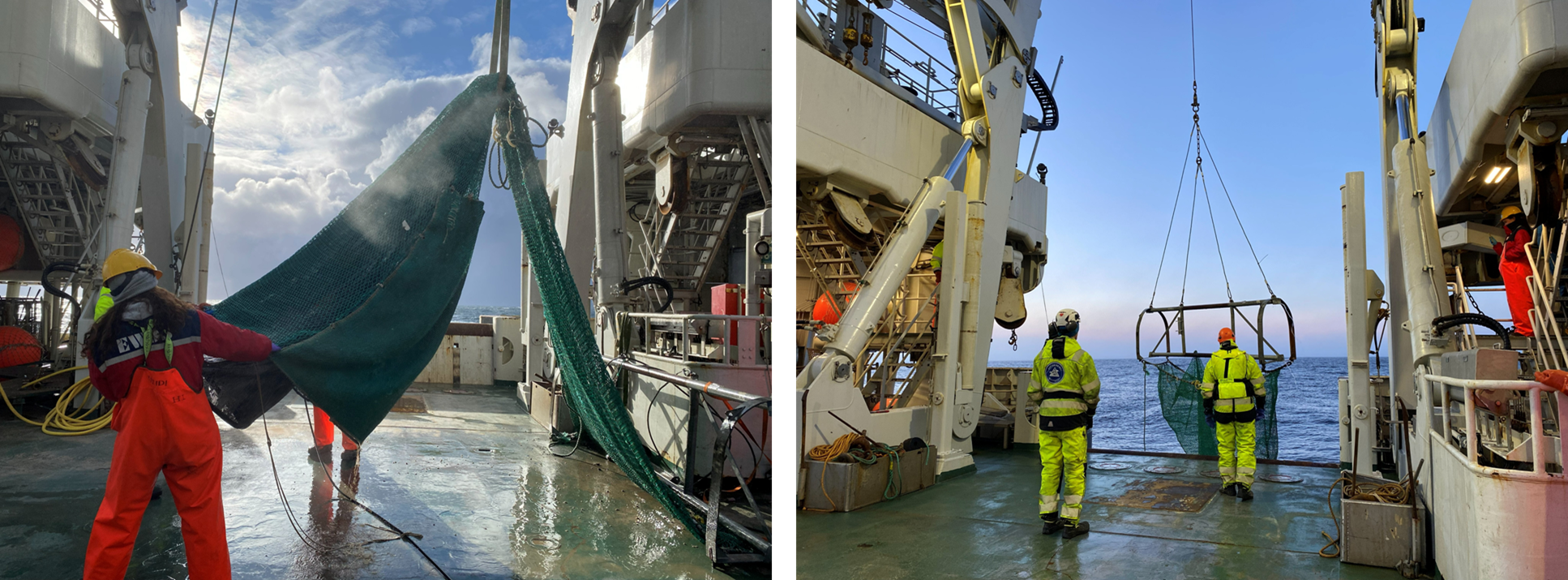
A transponder attached to the wire approximately 100 m above the trawl was used to estimate geographical positions in contact and lift off with seafloor, and to adjust the amount of wire deployed. Given that it was not possible to mount the transponder on the trawl frame due to too rough conditions while trawling and the danger to damage or lose this equipment, a Starmon TD Temperature Depth Recorder from STAR ODDI (referred to as Seastar) was mounted on the trawl frame to get high resolution depth profiles of the trawl casts and more accurate depth and timestamps estimates of the real position of the trawl. While the Seastar does not send real time data and does not record geographical coordinates, the depth data is less noisy than the one recorded with the transponder, making it more suitable to define timestamps of contact and liftoff with the seafloor which can afterwards be matched with the timestamps of the transponder and derive geographical coordinates.
During the trawl deployment, vessel speed was maintained at approximately 1.4 knots while the trawl was lowered at a winch speed of 0.7 m/s. Wire length was generally maintained at approximately 1.2 - 1.3 times the water depth to ensure seabed contact. Once the trawl reached the seabed, vessel speed was reduced to approximately 1 knot, and trawling began. After a towing period of 20 min, the vessel was stopped, and the trawl was hauled at a winch speed of approximately 0.5 m/s. The trawl typically remained in contact with the seabed for several additional minutes (about 8 additional minutes) during hauling before lift-off.
Depth values to associated timestamps from the Seastar were smoothed using a centered rolling mean (21-point window), and vertical velocity was calculated as the rate of change in smoothed depth. Bottom contact was defined as the first observation where depth exceeded 98% of the trawl-specific maximum and vertical velocity was below 0.15 m/s, while lift-off was identified as the first subsequent time point where depth became shallower than the bottom-contact depth minus a trawl-specific lift threshold (between 5 and 20 m). These timestamps were used to derive bottom-contact and where matched to closest neighboring timestamps for the transponder data. Given that transponder data was quite noisy, the positions recorded along the trawled track were filtered to remove spurious locations based on a speed threshold of 0.5 m/s, converted to a long-track distance, and smoothed using locally weighted regression (LOESS; span = 0.15) applied separately to projected x and y coordinates to derive a continuous centerline representation of the trawl path. The smoothed track was constrained to the observed start and end positions (derived from Seastar) to preserve endpoint accuracy. Trawled distance was then calculated as the cumulative distance along this smoothed centerline, while straight-line distance between start and end positions was estimated using the haversine formula. Wire length data were additionally matched to bottom-contact and lift-off times to estimate gear deployment dynamics.
The swept area was calculated based on towing distance and trawl opening.
Upon retrieval, the catch was emptied into a tub, and the net was carefully rinsed to recover organisms retained in the net. The sample was subsequently washed through a series of sieves with mesh sizes of 5 mm, 2 mm, and 0.5 mm. The 5 mm sieve corresponds to the standard used in the MAREANO program, enabling direct comparison with previous datasets. The 2 mm sieve was included to facilitate comparison with other deep-sea epifaunal studies and to assess the extent to which smaller benthic fauna may be missed when using larger mesh sizes, particularly given that smaller organisms tend to dominate deep-sea benthic communities with increasing depth. The 0.5 mm fraction was retained and transferred to the University Museum of Bergen for further qualitative investigation of smaller organisms.
The catch was documented photographically prior to preservation in ethanol (EtOH), which may alter organism shape and coloration, thereby facilitating later comparison between physical specimens and organisms observed in video footage. Stones were inspected for attached fauna before removal from the samples. The collected material was preserved in 96% EtOH, and the ethanol was changed after approximately 12 hours. The collected material will be further processed on land at the Tromsø sorting laboratory and subsequently sent to taxonomic experts for further examination of the material, counting, and weighing. Samples of fish, cephalopods and wood were frozen at −20°C. For fish species that could be identified to species level on board, individuals were counted, weighed, and then discarded, as no further taxonomic inspection was required.
3.6.8 - Brenke Sled
For this cruise, MAREANO has opted to implement for the first time the use of a Brenke sledge instead of an RP (Rothlisberg-Piercy) sledge to collect the hyperbenthic fraction of benthic communities in the deep sea (and small macrofauna). The main difference between both epibenthic sledges is that while the RP sledge has only one net, the Brenke sledge has two nets on top of each other (the epinet, closer to the seafloor, and the supranet, on top of the epinet). Another big difference is that while the net of the RP sledge is just dragged on top of a rubber mat, the nets of the Brenke sledge are completely protected by a metal frame, and the cod ends are secured to the metal frame as well. This makes the Brenke sledge more suitable to sample in rougher and deeper conditions, making it the preferred gear for deep-sea sampling. Also, another advantage is that the Brenke sledge can be placed vertically on deck upon retrieval. This makes it easier to rinse the samples in the net and get rid of as much mud as possible before processing and decanting the samples.
A Brenke sledge was rented from Senckenberg (Germany), specifically the sledge “META” (Photo 5).
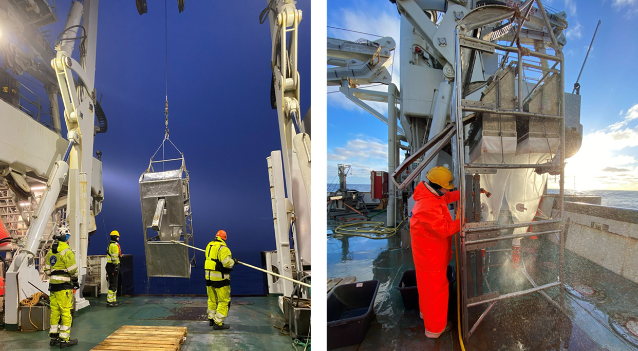
The sledge dimensions 345x120 (l x h) cm, the epi-and supra net boxes are 1.00 m wide and 0.35 m high, epi-and supra net boxes are 1.00 m wide and 0.35 m high and reach from 0.25 to 0.60 m (epibenthic sampler) and from 0.77 to 1.12 m (suprabenthic sampler) above the sledge floor. The epi- and supra net mesh sizes are 0.5 mm, while the cod-ends have a mesh window of 0.3 mm. The cod-ends and the nets are separated by a valve that opens into the direction of the cod-end, but that prevents the sample from coming out again. The sledge is equipped with lever unit and doors which close in the water column without contact with the seafloor. The transponder was attached to the frame all dives.
For the deployment of the sledge, the vessel speed was 1 knot above water while the sledge was lower at a winch speed of 1 m/s through the water column. When the sledge was 200 m above the seafloor, the winch was slowed down to 0.5 m/s. Upon touch with the ground, the vessel kept moving at 1 m/s over ground and the winch continued leaving 100 to 200 m of wire slack. Then the winch stopped and the vessel continued moving for about 5 to 10 minutes before the winch start heaving at 0.1 m/s. After 500 m distance towed on the seafloor, the winch started heaving at 0.6 m/s. Once the sledge left the bottom it was heaved at 1 m/s up to deck.
Bottom contact for the Brenke sledge deployments was identified from transponder depth time series using a plateau-based approach. Depth measurements were first smoothed using a centered rolling mean (window size: 15 observations) to reduce high-frequency noise. For each deployment, bottom phases were defined as periods where smoothed depth exceeded 98.3% of the maximum recorded depth, representing sustained near-seafloor conditions. Contiguous bottom segments were identified, and their duration was calculated; only segments lasting at least one minute were retained. When multiple segments were present, the longest was selected as the representative bottom phase. Bottom contact and lift-off were defined as the start and end timestamps of this segment, respectively. Corresponding positions were obtained by matching these timestamps to the nearest transponder fixes.
Upon deck, the sledge was secured vertically, and the nets were then carefully rinsed until most mud was sieved through. Then, the cod ends were detached from the nets, and their content were placed in a tub (with supra- and epinet contents separately). Then the nets contents for each net were also placed into separate tubs. Each cod-end was then decanted separately into a 0.5 mm sieve submerged in seawater. The decanted fraction in the sieve was then fixed in ethanol 96% and the heavy fraction was also sieved in a separate 0.5 mm. The same procedure was then followed for the net contents, which were also decanted over a 0.5 mm submerged sieve. Then the heavy fraction was also sieved in a 0.5 mm sieve. The heavy fractions from the net contents and from the cod-end content coming from the same net (epinet or supranet), were then fixed together in ethanol 96% and sent to UMB for qualitative analyses.
4 - Activity Timetable
We completed mobilization and the vessel departed from Tromsø on 14 April 2026 (Table 5). We arrived to the first station just outside of NH3-B07 on the morning of 16 April and began with a multibeam and SBP line over P129, following with a CTD before beginning the ROV dive. We continued with standard operations (multibeam, sbp, and ROV with an occasional CTD) inside NH3-B07 until we reached the first full station on 17 April and began the full station operations (box corer, gravity corer, agassiz trawl, and brenke sledge) on the 18 April. We completed the first full station on the 19 April, then continued with standard operations until starting the second full station on 22 April. Then from 23-24 April we finished the remaining stations with standard operations and began transit to NH3-B08.
We arrived to NH3-B08 in the morning of 24 April. However, due to incoming adverse weather we only conducted multibeam and SBP over video lines until it was no longer suitable to continue any operations. We remained on standby from the afternoon of 24 April to evening 25 April. Once it was deemed suitable, we started with standard operations again and positioned ourselves to begin the third full station once the weather calmed down. We began the third full station operations on 27 April. Upon completion, we started facing ROV technical problems (described in Section 7 - Limitations). We proceeded in only conducting multibeam and SBP surveys over the video lines while maintenance was being performed on the ROV, however weather started to become adverse again and required all operations to stop once again. When the weather started to subside, we got ourselves into position for the fourth full station on 28 April. On 29 April, we started the full station, however it was quickly deemed unsuitable for our drop gear due to very soft sediment. We aborted the full station and then continued with standard operations while searching for a new suitable full station. However, on the 29 April, we started to face some problems with the ROV winch (described in Section 7 - Limitations). After 4 hours of standby, we were able to continue with the standard operations. After evaluating multiple stations post ROV dives, we agreed on a suitable full station and began the approved fourth full station on 30 April. After the completion of the box corers, the ROV winch started to display technical problems again, thus we completed the remaining full station operations and conducted multibeam and SBP lines over the remaining video lines in NH3-B08 before beginning our transit back to Tromsø on 2 May 2026.
Once we arrived in Tromsø, a service technician came onboard to fix the ROV winch. However, they were unable to fix the winch with enough time for us to go back to station and continue operations. We concluded the cruise and demobilized on 7 May. The winch was still being worked on by 10 May (the planned cruise end date).
| Day # | Date | Time (UTC) | P # | R # | Activity # | Activity |
| 1 – Tuesday | 14.04.2026 | 06:00 | Mobilization | |||
| 14.04.2026 | 12:45 | Left Tromsø | ||||
| 14.04.2026 | 12:45 | Transit to NH3-B07 | ||||
| 2 – Wednesday | 15.04.2026 | 00:00 | Transit to NH3-B07 | |||
| 3 – Thursday | 16.04.2026 | 00:00 | Transit to NH3-B07 | |||
| 3 – Thursday | 16.04.2026 | 06:00 | P129 | 3780 | Multibeam and SBP over P129 | |
| 16.04.2026 | 06:30 | P129 | 3780 | 83 | CTD (with bottom water) | |
| 16.04.2026 | 09:10 | P129 | 3780 | 3873 (1110) | ROV – aborted | |
| 16.04.2026 | 12:30 | P129 | 3780 | 3874 (1110) | ROV | |
| 16.04.2026 | 16:30 | P32 P93 | Multibeam and SBP over P32 and P93 | |||
| 16.04.2026 | 18:05 | P93 | 3781 | 3875 (1111) | ROV | |
| 16.04.2026 | 23:15 | P32 | 3782 | 3876 (1112) | ROV | |
| 4 – Friday | 17.04.2026 | 03:15 | P33 | 3783 | Multibeam and SBP over P33 | |
| 17.04.2026 | 04:50 | P33 | 3783 | 3877 (1113) | ROV | |
| 17.04.2026 | 09:00 | P22 | 3784 | Multibeam and SBP over P22 | ||
| 17.04.2026 | 10:15 | P22 | 3784 | 3878 (1114) | ROV | |
| 17.04.2026 | 15:15 | P18 | 3785 | Multibeam and SBP over P18 | ||
| 17.04.2026 | 16:15 | P18 | 3785 | 84 | CTD (with bottom water) | |
| 17.04.2026 | 18:15 | P18 | 3785 | 3879 (1115) | ROV – Full station | |
| 5 – Saturday | 18.04.2026 | 04:20 | P18 | 3785 | 1 (1116) | Box corer |
| 18.04.2026 | 07:30 | P18 | 3785 | 2 (1116) | Box corer | |
| 18.04.2026 | 10:05 | P18 | 3785 | 1 (1116) | Gravity corer | |
| 18.04.2026 | 12:30 | P18 | 3785 | 3 (1116) | Box corer | |
| 18.04.2026 | 14:55 | P18 | 3785 | 4 (1116) | Box corer | |
| 18.04.2026 | 17:05 | P18 | 3785 | 5 (1116) | Box corer | |
| 18.04.2026 | 21:10 | P18 | 3785 | 1 | Agassiz Trawl | |
| 6 – Sunday | 19.04.2026 19.04.2026 | 01:30 06:00 | P18 P18 | 3785 3785 | 1 2 | Brenke Sled - failed Brenke Sled |
| 19.04.2026 | 08:00 | P89 P127 P128 | Multibeam and SBP over P89 to P127 to P128 | |||
| 19.04.2026 | 09:45 | P127 | 3787 | 85 | CTD (with bottom water) | |
| 19.04.2026 | 11:30 | P128 | 3786 | 3880 (1117) | ROV | |
| 19.04.2026 | 15:20 | P127 | 3787 | 3881 (1117) | ROV | |
| 19.04.2026 | 20:00 | P89 | 3788 | 3882 (1118) | ROV | |
| 7 – Monday | 20.04.2026 | 01:00 | P19 | Multibeam and SBP over P19 | ||
| 20.04.2026 | 02:30 | P19 | 3789 | 3883 (1119) | ROV | |
| 20.04.2026 | 06:00 | P92 P26 | Multibeam and SBP over P92 to P26 | |||
| 20.04.2026 | 09:05 | P26 | 3790 | 3884 (1120) | ROV | |
| 20.04.2026 | 12:45 | P92 | 3791 | 3885 (1120) | ROV | |
| 20.04.2026 | 19:30 | P21 | Multibeam and SBP over P21 | |||
| 20.04.2026 | 20:00 | P21 | 3792 | 3886 (1121) | ROV | |
| 8 – Tuesday | 21.04.2026 | 01:00 | P28 | Multibeam and SBP over P28 | ||
| 21.04.2026 | 01:45 | P28 | 3793 | 3887 (1122) | ROV | |
| 21.04.2026 | 07:30 | P27 | Multibeam and SBP over P27 | |||
| 21.04.2026 | 08:15 | P27 | 3794 | 3888 (1123) 3889 (1123) | ROV – had to reshoot last transect due to camera errors | |
| 21.04.2026 | 14:00 | P72 | Multibeam and SBP over P72 | |||
| 21.04.2026 | 14:43 | P72 | 3795 | 86 | CTD (with bottom water) | |
| 21.04.2026 | 15:37 | P72 | 3795 | 3890 (1124) | ROV | |
| 21.04.2026 | 20:00 | P24 | Multibeam and SBP over P24 | |||
| 21.04.2026 | 20:11 | P24 | 3796 | 87 | CTD (with bottom water) | |
| 8 – Tuesday | 21.04.2026 | 22:11 | P24 | 3796 | 3891 (1125) | ROV – aborted due to camera issues |
| 9 – Wednesday | 22.04.2026 | 00:52 | P24 | 3796 | 3892 (1126) | ROV – Full station |
| 22.04.2026 | 09:31 | P24 | 3796 | 6 (1127) | Box corer | |
| 22.04.2026 | 11:32 | P24 | 3796 | 7 (1127) | Box corer | |
| 22.04.2026 | 13:45 | P24 | 3796 | 2 (1127) | Gravity corer – failed due to wire issue | |
| 22.04.2026 | 16:39 | P24 | 3796 | 3 (1127) | Gravity corer | |
| 22.04.2026 | 19:33 | P24 | 3796 | 2 | Agassiz trawl | |
| 22.04.2026 | 23:14 | P24 | 3796 | 3 | Brenke sled | |
| 10 – Thursday | 23.04.2026 | 01:00 | P25 | Multibeam and SBP over P25 | ||
| 23.04.2026 | 01:55 | P25 | 3797 | 3893 (1128) | ROV | |
| 23.04.2026 | 07:10 | P73 | Multibeam and SBP over P73 | |||
| 23.04.2026 | 07:50 | P73 | 3798 | 3894 (1129) | ROV | |
| 23.04.2026 | 13:00 | P31 | Multibeam and SBP over P31 | |||
| 23.04.2026 | 13:40 | P31 | 3799 | 3895 (1130) | ROV | |
| 23.04.2026 | 18:10 | P23 | Multibeam and SBP over P23 | |||
| 23.04.2026 | 18:50 | P23 | 3800 | 3896 (1131) | ROV | |
| 23.04.2026 | 23:00 | P74 | Multibeam and SBP over P74 | |||
| 23.04.2026 | 23:40 | P74 | 3801 | 3897 (1132) | ROV | |
| 11 – Friday | 24.04.2026 | 04:30 | Transit to NH3-B08 | |||
| 24.04.2026 | 06:30 | P34 | Multibeam and SBP over P34 | |||
| 24.04.2026 | 06:52 | P34 | 3802 | 88 | CTD (No bottom water) | |
| 24.04.2026 | 08:45 | Weather not suitable for ROV – Multibeam and SBP over VL lines until weather gets worse or improves | ||||
| 24.04.2026 | 09:00 | P48 | Multibeam and SBP over P48 | |||
| 24.04.2026 | 09:30 | P77 | Multibeam and SBP over P77 | |||
| 24.04.2026 | 10:15 | P36 | Multibeam and SBP over P36 | |||
| 24.04.2026 | 10:50 | P76 | Multibeam and SBP over P76 | |||
| 24.04.2026 | 11:15 | P75 | Multibeam and SBP over P75 | |||
| 24.04.2026 | 11:55 | P38 | Multibeam and SBP over P38 | |||
| 24.04.2026 | 12:25 | P43 | Multibeam and SBP over P43 | |||
| 24.04.2026 | 13:00 | P98 | Multibeam and SBP over P98 | |||
| 24.04.2026 | 13:30 | P46 | Multibeam and SBP over P46 | |||
| 24.04.2026 | 14:00 | P47 | Multibeam and SBP over P47 | |||
| 24.04.2026 | 14:30 | Standby due to weather | ||||
| 12 – Saturday | 25.04.2026 | 00:00 | Standby due to weather | |||
| 25.04.2026 | 17:30 | P34 | 3802 | 3898 (1133) | ROV – Full station | |
| 25.04.2026 | 23:47 | P34 | 3802 | 89 | CTD (with bottom water) | |
| 13 – Sunday | 26.04.2026 | 02:24 | P48 | 3803 | 3899 (1134) | ROV |
| 26.04.2026 | 09:38 | P77 | 3804 | 90 | CTD (with bottom water) | |
| 26.04.2026 | 11:01 | P77 | 3804 | 3900 (1135) | ROV | |
| 26.04.2026 | 15:23 | P36 | 3805 | 3901 (1136) | ROV | |
| 26.04.2026 | 20:22 | P76 | 3806 | 3902 (1137) | ROV | |
| 14 – Monday | 27.04.2026 | 03:47 | P34 | 3802 | 8 (1138) | Box corer |
| 27.04.2026 | 06:05 | P34 | 3802 | 9 (1138) | Box corer | |
| 27.04.2026 | 08:31 | P34 | 3802 | 4 (1138) | Gravity corer | |
| 27.04.2026 | 13:06 | P34 | 3802 | 3 | Agassiz trawl | |
| 27.04.2026 | 17:39 | P34 | 3802 | 4 | Brenke sled | |
| 27.04.2026 | 20:00 | Standby due to ROV technical issues | ||||
| 15 – Tuesday | 28.04.2026 | 00:00 | Standby due to ROV technical issues | |||
| 28.04.2026 | 04:30 | P37 | Multibeam and SBP over P37 | |||
| 28.04.2026 | 05:00 | P94 | Multibeam and SBP over P94 | |||
| 28.04.2026 | 05:30 | Standby due to ROV technical issues and weather conditions | ||||
| 28.04.2026 | 14:00 | P94 | 3807 | 3903 (1139) | ROV – Full station (later aborted) | |
| 28.04.2026 | 20:29 | P94 | 3807 | 91 | CTD (with bottom water) | |
| 28.04.2026 | 23:02 | P37 | 3808 | 3904 (1140) | ROV | |
| 16 – Wednesday | 29.04.2026 | 05:54 | P94 | 3807 | 10 (1141) | Box corer – failed due to sinking too deep into sediment |
| 29.04.2026 | 08:04 | P94 | 3807 | 11 (1141) | Box corer – failed due to sinking too deep into sediment. Full station aborted | |
| 29.04.2026 | 11:00 | P42 | Multibeam and SBP over P42 | |||
| 29.04.2026 | 11:40 | P42 | 3809 | 92 | CTD (with bottom water) | |
| 29.04.2026 | 13:17 | Standby due to ship winch technical issues for the ROV | ||||
| 29.04.2026 | 17:02 | P42 | 3809 | 3905 (1142) | ROV – Full station (determined after going to P40) | |
| 29.04.2026 | 23:00 | P41 | Multibeam and SBP over P41 | |||
| 29:04:2026 | 23:23 | P41 | 3810 | 3906 (1143) | ROV | |
| 17 – Thursday | 30.04.2026 | 04:30 | P40 | Multibeam and SBP over P40 | ||
| 30.04.2026 | 05:02 | P40 | 3811 | 93 | CTD (with bottom water) – later discarded due to not full station | |
| 30.04.2026 | 06:55 | P40 | 3811 | 3907 (1144) | ROV | |
| 30.04.2026 | 12:50 | P97 | Multibeam and SBP over P97 | |||
| 30.04.2026 | 13:12 | P97 | 3812 | 3908 (1145) | ROV | |
| 30.04.2026 | 22:09 | P42 | 3809 | 12 (1146) | Box corer | |
| 30.04.2026 | 23:23 | P42 | 3809 | (1146) | Push corers with ROV for Chemistry – did not do this during the ROV dive at P42 | |
| 18 – Friday | 01.05.2026 | 00:20 | P42 | 3809 | 13 (1146) | Box corer – failed due to double landing |
| 01.05.2026 | 03:26 | P42 | 3809 | 5 (1147) | Gravity corer | |
| 01.05.2026 | 05:38 | P42 | 3809 | 14 (1147) | Box corer | |
| 01.05.2026 | 07:24 | P42 | 3809 | 15 (1147) | Box corer | |
| 01.05.2026 | 09:45 | P42 | 3809 | 16 (1147) | Box corer | |
| 01.05.2026 | 11:47 | P42 | 3809 | 17 (1147) | Box corer | |
| 01.05.2026 | 15:27 | P42 | 3809 | 5 | Brenke sled | |
| 01.05.2026 | 19:06 | P42 | 3809 | 4 | Agassiz trawl | |
| 01.05.2026 | 23:10 | P44 | Multibeam and SBP over P44 | |||
| 19 – Saturday | 02.05.2026 | 00:00 | P96 | Multibeam and SBP over P96 | ||
| 02.05.2026 | 00:27 | P96 | 3813 | 94 | CTD (with bottom water) | |
| 02.05.2026 | 02:00 | P39 | Multibeam and SBP over P39 | |||
| 02.05.2026 | 02:30 | P35 | Multibeam and SBP over P35 | |||
| 02.05.2026 | 03:00 | P95 | Multibeam and SBP over P95 | |||
| 02.05.2026 | 03:30 | P49 | Multibeam and SBP over P49 | |||
| 02.05.2026 | 04:00 | P45 | Multibeam and SBP over P45 | |||
| 02.05.2026 | 04:30 | Standby due to ship winch technical issues for the ROV | ||||
| 02:05.2026 | 07:30 | Multibeam and SBP over additional lines while waiting for status update | ||||
| 02:05.2026 | 12:00 | Transit to Tromsø for winch repair | ||||
| 20 – Sunday | 03.05.2026 | 00:00 | Transit to Tromsø for winch repair | |||
| 21 – Monday | 04.05.2026 | 00:00 | Transit to Tromsø for winch repair | |||
| 04.05.2026 | 06:00 | Standby while Seaonics Service Engineer investigates winch | ||||
| 22 – Tuesday | 05.05.2026 | 00:00 | Standby while Seaonics Service Engineer investigates winch | |||
| 05.05.2026 | 01:00 | Transit to Ullsfjorden to test the winch | ||||
| 05.05.2026 | 05:00 | (1148) | ROV – Test dive for diagnostics | |||
| 05.05.2026 | 09:00 | Standby while Seaonics Service Engineer investigates winch | ||||
| 05.05.2026 | 15:00 | Transit to Tromsø. Unable to fix the winch in time | ||||
| 05.05.2026 | 18:00 | Standby while preparing for demobilization | ||||
| 23 – Wednesday | 06.05.2026 | 00:00 | Standby while preparing for demobilization | |||
| 24 – Thursday | 07.05.2026 | 00:00 | Standby while preparing for demobilization | |||
| 07.05.2026 | 07:00 | Demobilization |
The cruise was initiatlly planned for 27 days, however due to techincal problems that could not be fixed in good time, the cruise only lasted for 24 days (Table 6). Mobilization and demobilization took approximately 11 hours combined. It took just under 2 days to transit from Tromsø to the first station, and approximately just over 2 days to return to Tromsø from the last completed station. Once at the first station, the work consisted of 24-hour operations, with ROV dives making up the majority of the workload (including during the full station operations). Each (successful) full station took between 28 and 40 hours (detailed in Section 5.2 - Full stations). We were on standby for either weather or technical problems periodically throughout the cruise, typically lasting between 4 - 27 hours at a time.
| Activity | Total Time Spent (Hours) | Total Time Spent (Days) |
| Mobilization | 7 | 0.3 |
| Transit | 92 | 4 |
| Operations (not ROV dives or full stations) | 38 | 1.6 |
| Standard ROV dives (not full stations) | 128 | 5.4 |
| Full stations (including respective ROV dives) | 142 | 6 |
| Standby due to weather/technical issues | 125 | 5.3 |
| Demobilization | 6 | 0.3 |
5 - Cruise Summary
By the end of the cruise, all of NH3-B07 and part of NH3-B08 were completed (Figure 6). We completed 22 stations with 2 successful full stations in NH3-B07 (continuing where 2025007011 ended (https://www.hi.no/hi/nettrapporter/toktrapport-en-2025-11)) , where P91 was discarded due to having suitable full station locations. In NH3-B08, we completed 11 stations with 2 successful full stations and one aborted full station. A total of 12 CTD stations were taken during the cruise. Summary tables of the Agassiz Trawl, Brenke Sleds, and Drop gear can be found in the Appendix (Appendix 3-5). There was a total of 37 ROV dives conducted during the cruise, which included video lines and dives dedicated for drop gear during the full stations.

5.1 - Video Lines
There was a total of 35 video lines conducted during the cruise, during which 22 Niskin Bottles for eDNA, 75 biological sampling events (see Appendix 1 for an overview of the biology samples), 85 geological sampling events (see Appendix 2 for an overview of the geology samples), 40 chemistry sampling events, and 4 external project (OptiMiSe) sampling events were taken with the ROV.
-
Gear Type No. Samples Collected Niskin Bottle 22 Push Corer 100 Rock 15 “Frankenscoop” 8 Net 32 Claw 14 Blade Corer 14 Mini-Multicorer (OptiMiSe) 2 “Hitchhiker” 1 Table 7 . Overview of the ROV samples collected with NORMAR ROV Ægir6000 .
5.1.1 - Biology
Majority of the video lines were at least 600 m long, with 3 video lines being over 800 m long and 2 video line more than 1000 m long (Figure 7). There was a total of 51 morphotaxa logged in SFO. In NH3-B07, the total number of morphotaxa logged were typically between 17 and 34 (excluding 3780VL3873), with R3787VL3881 having the most morphotaxa logged (34 morphotypes). On average, the number of morphotaxa logged in NH3-B08 was less than what was logged in NH3-B07, ranging between 14 and 27 morphotaxa. R3812VL3908 had the most morphotaxa logged (27 morphotypes) in NH3-B08.

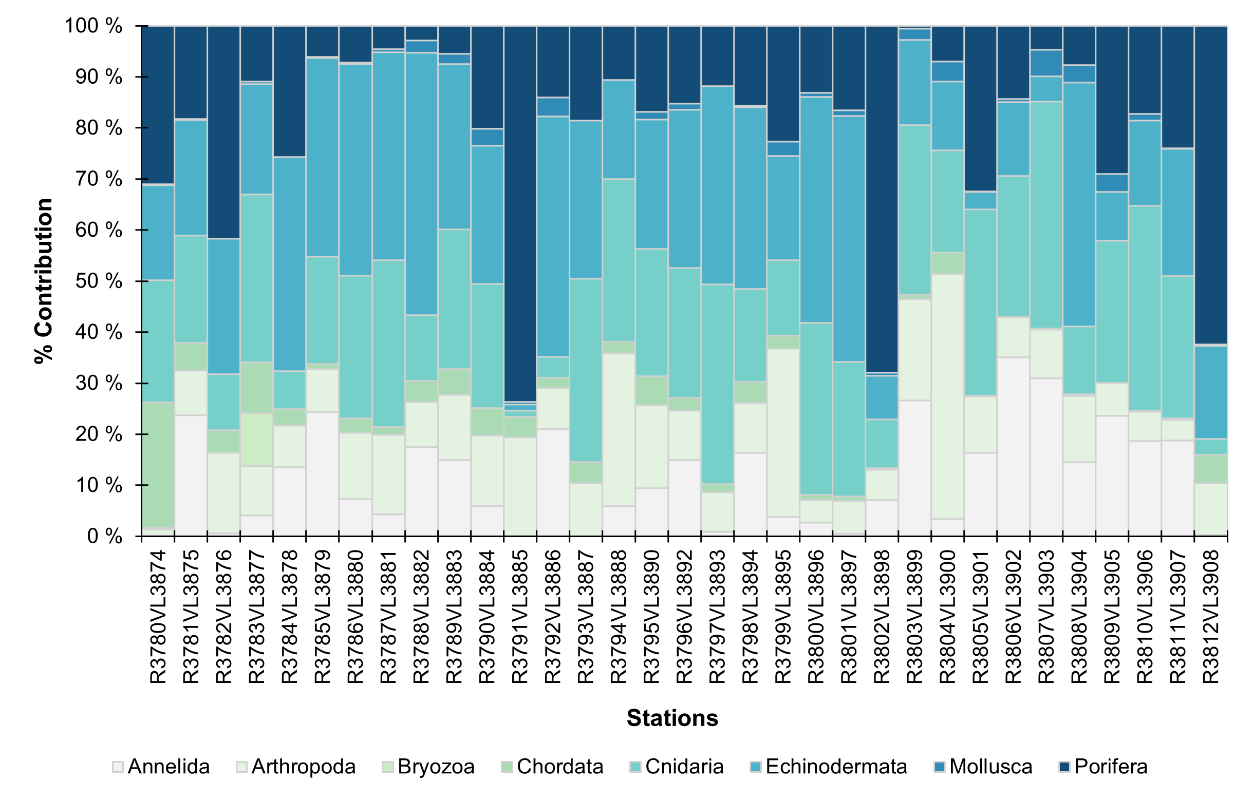
In regards to the general community composition trends logged in SFO (Figure 8), echinoderms were the dominating phyla across most stations, followed by cnidarians, then porifera. Although it must be noted that high frequency of porifera presence were logged in specific stations (e.g. R3791VL3885, R3802VL3898, and R3812VL3908), while otherwise typically contributing relatively little to the general community trends. In NH3-B08, annelids became more frequently logged.
There were a variety of broad habitats logged in SFO in NH3-B07 (Figure 9). The deep basins typically contained stalked fauna on soft bottom, such as sabellid and/or stalked crinoid fields. Shallower flat regions were dominated by Neohela sp. aggregations. The ridges and seamounts in NH3-B07 were primarily dominated by sponge aggregations, with high densities of ophiuroids present. A dense bamboo coral garden or possible reef was logged at the shallower ridge crest (summit approximately 800 m) outside of NH3-B07.

NH3-B08 had more homogeneous habitats. In the very deep stations (R3802 and R3805), dense Thenea grounds were observed on the soft bottom. The other deeper basin stations primarily contained habitats with stalked fauna such as sabellid and/or stalked crinoid fields on soft bottom. Only one station observed a hard bottom sponge ground on a steep bedrock wall (R3812).
5.1.2 - Geology
The study areas on this cruise (Figure 10) are the continuation of the previous cruise (2025007011) along the northwestern axis of the mid-ocean spreading ridge. NH3-B07 has a slightly simpler and a bit more subdued landscape, when compared to NH3-B06 from the central part of the rift valley, although it is still characterised by high mountain ridges interspersed by flat-bottomed basins and valleys. Generally, a range of geological processes are active in the area and the geodiversity in the area is high. Especially for seabed morphology and geomorphology, but also with respect to substrate, ranging from very fine grain sizes such as sandy mud to mixed and very coarse grain sizes such as cobbles and boulders. There is also a lot of exposed bedrock in the survey areas, primarily on the mountain ridges and steep inclines.
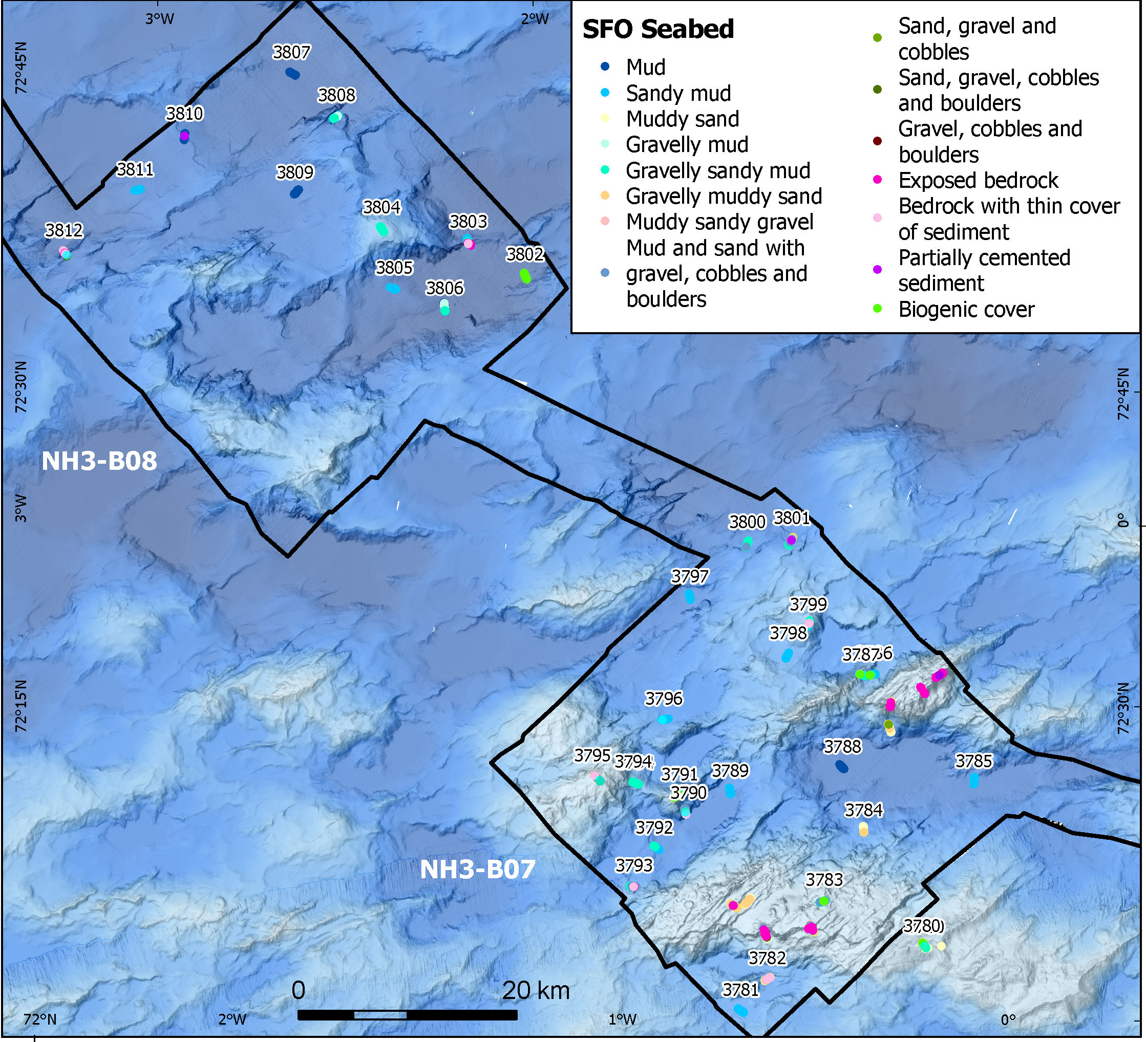
As the distance from the rift valley continues to increase, progressively larger basins are encountered (Figure 10) due to a steadily increasing sediment cover. In NH3-B08 these basins become more prominent and are typically filled with soft sediments—primarily mud and sandy mud—and are characterized by a flat seabed (Figure 11). In some areas, these otherwise flat surfaces are disrupted by slide scars and associated slide deposits.

The sides of slide scars often expose multiple layers of more compacted or partially cemented sediments, along with coarser materials such as gravelly sandy mud or mud and sand containing gravel, cobbles, and boulders. These coarse materials are also commonly found within the slide deposits.
Higher up along the slopes of ridges and seamounts, sediments become increasingly coarse. Gravelly deposits (gravelly sandy mud and muddy sandy gravel) are more common, along with abundant cobbles and boulders (mud and sand with gravel, cobbles, and boulders). The course material mostly originates from nearby bedrock outcrops, which are mainly basaltic in composition.
At the summits of the seamounts, flat areas are covered by gravelly sandy mud and gravelly muddy sand. In contrast, areas of higher relief—such as ridges, faults, and irregular seabed topography—are marked by even coarser materials, including gravelly sediments (gravelly sandy mud, gravelly muddy sand, and muddy sandy gravel), and mud and sand with gravel, cobbles and boulders, as well as exposed bedrock outcrops. On this cruise both the bedrock exposures and loose rocks have displayed a gradual increase of encrustation, likely consisting of manganese-rich precipitates, with some samples having crusts thicker than 5 cm.
The biogenic cover class—primarily consisting of sponges and spicules but also including bamboo corals—has been observed both in deep basins (NH3-B08) and on the summits of seamounts and ridges (NH3-B07). This class is used where organisms are either completely dominating or obscuring the view of the sea floor.
5.1.3 - Chemistry
Seven push cores have been collected at each of the four full stations (R3785, R3796, R3802, and R3809), and in addition at the aborted full station (R3807). Five cores of each set were taken with plastic tubes, to be analysed for inorganic and organic compounds/contaminants (assigned as cores A and B), XRI core structure analysis (core C), radioactivity measurements (core D) and the last one as a backup (core G). Whereas the two remaining cores (cores E and F) were taken with aluminium tubes and are designated for microplastic analysis. At the full stations R3785 and R3802, samples for emerging contaminants have been taken using blade corers equipped with metal side panels.
5.2 - Full stations
R3785
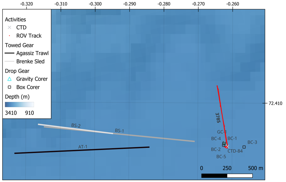
At the first full station, 1 CTD, 5 Box Corers, 1 Gravity Corer, 1 Agassiz Trawl, and 2 Brenke Sleds was taken near the start position of the dive (Figure 12). It took approximately 40 hours to complete from start of the CTD to once the last Brenke Sled was up on deck.
CTD 84
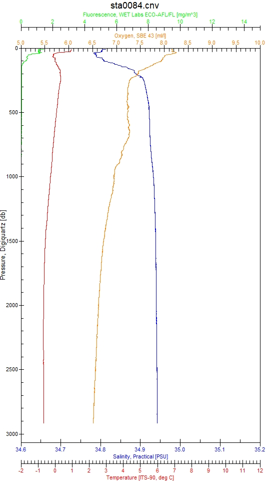
One CTD was taken at this station with bottom water collected for eDNA (Figure 13).
Blade corers – emerging contaminants
Two blade corers (ROV-BL41 and ROV-BL42), equipped with metal side panels, had successfully been deployed to collect samples for the analysis of emerging contaminants (Photo 6).

Push cores
Seven push cores (ROV-PC43 – ROV-PC49) have been collected at station R3785. Five cores have been taken with plastic tubes, to be analysed for inorganic and organic compounds/contaminants (assigned as cores A and B), XRI core structure analysis (core C), radioactivity measurements (core D) and the last one as a backup (core G). Whereas the two remaining cores (cores E and F) were taken with aluminium tubes, designated for microplastic analysis.
Box corer 1-5
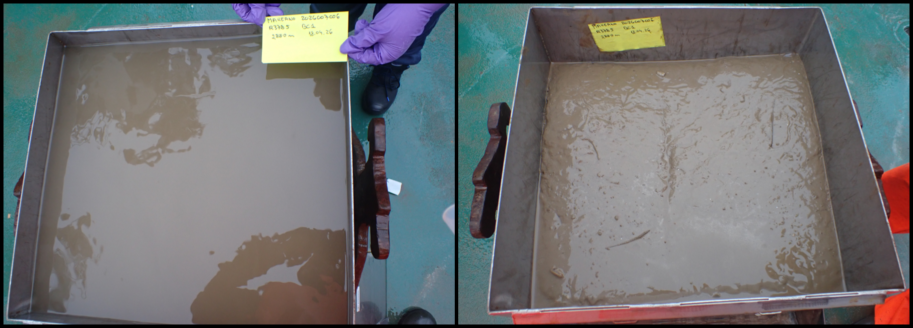
Box core #: 1 Box Core Area (m2): 0.25 Sample Quality: Quantitative Date and Time (UTC): 18.04.2026 04:24:30 Latitude and Longitude (DD): 72.4065, -0.2623 Start Depth (m): 2879.9 Waveheight (m): 2.5
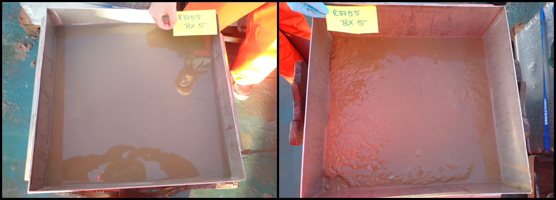
Short summary: Box core did not deploy on impact but was released by ROV. Might have been slightly disturbed. Surface well preserved. 1 x sediment pigment sample (2 cm surface) and 2 x replicates for sediment eDNA taken.
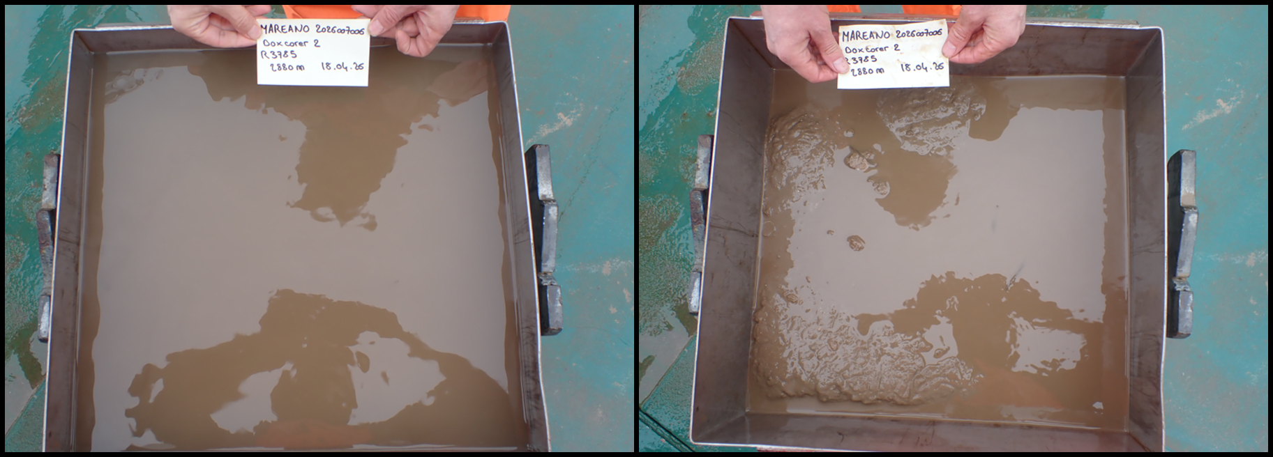
Box core #: 2 Box Core Area (m2): 0.25 Sample Quality: Quantitative Date and Time (UTC): 18.04.2026 07:21:22 Latitude and Longitude (DD): 72.4064, -0.2623 Start Depth (m): 2881.4 Waveheight (m): 1.8
Short summary: ROV video did not record landing, but watching it live it was confirmed a good landing and box corer released properly. Sediment surface irregular, difficult to remove overlaying water complete. 1 x sediment pigment sample (2 cm surface) and 2 x replicates for sediment eDNA taken.
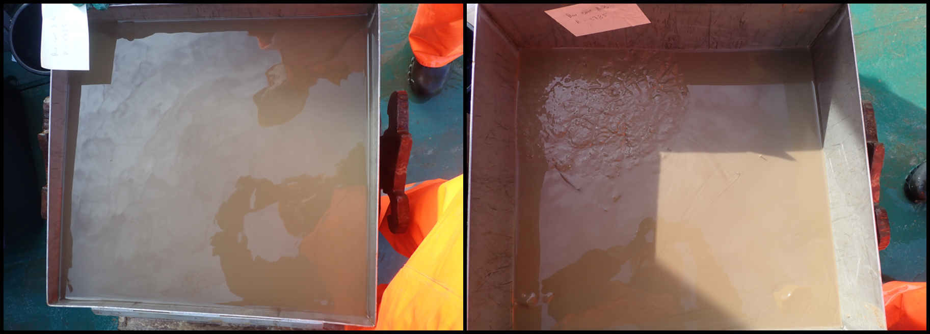
Box core #: 3 Box Core Area (m2): 0.25 Sample Quality: Quantitative Date and Time (UTC): 18.04.2026 12:26:33 Latitude and Longitude (DD): 72.4062, -0.2565 Start Depth (m): 2881.5 Waveheight (m): 1.5
Short summary: Box corer landed close to previous holes. Sediment surface very irregular and difficult to remove all overlaying water. 1 x sediment pigment sample (2 cm surface) and 2 x replicates for sediment eDNA taken.
Box core #: 4 Box Core Area (m2): 0.25 Sample Quality: Quantitative Date and Time (UTC): 18.04.2026 14:57:26 Latitude and Longitude (DD): 72.4065, -0.2623 Start Depth (m): 2880.6 Waveheight (m): 2.2
Short summary: Good landing, although needed release with the ROV. ROV video not recorded but checked live. 1 x sediment pigment sample (2 cm surface) and 2 x replicates for sediment eDNA taken.
Box core #: 5 Box Core Area (m2): 0.25 Sample Quality: Quantitative Date and Time (UTC): 18.04.2026 17:07:32 Latitude and Longitude (DD): 72.4063, -0.2625 Start Depth (m): 2880.2 Waveheight (m): 1.5
Short summary: Landed but box corer did not release. Moved about 10 m away from first landing and box corer was released with ROV. Surface more regular. 1 x sediment pigment sample (2 cm surface) and 2 x replicates for sediment eDNA taken.
Gravity corer 1
Gravity Core ID: KPH26-706-GC01 Date and Time (UTC): 18.04.2026 10:06:56 Latitude and Longitude (DD): 72.4065, -0.2622 Start Depth (m): 2881.0 Length (m): 3.53
Short summary: 4 sections: A (0-100 cm), B (100-200 cm), C (200-270 cm), D (270-353 cm)
Agassiz trawl 1
Agassiz Trawl 1 was deployed for 37.7 minutes of effective bottom trawling at a starting depth of approximately 2900.4 m and ending depth of 2890.4 m (Figure 14 and 15; Appendix 3). During the towing, the gear maintained stable bottom contact with only minor depth variability between 2890 and 2900 m. Wire out at bottom contact was 3521 m, corresponding to a wire-depth ratio of 1.2. The estimated smoothed trawled distance and trawled linear distance was 1336.4 m and 1308.6 m, respectively. The swept area was 2926.8 m², representing the largest swept area among the four Agassiz trawls.


Agassiz trawl 1 yielded sample of ~ 50-60 L with mud (Photo 7). The catch was characterized by a relatively even faunal composition, with the sea cucumber Kolga sp. as the dominant taxon. Other common taxa comprised molluscs (Buccinidae indet.), cnidarians (primarily cf. Bathyphellia sp.), poriferans (mainly Polymastiidae indet. and Thenea sp.), echinoderms (Pourtalesia sp., Bathycrinus carpenterii), annelids (Sabellidae indet.), and pycnogonids. Less common fauna were arthropods (amphipods, mysids, Bythocaris sp., and Saduria sp.), and Asteroidea. Fish collected in the trawl included seven Lycodes frigidus (0.503 kg).

Brenke sledge 1 and 2
Brenke Sled 1 was towed for 71.8 minutes of effective towing at the bottom with a starting depth of approximately 2824.8 m and ending depth of 2823.3 m (Figure 16 and 17; Appendix 4). Wire out at bottom contact was 2911.7 m, corresponding to a wire-depth ratio of approximately 1.0. The estimated smoothed towed distance and towed linear distance was 1468.0 m and 1487.4 m, respectively. The area swept and volume swept were 1487.4 m² and 520.6 m3, representing the largest swept area among the five Brenke Sleds. However, it was realized once the Brenke Sled was on deck that it was not rigged correctly because the doors were open upon retrieval and another Brenke Sled was deployed. The sample was therefore invalid.

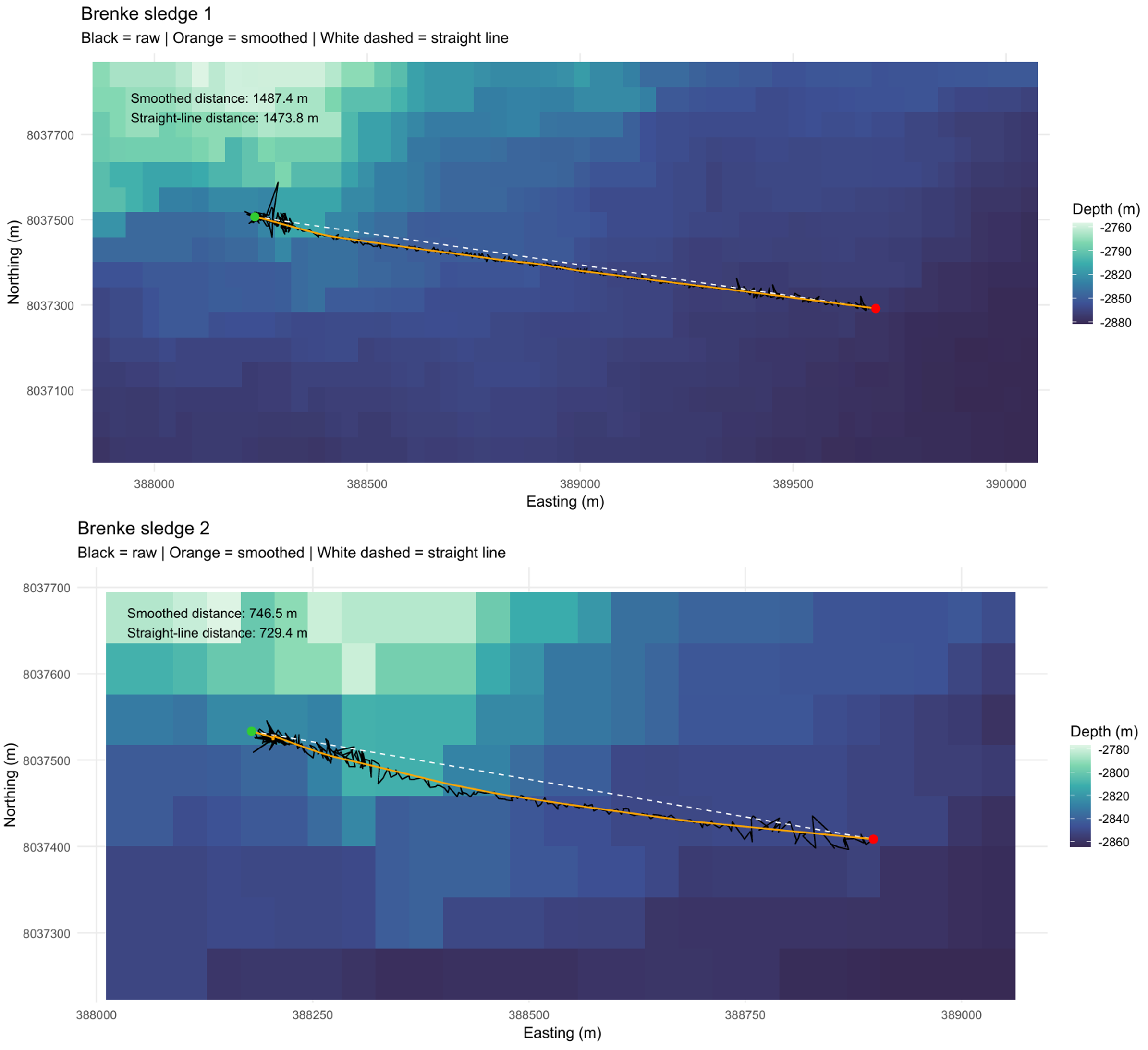
Brenke Sled 2 was towed for 49.3 minutes of effective towing at the bottom with a starting depth of approximately 2800.6 m and ending depth of 2802.8 m. Wire out at bottom contact was 2875.1 m, corresponding to a wire-depth ratio of approximately 1.0. The estimated smoothed towed distance and towed linear distance was 746.5 m and 426.6 m, respectively. The area swept and volume swept were 746.5 m² and 261.3 m3. The sample in supranet measured to 40 cm and the Epinet sample measured to 70 cm. Both cod ends were full.
R3796
At the second full station, 1 CTD was taken at the start position of the dive and 2 Box Corers, 2 Gravity Corer, 1 Agassiz Trawl, and 1 Brenke Sled were taken near the stop position of the dive (Figure 18). It took approximately 29 hours to complete from start of the CTD to once the Brenke Sled was up on deck.
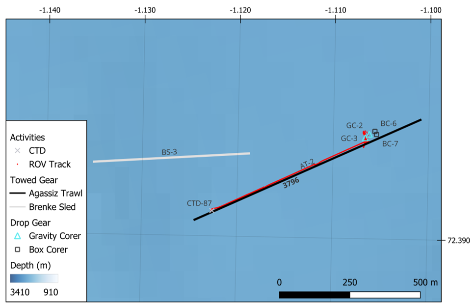
CTD 87
One CTD was taken at this station with bottom water collected for eDNA (Figure 19).

Push cores
Seven push cores (ROV-PC110 – ROV-PC116) have been collected at station R3796. Five cores have been taken with plastic tubes, to be analysed for inorganic and organic compounds/contaminants (assigned as cores A and B), XRI core structure analysis (core C), radioactivity measurements (core D) and the last one as a backup (core G). Whereas the two remaining cores (cores E and F) were taken with aluminium tubes, designated for microplastic analysis.
Box corer 6-7
Box core #: 6 Box Core Area (m2): 0.25 Sample Quality: Quantitative Date and Time (UTC): 22.04.2026 09:35:32 Latitude and Longitude (DD): 72.3934, -1.1057 Start Depth (m): 2521.2 Waveheight (m): 1.0
Short summary: Successfully released. However, it bounced slightly at the bottom before landing again and surface might have been slightly disturbed. Good surface, well preserved. 1 Porifera and Antedonoidea indet. Sticky clay. 1 x sediment pigment sample (2 cm surface) and 2 x replicates for sediment eDNA taken.
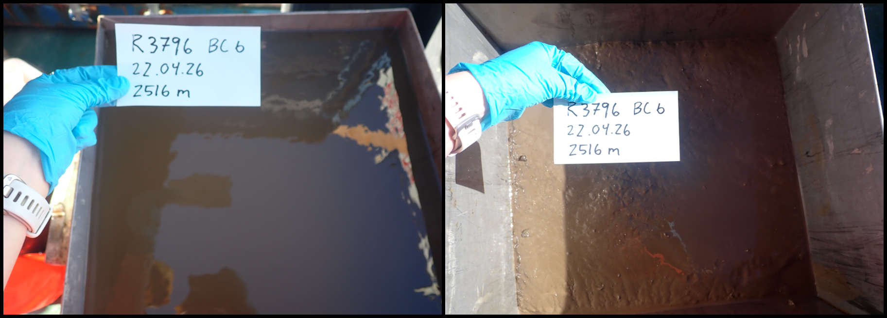
Box core #: 7 Box Core Area (m2): 0.25 Sample Quality: Quantitative Date and Time (UTC): 22.04.2026 11:33:26 Latitude and Longitude (DD): 72.3933, -1.1055 Start Depth (m): 2521.3 Waveheight (m): 1.4
Short summary: Very good and controlled landing. Well preserved surface. A bit watery. 1 x sediment pigment sample (2 cm surface) and 2 x replicates for sediment eDNA taken.
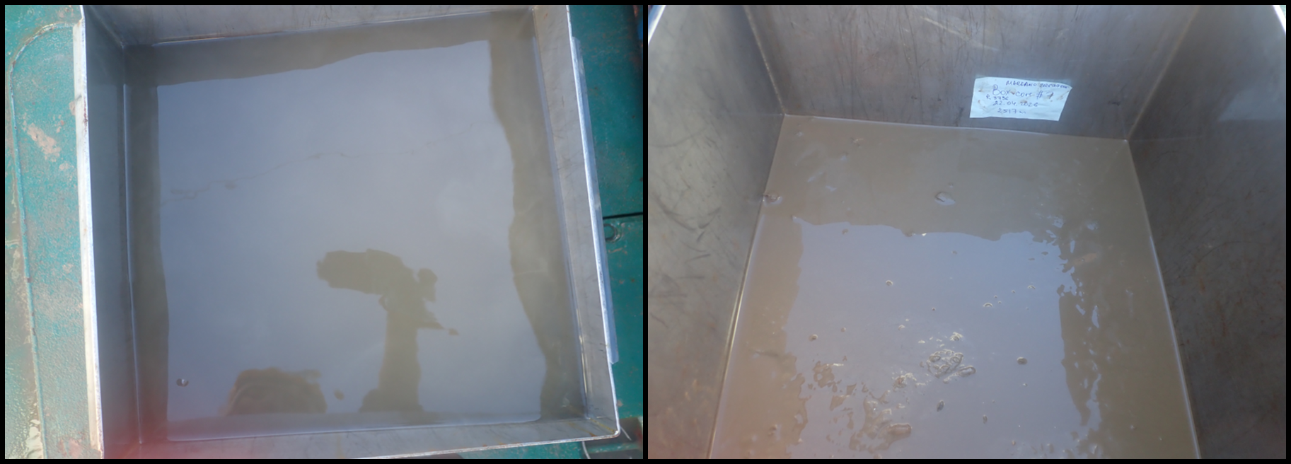
Gravity corer 2-3
Gravity Core ID: KPH26-706-GC02 Date and Time (UTC): 22.04.2026 13:43:49 Latitude and Longitude (DD): 72.3933, -1.1062 Start Depth (m): 2520.5 Length (m): NA
Short summary: Wire caught on the head, hindering a proper retrieval of the gravity corer. ROV helped untangling the wire, but sample was disturbed/destroyed when GC was put into seabed again (to make untangling easier and safe), causing a “secondary sampling” in the same core. Core liner was flushed and reused at a next full station.
Gravity Core ID: KPH26-706-GC03 Date and Time (UTC): 22.04.2026 16:41:28 Latitude and Longitude (DD): 72.3932, -1.1067 Start Depth (m): 2520.2 Length (m): 3.40
Short summary: 4 sections: A (0-100 cm), B (100-200 cm), C (200-270 cm), D (270-340 cm)
Agassiz trawl 2
Agassiz Trawl 2 was conducted for 27.9 minutes at the shallowest depth among the four trawls, starting at 2554.9 m and ending at 2534.7 m (Figure 20 and 21; Appendix 3). Bottom contact remained stable throughout the deployment, with depth variability between 2535 and 2555 m. The wire length at bottom contact was 3086 m, corresponding to a wire-depth ratio of 1.2. The estimated smoothed trawled distance and trawled linear distance was 886 m and 868.7 m, respectively. The estimated swept area was 1941.3 m².
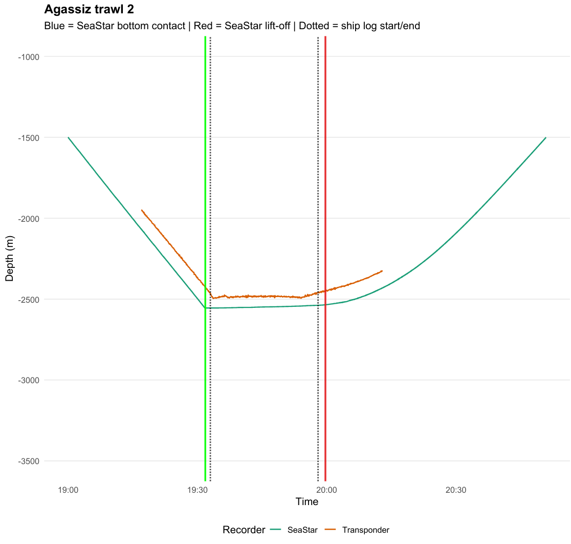
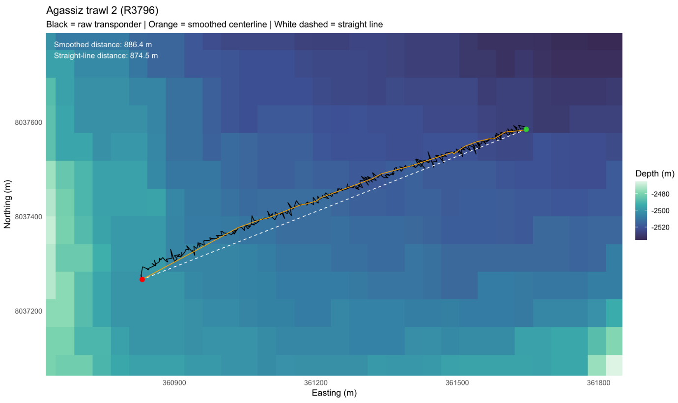
Agassiz Trawl 2 yielded a sample volume of approximately 40-50 L including mud (Photo 8). The most common taxon were poriferans, particularly Thenea sp., together with bivalves, likely cf. Hyalopecten sp. Other common fauna comprised gastropods (Buccinidae indet.), echinoderms (Kolga sp., Pourtalesia sp., Hymenaster sp., Bathycrinus carpenterii), cnidarians (mainly cf. Bathyphellia sp. frequently attached to stones and shells), and arthropods including pycnogonids, amphipods, mysids, and Bythocaris sp. Less common fauna included Sabellidae indet., dead colonies of bryozoans, Tylaster sp., and unstalked crinoids. Eight individuals of Lycodes frigidus (0.875 kg) were collected in the trawl.

Brenke sledge 3
Brenke Sled 2 was towed for 13.7 minutes of effective towing at the bottom with a starting depth of approximately 2460.3 m and ending depth of 2461.7 m (Figure 22 and 23; Appendix 4). Wire out at bottom contact was 2830.2 m, corresponding to a wire-depth ratio of approximately 1.2. The estimated smoothed towed distance and towed linear distance was 561.9 m and 546.3m, respectively. The area swept and volume swept were 561.9 m² and 196.7m3. The sample in supranet measured to 7.5 cm in the cod-end with nothing in the net, and the Epinet sample measured to 20 cm in the cod-end to approximately 4 cm in the net. Sample consisted of large and small crustaceans, Kolga sp., and porifera.
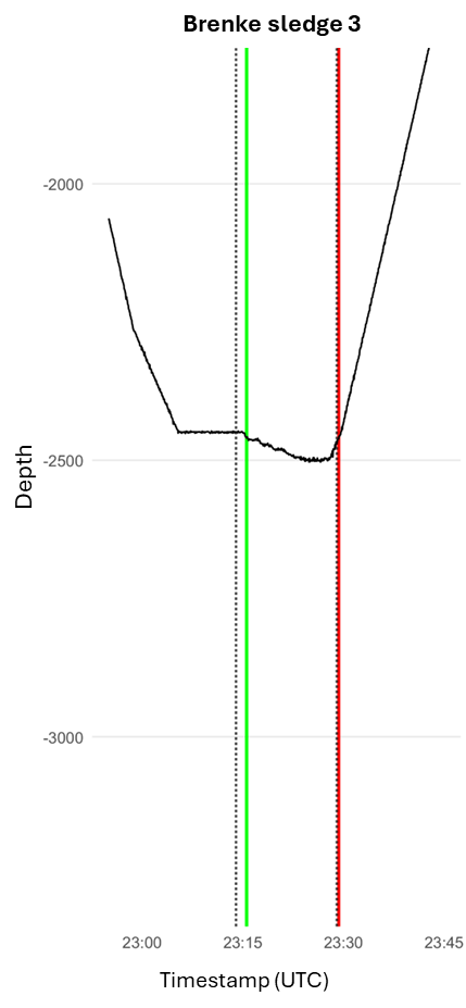
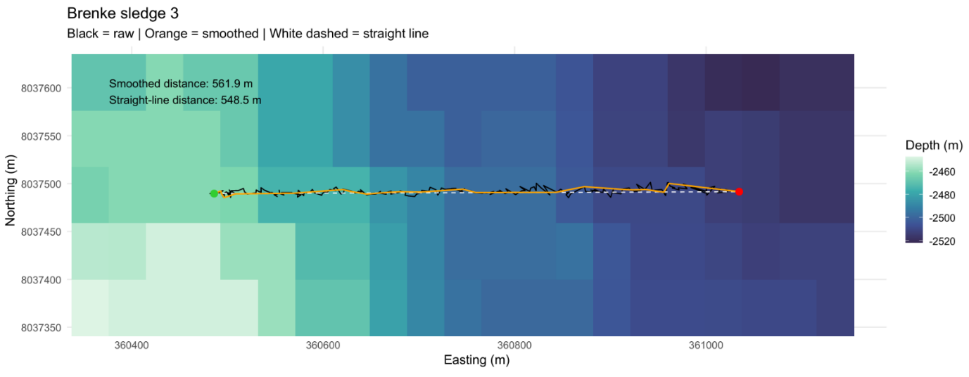
R3802
At the third full station, 2 CTDs, 2 Box Corers, 1 Gravity Corer, 1 Agassiz Trawl, and 1 Brenke Sled was taken near the start position of the dive (Figure 24). It took approximately 28 hours to complete from start of the ROV to once the Brenke Sled was up on deck.

CTD 88 and 89
Two CTDs were taken at this station with bottom water collected for eDNA only at CTD 89 (Figure 25). The first one was taken here because it was thought that this station would not be a full station, therefore no bottom water was collected for eDNA. However, once it was decided that R3802 would be a full station, a second CTD was deployed to collect bottom water after the ROV dive was completed.
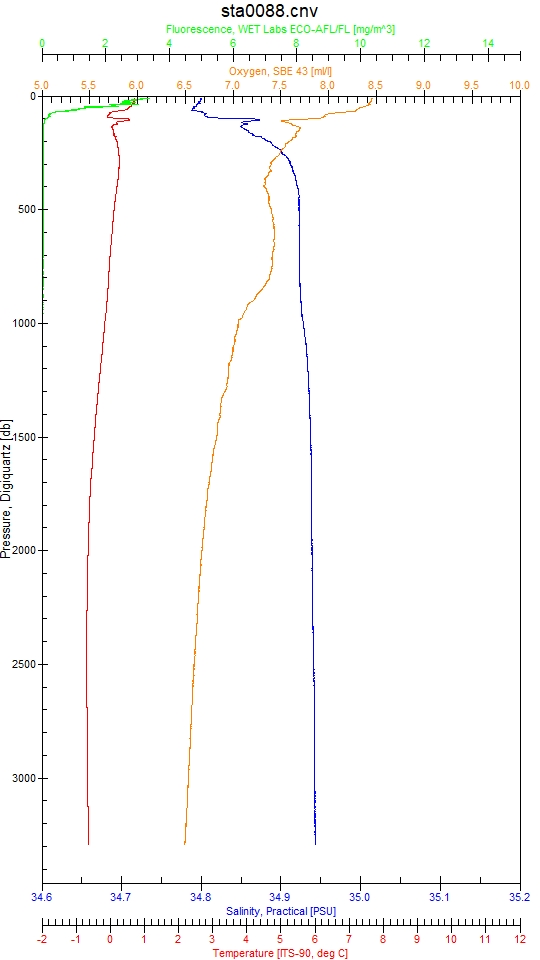

Blade corers – emerging contaminants
Two blade corers (ROV-BL149 and ROV-BL150), equipped with metal side panels, had successfully been deployed to collect samples for the analysis of emerging contaminants (Photo 9). The blade corers were somewhat overfilled with the sediment surface being above the joint of the two side panel sections. However, due to the careful unscrewing/opening of the side panel, the surface water ran off slowly without significantly disturbing the sediment surface.
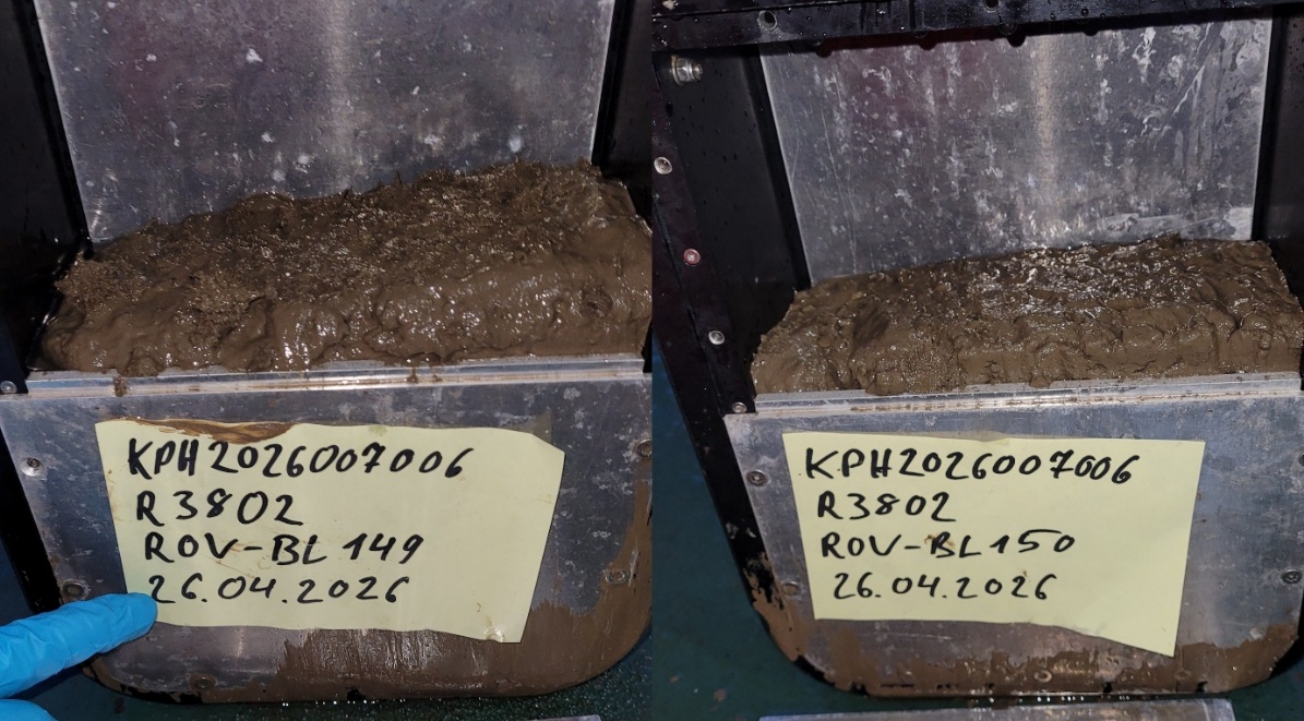
Push cores
Seven push cores (ROV-PC142 – ROV-PC148) have been collected at station R3802. Five cores have been taken with plastic tubes, to be analysed for inorganic and organic compounds/contaminants (assigned as cores A and B), XRI core structure analysis (core C), radioactivity measurements (core D) and the last one as a backup (core G). Whereas the two remaining cores (cores E and F) were taken with aluminium tubes, designated for microplastic analysis.
Box corer 8-9
Box core #: 8 Box Core Area (m2): 0.25 Sample Quality: Quantitative Date and Time (UTC): 27.04.2026 03:49:25 Latitude and Longitude (DD): 72.7126, -1.8170 Start Depth (m): 3241.3 Waveheight (m): 1.6
Short summary: Nice landing, smooth. Lots of Porifera (Thenea sp.). 1 x sediment pigment sample (2 cm surface) and 2 x replicates for sediment eDNA taken.
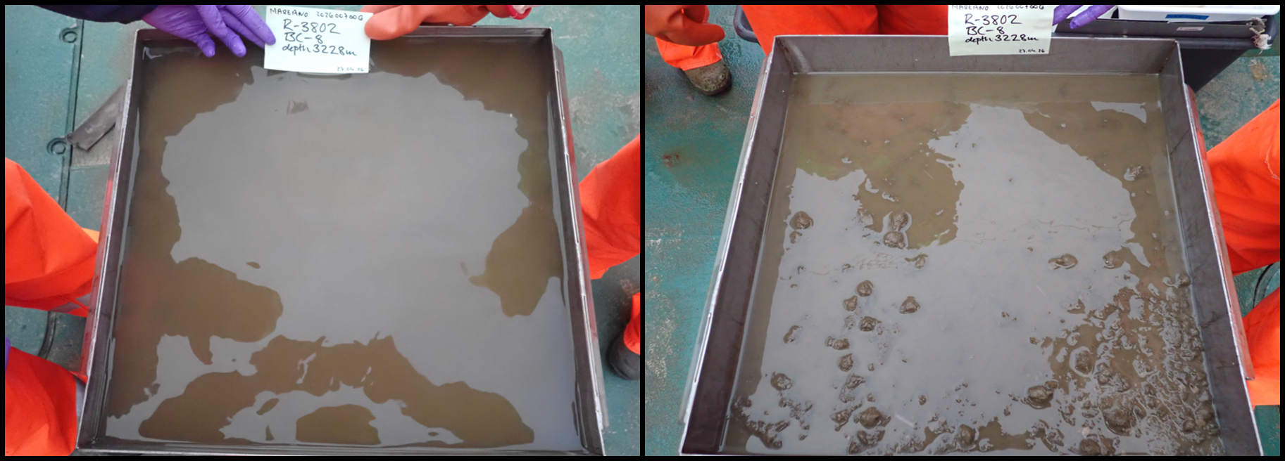
Box core #: 9 Box Core Area (m2): 0.25 Sample Quality: Quantitative Date and Time (UTC): 27.04.2026 06:05:57 Latitude and Longitude (DD): 72.7128, -1.8169 Start Depth (m): 3242.2 Waveheight (m): 1.6
Short summary: Perfect soft landing. Lots of Porifera (Thenea sp.). 1 x sediment pigment sample (2 cm surface) and 2 x replicates for sediment eDNA taken.
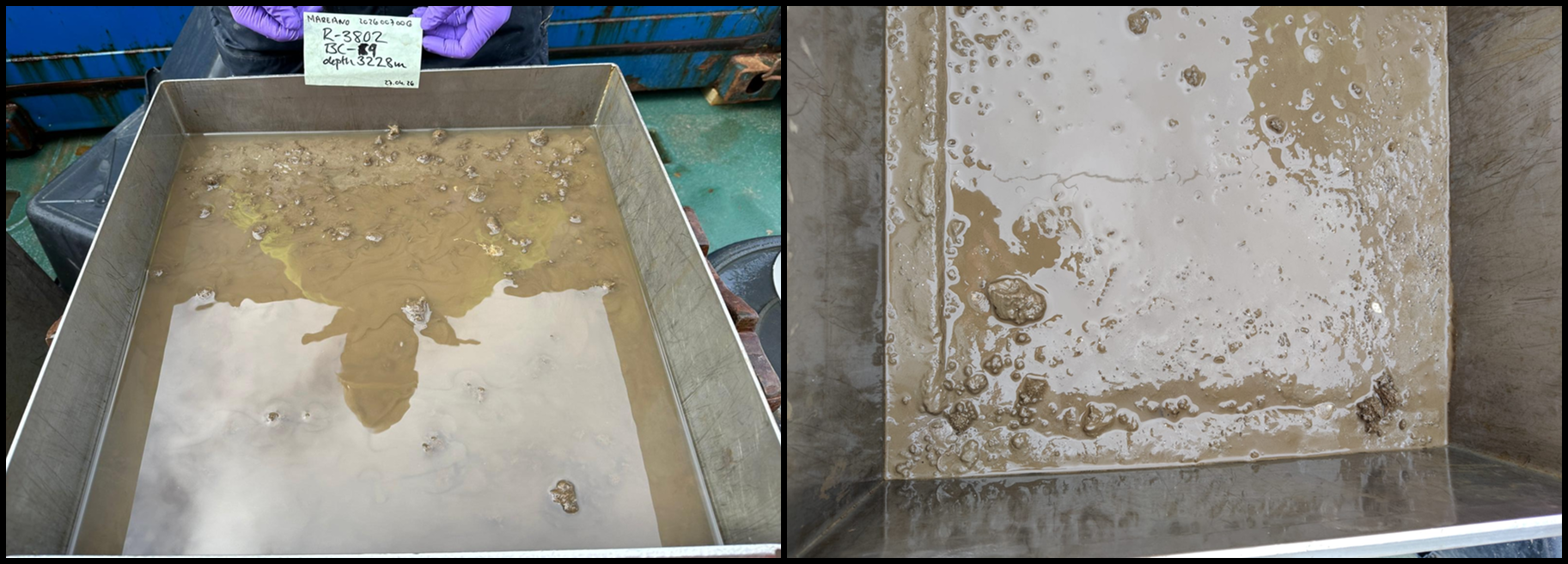
Gravity corer 4
Gravity Core ID: KPH26-706-GC04 Date and Time (UTC): 27.04.2026 08:36:15 Latitude and Longitude (DD): 72.7135, -1.8168 Start Depth (m): 3250.7 Length (m): 3.99
Short summary: 4 sections: A (0-100 cm), B (100-200 cm), C (200-300 cm), D (300-399 cm)
Agassiz trawl 3
Agassiz Trawl 3 was deployed for 26 minutes of bottom trawling and represented the deepest Agassiz deployment of the survey at approximately 3280 m depth (Figure 26 and 27, Appendix 3). Wire out at bottom contact was 3782.7 m, maintaining the wire-depth ratio of 1.2. Bottom depth remained stable between 3270 and 3280 m during towing. This deployment produced the smallest estimated smoothed trawled distance (726 m) and swept area (1591.4 m²) among the four trawls.
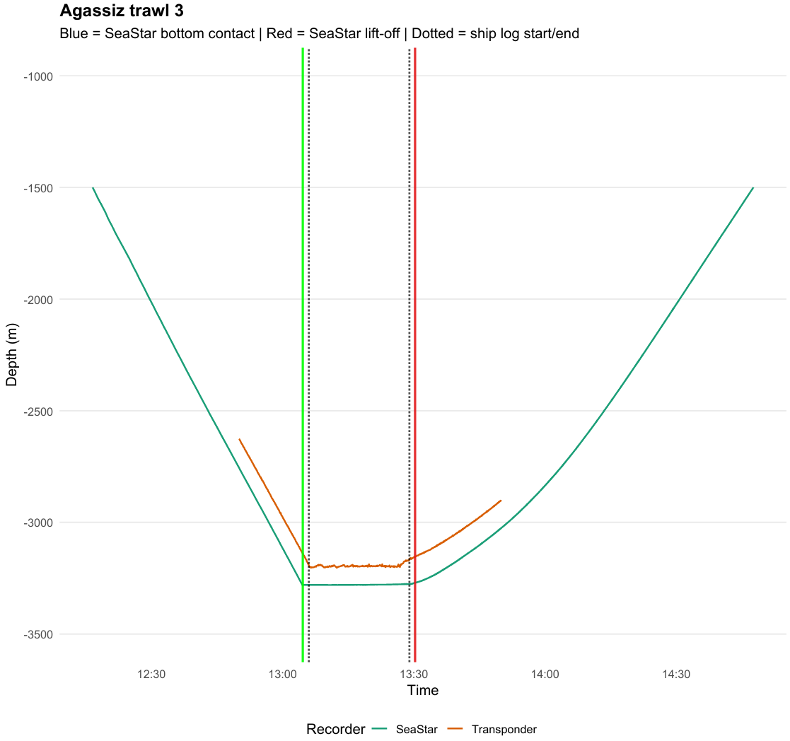

Agassiz Trawl 3 yielded approximately 50 L of sample including mud and was strongly dominated by Thenea sp sponges (Photo 10). Other fauna present in the sample included echinoderms (Tylaster sp. and Bathycrinus carpenterii), cnidarians (mainly cf. Bathyphellia sp.), arthropods including pycnogonids, amphipods (e.g., Stegocephalidae indet. and Themisto sp.), isopods (Saduria sp.), mysids, and Bythocaris sp., as well as annelids (mainly tube worms belonging mainly to Ampharetidae, Sabellidae, and Serpulidae), and other poriferans.
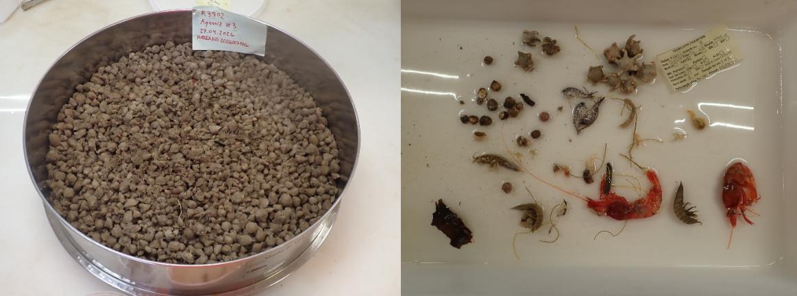
Brenke sledge 4
Brenke Sled 4 was towed for 36.2 minutes of effective towing at the bottom with a starting depth of approximately 3212.0 m and ending depth of 3199.8 m (Figure 28 and 29; Appendix 4). Wire out at bottom contact was 3289.5 m, corresponding to a wire-depth ratio of approximately 1.0. The estimated smoothed towed distance and towed linear distance was 604.3 m and 574.4 m, respectively. The area swept and volume swept were 604.3 m² and 211.5 m3. The sample was dominated by Thenea sp. The supranet to 15.5 cm in the cod-end with only spicules in the net. There were a lot of Thenea sp., pycnogonids, and Ampharete sp. polychaetes in the heavy fraction. The Epinet sample measured to 15 cm in the cod-end. The net consisted of mostly Thenea sp., some crustaceans, Calanus sp. and Chaetognatha. The heavy fraction consisted of Thenea sp., pycnogonids, and Sabellidae tubes.
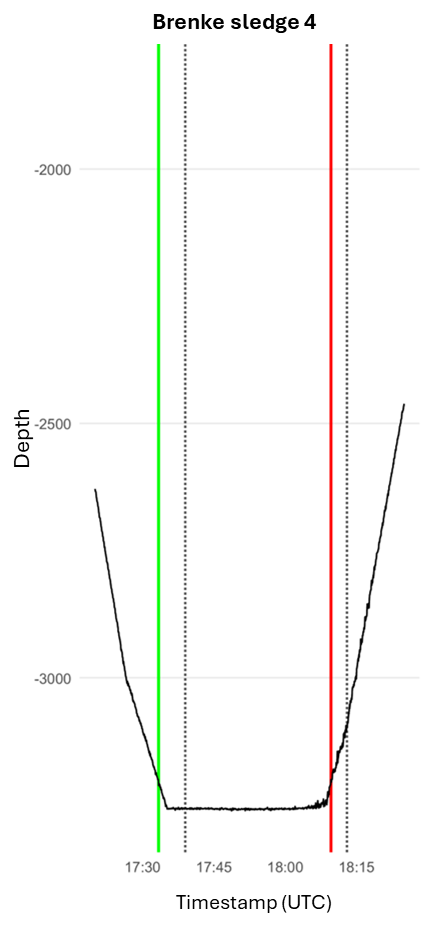

R3807 – Aborted
At R3807, 1 CTD and 2 Box Corers were taken near the start position of the dive, then further sampling was stopped when it was decided to abort the full station (Figure 30). It took approximately 13 hours from start of the ROV to once the second box corer was up on deck. This full station was aborted due to it being unsuitable for the gear due to the sediment consistency.
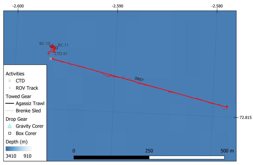
CTD 91
One CTD was taken at this station with bottom water collected for eDNA (Figure 31).
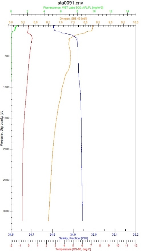
Push cores
Seven push cores (ROV-PC173 – ROV-PC179) have been collected at station R3807. Five cores have been taken with plastic tubes, to be analysed for inorganic and organic compounds/contaminants (assigned as cores A and B), XRI core structure analysis (core C), radioactivity measurements (core D) and the last one as a backup (core G). Whereas the two remaining cores (cores E and F) were taken with aluminium tubes, designated for microplastic analysis. During disassembly of the push corers and securing the samples, we experienced unexpected difficulties with sediment sliding out of the tubes, which we could late attribute to the unusual, pudding-like consistency of the sediments.
Box corer 10-11
Box core #: 10 Box Core Area (m2): 0.25 Sample Quality: Discarded Date and Time (UTC): 29.04.2026 05:54:57 Latitude and Longitude (DD): 72.8169, -2.5965 Start Depth (m): 3110.0 Waveheight (m): 0.5
Short summary: Very soft sediment. Box corer sank passed the box limit. Flaps could not close due to overfilling. Sample was discarded on deck.
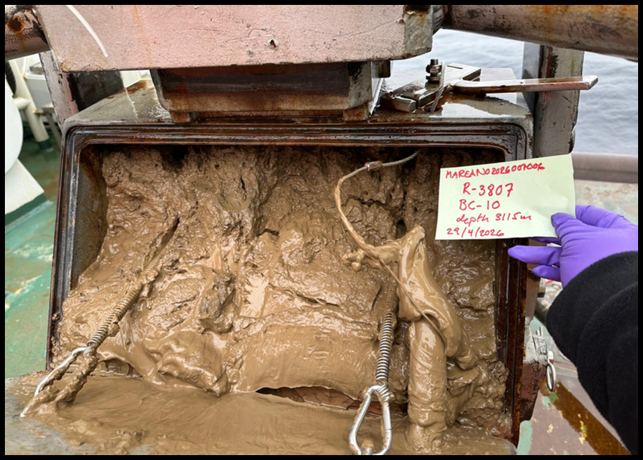
Box core #: 11 Box Core Area (m2): 0.25 Sample Quality: Qualitative Date and Time (UTC): 29.04.2026 08:06:11 Latitude and Longitude (DD): 72.8168, -2.5960 Start Depth (m): 3109.9 Waveheight (m): 0.5
Short summary: Box corer sank too deep in the mud. Very soft sediment. Sample not valid for quantitative purpose. Top layer almost gone, overfilled. Flaps did not close when box corer left the bottom. Any leftover surface fell on the floor on deck when box was removed from the frame. Surface was scooped into a bucket and some more was scooped from the box corer. Sample in bucket was sieved (1, 0.5 and 0.3 mm) for qualitative purposes and fixed in ethanol 96%.
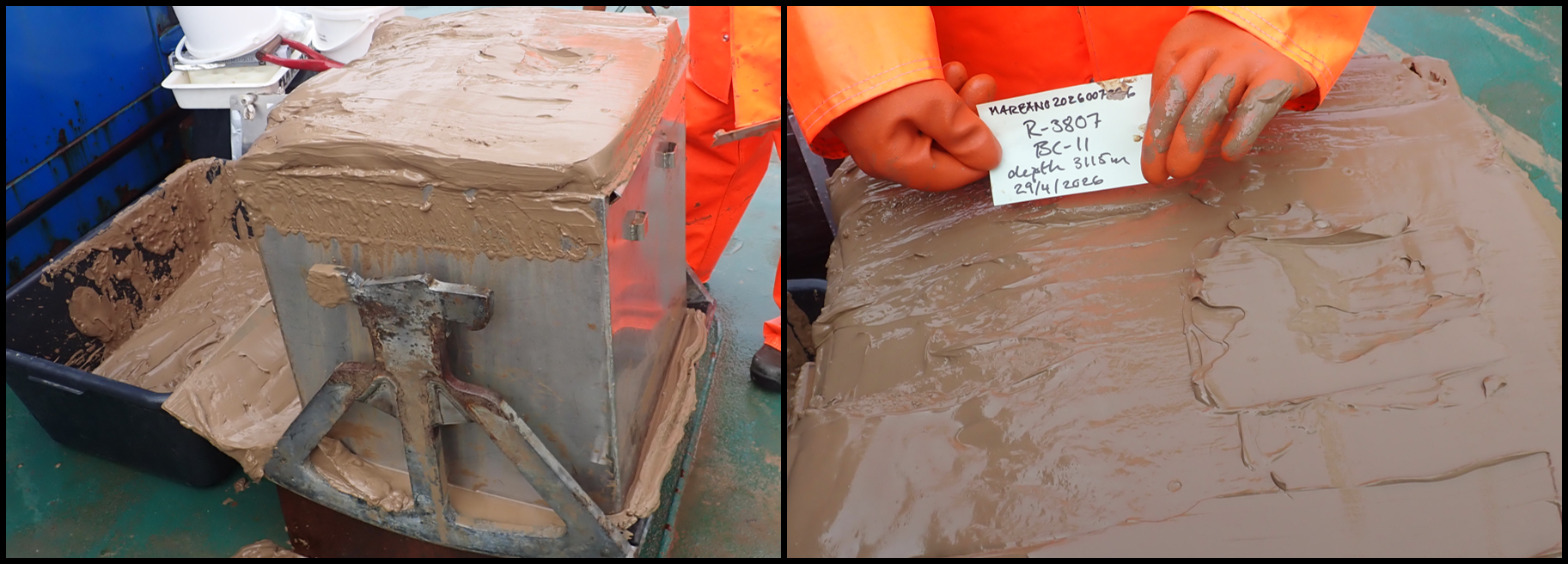
R3809
At the third full station, 1 CTD, 6 Box Corers, 1 Gravity Corer, 1 Agassiz Trawl, and 1 Brenke Sled were taken near the start position of the dive (Figure 32). It took approximately 33 hours from start of the ROV to once the Agassiz trawl was up on deck.
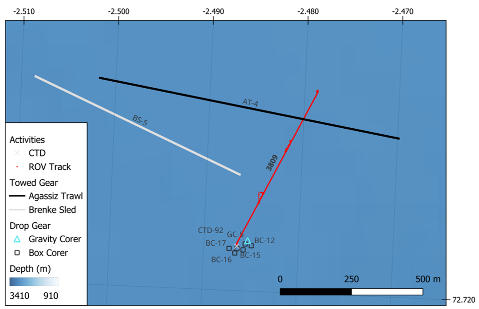
CTD 92
One CTD was taken at this station with bottom water collected for eDNA (Figure 33).
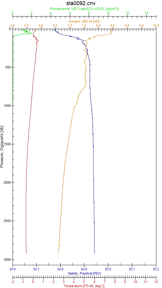
Push cores
Seven push cores (ROV-PC211 – ROV-PC217) have been collected at station R3809. Five cores have been taken with plastic tubes, to be analysed for inorganic and organic compounds/contaminants (assigned as cores A and B), XRI core structure analysis (core C), radioactivity measurements (core D) and the last one as a backup (core G). Whereas the two remaining cores (cores E and F) were taken with aluminium tubes, designated for microplastic analysis.
Box corer 12-17
Box core #: 12 Box Core Area (m2): 0.25 Sample Quality: Quantitative Date and Time (UTC): 30.04.2026 22:11:33 Latitude and Longitude (DD): 72.7214, -2.4850 Start Depth (m): 2884.7 Waveheight (m): 1.0
Short summary: Good landing and good sample. 1 x sediment pigment sample (2 cm surface) and 2 x replicates for sediment eDNA taken.
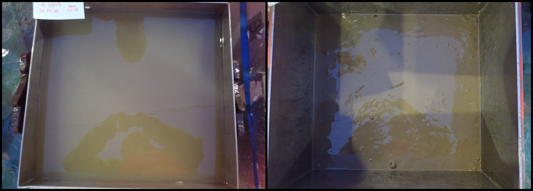
Box core #: 13 Box Core Area (m2): 0.25 Sample Quality: Quantitative Date and Time (UTC): 01.05.2026 00:16:41 Latitude and Longitude (DD): 72.7215, -2.4856 Start Depth (m): 2884.7 Waveheight (m): 1.3
Short summary: Box corer landed heavily into the bottom and did not close. Then landed again and closed. On deck, after removing overlaying water, could see the mark of the first landing. Box core processed, but results should be treated with caution. 1 x sediment pigment sample (2 cm surface) and 2 x replicates for sediment eDNA taken.
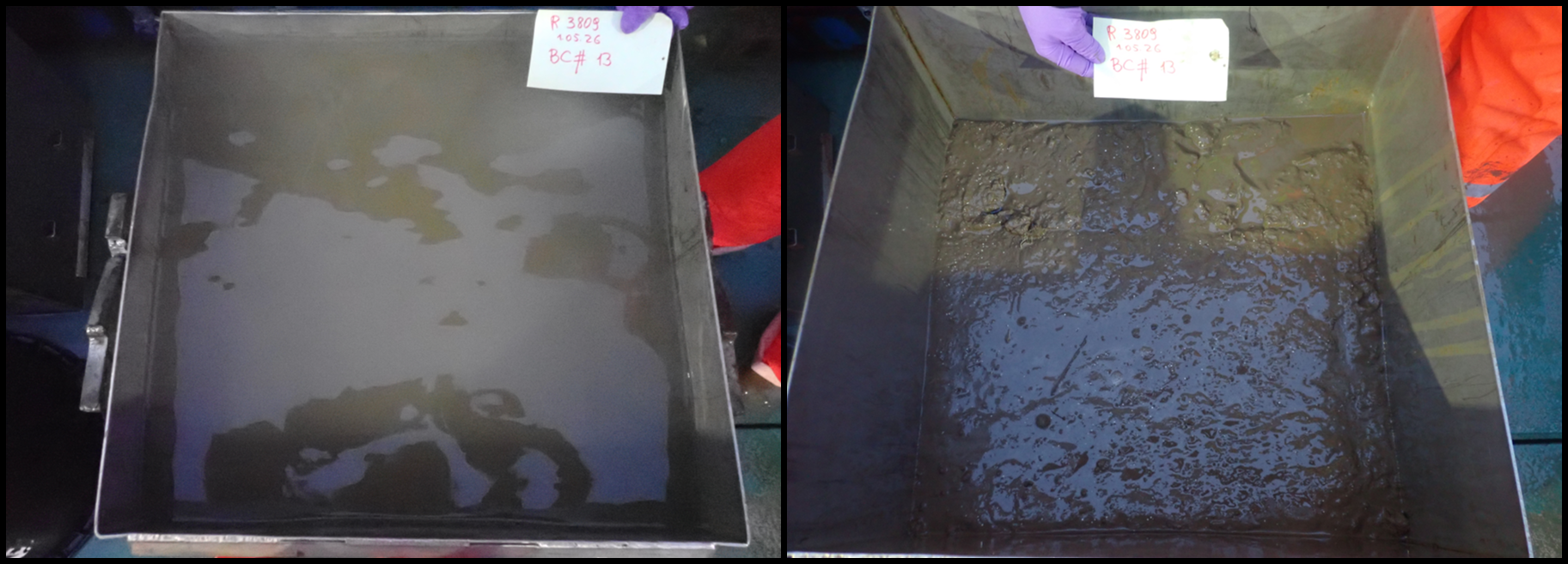
Box core #: 14 Box Core Area (m2): 0.25 Sample Quality: Quantitative Date and Time (UTC): 01.05.2026 05:40:13 Latitude and Longitude (DD): 72.7213, -2.4858 Start Depth (m): 2883.7 Waveheight (m): 1.0
Short summary: Perfect landing. However, box corer banged in the boat. Small mistake placing eDNA tubes but fixed afterwards by taking a new sample. Should not be a problem for analysis. 1 x sediment pigment sample (2 cm surface) and 2 x replicates for sediment eDNA taken.
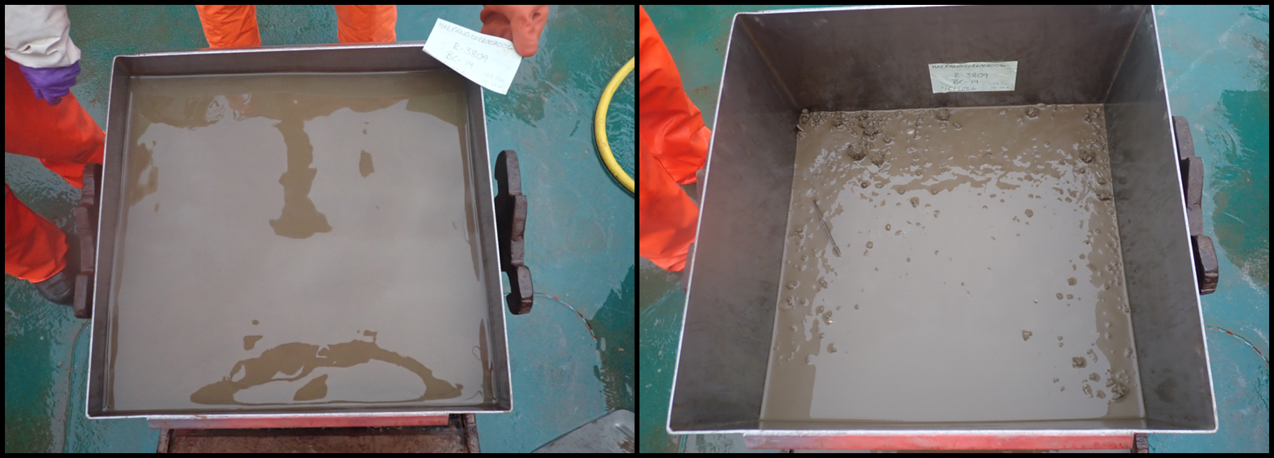
Box core #: 15 Box Core Area (m2): 0.25 Sample Quality: Quantitative Date and Time (UTC): 01.05.2026 07:44:21 Latitude and Longitude (DD): 72.7213, -2.4865 Start Depth (m): 2885.0 Waveheight (m): 1.0
Short summary: Perfect landing. Good sample. 1 x sediment pigment sample (2 cm surface) and 2 x replicates for sediment eDNA taken.
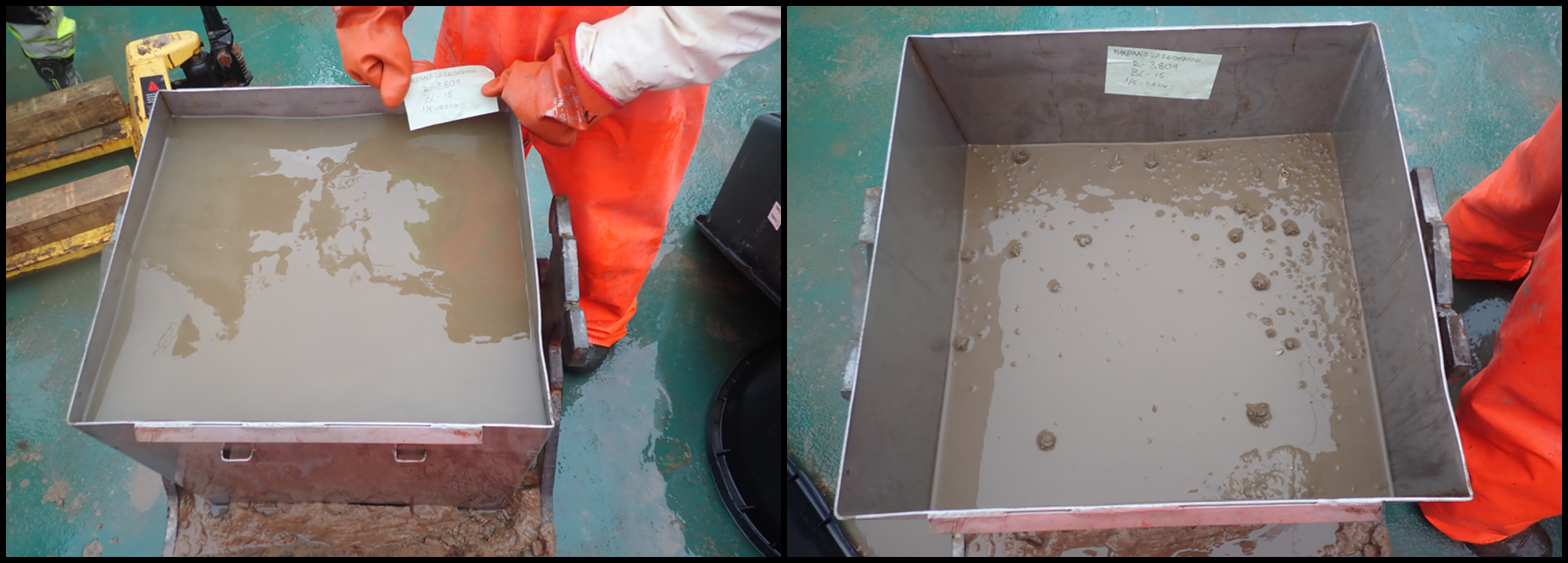
Box core #: 16 Box Core Area (m2): 0.25 Sample Quality: Quantitative Date and Time (UTC): 01.05.2026 09:48:55 Latitude and Longitude (DD): 72.7212, -2.4867 Start Depth (m): 2885.3 Waveheight (m): 1.0
Short summary: Perfect landing. However, box corer did not close and lifted from the bottom open since the shackle of the cable got entangled when pulling the box corer up. However, landed again and got released. Some soft layer might have escaped through the flaps. Interpret results with caution. Sediment surface had a similar mark as box corer #113. 1 x sediment pigment sample (2 cm surface) and 2 x replicates for sediment eDNA taken.
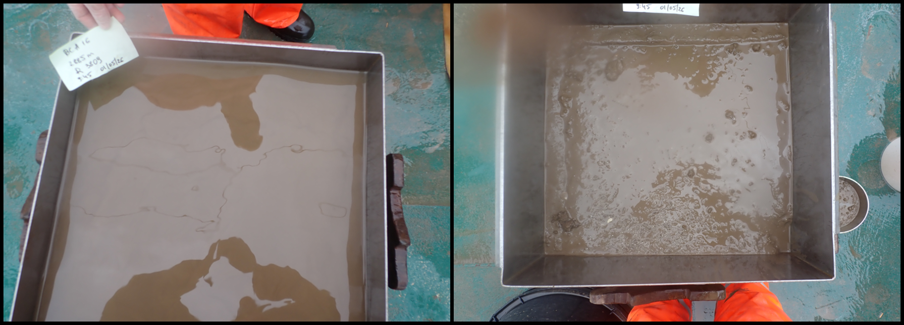
Box core #: 17 Box Core Area (m2): 0.25 Sample Quality: Quantitative Date and Time (UTC): 01.05.2026 11:49:46 Latitude and Longitude (DD): 72.7213, -2.4873 Start Depth (m): 2885.3 Waveheight (m): NA
Short summary: Perfect landing. Good sample. 1 x sediment pigment sample (2 cm surface) and 2 x replicates for sediment eDNA taken.
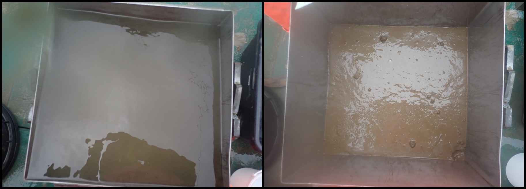
Gravity corer 5
Gravity Core ID: KPH26-706-GC05 Date and Time (UTC): 01.05.2026 03:28:50 Latitude and Longitude (DD): 72.7216, -2.4854 Start Depth (m): 2883.3 Length (m): 4.47
Short summary: 5 sections: A (0-100 cm), B (100-200 cm), C (200-300 cm), D (300-370 cm), E (370-447 cm)
Brenke sledge 5
Brenke Sled 5 was towed for 33.7 minutes of effective towing at the bottom with a starting depth of approximately 2841.1 m and ending depth of 2846.5 m (Figure 34 and 35; Appendix 4). Wire out at bottom contact was 3112.6 m, corresponding to a wire-depth ratio of approximately 1.1. The estimated smoothed towed distance and towed linear distance was 807.4 m and 790.0 m, respectively. The area swept and volume swept were 807.4 m² and 282.6 m3. The supranet cod-end was 3/4 to the way filled. The Epinet cod-end was full and there was 10 cm of sediment in the net. The sample consisted of large amphipods and Thenea sp., with pycnogonids and Bythocaris sp. in the cod-ends.
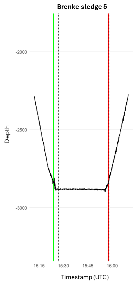
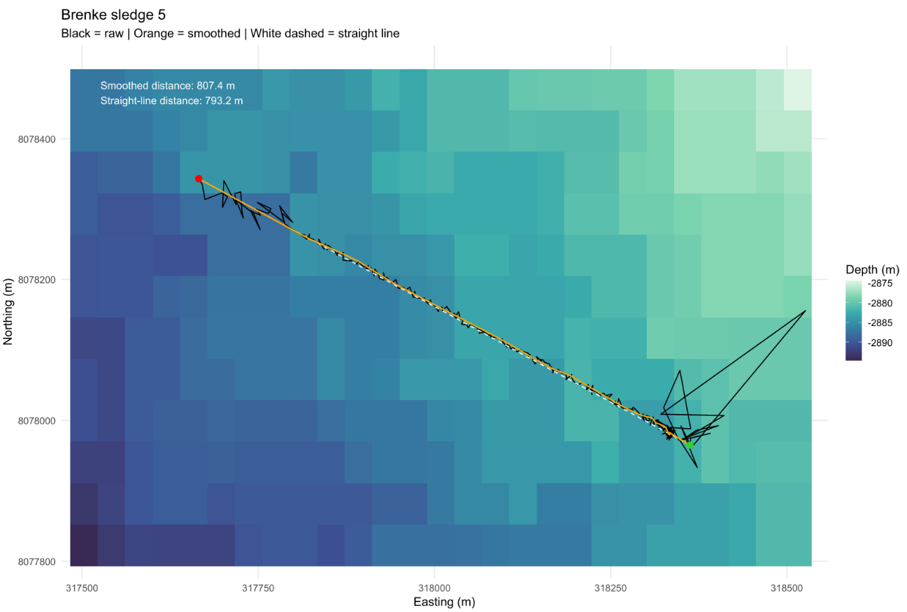
Agassiz trawl 4
Agassiz Trawl 4 (R3809) was conducted for 33 minutes of effective bottom trawling at approximately 2905 m depth (Figures 36 and 37; Appendix 3). Bottom contact remained stable throughout the towing, with only minor depth variation between 2903 and 2908 m. The gear was deployed with 3619 m of wire, corresponding again to a wire-depth ratio of 1.2. The estimated smoothed trawled distance was 1068 m and the swept area was 2338.8 m².
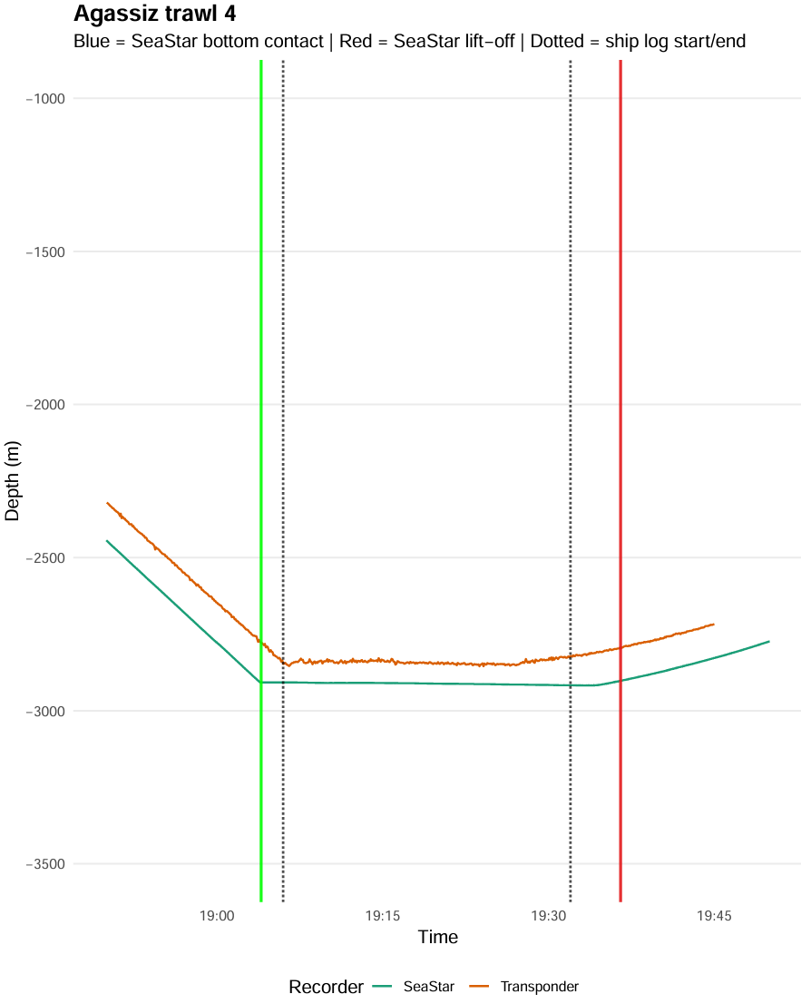
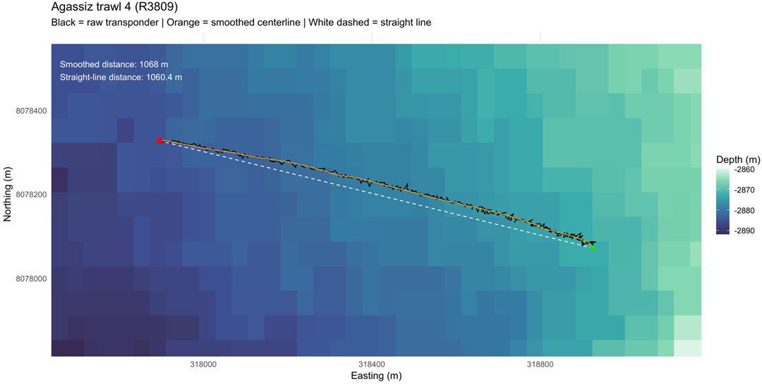
Agassiz Trawl 4 yielded substantially higher volume than other trawls despite only moderate differences in tow duration and swept area and consisted about 210 L with mud. Due the size of the total catch being too large for the complete process, a subsample of 50% has been worked for further semi-quantitative analysis (approximately half from each bucket). Data will be subsequently extrapolated the results to the total catch. The other half of the sample discarded was previously sieved through a 5 mm mesh and briefly screened for rare and interesting taxa.
The semi-quantitative part of the catch was strongly dominated by Thenea sp. sponges (Photo 11). Other fauna collected in the trawl included other poriferans (especially polymasiidae indet.), echinoderms (Kolga sp., Pourtalesia sp., Bathycrinus carpenterii, and much less common Tylaster sp.), molluscs (cf. Hyalopecten sp., Buccinidae indet.), arthropods (pycnogonids, amphipods, Saduria sp., Bythocaris sp.), cnidarians (cf. Bathyphellia sp. and dark purple actiniarians), and annelids (e.g., Sabellidae, Serpulidae, Ampharetidae, Polynoidae). Fish collected in the trawl included three individuals of Lycodes frigidus (0.483 kg). The catch also contained pieces of wood.
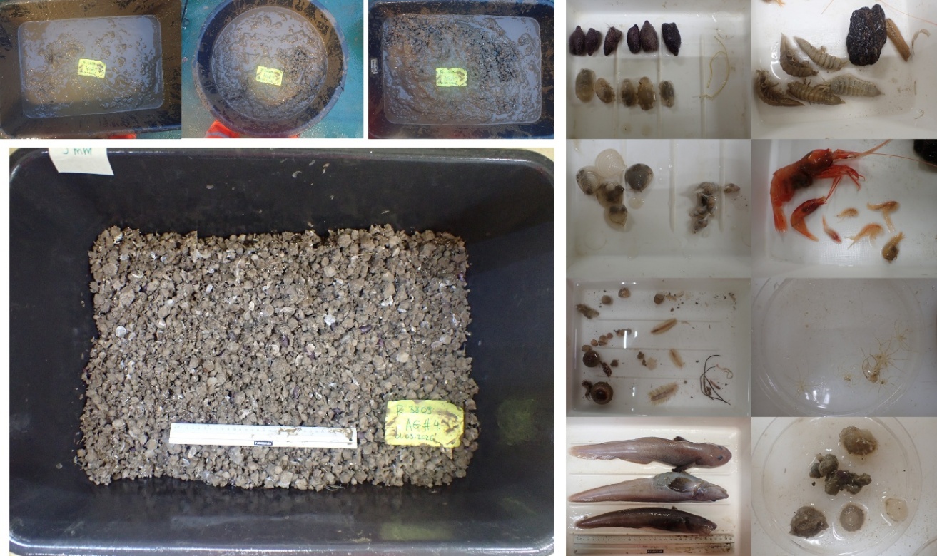
6 - Dive Summary
| Station (Ægir6000 Dive Number) | Box | Start Date & Time (UTC) | VL & Dive Duration (HH:MM) | Start Lat, Long (DD) | Start Depth (m) | # of Samples | Short Summary | Ægir6000 (NORMAR) Picture |
| R3780VL3873 (1110) | Out of NH3-B07 | 16.04.2026 09:10 | 02:46 & 03:20 | 72.2659, -0.2746 | 958 | 3 biology, 2 geology | Landed at a bamboo coral garden with muddy sand and biogenic cover with agglutinated foraminifera. However, due to technical problems with navigation software, the start position was not correct and the dive was aborted. |  20260416103430_4K.jpeg 20260416103430_4K.jpeg |
| R3780VL3874 (1110) | Out of NH3-B07 | 16.04.2026 12:30 | 03:26 & 04:00 | 72.266, -0.2747 | 965 | 5 biology, 2 geology | Seabed started as gravelly muddy sand with some patches of exposed bedrock before turning into primarily biogenic cover/reef-building ridges with agglutinated foraminifera. Alternating bamboo coral garden and reef with some patches of brittle star beds. |  20260416153718_4K.jpeg 20260416153718_4K.jpeg |
| R3781VL3875 (1111) | NH3-B07 | 16.04.2026 18:05 | 01:55 & 04:10 | 72.1766, -0.7041 | 2410 | 2 biology, 2 geology | Sandy mud all the way with some lebensspuren, mounds, and burrows. Kolga sp., stalked crinoids and burrowing anemones dominated |  20260416192634_4K.jpeg 20260416192634_4K.jpeg |
| R3782VL3876 (1112) | NH3-B07 | 16.04.2026 23:15 | 01:58 & 04:05 | 72.2064, -0.6715 | 2388 | 3 biology, 3 geology | Muddy sand or gravelly muddy sand with some patches of exposed bedrock or cobbles and boulders. Agglutinated and calcareous foraminifera present throughout. Stalked crinoid fields with some Neohela sp. burrows dominated the soft bottom and hard bottom sponge grounds were present on the hard bottom. |  20260417011939_4K.jpeg 20260417011939_4K.jpeg |
| R3783VL3877 (1113) | NH3-B07 | 17.04.2026 04:50 | 02:27 & 04:10 | 72.2828, -0.5686 | 1222 | 5 biology, 2 geology | Sandy mud and gravelly sandy mud with some areas of biogenic debris, bedrock, agglutinated and calcareous foraminifera, lebensspuren, and some burrows. Brittle stars beds and sabellid fields were dominant on softer bottom and patches of glass sponge gardens were present on biogenic substrate. |  20260417063417_4K.jpeg 20260417063417_4K.jpeg |
| R3784VL3878 (1114) | NH3-B07 | 17.04.2026 10:15 | 02:08 & 05:05 | 72,.3446, -0.516 | 2507 | 2 biology, 2 geology | Muddy sand with a few gravel, cobbles and boulders, lebensspuren and calcareous foraminifera all the way. Stalked crinoid fields with Kolga sp., burrowing anemones, and some sponges were present throughout. |  20260417115619_4K.jpeg 20260417115619_4K.jpeg |
| R3785VL3879 (1115) | NH3-B07 | 17.04.2026 18:15 | 03:50 & 06:40 | 72.4062, -0.2613 | 2875 | 3 biology, 2 geology, 9 chemistry | Full station. Sandy mud and mud with lebensspuren and some mounds all the way. Sabellid fields with Kolga sp. dominated. |  20260417205519_4K.jpeg 20260417205519_4K.jpeg |
| R3786VL3880 (1117) | NH3-B07 | 19.04-2026 11:30 | 02:09 & 03:50 | 72.4729, -0.5958 | 2330 | 1 biology, 3 geology | Sandy mud with some mounds, few burrows, and lebensspuren all the way, some patches of gravelly sandy mud towards the end. Kolga sp., stalked crinoids, and some Neohela sp. burrows were present throughout the video line. Subsea transit to P127. |  20260419133555_4K.jpeg 20260419133555_4K.jpeg |
| R3787VL3881 (1117) | NH3-B07 | 19.04.2026 15:20 | 02:33 & 04:00 | 72.4690, -0.6209 | 2171 | 3 biology, 2 geology | Sandy mud and gravelly sandy mud with burrows, mounds, lebensspuren, agglutinated and calcareous foraminifera all the way, and some exposed bedrock towards the end. Crinoid fields and Neohela sp. aggregation dominated the soft bottom, Geodia walls were present on the hard bottom at the end. |  20260419170236_4K.jpeg 20260419170236_4K.jpeg |
| R3788VL3882 (1118) | NH3-B07 | 19.04.2026 22:00 | 01:46 & 04:30 | 72.3909, -0.6122 | 2929 | 2 biology, 2 geology | Mud with lebensspuren and mounds all the way. Sabellid field with Kolga sp. and stalked crinoids, and anemones were present throughout the video line. |  20260419220541_4K.jpeg 20260419220541_4K.jpeg |
| R3789VL3883 (1119) | NH3-B07 | 20.04.2026 02:30 | 02:21 & 03:00 | 72.3468, -0.8907 | 2740 | 2 biology, 2 geology | Sandy mud/mud with lebensspuren, shell fragments, some mounds, and calcareous foraminifera all the way. Stalked crinoid fields with sabellids and Kolga sp. dominated the video line and there were many eelpouts present. |  20260420041832_4K.jpeg 20260420041832_4K.jpeg |
| R3790VL3884 (1120) | NH3-B07 | 20.04.2026 09:05 | 02:12 & 03:40 | 72.321, -0.9926 | 2666 | 2 biology, 3 geology | Bedrock at the start before transitioning to gravelly muddy sand, muddy sand, gravel, cobbles, and boulders, gravelly sandy mud at the end with patches of calcareous and agglutinated foraminifera, shell fragments, and mounds; and ending the line with gravelly sand, gravel, cobbles, and boulders. Crinoid fields dominated the softer bottoms and the hard bottom was dominated by encrusting sponges and colonial ascidians. Subsea transit to P92. |  20260420121648_4K.jpeg 20260420121648_4K.jpeg |
| R3791VL3885 (1120) | NH3-B07 | 20.04.2026 12:45 | 03:46 & 06:35 | 72.336, -1.0207 | 1802 | 4 biology, 3 geology | Sandy mud and gravelly sandy mud at the start before alternating between bedrock and biogenic cover. Some fissures were seen on the second transect. Geodia sponge ground covered most of the video line with patches of Geodia walls on the exposed bedrock. Glass sponges became more present towards the end of the video line. 800 m long video line instead of 600 m. |  20260420151858_4K.jpeg 20260420151858_4K.jpeg |
| R3792VL3886 (1121) | NH3-B07 | 20.04.2026 20:00 | 02:01 & 04:30 | 72.2874, -1.0373 | 2705 | 3 biology, 3 geology | Sandy mud with lebensspuren and some dead urchins (Pourtalesia sp.) accumulation at the end of the line. Kolga sp. in stalked crinoid and sabellid fields with occasional Candelabrum sp. dominated the video line. |  20260420215737_4K.jpeg 20260420215737_4K.jpeg |
| R3793VL3887 (1122) | NH3-B07 | 21.04.2026 01:45 | 02:27 & 04:35 | 72.2533, -1.0706 | 2365 | 3 biology, 3 geology | Alternated between gravelly sandy mud, muddy sand, muddy sand gravel, cobbles, and boulders, and exposed bedrock with some tubular lava flows. Agglutinated and calcareous foraminifera were present all the way, as well as burrows and mounds. Soft bottom was dominated by stalked crinoid fields with some patches of Neohela sp. and soft corals. Hard bottom consisted of hard bottom sponges (encrusting, fan, stalked, and bush sponges) with unstalked crinoids. |  20260421040237_4K.jpeg 20260421040237_4K.jpeg |
| R3794VL3888/9 (1123) | NH3-B07 | 21.04.2026 08:15 | 03:57 & 05:30 | 72.3347, -1.1372 | 2197 | 1 biology, 2 geology | Gravelly sandy mud with calcareous and agglutinated foraminifera, burrows and mounds, and shell fragments all the way. Stalked crinoids and Neohela sp. dominated the first part of video line with regular occurrences of anemones. During the second part of the video line, there were less stalked crinoids and more round sponges. The video recording system crashed at the end of the video line and the last part of T2 and all T3 was re-recorded on a new video like (VL3889) |  20260421103341_4K.jpeg 20260421103341_4K.jpeg |
| R3795VL3890 (1124) | NH3-B07 | 21.04.2026 15:37 | 02:29 & 03:57 | 72.3325, -1.2604 | 1468 | 6 biology, 3 geology | Gravelly muddy sand with patches of muddy sand gravel/ muddy sand gravel, cobbles and boulders and exposed bedrock. Agglutinated foraminifera, burrows, and shell fragments were present throughout the video line. Brittle stars and anemones were common throughout the video line. Boulders were typically covered with sponges and scalpellids. 800 m long video line instead of 600 m. |  20260421180353_4K.jpeg 20260421180353_4K.jpeg |
| R3796VL3891 (1125) | NH3-B07 | 21.04.2026 22:11 | 00:16 & 02:33 | 72.3908, -1.1226 | 2496 | 2 biology, 1 geology | Full station. Dive was aborted after reaching the bottom due to camera issues. |  20260421233017_4K.jpeg 20260421233017_4K.jpeg |
| R3796VL3892 (1126) | NH3-B07 | 22.04.2026 00:52 | 03:53 & 06:18 | 72.3908, -1.1226 | 2502 | 3 biology, 2 geology, 6 chemistry | Full station. Sandy mud with a lot of lebensspuren, shell fragments, and calcareous foraminifera. Stalked crinoids, sabellids, and Kolga sp. dominated the video line, with Thenea sp. and Pourtalesia sp. being commonly observed throughout. |  20260422033430_4K.jpeg 20260422033430_4K.jpeg |
| R3797VL3893 (1128) | NH3-B07 | 23.04.2026 01:55 | 02:18 & 05:00 | 72.4922, -1.1347 | 2777 | 1 biology, 2 geology | Sandy mud with current ripples, hummocky seafloor, lebensspuren, shell fragments, and calcareous foraminifera all the way. Stalked crinoid and sabellid field with Kolga sp., anemones, Thenea sp., and Pourtalesia sp. throughout. Whale fall covered in sediment at the end of the video line. |  20260423043307_4K.jpeg 20260423043307_4K.jpeg |
| R3798VL3894 (1129) | NH3-B07 | 23.04.2026 07:50 | 01:38 & 04:05 | 72.4713, -0.8384 | 2365 | 2 geology | Sandy mud with lebensspuren, shell fragments, and calcareous foraminifera all the way with some mounds and burrows. Stalked crinoid and sabellid field with Kolga sp., anemones, Thenea sp., and Pourtalesia sp. throughout. |  20260423101215_4K.jpeg 20260423101215_4K.jpeg |
| R3799VL3895 (1130) | NH3-B07 | 23.04.2026 13:40 | 02:14 & 04:13 | 72.4957, -0.8072 | 2081 | 3 biology, 3 geology | Sandy mud to start before transitioning to sandy mud/gravelly sandy mud with burrows, lebensspuren, mounds, shell fragments, and several tubular, pillow, sheet, and bread crumb features. Agglutinated and calcareous foraminifera present all the way. Soft bottom dominated by stalked crinoids, Neohela sp., and anemones with some Thenea sp., stalked sponges, and mysids. Patches of hard bottom with Geodia spp. were present during the second transect. |  20260423154314_4K.jpeg 20260423154314_4K.jpeg |
| R3800VL3896 (1131) | NH3-B07 | 23.04.2026 18:50 | 01:41 & 04:00 | 72.551, -1.0258 | 2706 | 2 biology, 2 geology | Gravelly sandy mud with some cobbles and boulders, calcareous foraminifera, shell fragments, and currents. Stalked crinoid fields with Kolga sp., anemones, and small sponges on the softer sediment. On the boulders, there were large fan sponges. |  20260423201340_4K.jpeg 20260423201340_4K.jpeg |
| R3801VL3897 (1132) | NH3-B07 | 23.04.2026 23:40 | 02:36 & 04:45 | 72.5636, -0.9101 | 2631 | 4 biology, 3 geology | Video line started with gravelly muddy sand with some calcareous foraminifera, shell fragments, and the occasional cobble and boulder before transitioning to sandy mud with patches of muddy sand gravels, cobbles, and boulders during the third transect then back to gravelly sandy mud. Stalked crinoid fields with dense Kolga sp. aggregations were seen throughout the video line, though patches of hard bottom had fan and bushy sponges present. |  20260424005416_4K.jpeg 20260424005416_4K.jpeg |
| R3802VL3898 (1133) | NH3-B08 | 25.04.2026 17:30 | 03:30 & 06:20 | 72.7127. -1.8169 | 3238 | 5 biology, 1 geology, 9 chemistry | Full station. Biogenic cover (spicule mat) covered the seabed with patches of mud and lebensspuren and shell fragments. Very dense Thenea ground dominated the entire video line with few stalked crinoids, Asteroidea, and anemones |  20260425195132_4K.jpeg 20260425195132_4K.jpeg |
| R3803VL3899 (1134) | NH3-B08 | 26.04.2026 02:24 | 03:36 & 06:40 | 72.7225, -1.9855 | 3218 | 2 biology, 4 geology | Video line started with sandy mud with lebensspuren before transitioning to gravelly sandy mud and exposed bedrock with crusts and pillow lava before transitioning back to sandy mud/gravelly sandy mud with patches of gravel and cobbles and lebensspuren, shell fragments, and calcareous foraminifera. Sabellid fields covered the soft bottom regions, with some stalked crinoids and anemones present. High density of shrimp (Bythocaris sp.) and dead serpulid tubes present on the pillow lava. Had some difficulties with the ROV positioning after the first transect and needed to go back to the TMS to re-calibrate. |  20260426044001_4K.jpeg 20260426044001_4K.jpeg |
| R3804VL3900 (1135) | NH3-B08 | 26.04.2026 11:01 | 01:30 & 03:47 | 72.7163, -2.2334 | 2098 | 2 biology, 2 geology | Gravelly sandy mud with a few cobbles and boulders; lebensspuren and shell fragments present all the way. High abundance of shrimps and mysids present with some anemones and occasional sponges. |  20260426123020_4K.jpeg 20260426123020_4K.jpeg |
| R3805VL3901 (1136) | NH3-B08 | 26.04.2026 15:23 | 01:38 & 04:33 | 72.6705, -2.1426 | 3084 | 1 biology, 2 geology, 1 chemistry (litter) | Sandy mud with shell fragments and calcareous foraminifera and biogenic cover (spicule mat). Thenea ground with anemones and serpulids covered the spicule mat. |  20260426171735_4K.jpeg 20260426171735_4K.jpeg |
| R3806VL3902 (1137) | NH3-B08 | 26.04.2026 20:22 | 02:15 & 05:09 | 72.6648, -1.9968 | 3259 | 3 biology, 2 geology | Mud with patches of gravelly mud and cobbles on slopes, and lebensspuren with shell fragments was present all the way. Mud was dominated by sabellid fields with crinoids, anemones, and some sponges Thenea sp. |  20260426223701_4K.jpeg 20260426223701_4K.jpeg |
| R3807VL3903 (1139) | NH3-B08 | 28.04.2026 14:00 | 03:09 & 06:25 | 72.8165, -2.5965 | 3105 | 3 biology,1 geology, 8 chemistry + 1 litter | Full station. Mud with lebensspuren, shell fragments, and burrows all the way. High accumulation of litter (observed 10 pieces on VL). Mud dominated by sabellid field with anemones and gastropods and one cirrate octopus. Full station later aborted due to very soft sediment not being suitable for sampling gear. |  20260428181206_4K.jpeg 20260428181206_4K.jpeg |
| R3808VL3904 (1140) | NH3-B08 | 28.04.2026 23:02 | 02:10 & 04:38 | 72.7941, -2.4318 | 2971 | 3 biology, 3 geology | Mud with calcareous foraminifera and lebensspuren, some cobbles, boulders and gravel, then transitioned to sandy mud with calcareous foraminifera and many mounds. Stalked crinoid fields with sabellids and anemones dominated the video line. |  20260429010148_4K.jpeg 20260429010148_4K.jpeg |
| R3809VL3905 (1142) | NH3-B08 | 29.04.2026 17:02 | 02:38 & 05:12 | 72.7214, -2.4865 | 2873 | 7 biology, 2 geology | Full station. Mud with lebensspuren, calcareous foraminifera, shell fragments, and patches of spicule mat. Habitats alternated with sabellid and stalked crinoid fields and Thenea grounds. Determined to be a full station after P40. |
|
| R3810VL3906 (1143) | NH3-B08 | 29.04.2026 23:23 | 02:00 & 04:51 | 72.7433, -2.8242 | 2877 | 3 geology | Sandy mud/mud with seepage traces, lebensspuren, shell fragments, and some mounds, slide scar, and biogenic debris. Sabellid fields with stalked crinoids, Thenea sp., and anemones dominate the soft sediment. |
|
| R3811VL3907 (1144) | NH3-B08 | 30.04.2026 06:55 | 02:18 & 05:11 | 72.6862, -2.9111 | 2930 | 5 biology, 2 geology | Mud/sandy mud with shell fragments, calcareous foraminifera, lebensspuren, and biogenic debris. Sabellid and stalked crinoid field present throughout with Thenea sp., seapigs, and anemones. |
|
| R3812VL3908 (1145) | NH3-B08 | 30.04.2026 13:12 | 02:26 & 06:20 | 72.6222, -3.0491 | 2990 | 4 biology, 6 geology | Mainly exposed bedrock with patches of gravelly muddy sand and muddy sandy gravel and some sand, gravel, cobbles, and boulders. Slide tracks, calcareous foraminifera, and shell fragments present throughout. Stalked crinoid fields dominated the soft bottom and hard bottom sponge grounds with bush, fan, encrusting, stalked and tube sponges present on the hard bottom. |  20260430164146_4K.jpeg 20260430164146_4K.jpeg |
 20260429192217_4K.jpeg
 20260430022617_4K.jpeg
7 - Limitations
The first 10 days of the cruise faced limited problems that impacted the workload. However, once we arrived at NH3-B08, we faced a series of dilemmas from weather to ROV technical difficulties to ship difficulties that influenced our capabilities to progress as efficiently as the first box (NH3-B07).
7.1 - Weather
Similar to 2025007011, we faced some days with adverse weather that stopped all operations. While it was not as extreme as the last deep-sea cruise, it was enough to stop the ROV from diving for just over 24 hours during the first storm. While we encountered ROV difficulties, we had another day that also faced adverse weather and did not allow us to do multibeam/sub bottom profiles or CTDs while we waited for the ROV to be fixed.
7.2 - ROV Technical Issues
We faced some technical issues with Ægir6000 during this cruise.
The first series of technical issues was during the first dive where there was a mismatch between the navigation software causing us to start in the incorrect position for R3780VL3873 (P129). The pilots fixed the issue while we were on the seafloor and did not require us to abort the dive. Once it was fixed, we repositioned at the correct starting point and began another video line (R3780VL3874).
The second series of errors involved the video recording software. It crashed during the end of two dives, R3787VL3881 and R3794VL3888. During the first crash, it happened after the video transect was completed and during the final still section of the video line. Since none of the footage of the quantitative transects were lost, we decided against refilming the still section. During the second crash, this happened once again at the end of the final still section just as we were about to leave the bottom. However, we ended up losing 48 minutes of video and needed to refilm the final part of Transect 2 and all of Transect 3. After this second crash, we adjusted the automatic saving of the videos to be every 30 minutes in case the issue occurred again and to reduce the amount of video lost. None of the images taken at 1 second intervals were impacted by the system crashes, thus we still have a record of all of the footage collected as imagery even if the respective videos are corrupted. The pilots were able to fix the issue and we have not had any problems with our videos since. For safety, we decided to continue having the videos save every 30 minutes for the remainder of the cruise.
The third issue we faced had to do with the camera at R3796VL3891. Once we reached the start of the station after collecting 1 push corer and bottom water in the Niskin bottles, it was clear that the center camera was blurry and would not focus. The pilots were able to fix the issue after returning to deck. Once the issue was fixed, the ROV was re-deployed and started the video line as normal.
The fourth issue occurred after finishing the full station R3805 while beginning a dive at P75. The pilots noticed they had communication issues with the TMS, aborted the dive, and had the ROV come back on deck. They spent the evening and following day troubleshooting the problem and were able to fix the TMS by the afternoon.
We had some difficulties with some of the Ægir6000 gear as well. The first was the suction sampler that became inoperable early on, without the possibility of fixing it. However, we were then able to mount 4 push corers directly on the ROV or bring down 2 blade corers and 2 push corers with the ROV without impacting the workflow. The second problem was with the Niskin bottles mounted on the ROV, where one would regularly leak or not close properly; however, it was not the same bottle each time that would leak. Sometimes there would be sediment in the Niskin bottles as well. When there was sediment in the water samples from the Niskin Bottles, it caused the filter to collapse and slow down during the filtration process. However, since we deployed 2 Niskin bottles when we needed to collect bottom water, we typically always had enough water for our needs. We solved the issue with the sediment by deploying the Niskin bottles before landing on the seafloor.
7.3 - Ship Technical Issues
As mentioned in the 2025007011 cruise report, there is no heave compensator on the A-frame on the aft. This means that our drop gear, especially the box corer, is especially sensitive to waves and swells during its deployment and when it reaches the bottom. Despite taking precautions to only use the box corer during suitable weather conditions, there were still times when the box corers would hit the bottom of the seabed multiple times before taking a sample, thus disturbing the surface layer. This then causes the sample to be unsuitable and requires another replicate to be conducted, thus taking more time to complete the objectives of the cruise. It is heavily recommended that a heave compensator be installed on the A-frame. This is clearly influencing the quality of the drop gear samples, not only on this cruise but all other cruises that require the use of drop gear.
While deploying the trawl at the third full station (R3802), there was a problem with the trawl winch, and it stopped laying out wire. After recalibrating the winch, they were able to fix the problem and continue deploying the wire as normal.
During the 2nd full station (R3796), the winch operating the ROV and TMS through the moonpool started to shake aggressively and make a very loud sound while the ROV started going down to be at the bottom for the drop gear. It happened again during the 3rd full station (R3802) while the ROV was coming up after the gravity corer was completed. The shaking and noise did not happen for every dive but appeared to occur typically during deployment or retrieval of the ROV within 50 to 100 m below the ship. When it happened again just after the 4th full station (R3807), the ROV operations were halted while the ship and ROV crew tried to solve the problem with communication with the manufacturer. Once it was cleared to dive again, we proceeded to dive as normal. On the final full station (R3809), just as the final box corer was completed, the winch began to shake again while the ROV was at the bottom. Once the ROV came up on deck, we halted all ROV operations for the remainder of the cruise and returned to Tromsø so a representative from the manufacturer could come onboard and examine the issue in person. After a series of tests, it was determined that the problem could not be fixed in good time, resulting in the cruise ending earlier than intended.
7.4 - Challenging Substrate
At one of the full stations, R3807 (P94), we faced a problem with the seafloor after we started the drop gear deployment. In the videos, the seafloor seemed suitable for a full station and nothing worth consideration was noted from the push core evaluations. However, when the first box core was deployed, it sunk past the box and the box was completely overflowing with sediment. The flaps would not close and the surface was eroded while it was being brought up. We redeployed a second box corer and attempted to adjust the final lowering speed just before reaching the bottom. However, the same situation occurred, and the box corer was completely overfilled with sediment. It was not possible to adjust the weights of this box corer to make it lighter.
We decided to discard this station as a full station as it would be likely that we would face similar difficulties with alternate gear (e.g. a smaller box corer or the back-up Van Veen Grabs), and we would likely face problems with the towed gear as well.
8 - Suggestions for Future Cruises
In addition to the suggestions made in the previous cruise report, we have some additional suggestions to include here.
8.1 - Station Planning
For the best footage possible, it is important for the ROV to always be going uphill, otherwise the video quality of footage is reduced. Therefore, we suggest the importance of ensuring that video lines do not cross elevated features that require the ROV to go down for part of the line. Furthermore, for ease of planning the route of the dives, it would be useful to always ensure the START position of the next video line is at the deepest point.
Another suggestion when it comes to station planning would be to generate the STRATA layers and run the GRTS for the entire survey region (e.g. include all of the boxes planned in the Deep Norwegian/Greenland Sea). This would help ensure the GRTS stations actually have adequate cover for all of the GRTS rather than isolating the planning to each survey box. If planning was done for all of the planned boxes, then if there is a requirement to move to another box (either due to proximity to land or adverse weather conditions), there would be stations already available in reserve.
8.2 - SFO
It was not possible to have a considerable update of SFO prior to this cruise. However, in addition to the suggestions made previously, we feel it would be very important to have an automatic generation of the EventID numbers to keep track of the ROV sampling events easier and to reduce the chance of human error when generating a new number.
8.3 - Safety
Due to the needs to process the push corers in the ROV hangar, often while the ROV was in the water, there was a safety concern onboard regarding working in the hangar while the moonpool doors were opened. This was addressed to the crew and they started closing the moonpool doors while the ROV was in the water.
8.4 - Equipment Wishlist
8.4.1 - ROV Gear
-
Resistance sensor when deploying pushed gear like the push corers or blade corers.
-
Additional Niskin Bottles to have extras should any be damaged.
8.4.2 - Ship or Physical Gear
-
Heave compensator for A-frame on the back of R/V Kronprins Haakon (critical)
-
Brenke Sled – we had good success with the Brenke Sled and suggest MAREANO buy one
-
Additional Seastar Depth and Temperature sensor for the Brenke Sled
9 - Data Availability
The following data is available upon request.
In addition to Sub-bottom profiler (SBP) data collected during dedicated MBES surveys, SBP data are also collected between stations on dedicated sampling cruises. These data are shared via a file-sharing solution upon request to marinedata@ngu.no after processing and quality control of data is completed by NGU. For more information on datasets and map services for Acoustic Seabed Data, see: NGU’s Map Catalogue | Mareano – gathering knowledge about the sea (https://www.mareano.no/kart-og-data/kartkatalog-1/ngu-kartkatalog).
Video files (with metadata/navigation data) and Seabed observations from the field (georeferenced observation logs for geology and biology) are shared upon request within one month after the cruise. These data are shared via a file-sharing solution upon request datahjelp@hi.no with Subject: “S3 aksess til toktdata” or “S3 access to cruise data”. Ask for access to the folder \\ces.hi.no\cruise_data\2026\S2026007006_PKRONPRINSHAAKON_9566 at https://s3browser.hi.no. (CC to Kjell Bakkeplass (kjell.bakkeplass@hi.no) or Pål Buhl-Mortensen (paal.buhl.mortensen@hi.no)).
10 - Appendix
| R station and VL number | Event ID | Sample Lot | Date | ROV Tool | Physical Name | Video Name | Container Size (mL) | Fraction |
| R3780VL3873 | 2 | 1 | 16.04.2026 | Frankenscoop | Coral rubble | Coral rubble | 3000 | Picked |
| R3780VL3873 | 2 | 2 | 16.04.2026 | Frankenscoop | Bulk | Coral rubble | 5000 | Bulked |
| R3780VL3873 | 4 | 1 | 16.04.2026 | Claw | Bryozoans | Rock for geologists | 50 | Picked |
| R3780VL3873 | 4 | 2 | 16.04.2026 | Claw | Encrusting sponge | Rock for geologists | 50 | Picked |
| R3780VL3873 | 4 | 3 | 16.04.2026 | Claw | Ascidia colonial encrusting | Rock for geologists | 50 | Picked |
| R3780VL3874 | 5 | 1 | 16.04.2026 | Push Corer | Ophiocten sp. | Push core with ophiuroid | 100 | Picked |
| R3780VL3874 | 6 | 1 | 16.04.2026 | Frankenscoop | Porifera c.f. Rossellidae | Porifera and coral framework | 1000 | Picked |
| R3780VL3874 | 6 | 2 | 16.04.2026 | Frankenscoop | Coral rubble + fauna | Porifera and coral framework | 5000 | Picked |
| R3780VL3874 | 6 | 3 | 16.04.2026 | Frankenscoop | Bulk | Porifera and coral framework | 5000 | Bulked |
| R3780VL3874 | 7 | 1 | 16.04.2026 | Net | Lophaster sp. | Lophaster + 2 ascidiacea solitary | 300 | Picked |
| R3780VL3874 | 7 | 2 | 16.04.2026 | Net | Ascidiacea indet | Lophaster + 2 ascidiacea solitary | 1000 | Picked |
| R3780VL3874 | 7 | 3 | 16.04.2026 | Net | Cyclopecten sp. | Lophaster + 2 ascidiacea solitary | 100 | Picked |
| R3780VL3874 | 7 | 4 | 16.04.2026 | Net | Bulk | Lophaster + 2 ascidiacea solitary | 5000 | Bulked |
| R3780VL3874 | 7 | 5 | 16.04.2026 | Net | Pycnogonida | Lophaster + 2 ascidiacea solitary | 100 | Picked |
| R3780VL3874 | 8 | 1 | 16.04.2026 | Claw | Ascidiacea obliqua | Ascidiacea obliqua | 1000 | Picked |
| R3780VL3874 | 10 | 16.04.2026 | Net | Failed to collect | Ophiocantha sp. | |||
| R3780VL3874 | 11 | 1 | 16.04.2026 | Antedonoidea indet | Drawer leftovers | 1000 | Picked | |
| R3780VL3874 | 11 | 2 | 16.04.2026 | Bulk from drawer | Drawer leftovers | 3000 | Bulked | |
| R3781VL3875 | 13 | 16.04.2026 | Net | Failed to collect | Actiniaria burried | |||
| R3781VL3875 | 14 | 1 | 16.04.2026 | Frankenscoop | Crinoid with actiniaria and serpulidae | Crinoid with actiniaria | 500 | Picked |
| R3781VL3875 | 14 | 2 | 16.04.2026 | Frankenscoop | Bulk | Crinoid with actiniaria | 200 | Bulked |
| R3781VL3875 | 15 | 1 | 16.04.2026 | Push Corer | Kolga sp. | Push core with Kolga | 50 | Picked |
| R3781VL3875 | 16 | 1 | 16.04.2026 | Kolga sp. | Drawer leftovers | 50 | Picked | |
| R3781VL3875 | 16 | 2 | 16.04.2026 | Bulk | Drawer leftovers | 200 | Bulked | |
| R3781VL3875 | 16 | 3 | 16.04.2026 | Porifera indet. | Drawer leftovers | 100 | Picked | |
| R3782VL3876 | 17 | 1 | 17.04.2026 | Net | Bathycrinus sp. | Stalked crinoid, serpulidae, possibly hydrozoa | 500 | Picked |
| R3782VL3876 | 17 | 2 | 17.04.2026 | Net | Eudendrium sp. | Stalked crinoid, serpulidae, possibly hydrozoa | 100 | Picked |
| R3782VL3876 | 17 | 3 | 17.04.2026 | Net | Bulk sediment | Stalked crinoid, serpulidae, possibly hydrozoa | 200 | Bulked |
| R3782VL3876 | 19 | 1 | 17.04.2026 | Net | Actiniaria indet. | Actiniaria with long tentacles | 200 | Picked |
| R3782VL3876 | 19 | 2 | 17.04.2026 | Net | Bulk sediment | Actiniaria with long tentacles | 1000 | Bulked |
| R3782VL3876 | 20 | 1 | 17.04.2026 | Claw | Gersemia sp. | Gersemia sp. | 500 | Picked |
| R3782VL3876 | 20 | 2 | 17.04.2026 | Claw | Bulk sediment | Gersemia sp. | 200 | Bulked |
| R3782VL3876 | 22 | 1 | 17.04.2026 | Claw | Ascidiacea colonial | Rock + porifera bush + antedonoidea + polymastiidae | 200 | Picked |
| R3782VL3876 | 22 | 2 | 17.04.2026 | Claw | Porifera indet. | Rock + porifera bush + antedonoidea + polymastiidae | 200 | Picked |
| R3782VL3876 | 22 | 3 | 17.04.2026 | Claw | Encrusting fauna | Rock + porifera bush + antedonoidea + polymastiidae | 200 | Picked |
| R3782VL3876 | 23 | 1 | 17.04.2026 | Bulk sediment | Drawer leftovers | 500 | Bulked | |
| R3783VL3877 | 25 | 1 | 17.04.2026 | Net | Corymorpha sp. | Corymorpha | 200 | Picked |
| R3783VL3877 | 25 | 2 | 17.04.2026 | Net | Bulk sediment | Corymorpha | 500 | Bulked |
| R3783VL3877 | 27 | 1 | 17.04.2026 | Claw | Porifera fan + rock | Porifera fan and antedonoidea | 10000 | Picked |
| R3783VL3877 | 27 | 2 | 17.04.2026 | Claw | Antedonoidea | Porifera fan and antedonoidea | 200 | Picked |
| R3783VL3877 | 27 | 3 | 17.04.2026 | Claw | Scalpellidae | Porifera fan and antedonoidea | 200 | Picked |
| R3783VL3877 | 27 | 4 | 17.04.2026 | Claw | Hydrozoa + Bryozoa bush + bulk | Porifera fan and antedonoidea | 500 | Bulked |
| R3783VL3877 | 30 | 1 | 17.04.2026 | Bulk from drawer | Drawer leftovers | 200 | Bulked | |
| R3784VL3878 | 32 | 1 | 17.04.2026 | Net | Porifera encrusting green | Green Porifera and Thenea | 100 | Picked |
| R3784VL3878 | 32 | 2 | 17.04.2026 | Net | Thenea sp. | Green Porifera and Thenea | 200 | Picked |
| R3784VL3878 | 32 | 3 | 17.04.2026 | Net | Bulk sediment | Green Porifera and Thenea | 500 | Bulked |
| R3784VL3878 | 33 | 1 | 17.04.2026 | Net | Crinoid with epibionts | Stalked crinoid with unstalked crinoid | 200 | Picked |
| R3784VL3878 | 33 | 2 | 17.04.2026 | Net | Eudendrium sp. | Stalked crinoid with unstalked crinoid | 100 | Picked |
| R3784VL3878 | 33 | 3 | 17.04.2026 | Net | Bulk sediment | Stalked crinoid with unstalked crinoid | 500 | Bulked |
| R3784VL3878 | 35 | 1 | 17.04.2026 | Bulk sediment | Drawer leftovers | 500 | Bulked | |
| R3785VL3879 | 39 | 1 | 17.04.2026 | Net | Porifera carnivorous | Porifera encrusting on stalk | 500 | Picked |
| R3785VL3879 | 39 | 2 | 17.04.2026 | Net | Bulk | Porifera encrusting on stalk | 200 | Bulked |
| R3785VL3879 | 50 | 1 | 17.04.2026 | Bulk from D0 + Kolga | Drawer leftovers | 200 | Bulked | |
| R3786VL3880 | 52 | 1 | 19.04.2026 | Frankenscoop | Actiniaria | Actiniaria on rock (Halcampoididae) | 200 | Picked |
| R3786VL3880 | 52 | 2 | 19.04.2026 | Frankenscoop | Bulk | Actiniaria on rock (Halcampoididae) | 100 | Bulked |
| R3787VL3881 | 55 | 1 | 19.04.2026 | Net | Bulk | Actiniaria | 200 | Bulked |
| R3787VL3881 | 57 | 1 | 19.04.2026 | Claw | Antedonoidea | Rock for geology | 200 | Picked |
| R3787VL3881 | 57 | 2 | 19.04.2026 | Claw | Lissodendoryx sp. | Rock for geology | 500 | Picked |
| R3787VL3881 | 57 | 3 | 19.04.2026 | Claw | Porifera indet. | Rock for geology | 200 | Picked |
| R3787VL3881 | 57 | 4 | 19.04.2026 | Claw | Ascidiacea colonial | Rock for geology | 100 | Picked |
| R3787VL3881 | 57 | 5 | 19.04.2026 | Claw | Actiniaria indet. | Rock for geology | 50 | Picked |
| R3787VL3881 | 58 | 1 | 19.04.2026 | Bythocaris sp. | Drawer leftovers | 100 | Picked | |
| R3787VL3881 | 58 | 2 | 19.04.2026 | Actiniaria indet. | Drawer leftovers | 50 | Picked | |
| R3787VL3881 | 58 | 3 | 19.04.2026 | Bulk from D0 | Drawer leftovers | 1000 | Bulked | |
| R3788VL3882 | 59 | 1 | 19.04.2026 | Blade Corer | Bulk sediment | 500 | Fractioned | |
| R3788VL3882 | 60 | 1 | 19.04.2026 | Blade Corer | Bulk sediment | 500 | Fractioned | |
| R3789VL3883 | 64 | 1 | 20.04.2026 | Net | Actiniaria indet. | Bathyphellia sp. and Actiniaria indet. (2) | 100 | Picked |
| R3789VL3883 | 64 | 2 | 20.04.2026 | Net | Bulk sediment | Bathyphellia sp. and Actiniaria indet. (2) | 200 | Bulked |
| R3789VL3883 | 64 | 3 | 20.04.2026 | Net | Bathyphellia sp. | Bathyphellia sp. and Actiniaria indet. (2) | 100 | Picked |
| R3789VL3883 | 65 | 1 | 20.04.2026 | Net | Candelabrum sp. | Candelabrum | 200 | Picked |
| R3789VL3883 | 65 | 2 | 20.04.2026 | Net | Bulk sediment | Candelabrum | 200 | Bulked |
| R3789VL3883 | 67 | 1 | 20.04.2026 | Bulk sediment | Drawer leftovers | 200 | Bulked | |
| R3790VL3884 | 69 | 1 | 20.04.2026 | Suction Sampler | Amphipod + bulk | Amphipoda | 100 | Bulked |
| R3790VL3884 | 71 | 1 | 20.04.2026 | Claw | Bathyarca | Rock with encrusting Porifera | 100 | Picked |
| R3790VL3884 | 71 | 2 | 20.04.2026 | Claw | Porifera + encrusting ascidian | Rock with encrusting Porifera | 3000 | Picked |
| R3791VL3885 | 75 | 1 | 20.04.2026 | Claw | Porifera (Stelletta + Geodia) | Geodia or Stelletta + seastar + Aphrocallistidae + porifera indet | 10000 | Picked |
| R3791VL3885 | 75 | 2 | 20.04.2026 | Claw | Amphipods | Geodia or Stelletta + seastar + Aphrocallistidae + porifera indet | 100 | Picked |
| R3791VL3885 | 75 | 3 | 20.04.2026 | Claw | Aphrocallistidae | Geodia or Stelletta + seastar + Aphrocallistidae + porifera indet | 500 | Picked |
| R3791VL3885 | 75 | 4 | 20.04.2026 | Claw | Asteroidea | Geodia or Stelletta + seastar + Aphrocallistidae + porifera indet | 100 | Picked |
| R3791VL3885 | 75 | 5 | 20.04.2026 | Claw | Bulk | Geodia or Stelletta + seastar + Aphrocallistidae + porifera indet | 500 | Bulked |
| R3791VL3885 | 76 | 1 | 20.04.2026 | Net | Ascidian encrusting and solitary | Ascidia + sponges | 200 | Picked |
| R3791VL3885 | 76 | 2 | 20.04.2026 | Net | Porifera (several sp.) | Ascidia + sponges | 500 | Picked |
| R3791VL3885 | 77 | 1 | 20.04.2026 | Claw | Porifera indet. | Big boulder with carnivorous sponge | 1000 | Picked |
| R3791VL3885 | 77 | 2 | 20.04.2026 | Claw | Hydrozoa | Big boulder with carnivorous sponge | 100 | Picked |
| R3791VL3885 | 77 | 3 | 20.04.2026 | Claw | Actiniaria | Big boulder with carnivorous sponge | 100 | Picked |
| R3791VL3885 | 77 | 4 | 20.04.2026 | Claw | Ascidian | Big boulder with carnivorous sponge | 100 | Picked |
| R3791VL3885 | 78 | 1 | 20.04.2026 | Claw | Geodia sp. | Geodia | 3000 | Picked |
| R3791VL3885 | 78 | 2 | 20.04.2026 | Claw | Porifera fan | Geodia | 200 | Picked |
| R3791VL3885 | 78 | 3 | 20.04.2026 | Claw | Clathrina | Geodia | 100 | Picked |
| R3791VL3885 | 78 | 4 | 20.04.2026 | Claw | Ascidian | Geodia | 100 | Picked |
| R3791VL3885 | 80 | 1 | 20.04.2026 | Amphipoda | Drawer leftovers | 50 | Picked | |
| R3791VL3885 | 80 | 2 | 20.04.2026 | Porifera | Drawer leftovers | 1000 | Picked | |
| R3791VL3885 | 80 | 3 | 20.04.2026 | Bulk | Drawer leftovers | 5000 | Bulked | |
| R3792VL3886 | 82 | 1 | 20.04.2026 | Blade Corer | Bulk sediment | 500 | Fractioned | |
| R3792VL3886 | 83 | 1 | 20.04.2026 | Blade Corer | Bulk sediment | 500 | Fractioned | |
| R3792VL3886 | 84 | 1 | 20.04.2026 | Net | Porifera indet. | Porifera | 1000 | Picked |
| R3792VL3886 | 84 | 2 | 20.04.2026 | Net | Amphipoda | Porifera | 50 | Picked |
| R3792VL3886 | 84 | 3 | 20.04.2026 | Net | Bulk | Porifera | 500 | Bulked |
| R3792VL3886 | 87 | 1 | 20.04.2026 | Kolga from D0 | Drawer leftovers | 100 | Picked | |
| R3792VL3886 | 87 | 2 | 20.04.2026 | Bulk from D0 | Drawer leftovers | 500 | Bulked | |
| R3793VL3887 | 89 | 1 | 21.04.2026 | Claw | Lissodendoryx sp. | Rock with sponges | 200 | Picked |
| R3793VL3887 | 89 | 2 | 21.04.2026 | Claw | Encrusting biota | Rock with sponges | 100 | Picked |
| R3793VL3887 | 90 | 1 | 21.04.2026 | Frankenscoop | Porifera on orange rock | Rock sample orange | 100 | Picked |
| R3793VL3887 | 91 | 1 | 21.04.2026 | Push Corer | Tentorium sp. | Push corer D | 100 | Picked |
| R3795VL3890 | 99 | 1 | 21.04.2026 | Claw | Asteroidea | Asteroidea white | 3000 | Picked |
| R3795VL3890 | 100 | 1 | 21.04.2026 | Claw | Scalpellidae + Gersemia | Rock with Scalpellidae and Porifera | 100 | Picked |
| R3795VL3890 | 100 | 2 | 21.04.2026 | Claw | Ascidian encrusting | Rock with Scalpellidae and Porifera | 100 | Picked |
| R3795VL3890 | 100 | 3 | 21.04.2026 | Claw | Polynoidae + Sabellidae | Rock with Scalpellidae and Porifera | 100 | Picked |
| R3795VL3890 | 100 | 4 | 21.04.2026 | Claw | Tentorium | Rock with Scalpellidae and Porifera | 100 | Picked |
| R3795VL3890 | 100 | 5 | 21.04.2026 | Claw | Cladorhizidae | Rock with Scalpellidae and Porifera | 100 | Picked |
| R3795VL3890 | 100 | 6 | 21.04.2026 | Claw | Hydrozoa indet. | Rock with Scalpellidae and Porifera | 100 | Picked |
| R3795VL3890 | 100 | 7 | 21.04.2026 | Claw | Porifera encrusting | Rock with Scalpellidae and Porifera | 500 | Picked |
| R3795VL3890 | 101 | 1 | 21.04.2026 | Claw | Scalpellidae indet. | Rock with crinoid, Cladorhizidae, Actinia | 100 | Picked |
| R3795VL3890 | 101 | 2 | 21.04.2026 | Claw | Hydrozoa indet. | Rock with crinoid, Cladorhizidae, Actinia | 200 | Picked |
| R3795VL3890 | 101 | 3 | 21.04.2026 | Claw | Actiniaria + Gersemia + Ascidiacea | Rock with crinoid, Cladorhizidae, Actinia | 500 | Picked |
| R3795VL3890 | 101 | 4 | 21.04.2026 | Claw | Gastropoda indet. | Rock with crinoid, Cladorhizidae, Actinia | 100 | Picked |
| R3795VL3890 | 101 | 5 | 21.04.2026 | Claw | Serpulidae indet. | Rock with crinoid, Cladorhizidae, Actinia | 100 | Picked |
| R3795VL3890 | 101 | 6 | 21.04.2026 | Claw | Porifera var. | Rock with crinoid, Cladorhizidae, Actinia | 200 | Picked |
| R3795VL3890 | 101 | 7 | 21.04.2026 | Claw | Cladorhizidae | Rock with crinoid, Cladorhizidae, Actinia | 500 | Picked |
| R3795VL3890 | 101 | 8 | 21.04.2026 | Claw | Porifera stalked | Rock with crinoid, Cladorhizidae, Actinia | 200 | Picked |
| R3795VL3890 | 102 | 1 | 21.04.2026 | Push Corer | Actiniaria dark purple | Push core with actinia | 100 | Picked |
| R3795VL3890 | 103 | 1 | 21.04.2026 | Bulk from D0 | Drawer leftovers | 500 | Bulked | |
| R3796VL3892 | 107 | 1 | 22.04.2026 | Net | Porifera indet. | Cnidaria | 500 | Picked |
| R3796VL3892 | 107 | 2 | 22.04.2026 | Net | Bulk sediment | Cnidaria | 500 | Bulked |
| R3796VL3892 | 108 | 1 | 22.04.2026 | Blade Corer | Bulk sediment | 500 | Fractioned | |
| R3796VL3892 | 109 | 1 | 22.04.2026 | Blade Corer | Bulk sediment | 500 | Fractioned | |
| R3797VL3893 | 119 | 1 | 23.04.2026 | Frankenscoop | Whale teeth | Bacterial mat with polychaetes | 200 | Picked |
| R3797VL3893 | 119 | 2 | 23.04.2026 | Frankenscoop | Whale bones | Bacterial mat with polychaetes | 10000 | Picked |
| R3797VL3893 | 119 | 3 | 23.04.2026 | Frankenscoop | Bulk sediment | Bacterial mat with polychaetes | 10000 | Bulked |
| R3797VL3893 | 119 | 4 | 23.04.2026 | Frankenscoop | Notomastus sp. | Bacterial mat with polychaetes | 200 | Picked |
| R3797VL3893 | 119 | 5 | 23.04.2026 | Frankenscoop | Anobothrus tubes | Bacterial mat with polychaetes | 500 | Picked |
| R3797VL3893 | 119 | 6 | 23.04.2026 | Frankenscoop | Anobothrus sp. | Bacterial mat with polychaetes | 200 | Picked |
| R3797VL3893 | 119 | 7 | 23.04.2026 | Frankenscoop | Saduria sp. | Bacterial mat with polychaetes | 200 | Picked |
| R3797VL3893 | 119 | 8 | 23.04.2026 | Frankenscoop | Pycnogonida indet. | Bacterial mat with polychaetes | 50 | Picked |
| R3797VL3893 | 119 | 9 | 23.04.2026 | Frankenscoop | Gastropoda indet. | Bacterial mat with polychaetes | 50 | Picked |
| R3797VL3893 | 119 | 10 | 23.04.2026 | Frankenscoop | Bathyarca sp. | Bacterial mat with polychaetes | 50 | Picked |
| R3797VL3893 | 119 | 11 | 23.04.2026 | Frankenscoop | Thyasiridae indet. | Bacterial mat with polychaetes | 50 | Picked |
| R3797VL3893 | 119 | 12 | 23.04.2026 | Frankenscoop | Porifera indet. | Bacterial mat with polychaetes | 200 | Picked |
| R3799VL3895 | 123 | 1 | 23.04.2026 | Claw | Ascidiacea colonial encrusting | Rocks with ascidians | 100 | Picked |
| R3799VL3895 | 123 | 2 | 23.04.2026 | Claw | Porifera fan | Rocks with ascidians | 100 | Picked |
| R3799VL3895 | 123 | 3 | 23.04.2026 | Claw | Porifera indet. | Rocks with ascidians | 100 | Picked |
| R3799VL3895 | 123 | 4 | 23.04.2026 | Claw | Porifera encrusting | Rocks with ascidians | 1000 | Picked |
| R3799VL3895 | 126 | 1 | 23.04.2026 | Net | Porifera stalked | Small porifera stalked | 200 | Picked |
| R3799VL3895 | 126 | 2 | 23.04.2026 | Net | Amphipoda indet. | Small porifera stalked | 100 | Picked |
| R3799VL3895 | 126 | 3 | 23.04.2026 | Net | Ascidiacea indet. | Small porifera stalked | 50 | Picked |
| R3799VL3895 | 126 | 4 | 23.04.2026 | Net | Bulk | Small porifera stalked | 100 | Bulked |
| R3799VL3895 | 127 | 1 | 23.04.2026 | Bulk from D | Drawer leftovers | 200 | Bulked | |
| R3800VL3896 | 129 | 1 | 23.04.2026 | Net | Crinoid + Actiniaria | Crinoid and Porifera | 1000 | Picked |
| R3800VL3896 | 129 | 2 | 23.04.2026 | Net | Porifera indet. | Crinoid and Porifera | 100 | Picked |
| R3800VL3896 | 129 | 3 | 23.04.2026 | Net | Bulk | Crinoid and Porifera | 500 | Bulked |
| R3800VL3896 | 130 | 1 | 23.04.2026 | Claw | Stalked crinoid | Crinoids | 1000 | Picked |
| R3800VL3896 | 130 | 2 | 23.04.2026 | Claw | Unstalked crinoid | Crinoids | 1000 | Picked |
| R3801VL3897 | 133 | 1 | 24.04.2026 | Net | Porifera indet. | Porifera + Crinoidea + stone | 200 | Picked |
| R3801VL3897 | 133 | 2 | 24.04.2026 | Net | Antedonoidea indet. | Porifera + Crinoidea + stone | 200 | Picked |
| R3801VL3897 | 133 | 3 | 24.04.2026 | Net | Bulk sediment | Porifera + Crinoidea + stone | 500 | Bulked |
| R3801VL3897 | 134 | 1 | 24.04.2026 | Net | Gersemia sp. | Gersemia | 500 | Picked |
| R3801VL3897 | 134 | 2 | 24.04.2026 | Net | Bulk sediment | Gersemia | 200 | Bulked |
| R3801VL3897 | 136 | 1 | 24.04.2026 | Net | Asteroidea | white Asteroidea | 200 | Picked |
| R3801VL3897 | 136 | 2 | 24.04.2026 | Net | Bulk sediment | white Asteroidea | 200 | Bulked |
| R3801VL3897 | 137 | 1 | 24.04.2026 | Net | Lucernaria bathyphila | Lucernaria bathyphila | 500 | Picked |
| R3801VL3897 | 137 | 2 | 24.04.2026 | Net | Bulk sediment | Lucernaria bathyphila | 500 | Bulked |
| R3801VL3897 | 138 | 1 | 24.04.2026 | Bulk sediment | Drawer leftovers | 200 | Bulked | |
| R3802VL3898 | 140 | 1 | 25.04.2026 | Push Corer | Bathyphellia | Push core with Bathyphellia | 100 | Picked |
| R3802VL3898 | 141 | 1 | 25.04.2026 | Net | Orange actinia | Fat red Actiniaria | 500 | Picked |
| R3802VL3898 | 141 | 2 | 25.04.2026 | Net | Bulk | Fat red Actiniaria | 500 | Bulked |
| R3802VL3898 | 151 | 1 | 25.04.2026 | Claw | Asteroidea | Seastar | 200 | Picked |
| R3803VL3899 | 153 | 1 | 26.04.2026 | Net | Ampharetidae indet. | Polychaete tubes | 50 | Picked |
| R3803VL3899 | 153 | 2 | 26.04.2026 | Net | Bulk sediment | Polychaete tubes | 200 | Bulked |
| R3803VL3899 | 154 | 1 | 26.04.2026 | Net | Polynoidae indet. | Polynoidae | 200 | Picked |
| R3803VL3899 | 154 | 2 | 26.04.2026 | Net | Bulk sediment | Polynoidae | 500 | Bulked |
| R3803VL3899 | 158 | 1 | 26.04.2026 | Bulk sediment | Drawer leftovers | 200 | Bulked | |
| R3805VL3901 | 163 | 1 | 26.04.2026 | Push Corer | Bathyphellia sp. | Push core over pink Bathyphellia | 100 | Picked |
| R3805VL3901 | 165 | 1 | 26.04.2026 | Net | Orange Actiniaria | Orange actinia | 500 | Picked |
| R3805VL3901 | 166 | 1 | 26.04.2026 | Net | Purple Actiniaria | Purple actinia | 100 | Picked |
| R3805VL3901 | 167 | 1 | 26.04.2026 | Push Corer | Capitellidae indet. | Push core with Pectinidae | 100 | Picked |
| R3805VL3901 | 168 | 1 | 26.04.2026 | Bulk from actinians | Drawer leftovers | 100 | Bulked | |
| R3807VL3903 | 170 | 1 | 28.04.2026 | Net | Actiniaria dark purple | Actiniaria dark purple | 500 | Picked |
| R3807VL3903 | 170 | 2 | 28.04.2026 | Net | Bulk | Actiniaria dark purple | 100 | Bulked |
| R3807VL3903 | 172 | 1 | 28.04.2026 | Claw | Serpellidae indet. | Fishing line | 50 | Picked |
| R3807VL3903 | 180 | 1 | 28.04.2026 | Bythocaris sp. | Drawer leftovers | 200 | Picked | |
| R3807VL3903 | 180 | 2 | 28.04.2026 | Pycnogonida indet. | Drawer leftovers | 200 | Picked | |
| R3807VL3903 | 180 | 3 | 28.04.2026 | Bulk from D0 | Drawer leftovers | 100 | Bulked | |
| R3808VL3904 | 181 | 1 | 29.04.2026 | Push Corer | Crinoid with hydrozoa | Push core with Hydroids | 200 | Picked |
| R3808VL3904 | 182 | 1 | 29.04.2026 | Net | Porifera indet. | Zoantharia + Porifera + crinoid | 200 | Picked |
| R3808VL3904 | 182 | 2 | 29.04.2026 | Net | Crinoidea indet. | Zoantharia + Porifera + crinoid | 500 | Picked |
| R3808VL3904 | 182 | 3 | 29.04.2026 | Net | Bulk sediment | Zoantharia + Porifera + crinoid | 500 | Bulked |
| R3808VL3904 | 184 | 1 | 29.04.2026 | Push Corer | Porifera on crinoid | Push core with Porifera + crinoid | 200 | Picked |
| R3809VL3905 | 187 | 1 | 29.04.2026 | Blade Corer | Bulk sediment | 200 | Fractioned | |
| R3809VL3905 | 188 | 1 | 29.04.2026 | Blade Corer | Bulk sediment | 500 | Fractioned | |
| R3809VL3905 | 189 | 1 | 29.04.2026 | Net | Orange actinia | Orange actinia | 500 | Picked |
| R3809VL3905 | 189 | 1 | 29.04.2026 | Net | Bulk | Orange actinia | 200 | Bulked |
| R3809VL3905 | 190 | 1 | 29.04.2026 | Net | Porifera indet. 1 | Porifera | 100 | Picked |
| R3809VL3905 | 190 | 2 | 29.04.2026 | Net | Porifera indet. 2 | Porifera | 100 | Picked |
| R3809VL3905 | 190 | 3 | 29.04.2026 | Net | Bulk | Porifera | 200 | Bulked |
| R3809VL3905 | 191 | 1 | 29.04.2026 | Net | Porifera white | Porifera | 200 | Picked |
| R3809VL3905 | 191 | 2 | 29.04.2026 | Net | Porifera green | Porifera | 100 | Picked |
| R3809VL3905 | 191 | 3 | 29.04.2026 | Net | Polymastiidae | Porifera | 100 | Picked |
| R3809VL3905 | 191 | 4 | 29.04.2026 | Net | Bathyphellia + Amphipoda | Porifera | 100 | Picked |
| R3809VL3905 | 191 | 5 | 29.04.2026 | Net | Bulk | Porifera | 1000 | Bulked |
| R3809VL3905 | 193 | 1 | 29.04.2026 | Bulk from D0 | Drawer leftovers | 200 | Bulked | |
| R3811VL3907 | 198 | 1 | 30.04.2026 | Blade Corer | Bulk sediment | 500 | Fractioned | |
| R3811VL3907 | 199 | 1 | 30.04.2026 | Blade Corer | Bulk sediment | 500 | Fractioned | |
| R3811VL3907 | 201 | 1 | 30.04.2026 | Net | Serpulidae | Serpulidae | 200 | Picked |
| R3811VL3907 | 201 | 2 | 30.04.2026 | Net | Kolga sp. | Serpulidae | 200 | Picked |
| R3811VL3907 | 201 | 3 | 30.04.2026 | Net | Bulk | Serpulidae | 500 | Bulked |
| R3812VL3908 | 204 | 1 | 30.04.2026 | Claw | Porifera fan | Rock with Porifera | 1000 | Picked |
| R3812VL3908 | 204 | 2 | 30.04.2026 | Claw | cf. Porifera slimy | Rock with Porifera | 50 | Picked |
| R3812VL3908 | 204 | 3 | 30.04.2026 | Claw | Ascidiacea colonial & solitary | Rock with Porifera | 50 | Picked |
| R3812VL3908 | 204 | 4 | 30.04.2026 | Claw | Clathrinidae indet. | Rock with Porifera | 50 | Picked |
| R3812VL3908 | 205 | 1 | 30.04.2026 | Claw | Porifera fan 1 | Big rock with Porifera | 1000 | Picked |
| R3812VL3908 | 205 | 2 | 30.04.2026 | Claw | Porifera fan 2 | Big rock with Porifera | 200 | Picked |
| R3812VL3908 | 205 | 3 | 30.04.2026 | Claw | cf. Porifera slimy | Big rock with Porifera | 100 | Picked |
| R3812VL3908 | 205 | 4 | 30.04.2026 | Claw | Ascidiacea colonial encrusting | Big rock with Porifera | 100 | Picked |
| R3812VL3908 | 205 | 5 | 30.04.2026 | Claw | Porifera var. | Big rock with Porifera | 200 | Picked |
| R3812VL3908 | 205 | 6 | 30.04.2026 | Claw | Clathrinidae indet. | Big rock with Porifera | 100 | Picked |
| R3812VL3908 | 205 | 7 | 30.04.2026 | Claw | Porifera encrusting | Big rock with Porifera | 1000 | Picked |
| R3812VL3908 | 206 | 1 | 30.04.2026 | Claw | Actiniaria indet. | Rock with Actiniaria | 500 | Picked |
| R3812VL3908 | 208 | 1 | 30.04.2026 | Claw | Actiniaria indet. | Pink Actiniaria | 1000 | Picked |
| R3812VL3908 | 210 | 1 | 30.04.2026 | Bulk from D0 | Drawer leftovers | 500 | Bulked | |
| R3811VL3907 | 218 | 1 | 30.04.2026 | Bulk sediment | Drawer leftovers | 500 | Bulked |
| R station and VL number | Event ID | Date | Depth (m) | ROV Tool | Sample ID | Geo | Bio | Chem | Comments |
| R3780VL3873 | 03 | 16.04.2026 | 963 | Push corer | R3780ROV-PC03 | x | Sampled slightly off line | ||
| R3780VL3873 | 04 | 16.04.2026 | 963 | Claw | R3780ROV-CL04 | x | Rock sample, sampled slightly off line | ||
| R3780VL3874 | 05 | 16.04.2026 | 966 | Push corer | R3780ROV-PC05 | x | |||
| R3780VL3874 | 09 | 16.04.2026 | 808 | Push corer | R3780ROV-PC09 | x | |||
| R3781VL3875 | 12 | 16.04.2026 | 2411 | Push corer | R3781ROV-PC12 | x | |||
| R3781VL3875 | 15 | 16.04.2026 | 2416 | Push corer | R3781ROV-PC15 | x | 110 mm core (PVC) | ||
| R3782VL3876 | 18 | 17.04.2026 | 2389 | Push corer | R3782ROV-PC18 | x | |||
| R3782VL3876 | 21 | 17.04.2026 | 2253 | Push corer | R3782ROV-PC21 | x | |||
| R3782VL3876 | 22 | 17.04.2026 | 2269 | Claw | R3782ROV-CL22 | x | Rock sample | ||
| R3783VL3877 | 26 | 17.04.2026 | 1222 | Push corer | R3783ROV-PC26 | x | |||
| R3783VL3877 | 28 | 17.04.2026 | 1126 | Push corer | R3783ROV-PC28 | x | |||
| R3784VL3878 | 31 | 17.04.2026 | 2507 | Push corer | R3784ROV-PC31 | x | |||
| R3784VL3878 | 34 | 17.04.2026 | 2519 | Push corer | R3784ROV-PC34 | x | |||
| R3785VL3879 | 37 | 17.04.2026 | 2878 | Push corer | R3785ROV-PC37 | x | |||
| R3785VL3879 | 40 | 17.04.2026 | 2855 | Push corer | R3785ROV-PC40 | x | |||
| R3785VL3879 | 43 | 17.04.2026 | 2878 | Push corer | R3785ROV-PC43 | x | 110 mm core (PVC) | ||
| R3785VL3879 | 44 | 17.04.2026 | 2878 | Push corer | R3785ROV-PC44 | x | 110 mm core (PVC) | ||
| R3785VL3879 | 45 | 17.04.2026 | 2878 | Push corer | R3785ROV-PC45 | x | 110 mm core (PVC) | ||
| R3785VL3879 | 46 | 17.04.2026 | 2878 | Push corer | R3785ROV-PC46 | x | 110 mm core (PVC) | ||
| R3785VL3879 | 47 | 17.04.2026 | 2878 | Push corer | R3785ROV-PC47 | x | 110 mm core (PVC) | ||
| R3785VL3879 | 48 | 17.04.2026 | 2878 | Push corer | R3785ROV-PC48 | x | 110 mm core (Aluminium) | ||
| R3785VL3879 | 49 | 17.04.2026 | 2878 | Push corer | R3785ROV-PC49 | x | 110 mm core (Aluminium) | ||
| R3786VL3880 | 51 | 19.04.2026 | 2330 | Push corer | R3786ROV-PC51 | x | |||
| R3786VL3880 | 52 | 19.04.2026 | 2282 | Frankenscoop | R3786ROV-FS52 | x | x | Rock sample | |
| R3786VL3880 | 53 | 19.04.2026 | 2223 | Push corer | R3786ROV-PC53 | x | |||
| R3787VL3881 | 56 | 19.04.2026 | 1966 | Push corer | R3787ROV-PC56 | x | |||
| R3787VL3881 | 57 | 19.04.2026 | 1986 | Claw | R3787ROV-CL57 | x | Rock sample (quite brittle) | ||
| R3788VL3882 | 61 | 19.04.2026 | 2930 | Push corer | R3788ROV-PC61 | x | |||
| R3788VL3882 | 62 | 19.04.2026 | 2930 | Push corer | R3788ROV-PC62 | x | |||
| R3789VL3883 | 63 | 20.04.2026 | 2739 | Push corer | R3789ROV-PC63 | x | |||
| R3789VL3883 | 66 | 20.04.2026 | 2606 | Push corer | R3789ROV-PC66 | x | |||
| R3790VL3884 | 68 | 20.04.2026 | 2666 | Push corer | R3790ROV-PC68 | x | |||
| R3790VL3884 | 70 | 20.04.2026 | 2666 | Claw | R3790ROV-CL70 | x | Rock sample | ||
| R3790VL3884 | 71 | 20.04.2026 | 2666 | Claw | R3790ROV-CL71 | x | Rock sample | ||
| R3790VL3884 | 72 | 20.04.2026 | 2496 | Push corer | R3790ROV-PC72 | x | |||
| R3791VL3885 | 74 | 20.04.2026 | 1802 | Push corer | R3791ROV-PC74 | x | Sample lost | ||
| R3791VL3885 | 77 | 20.04.2026 | 1751 | Claw | R3791ROV-CL77 | x | Rock sample | ||
| R3791VL3885 | 79 | 20.04.2026 | 1783 | Push corer | R3791ROV-PC79 | x | |||
| R3792VL3886 | 81 | 20.04.2026 | 2705 | Push corer | R3792ROV-PC81 | x | |||
| R3792VL3886 | 86 | 20.04.2026 | 2661 | Push corer | R3792ROV-PC86 | x | |||
| R3793VL3887 | 88 | 21.04.2026 | 2361 | Push corer | R3793ROV-PC88 | x | |||
| R3793VL3887 | 89 | 21.04.2026 | 2299 | Claw | R3793ROV-CL89 | x | Rock sample | ||
| R3793VL3887 | 90 | 21.04.2026 | 2298 | Frankenscoop | R3793ROV-FS90 | x | Rock sample | ||
| R3793VL3887 | 91 | 21.04.2026 | 2272 | Push corer | R3793ROV-PC91 | x | |||
| R3793VL3887 | 92 | 21.04.2026 | 2272 | Push corer | R3793ROV-PC92 | x | eDNA | ||
| R3794VL3888 | 93 | 21.04.2026 | 2197 | Push corer | R3794ROV-PC93 | x | |||
| R3794VL3889 | 94 | 21.04.2026 | 2131 | Push corer | R3794ROV-PC94 | x | eDNA | ||
| R3794VL3889 | 95 | 21.04.2026 | 2131 | Push corer | R3794ROV-PC95 | x | |||
| R3795VL3890 | 97 | 21.04.2026 | 1475 | Push corer | R3795ROV-PC97 | x | Sample lost | ||
| R3795VL3890 | 98 | 21.04.2026 | 1474 | Push corer | R3795ROV-PC98 | x | |||
| R3795VL3890 | 100 | 21.04.2026 | 1434 | Claw | R3795ROV-CL100 | x | Rock sample | ||
| R3795VL3890 | 101 | 21.04.2026 | 1434 | Claw | R3795ROV-CL101 | x | x | Rock sample | |
| R3795VL3890 | 102 | 21.04.2026 | 1434 | Push corer | R3795ROV-PC102 | x | Sample lost | ||
| R3796VL3891 | 106 | 21.04.2026 | 2502 | Push corer | R3796ROV-PC106 | x | |||
| R3796VL3892 | 110 | 22.04.2026 | 2516 | Push corer | R3796ROV-PC110 | x | 110 mm core (PVC) | ||
| R3796VL3892 | 111 | 22.04.2026 | 2517 | Push corer | R3796ROV-PC111 | x | 110 mm core (PVC) | ||
| R3796VL3892 | 112 | 22.04.2026 | 2516 | Push corer | R3796ROV-PC112 | x | 110 mm core (PVC) | ||
| R3796VL3892 | 113 | 22.04.2026 | 2516 | Push corer | R3796ROV-PC113 | x | 110 mm core (PVC) | ||
| R3796VL3892 | 114 | 22.04.2026 | 2516 | Push corer | R3796ROV-PC114 | x | 110 mm core (PVC) | ||
| R3796VL3892 | 115 | 22.04.2026 | 2516 | Push corer | R3796ROV-PC115 | x | 110 mm core (Aluminium) | ||
| R3796VL3892 | 116 | 22.04.2026 | 2517 | Push corer | R3796ROV-PC116 | x | 110 mm core (Aluminium) | ||
| R3797VL3893 | 117 | 23.04.2026 | 2777 | Push corer | R3797ROV-PC117 | x | |||
| R3797VL3893 | 118 | 23.04.2026 | 2775 | Push corer | R3797ROV-PC118 | x | |||
| R3798VL3894 | 120 | 23.04.2026 | 2365 | Push corer | R3798ROV-PC120 | x | |||
| R3798VL3894 | 121 | 23.04.2026 | 2356 | Push corer | R3798ROV-PC121 | x | |||
| R3799VL3895 | 122 | 23.04.2026 | 2081 | Push corer | R3799ROV-PC122 | x | |||
| R3799VL3895 | 123 | 23.04.2026 | 1983 | Claw | R3799ROV-CL123 | x | Rock sample | ||
| R3799VL3895 | 125 | 23.04.2026 | 1953 | Push corer | R3799ROV-PC125 | x | |||
| R3800VL3896 | 128 | 23.04.2026 | 2707 | Push corer | R3800ROV-PC128 | x | |||
| R3800VL3896 | 131 | 23.04.2026 | 2645 | Push corer | R3800ROV-PC131 | x | |||
| R3801VL3897 | 132 | 24.04.2026 | 2631 | Push corer | R3801ROV-PC132 | x | |||
| R3801VL3897 | 135 | 24.04.2026 | 2464 | Push corer | R3801ROV-PC135 | x | |||
| R3802VL3898 | 140 | 25.04.2026 | 3222 | Push corer | R3802ROV-PC140 | x | |||
| R3802VL3898 | 142 | 25.04.2026 | 3246 | Push corer | R3802ROV-PC142 | x | |||
| R3802VL3898 | 143 | 25.04.2026 | 3245 | Push corer | R3802ROV-PC143 | x | |||
| R3802VL3898 | 144 | 25.04.2026 | 3246 | Push corer | R3802ROV-PC144 | x | |||
| R3802VL3898 | 145 | 25.04.2026 | 3246 | Push corer | R3802ROV-PC145 | x | |||
| R3802VL3898 | 146 | 25.04.2026 | 3245 | Push corer | R3802ROV-PC146 | x | |||
| R3802VL3898 | 147 | 25.04.2026 | 3246 | Push corer | R3802ROV-PC147 | x | |||
| R3802VL3898 | 148 | 25.04.2026 | 3246 | Push corer | R3802ROV-PC148 | x | |||
| R3803VL3899 | 152 | 26.04.2026 | 3218 | Push corer | R3803ROV-PC152 | x | |||
| R3803VL3899 | 155 | 26.04.2026 | 3108 | Claw | R3803ROV-CL155 | x | Rock sample | ||
| R3803VL3899 | 156 | 26.04.2026 | 3112 | Claw | R3803ROV-CL156 | x | Rock sample | ||
| R3803VL3899 | 157 | 26.04.2026 | 3047 | Push corer | R3803ROV-PC157 | x | |||
| R3804VL3900 | 160 | 26.04.2026 | 2103 | Push corer | R3804ROV-PC160 | x | |||
| R3804VL3900 | 161 | 26.04.2026 | 2104 | Push corer | R3804ROV-PC161 | x | |||
| R3805VL3901 | 162 | 26.04.2026 | 3087 | Push corer | R3805ROV-PC162 | x | |||
| R3805VL3901 | 163 | 26.04.2026 | 3064 | Push corer | R3805ROV-PC163 | x | |||
| R3806VL3902 | 164 | 26.04.2026 | 3259 | Push corer | R3806ROV-PC164 | x | |||
| R3806VL3902 | 167 | 27.04.2026 | 3236 | Push corer | R3806ROV-PC167 | x | |||
| R3807VL3903 | 171 | 28.04.2026 | 3112 | Push corer | R3807ROV-PC171 | x | |||
| R3807VL3903 | 173 | 28.04.2026 | 3111 | Push corer | R3807ROV-PC173 | x | 110 mm core (PVC) | ||
| R3807VL3903 | 174 | 28.04.2026 | 3111 | Push corer | R3807ROV-PC174 | x | 110 mm core (PVC) | ||
| R3807VL3903 | 175 | 28.04.2026 | 3111 | Push corer | R3807ROV-PC175 | x | 110 mm core (PVC) | ||
| R3807VL3903 | 176 | 28.04.2026 | 3111 | Push corer | R3807ROV-PC176 | x | 110 mm core (PVC) | ||
| R3807VL3903 | 177 | 28.04.2026 | 3111 | Push corer | R3807ROV-PC177 | x | 110 mm core (PVC) | ||
| R3807VL3903 | 178 | 28.04.2026 | 3111 | Push corer | R3807ROV-PC178 | x | 110 mm core (Aluminium) | ||
| R3807VL3903 | 179 | 28.04.2026 | 3112 | Push corer | R3807ROV-PC179 | x | 110 mm core (Aluminium) | ||
| R3808VL3904 | 181 | 29.04.2026 | 2974 | Push corer | R3808ROV-PC181 | x | |||
| R3808VL3904 | 183 | 29.04.2026 | 2969 | Frankenscoop | R3808ROV-FS183 | x | |||
| R3808VL3904 | 184 | 29.04.2026 | 2958 | Push corer | R3808ROV-PC184 | x | |||
| R3809VL3905 | 186 | 29.04.2026 | 2881 | Push corer | R3809ROV-PC186 | x | |||
| R3809VL3905 | 192 | 29.04.2026 | 2871 | Push corer | R3809ROV-PC192 | x | |||
| R3810VL3906 | 194 | 30.04.2026 | 2877 | Push corer | R3810ROV-PC194 | x | |||
| R3810VL3906 | 195 | 30.04.2026 | 2876 | Frankenscoop | R3810ROV-FS195 | x | Fragile sample | ||
| R3810VL3906 | 196 | 30.04.2026 | 2853 | Push corer | R3810ROV-PC196 | x | |||
| R3811VL3907 | 200 | 30.04.2026 | 2931 | Push corer | R3811ROV-PC200 | x | |||
| R3811VL3907 | 202 | 30.04.2026 | 2916 | Push corer | R3811ROV-PC202 | x | |||
| R3812VL3908 | 203 | 30.04.2026 | 2990 | Push corer | R3812ROV-PC203 | x | |||
| R3812VL3908 | 204 | 30.04.2026 | 2852 | Claw | R3812ROV-CL204 | x | Rock sample | ||
| R3812VL3908 | 205 | 30.04.2026 | 2852 | Claw | R3812ROV-CL205 | x | Rock sample | ||
| R3812VL3908 | 206 | 30.04.2026 | 2852 | Claw | R3812ROV-CL206 | x | Rock sample | ||
| R3812VL3908 | 207 | 30.04.2026 | 2875 | Claw | R3812ROV-CL207 | x | Rock sample | ||
| R3812VL3908 | 208 | 30.04.2026 | 2875 | Claw | R3812ROV-CL208 | x | x | Rock sample | |
| R3812VL3908 | 209 | 30.04.2026 | 2875 | Push corer | R3812ROV-PC209 | x | |||
| R3809VL3905 | 211 | 30.04.2026 | 2881 | Push corer | R3809ROV-PC211 | x | 110 mm core (PVC) | ||
| R3809VL3905 | 212 | 30.04.2026 | 2881 | Push corer | R3809ROV-PC212 | x | 110 mm core (PVC) | ||
| R3809VL3905 | 213 | 30.04.2026 | 2881 | Push corer | R3809ROV-PC213 | x | 110 mm core (PVC) | ||
| R3809VL3905 | 214 | 30.04.2026 | 2881 | Push corer | R3809ROV-PC214 | x | 110 mm core (PVC) | ||
| R3809VL3905 | 215 | 30.04.2026 | 2881 | Push corer | R3809ROV-PC215 | x | 110 mm core (PVC) | ||
| R3809VL3905 | 216 | 30.04.2026 | 2881 | Push corer | R3809ROV-PC216 | x | 110 mm core (Aluminium) | ||
| R3809VL3905 | 217 | 30.04.2026 | 2881 | Push corer | R3809ROV-PC217 | x | 110 mm core (Aluminium) |
| Rnum | Gear Type | Gear Num | Start Stop | Date | Time (UTC) | Latitude (DD) | Longitude (DD) | Depth (m) | Trawl Time (min) | Wire Length (bottom) | Wire-depth ratio | Trawled Distance smooth (m) | Trawled linear distance (m) | Area Swept (m2) |
| R3785 | Agassiz | 01 | Start | 18.04.2026 | 21:07:11 | 72.4055 | -0.3231 | 2900.4 | 37.7 | 3521.0 | 1.2 | 1336.4 | 1308.6 | 2926.8 |
| R3785 | Agassiz | 01 | Stop | 18.04.2026 | 21:44:51 | 72.4061 | -0.2842 | 2890.4 | ||||||
| R3796 | Agassiz | 02 | Start | 22.04.2026 | 19:31:50 | 72.3938 | -1.1009 | 2554.9 | 27.9 | 3086.0 | 1.2 | 886.4 | 868.7 | 1941.3 |
| R3796 | Agassiz | 02 | Stop | 22.04.2026 | 19:59:42 | 72.3905 | -1.1244 | 2534.7 | ||||||
| R3802 | Agassiz | 03 | Start | 27.04.2026 | 13:04:38 | 72.7148 | -1.8016 | 3279.8 | 25.7 | 3782.7 | 1.2 | 726.7 | 727.9 | 1591.4 |
| R3802 | Agassiz | 03 | Stop | 27.04.2026 | 13:30:18 | 72.7212 | -1.7973 | 3269.7 | ||||||
| R3809 | Agassiz | 04 | Start | 01.05.2026 | 19:04:01 | 72.7250 | -2.4699 | 2907.6 | 32.5 | 3618.6 | 1.2 | 1068.0 | 1062.3 | 2338.8 |
| R3809 | Agassiz | 04 | Stop | 01.05.2026 | 19:36:32 | 72.7265 | -2.5017 | 2902.5 |
| Rnum | Gear Type | Gear Num | Start Stop | Date | Time (UTC) | Latitude (DD) | Longitude (DD) | Depth (m) | Tow Time (min) | Wire Length (bottom) | Wire-depth ratio | Towed Distance smooth (m) | Towed linear distance (m) | Area Swept (m2) | Volume Swept (m3) |
| R3785 | Brenke | 01 | Start | 19.04.2026 | 01:11:09 | 72.4078 | -0.3146 | 2824.8 | 71.8 | 2911.7 | 1.0 | 1487.4 | 1468.0 | 1487.4 | 520.6 |
| R3785 | Brenke | 01 | Stop | 19.04.2026 | 02:22:56 | 72.4066 | -0.2711 | 2823.3 | |||||||
| R3785 | Brenke | 02 | Start | 19.04.2026 | 05:55:11 | 72.4080 | -0.3163 | 2800.6 | 49.3 | 2875.1 | 1.0 | 746.5 | 726.6 | 746.5 | 261.3 |
| R3785 | Brenke | 02 | Stop | 19.04.2026 | 06:44:29 | 72.4073 | -0.2948 | 2802.8 | |||||||
| R3796 | Brenke | 03 | Start | 22.04.2026 | 23:15:35 | 72.3923 | -1.1350 | 2460.3 | 13.7 | 2830.2 | 1.2 | 561.9 | 546.3 | 561.9 | 196.7 |
| R3796 | Brenke | 03 | Stop | 22.04.2026 | 23:29:18 | 72.3926 | -1.1188 | 2461.7 | |||||||
| R3802 | Brenke | 03 | Start | 27.04.2026 | 17:33:24 | 72.7041 | -1.8553 | 3212.0 | 36.2 | 3289.5 | 1.0 | 604.3 | 574.4 | 604.3 | 211.5 |
| R3802 | Brenke | 03 | Stop | 27.04.2026 | 18:09:38 | 72.7065 | -1.8399 | 3199.8 | |||||||
| R3809 | Brenke | 05 | Start | 01.05.2026 | 15:23:56 | 72.7237 | -2.4865 | 2841.1 | 33.7 | 3112.6 | 1.1 | 807.4 | 790.0 | 807.4 | 282.6 |
| R3809 | Brenke | 05 | Stop | 01.05.2026 | 15:57:39 | 72.7265 | -2.5085 | 2846.5 |
| Rnum | Gear Type | Gear Num | Date | Time (UTC) | Latitude (DD) | Longitude (DD) | Depth (m) |
| R3785 | Box Corer | 01 | 18.04.2026 | 04:24:30 | 72.4065 | -0.2623 | 2879.9 |
| R3785 | Box Corer | 02 | 18.04.2026 | 07:21:22 | 72.4064 | -0.2623 | 2881.4 |
| R3785 | Gravity Corer | 01 | 18.04.2026 | 10:06:56 | 72.4065 | -0.2622 | 2881.0 |
| R3785 | Box Corer | 03 | 18.04.2026 | 12:26:33 | 72.4061 | -0.2565 | 2881.5 |
| R3785 | Box Corer | 04 | 18.04.2026 | 14:57:26 | 72.4065 | -0.2623 | 2880.6 |
| R3785 | Box Corer | 05 | 18.04.2026 | 17:07:32 | 72.4063 | -0.2625 | 2880.2 |
| R3796 | Box Corer | 06 | 22.04.2026 | 09:35:32 | 72.3934 | -1.1057 | 2521.2 |
| R3796 | Box Corer | 07 | 22.04.2026 | 11:33:26 | 72.3933 | -1.1055 | 2521.3 |
| R3796 | Gravity Corer | 02 | 22.04.2026 | 13:43:49 | 72.3933 | -1.1062 | 2520.5 |
| R3796 | Gravity Corer | 03 | 22.04.2026 | 16:41:28 | 72.3932 | -1.1067 | 2520.2 |
| R3802 | Box Corer | 08 | 27.04.2026 | 03:49:25 | 72.7125 | -1.8170 | 3241.3 |
| R3802 | Box Corer | 09 | 27.04.2026 | 06:05:57 | 72.7128 | -1.8169 | 3242.2 |
| R3802 | Gravity Corer | 04 | 27.04.2026 | 08:36:15 | 72.7135 | -1.8168 | 3250.7 |
| R3807 | Box Corer | 10 | 29.04.2026 | 05:54:57 | 72.8169 | -2.5965 | 3110.0 |
| R3807 | Box Corer | 11 | 29.04.2026 | 08:06:11 | 72.8168 | -2.5960 | 3109.9 |
| R3809 | Box Corer | 12 | 30.04.2026 | 22:11:33 | 72.7214 | -2.4850 | 2884.7 |
| R3809 | Box Corer | 13 | 01.05.2026 | 00:16:41 | 72.7215 | -2.4856 | 2884.7 |
| R3809 | Box Corer | 14 | 01.05.2026 | 05:40:13 | 72.7213 | -2.4858 | 2883.7 |
| R3809 | Gravity Corer | 05 | 01.05.2026 | 03:28:50 | 72.7216 | -2.4854 | 2883.3 |
| R3809 | Box Corer | 15 | 01.05.2026 | 07:44:21 | 72.7213 | -2.4865 | 2885.0 |
| R3809 | Box Corer | 16 | 01.05.2026 | 09:48:55 | 72.7212 | -2.4867 | 2885.3 |
| R3809 | Box Corer | 17 | 01.05.2026 | 11:49:06 | 72.7213 | -2.4873 | 2885.3 |