The purpose of this report is to map fishing activity and other human activities on and around spawning grounds for coastal cod to identify areas that may be suitable as protected areas. The report partially addresses the coastal cod related tasks in the 2023 assignment letter to the Institute of Marine Research and will serve as a knowledge base for further work on spawning ground protections in collaboration with the Fisheries Directorate. The main focus of the report is to map commercial fishing activity in time and space at the location (fishing statistical area “lokasjon”) level and within the spawning grounds, as well as aquaculture and tourist fishing businesses. Landings data from commercial fisheries have been linked to vessel tracking data where possible to map fishing activity on the actual spawning grounds. We advise reduced fishing and/or restriction of other human activities on the spawning grounds and/or at the location level, where the data supports this. In most of the locations included here, cod fishing peaks during the spawning season, and most of the cod is caught with gillnets from vessels < 11m. Areas with the highest cod catches in the spawning areas are Kvænangen, Smørfjorden (Porsanger), Sør-Vikna, Grytøya-Vikafjorden (Vandve-Dønna), as well as Revsbotn and Repparfjorden in Finnmark. Areas with the highest proportion of cod catches in the spawning area (relative to the location as a whole) are Borgundfjorden, Revsbotn and Repparfjorden, Kvænangen, Baljsfjorden, and Vandve-Dønna. There is significant aquaculture activity in several of the selected areas, and some areas have long been exposed to discharges from industrial activities (e.g., the Hemnes spawning ground in Ranfjorden). When implementing spawning ground closures, it is important to consider the time period and area in relation to spawning migration and spawning period to avoid cod being caught on their way to the spawning grounds.
Kartlegging av menneskelig aktivitet på utvalgte gytefelt for kysttorsk nord for 62°N
Rapportserie:
Rapport fra havforskningen 2024-9
ISSN: 1893-4536
Publisert: 03.04.2024
Prosjektnr: 15626-01
Oppdragsgiver(e): Nærings- og Fiskeridepartementet
Forskningsgruppe(r):
Bunnfisk
,
Fiskeridynamikk
Tema:
Kysttorsk – nord for 62°N
Program:
Kystøkosystemer
Forskningsgruppeleder(e):
Jane Aanestad Godiksen (Bunnfisk)
Godkjent av:
Forskningsdirektør(er):
Geir Huse
Programleder(e):
Jan Atle Knutsen
English summary
Forord
En stor takk til Per Finne og Thomas Køppen, Fiskeridirektoratet, for teknisk råd og hjelp med tilrettelegging av offisiell fangststatistikk til vårt formål, og til Per Finne for kommentarer og presise formuleringer til den tekniske metodebeskrivelsen.
Sammendrag
Formålet med denne rapporten er kartlegging av fiskeriaktivitet og annen menneskelig aktivitet på og rundt høyt verdisatte gytefelt for kysttorsk for å identifisere områder som kan egne seg som verneområder. Rapporten svarer delvis opp bestillinger vedrørende kysttorsk i tildelingsbrevet 2023 til Havforskningsinstitutet, og vil fungere som kunnskapsgrunnlag i videre arbeid med gytefeltvern i samarbeid med Fiskeridirektoratet. Hovedfokus i rapporten er kartlegging av kommersiell fiskeriaktivitet i tid og rom på lokasjonsnivå og innenfor gytefeltene, samt akvakultur og turistfiskebedrifter. Landingsdata fra kommersielle fiskerier har blitt koblet til sporingsdata så langt mulig for å kartlegge fiskeriaktivitet på selve gytefeltene. Vi gir råd om reduksjon av fiske og/eller begrensning av annen menneskelig aktivitet på selve gytefeltet og/eller på lokasjonsnivå, der datagrunnlaget tilsier dette. I de fleste lokasjoner som omtales er torskefisket konsentrert i gytetiden, og mesteparten av torsken fiskes med garn fra fartøy < 11m. Områder med størst torskefangst i gyteområdene er Kvænangen, Smørfjorden (Porsanger), Sør-Vikna, Grytøya-Vikafjorden (Vandve-Dønna), samt Revsbotn og Repparfjorden i Finnmark. Områder med størst andel torskefangst på gytfeltet (i forhold til lokasjonen som helhelt) er Borgundfjorden, Revsbotn og Repparfjorden, Kvænangen, Baljsfjorden, og Vandve-Dønna. Det er stor oppdrettsaktivitet i flere av de utvalgte områdene, og noen områder har i lang tid vært utsatt for utslipp fra industrivirksomhet (f.eks. gytefeltet Hemnes i Ranfjorden). Ved eventuelt vern av gytefelt er det viktig å vurdere tidsperiode og areal i forhold til gytevandring og gyteperiode, for å unngå at torsken fiskes på vei inn til gytefeltet.
1 - Innledning
1.1 - Bakgrunn og målsetting for rapporten
Bakgrunnen for denne rapporten er følgende bestilling fra Nærings- og Fiskeridepartementet hentet fra tildelingsbrevet til Havforskningsinstituttet for 2023:
«I samråd med Fiskeridirektoratet framskaffe kunnskapsgrunnlag for å vurdere effekten av ulike typer vern av gytefelt, som skal gjelde fra 2024».
Videre heter det i avsnittet om kysttorsk:
«Det er behov for mer kunnskap om effekten av vern av gytefelt, og menneskelig aktivitet i disse områdene».
Fiskeridirektoratet fikk en lignende bestilling i sitt tildelingsbrev, med presiseringen om å «fremme forslag om vernetiltak for gytefelt for kysttorsk nord for 62 grader nord, som skal gjelde fra 2024». Denne rapporten utgjør et kunnskapsgrunnlag for videre arbeid. Det er ventet at eventuell innføring av gytefeltsvern for kysttorsk vil bli en lengre prosess som inkluderer offentlig høring.
Gytefelter for kystnær torsk har blitt vernet i noen områder (Oslofjorden, Borgundfjorden, Henningsværboksen), men hittil har de store effektene uteblitt. Mulige forklaringer som blir undersøkt er at det har gått fort kort tid for å måle en effekt, at ikke alt fiske er forbudt (f.eks. fritidsfiske i Borgundfjorden), at rekruttering fra de aktuelle gyteområdene bidrar lite til populasjonene i og rundt området, eller at andre påvirkningsfaktorer gir en negativ utvikling. I videre arbeid med vern av gytefelt er det viktig å identifisere flere områder der vi kan forvente en effekt av redusert menneskelig påvirkning, og å designe robuste studier og overvåkingsprogram for å måle effekten av ulike typer vern.
Formålet med denne rapporten er kartlegging av fiskeriaktivitet og annen menneskelig aktivitet på og rundt høyt verdisatte gytefelt for kysttorsk for å identifisere områder som kan egne seg som verneområder. Ordet verneområde brukes her i bred forstand og kan innebære helt eller delvis vern fra fiske i gytetiden, men også fullstendig vern fra all menneskelig aktivitet som kan påvirke vandring til gytefeltet, selve gytingen, og yngeloverlevelse i oppvekstområder i nærheten av gytefeltet. Vi fokuserer her på kommersiell fiskeriaktivitet i tid og rom på lokasjonsnivå og innenfor gytefeltene, og sammenstiller i tillegg informasjon om akvakultur og turistfiskebedrifter (se avsnittet «Datakilder, begrensninger og usikkerhet»). Rapporten inneholder konkrete råd om reduksjon av fiske og/eller begrensning av annen menneskelig aktivitet på selve gytefeltet og/eller på lokasjonsnivå, der datagrunnlaget tilsier dette. I rapporten brukes ordene «gytefelt» og «gyteområde» som synonymer.
I oppsummeringen for hvert gytefelt summeres den menneskelige aktiviteten på tre nivåer innenfor lokasjonen der gytefeltet inngår: på selve gytefeltet, innenfor fjordlinjen, og utenfor fjordlinjen. Hensikten med denne inndelingen er å tydeliggjøre eventuelle behov for graderte reguleringer innenfor lokasjonen. Den menneskelige aktiviteten omtales også som lav, moderat, høy eller svært høy i oppsummeringen, basert på en kvalitativ vurdering av aktiviteten i forhold til andre områder innenfor samme bestandsområde. Det er ikke satt opp faste kriterier for denne vurderingen og den skal derfor ses på som overordnet og kvalitativ.
Det understrekes at beskyttelse av gyteområder generelt er et velegnet tiltak for bærekraftig forvaltning, men at det kan være hensiktsmessig at så langt som mulig innføre strengere reguleringer på alle (utvalgte) gytefelt for å unngå at fisket forflytter seg til gyteområder uten tilsvarende regulering. Det tilrås også på det sterkeste at vern av gytefelt må innefatte minimum alt fiske, inkludert turist- og fritidsfiske. Dette er særlig viktig sør for Vestfjorden der uttaket fra denne sektoren kan være minst like stort som uttaket i kommersielle fiskerier. I en del av gyteområdene er det høy oppdrettsaktivitet og vi vil understreke behovet for helhetlig forvaltning og et tydelig føre-var prinsipp når det søkes om konsesjon for akvakultur og annen menneskelig aktivitet i tilknytting til gytefelt.
Bestillingen i tildelingsbrevet fokuserer på kunnskapsgrunnlag for å vurdere effekter av vern. For å svare opp om effekter trenger vi langsiktige undersøkelser. Vi presenterer her et første steg som er å kartlegge den menneskelige aktiviteten i områder som kan egne seg for vern. Evaluering av effekten vil kreve en langsiktig overvåkingsplan, som inkluderer undersøkelser av både referanseområder og verneområder (se avsnittet «Effekter av vern – behov for langsiktig overvåking»).
Dette arbeidet belyser viktigheten av finskala (i tid og rom) fiskeridata i forvaltningen av kystsonen, der det kan være store variasjoner i aktivitet over korte avstander. Metodikken som brukes i denne rapporten for å koble landings- og sporingsdata er et første steg mot rutinemessig produksjon av finskala fangstkvantum, men det er et stort behov for å redusere usikkerheten i anslagene. Her er data fra den trinnvise innføringen av elektronisk fangstrapportering i Kystflåten et essensielt bidrag, som er ventet å gi en kontinuerlig forbedring av datakvaliteten og kunnskapsgrunnlaget for forskning og forvaltning i kystsonen.
1.2 - Verdisetting og utvalg av gytefelt
I denne rapporten presenterer vi menneskelig aktivitet på 30 utvalgte gytefelt for kysttorsk (Vedlegg 4), som de fleste har fått en høy verdi i gytefeltkartleggingen. De utvalgte gytefeltene er de samme som ble listet i dokumentet «Innspill til kommende høring om kysttorskreguleringer», oversendt til Fiskeridirektoratet 16.11.2022. Verdisettingen av gytefelt er gjort av Havforskningsinstituttet basert på «Nasjonalt program for kartlegging av marine naturtyper» (Direktoratet for naturforvaltning, 2007). Gytefeltkartlegging har blitt utført langs hele kysten med start i 2011 og har identifisert til sammen 343 gytefelt for torsk. Metodikken er dokumentert i detalj i Espeland et al. (2013).
«Verdi» i denne sammenhengen har en utelukkende biologisk betydning, og er ikke relatert til økonomisk verdi. Det er to kriterier som ligger til grunn for verdisettingen: eggmengde og grad av retensjon (tilbakeholdelse) av egg. Gytefeltene har fått en høy verdi om de har høy eggtetthet i kombinasjon med en stor retensjon. Grad av retensjon er basert på strømmodellering og kan antas å være relativt stabil mellom år, mens eggtettheten, som oftest er basert på målinger i en enkelt gytesesong, er et øyeblikksbilde som medfører en ikke kvantifisert grad av usikkerhet i klassifiseringen. Klassifiseringen angis med en bokstavskategori (A-C) og en verdiindeks (2-6), der kategorien angir om gytefeltet er nasjonalt (A), regionalt (B) eller lokalt (C) viktig, og verdiindeksen er sum av score for eggmengde (1 – lav til 3 – høy) og grad av retensjon (1 – lav til 3 – høy). En verdiindeks 6 gir kategori A, indeks 5 gir kategori B, og 2-4 gir kategori C. Vurderingen er gjort i forhold til andre stasjoner tatt i samme feltsesong, hvilket gjør at alle regioner (= område dekket i en gytesesong) har fått noen høyt verdisatte områder uten at disse nødvendigvis er like viktige.
Undersøkelsene har vært fokusert på indre del av kysten og fjordene. Informasjon om gytefelt for torsk lengre ut på kysten er i stor grad basert på intervjudata fra Fiskeridirektoratets undersøkelser, og har ingen klassifisering. De er derfor omtalt i liten grad i denne rapporten.
De utvalgte gytefeltene inkluderer alle felt nord for 62°N som har høy verdi, samt noen få med lavere verdi (diskutert i det aktuelle kapitlet). De høyt verdisatte gyteområdene har stor grad av isolasjon og er antatt å være viktige for å opprettholde den mangfoldige populasjonsstrukturen hos kysttorsken. De lokale torskestammene bidrar til å opprettholde det tradisjonelle kystfisket og er viktige for et velfungerende økosystem. Det er dermed ikke sagt at det er i disse områdene at de største mengdene kysttorsk blir fisket (se vedlegg 3 for rangering av kysttorskfangst per lokasjon). Den direkte effekten av vern av selve gytefeltet kan derfor være moderat sett opp mot det totale uttaket av kysttorsk i respektive bestandsområde. Beskyttelse av populasjonsstrukturen er allikevel viktig for de lokale økosystemene og kan bidra til vekst også på bestandsnivå i et lengre tidsperspektiv ved såkalte «spillover»-effekter til områder der det fiskes mer.
I arbeidet med nye reguleringer bør det vurderes å utvide beskyttelsen til områder utenfor selve gytefeltet rett før og i gytetiden, da dette kan gi en større positiv effekt for populasjoner med gytevandring. Uten et slikt utvidet vern er det mulig at gytefisken vil bli fisket når den er på vei inn for å gyte, og at den positive effekten av gytefeltsvern da uteblir. Vi har begrenset med informasjon om grad av stedegenhet hos torsk i ulike fjordsystemer, men kommenterer på dette i respektive kapitel. Det foregår analyser av eldre merke-gjenfangstdata, som på sikt kan bidra til en økt forståelse av vandring hos kystnær torsk.
Den mest hensiktsmessige tidsperioden for vern vil variere i en sør-nord- gradient, siden torsken gyter tidligere i sørlige områder. Et generelt råd for å dekke tidsperioden for eventuell innvandring og gyting er å verne områder fra Stad til og med Nordland i perioden 1. februar-30.april, og felt i Troms og Finnmark i perioden 1. mars-31. mai. Det kan være hensiktsmessig med noen lokale tilpassinger, som det kan kommes tilbake til i videre dialog med Fiskeridirektoratet.
1.3 - Effekter av vern – behov for langsiktig overvåking
Vern av gytefelt må ses i sammenheng med overvåking av effekter av slikt vern. Det tilrås som et minimumsgrep å utføre årlige eggundersøkelser med flere prøvetakingstilfeller i gytesesongen i et utvalg av gyteområdene som presenteres her for å følge med på eventuelle endringer i eggproduksjon. For effektiv ressursbruk bør overvåkingen knyttes opp mot eksisterende prosjekter og aktivitet, f.eks. i indre Tana der snurrevadfisker har fått tillatelse av NFD til prøvefiske mot å levere prøver til HI, Smørfjorden i Porsanger i nærheten av HI sin feltstasjon i Holmfjord, Revsbotn/Repparfjorden/Kvænangen hvor det pågår HI-prosjekt, Lyngen og Balsfjorden i nærheten av HI-Tromsø, gyteområdene i Andfjord-prosjektet, Nordfjorden/Beiarkjeften like ved Bodø, Erviksva like ved Guri Kunna vgs og Borgundfjorden ved HI-Runde og Møreforsking.
Videre kan de utvalgte gytefeltene legge grunn for et større forvaltningseksperiment med overvåking av «indeksområder» (= høyt verdisatt gyteområde med lite menneskelig aktivitet), «referanseområder» (= høyt verdisatt gyteområde med betydelig menneskelig aktivitet) og «reguleringsområder» (= høyt verdisatt gyteområde med betydelig menneskelig aktivitet der nye/strengere reguleringer prøves ut).
På bestandsnivå har vi forskjellige verktøy for å følge med på effekten av vern av gytefelt og andre reguleringer i de to bestandsområdene:
-
Nord for 67°N: Her får vi et direkte estimat av bestandsstørrelse, gytebiomasse, fiskedødelighet og alders-/ størrelsessammensetning fra bestandsmodellen, som gjør at vi kan måle eventuelle endringer på bestandsnivå. Slike endringer kan skyldes endringer i fiskedødelighet, naturlig dødelighet eller andre naturlige svingninger i bestanden. Hvis utviklingen tydelig avviker fra framskrivingen av bestanden vil det si at noen av antakelsene som ligger til grunn ikke er riktige, f.eks. at fiskedødeligheten er lavere enn ventet.
-
62-67°N: Utviklingen i fangst per enhet innsats kan gi en indikasjon på utviklingen i bestanden. Vi vil også følge med på endringer i lengdefordelinger fra tokt- og fiskeridata, med tanke på eventuell innføring av et økt minstemål som er forventet å gi flere større og eldre individer.
Vi understreker at det er vanskelig å anslå effekten av enkelte reguleringsendringer, og at det heller blir effekten av de totale endringene som det er mulig å følge med på, forutsatt at slike effekter ikke helt eller delvis maskeres av naturlige svingninger.
Hvis reguleringsendringer resulterer i et lavere uttak av kysttorsk har dette en viss umiddelbar effekt på bestandsstørrelsen. Det er likevel slik at det kan ta noen år innen dette vil slå inn på rekruttering til bestanden siden generasjonstiden for kysttorsk er omtrent 5 år.
1.4 - Datakilder, begrensninger og usikkerhet
I arbeidet har vi sammenstilt data fra fire ulike kilder: 1) data fra kommersielle fiskerier, herunder sluttseddel, sporingsdata og biologisk prøvetaking (Fiskeridirektoratet/ Kystvakten/ Havforskningsinstituttet), 2) registeret for turistfiskebedrifter (Fiskeridirektoratet), 3) åpen informasjon fra Fiskeridirektoratets karttjeneste Yggdrasil, og 4) toktindeks for kysttorsk (Havforskningsinstituttet). De ulike datakildene blir beskrevet nedenfor.
1.4.1 - Kommersiell fiskeriaktivitet
1.4.1.1 - Sluttseddel
I hvert kapitel presenteres torskefangster fra den fiskeristatistiske lokasjonen der gytefeltet ligger. Det er oppdaget feil i oppgitt fangstrute/lokasjon i forbindelse med pilotprosjektet for regional forvaltning (Andfjorden). Det kan ikke utelukkes at statistikken inneholder flere slike feiler. Skipper oppgir oftest kun en lokasjon. Det kan være lokasjonen for hovedfangsten, eller gjerne også bare siste lokasjon. Fangstene er tatt fra sluttseddel og presenteres per måned, redskap og fartøystørrelse. Redskap har blitt aggregert i overordnete kategorier: garn, line, juksa, snurrevad og annet. Landingene inkluderer all torsk (skrei og kysttorsk).
1.4.1.2 - Sporingsdata
For å vurdere fordeling av fiskeriaktivitet innenfor lokasjonen og på selve gytefeltet ble sporingsdata koblet med landingsdata (utført av personell på Fiskeridirektoratet). For fartøy > 15 m ble VMS-data koblet sammen med data fra elektronisk fangstdagbok. Dette gav informasjon om blant annet fangstmengde, redskap og art for hver sporingslinje. For fartøy < 15m har AIS data blitt koblet sammen med sluttsedler. Koblingen mellom AIS-spor og sluttseddel skjer når radiokallesignal er identisk og tidspunkt (dato) for et AIS-spor er det samme som er angitt på sluttseddel. Dersom flere linjer kobles mot samme seddel blir det fordelt kvantum ut fra hver linjes varighet som andel av total. Usikkerheten i fiskeposisjon er dermed større for fartøy < 15 m. For å kvantifisere usikkerhet for denne gruppen har andelen fangst fra sluttseddel som ikke kunne kobles til sporingsdata blitt beregnet. Dette ble gjort samlet for all fangst, uavhengig av art. I hovedsak er det sporingsdata (VMS eller AIS) som er brukt for å plassere seddelfangst, men også rapportering om faststående redskap (linjer/punkt) er brukt.
For å visualisere fiskeriaktiviteten ble den norske økonomiske sonen delt inn i 1x1km ruter. Fangstmengde per rute ble beregnet basert på hvor stor andel av sporingslinjene som falt innenfor hver rute, og fangstmengden ble deretter prosentvis fordelt i rutene. Til slutt ble det brukt rapportering om faststående redskap. Sluttsedler for fartøy under 15m som ikke kunne kobles til AIS data, ble koblet til innrapporterte faststående redskap for samme periode som sluttseddel.
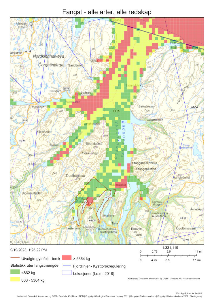
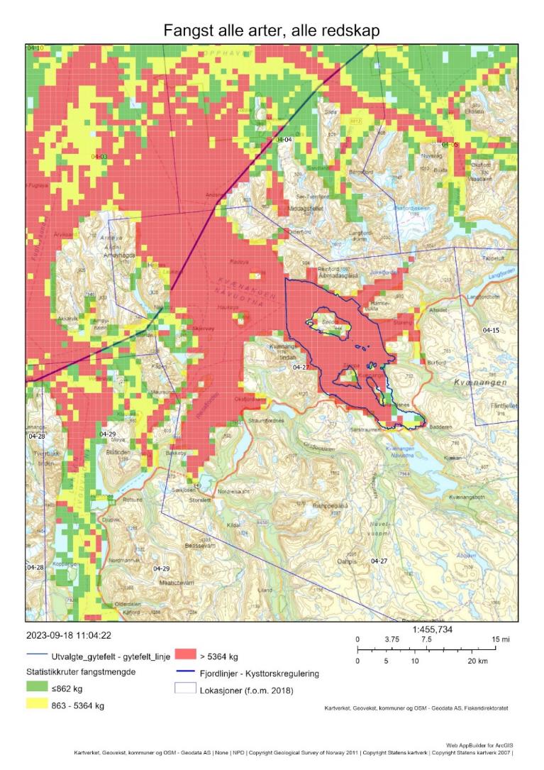
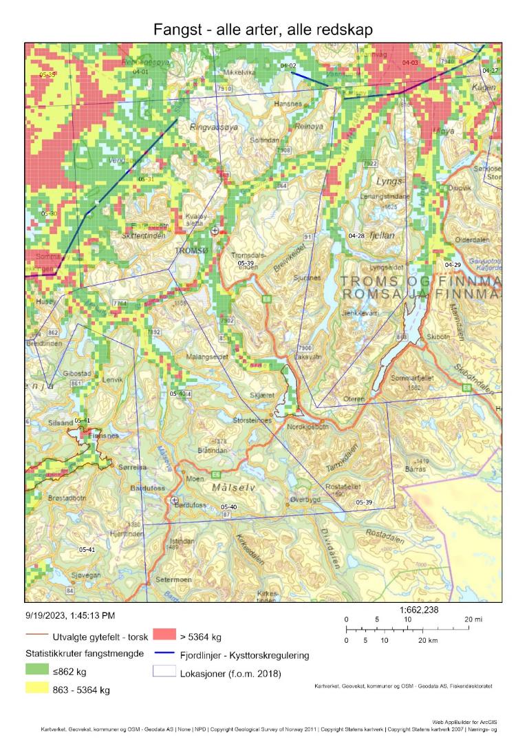
I hvert kapitel presenteres et kart som viser den samlete fiskeriaktiviteten i den aktuelle lokasjonen, oppdelt i tre kategorier etter økende aktivitet (grønn, gul, rød). Aktiviteten kunne ikke filtreres på tidspunkt, art eller redskap og kartet viser derfor den totale aktiviteten i perioden 2018-2021 som kunne kobles til sporingsdata. Grenseverdier for visualisering av fiskeriaktivitet er satt basert på en kvantil-fordeling. Det betyr at det er like mange grønne, gule og røde ruter.
1.4.1.3 - Fangst på gytefelt
For å beskrive aktiviteten på selve gytefeltet ble fangsten i 1x1 km rutene som falt innenfor polygonen som definerer gytefeltet summert. Her kunne data tas ut på art, og vi rapporterer fangster av torsk, sei og hyse innenfor gytefeltet. For å vurdere hvor stor andel av fangsten i lokasjonen som ble tatt på selve gytefeltet ble gytefeltfangsten sammenlignet med sluttseddelfangst av respektive art i lokasjonen fra samme tidsperiode.
1.4.1.4 - Biologisk prøvetaking – andel kysttorsk
Otolittprøver fra fiskeri og tokt ble brukt for å anslå andelen kysttorsk i fangsten på lokasjonsnivå. Prøver fra tokt foreligger primært fra oktober-november (Kysttoktet). Prøvetakingen fra fiskerier er designet for å få nok prøver per hovedområde, redskap og kvartal, og i mange tilfeller er det derfor få prøver i enkelte lokasjoner. I de offisielle fangstestimatene for kysttorsk brukes en estimeringsmodell som låner informasjon fra nærliggende områder for å predikere andelen kysttorsk i områder som mangler informasjon fra otolittprøvetaking. I denne rapporten presenterer vi rådata, og bruker dette sammen med ekspertvurderinger for å si noe om andelen kysttorsk på lokasjonsnivå. Det generelle mønsteret basert på genetiske undersøkelser er en minkende andel skrei fra nord til sør og fra ytre til indre kystområder (Dahle et al., 2018, Johansen et al., 2020, Breistein et al., 2022).
1.4.2 - Turistfiskebedrifter
Registeret for turistfiskebedrifter ble brukt for å hente ut geografisk posisjon for bedriftene, til plotting på kart. Et viktig neste steg er å hente ut informasjon om art og kvantum fanget per måned fra registeret, samt å vurdere datakvaliteten. Mer informasjon om usikkerheten i registeret vil komme i rapporten fra pilotprosjektet for regional ressursforvaltning i Andfjorden (Fiskeridirektoratet).
1.4.3 - Akvakultur
I hvert kapittel illustreres plassering av oppdrettsanlegg i lokasjonen basert på Akvakulturregisteret som er fritt tilgjengelig via Yggdrasil. Vi rapporterer klarert kapasitet og art, samlet for lokasjonen og innenfor selve gytefeltet. I noen tilfeller kan gjeldende kapasitet avvike fra klarert kapasitet (se Akvakulturregisteret).
Effekter av lakseoppdrett i nærheten av gyteområder for torsk har blitt studert på gytefeltene rundt Smøla og i Kvænangen (SALCOD og ICOD-prosjektene). Det foreligger enda ikke entydige resultater, men det ble funnet at 20 % av torsk på gytefeltene på Smøla spiser laksefôr, som gjør at torsken får en fettsyreprofil som avviker fra vill torsk (Meier et al., 2023). Effekten av dette er ukjent, og bør studeres videre. Det er også vist at merder påvirker atferden til torsk på gytefelt ved at torsken blir tiltrukket merdene (Skjæraasen et al., 2022).
Effekter av torskeoppdrett på vill torsk ble vurdert i rapporten «Risikorapport norsk fiskeoppdrett 2022» (Grefsrud et al. 2022a, 2022b). Det er dessverre mange kunnskapshull rundt effektene på vill torsk, blant annet grunnet manglende dokumentasjon av egenskapene til den «nye» oppdrettstorsken. Det er primært to effekter av torskeoppdrett som er viktige for å vurdere risiko: genetisk påvirkning på villtorsk (ved gyting i merd eller rømming) og økologiske interaksjoner mellom oppdrettstorsk og villtorsk. Oppsummert vurderes risikoen for negative effekter av torskeoppdrett på ville kysttorskbestander til å være moderat nord for 67°N og høy i området mellom 62°N og 67°N ved omsøkt produksjonskapasitet. Det vises til risikorapporten for mer informasjon.
Notere at både registeret for turistfiskebedrifter og Akvakulturregisteret oppdateres kontinuerlig. Informasjonen i denne rapporten ble hentet ut fra registrene høsten 2023.
1.4.4 - Annen åpen informasjon fra Yggdrasil
Tabell 1 viser andre temalag fra den åpne versjonen av Yggdrasil som har blitt brukt i arbeidet. Beskrivelsen er hentet fra objektinformasjonen for temalaget.
| Navn på temalag | Plassert under | Beskrivelse | Dataeier |
| Lokasjoner (f.o.m. 2018) | Statistikkområder | Statistikkområder er soner fra ICES og Fiskeridirektoratet sine områder for rapportering av fangst. Vi har to nivåer - en som er hovedområder, og en som er lokasjoner. | Fiskeridirektoratet |
| Fjordlinjen – Kysttorskregulering | Fiskerireguleringer | Forskrift om regulering av fisket etter torsk, hyse og sei nord for 62°N, § 32 og Forskrift om gjennomføring av fiske, fangst og høsting av viltlevende marine ressurser (høstingsforskriften) § 31 2023: https://lovdata.no/dokument/SF/forskrift/2022-12-21-2523 https://lovdata.no/dokument/SF/forskrift/2021-12-23-3910/kapVI#kapVI | Fiskeridirektoratet |
| Facilities and pipelines | Olje og gass | Informasjon om blant annet lete- og utvinningsbrønner, undersøkelser, funn og felt og utvinningstillatelser. | Oljedirektoratet |
| Torsk – nordøstarktisk (skrei) | Marint biologisk mangfold – Utbredelse marine arter (HI) | Viser et utvalg av utbredelseskartene fra Havforskningsinstituttet for marine arter. Kartlagene hentes fra den publiserte oppføringen for hver art, og holdes dermed automatisk oppdatert ved eventuelle endringer. For mer informasjon om artsutbredelse, se Havforskningsinstituttet sine nettsider: https://www.hi.no/hi/temasider/arter | Havforskningsinstituttet |
| Gytefelt torsk MB | Marint biologisk mangfold | Kartlaget viser gytefelt for kysttorsk som er kartlagt av Havforskningsinstituttet gjennom «Nasjonalt program for kartlegging av marine naturtyper” (2007-2019)» og «Kartlegging av gytefelt og oppvekstområder for kommersielt viktige arter i kystsonen» (2020-). Kartleggingen har benyttet data fra både feltinnsamling av egg, Fiskeridirektoratets intervjuundersøkelser og modellering av oseanografi for å vurdere hvilke områder som kan være de viktigste gytefeltene for stasjonære bestander av kysttorsk. Oppdatert mars 2022 | Havforskningsinstituttet/ Fiskeridirektoratet |
| Gyteområder torsk | Kystnære fiskeridata | Datasettet viser områder hvor det blir fanget gytende torsk og gyteperioden. Kartlaget er et uttrekk fra datasettet “Gyteområder alle arter” og viser alle områder hvor torsk inngår som en av de gytende artene i området. Opplysningene er samlet inn av Fiskeridirektoratet, i hovedsak gjennom intervju med fiskere. Datasettet er under kontinuerlig oppdatering. | Fiskeridirektoratet |
| Marine naturtyper | Marint biologisk mangfold | Marine naturtyper etter DN håndbok 19 - Kartlegging av marint biologisk mangfold. Relevans: se f.eks . Dunlop et al. (2022) som viser assosiasjon mellom 0-gruppe torsk og habitater som ålegress og skjellsand. | Miljødirektoratet |
1.4.5 - Toktindeks
For gyteområder i det nordlige bestandsområdet presenteres toktindeks av gytebiomasse fra overlappende stratum. Indeksen som rapporteres er fra undersøkelser med bunntrål om høsten i oktober-november, og starter i 2003. Punktestimater fra enkelte stratum kan ha stor usikkerhet. Dette skyldes oftest stor variasjon i trålfangstene innenfor stratumet, og indikerer at torsken er ujevnt fordelt. Andre faktorer som bidrar til usikkerhet i estimatene er f.eks. et lavt antall trålstasjoner, og overlapp mellom skrei og kysttorsk (som skilles basert på otolittlesing).
I rapporten blir gytebiomasseindeksen sammenlignet med uttaket av torsk på gytefeltet og lokasjonen for å få et grovt anslag på om fisket er bærekraftig eller ikke. For den nordlige bestanden har en høstingsgrad på 30 % av SSB blitt vurdert til å være bærekraftig. En vurdering på stratanivå kompliseres av at fangbarheten, det vil si andelen av torsken i området som blir målt i toktet, trolig varierer i rom og tid. Indeksen antas å være proporsjonal mot gytebiomassen på bestandsnivå. Den totale gytebiomasseindeksen i toktet nord for 67°N har blitt estimert til mellom 11 % og 18 % av gytebiomassen i bestanden (fra bestandsvurderingen) i perioden 2018-2021. Det betyr altså at man ved sammenligningen må regne med at den reelle gytebiomassen er 5-10 ganger større enn gytebiomasseindeksen. I tillegg kan vandrende kysttorsk som oppholder seg utenfor lokasjonen om høsten når toktindeksen blir beregnet komme inn i lokasjonen om vinteren-våren for å gyte. Vurderingen må derfor ses på som overordnet og kvalitativ.
1.4.6 - Fremstilling av data
Koblingen mellom fangstkvantum og sporingsdata var tilgjengelig fra perioden 2018-2021. I øvrige figurer og tabeller ble data frem til 2022 brukt for å få et mest mulig oppdatert bilde av uttak og prøvetaking.
Hvert kapitel inneholder minimum følgende figurer og tabeller:
-
Kart over samlet fiskeriaktivitet på lokasjonsnivå oppløst i 1x1 km ruter (2018-2021).
-
Stabeldiagram med torskelandinger på lokasjonsnivå, oppdelt på redskap, måned og fartøystørrelse (2018-2022).
-
Tabell med landinger av torsk per måned, prøvegrunnlag (antall otolitter) bestemt til skrei respektive kysttorsk, og anslag på kysttorskfangst basert på denne prøvetakingen (2018-2022).
-
Tabell med anslått fangst av torsk, hyse og sei innenfor det utvalgte gyteområdet samt prosent fangst i sluttseddel fra fartøy < 15 m (alle arter) som ikke kunne kobles til sporingsdata (2018-2021).
-
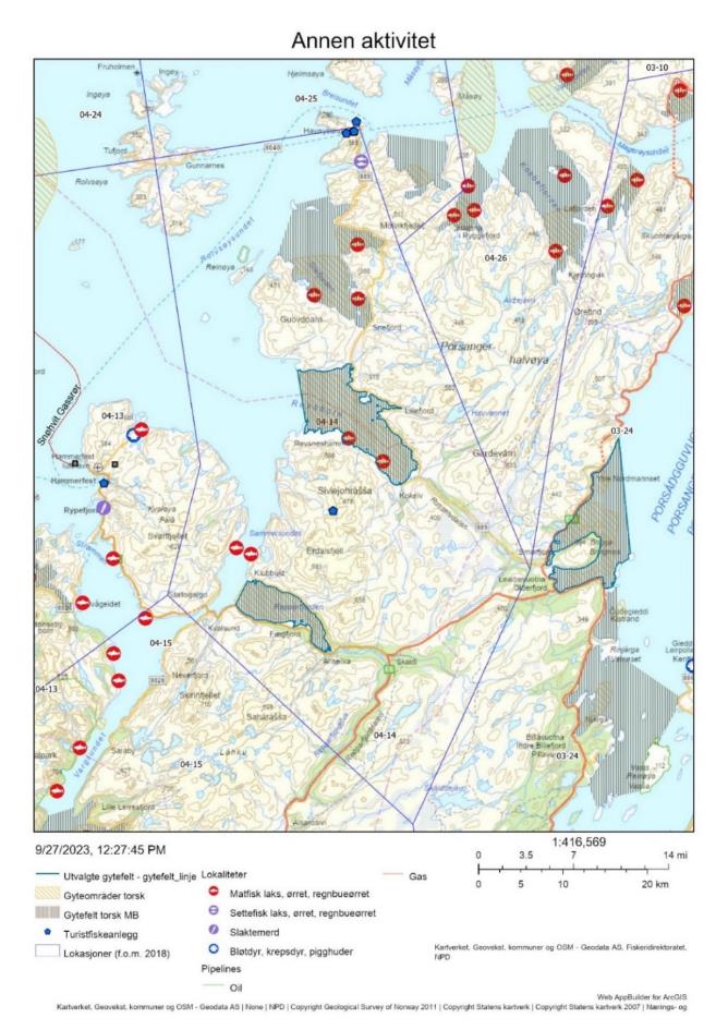
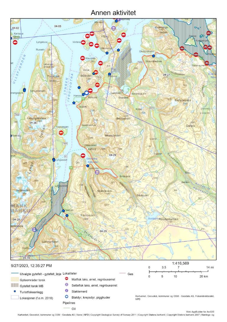
Kart med alle gytefelt i lokasjonen, oppdrettsanlegg, turistfiskebedrifter og olje/gass-ledninger.
Posisjonene for gytefelt som er oppgitt i rapporten er koordinater for omtrent midten av gyteområdet. Det henvises til polygoner i temalaget gytefelt torsk MB i Yggdrasil for mer nøyaktig plassering av og utbredelse til aktuelle gytefelt.
I etterfølgende kapitel presenteres den menneskelige aktiviteten på gytefeltene i rekkefølge fra nord til sør, med supplerende informasjon presentert i fire vedlegg.
2 - Indre Tana og Smalfjorden, Finnmark
Posisjon: 70°30,98′N, 28°1,47′E / 70°28,90′N, 28°7,55′E; lokref: 03-05
2.1 - Beskrivelse av området
Indre Tana er klassifisert som nasjonalt viktig gytefelt (A6) grunnet høy eggtetthet og god retensjon av eggene, og området ble identifisert som gytefelt både i Havforskningsinstituttet sine eggundersøkelser og i Fiskeridirektoratets intervjuundersøkelser med fiskere. Smalfjorden ble klassifisert som regionalt viktig gytefelt (B5) grunnet høy eggtetthet og noe tilbakeholdelse av eggene. Dette området ble ikke identifisert som gytefelt i Fiskeridirektoratets intervjuundersøkelser med fiskere, og det kan derfor ikke utelukkes at noe egg i Smalfjorden kan stamme fra gyting i naboområdet Indre Tana.
I lokasjonen er det identifisert områder med de svært viktige naturtypene «bløtbunnsområde i strandsonen», «skjellsand», og «store tareskogforekomster». Noen av disse områdene ligger innenfor de utvalgte gytefeltene. Tanafjorden har status som Nasjonal laksefjord, der særlig hensyn skal tas til villaksen og dens vandring.
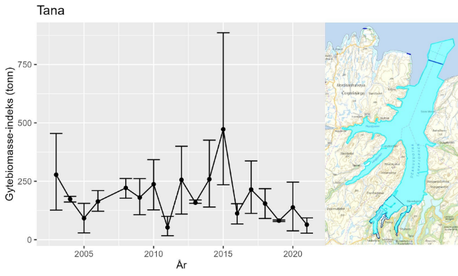
Utviklingen i gytebiomasse-indeks i området «Tana», som inkluderer begge gytefelt, minner om utviklingen for hele kysttorskbestanden nord for 67°N; det var en topp i dette stratumet i 2015 (ca 450 tonn), etterfølgt av en nedgang til et lavere nivå de siste årene (60-100 tonn , Figur 2). Ekstra stor usikkerhet i toppåret 2015 skyldes stor variasjon i trålfangster mellom ulike deler av området, særlig i år med relativt mye torsk.
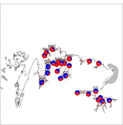
Gytefeltkartleggingen i Tanafjorden (lokasjon 3-5) ble gjennomført i 2016. Da ble det gjort DNA-analyser på egg samlet inn med hensikt å indentifisere andelen kysttorsk/skrei. Modelleringen og observasjoner i forbindelse med eggundersøkelsene viser at gytefeltene Indre Tana og Smalfjorden domineres av kysttorsk. Resultatene viser at det også kommer skrei helt inn på disse feltene for å gyte (Figur 3). Tabell 1 viser at størst andel av skrei i lokasjonen er i april-mai. Dette stemmer med rapporter fra fiskere om et relativt sent gyteinnsig av skrei. To otolittprøver innsamlet av HI den 2. april og 20. april 2022 ved fiskemottak i Torhop viste hhv 65% skrei og 35% skrei.
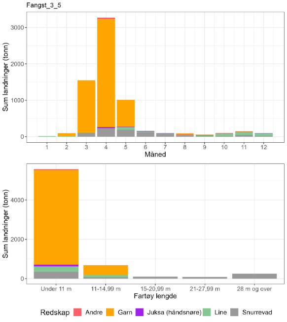
2.2 - Kommersiell fiskeriaktivitet
I lokasjon 3-5, der Indre Tana og Smalfjorden inngår, tas de største mengdene torsk med garn i gytetiden mars-mai (Figur 4). Basert på otolittprøver så er disse fangstene dominert av kysttorsk bortsett ifra april-mai (Tabell 2). Men bare ca. 1% av torskefangstene i område 3-5 er registrert tatt inne i disse gyteområdene (Tabell 3).
Det har blitt observert fiske på gytende torsk i Tana i mai. Slik sen gyting kan tyde på en lokal torskestamme. Sett opp mot totalfangstene i lokasjonen er dette svært små fangster, som allikevel kan være en viktig kilde til dødelighet lokalt.
Det fiskes med snurrevad i alle fartøystørrelse grupper, og fartøy over 15 meter (utenfor fjordlinjen) bruker nesten utelukkende snurrevad. Snurrevadfisket har et litt senere sesongfiske enn garn i lokasjonen, og om høsten kommer line inn som det viktigste redskapet.
Det har helt siden 1996 vært forbudt å bruke snurrevad til fangst av torsk i flere fjordområder i Finnmark i ulike tidsrom (J-201-1996). I Tana (03-05) gjelder dette innenfor en linje fra Digermulen til Trollfjordneset i perioden 1. januar til 31. mai. Dette var på mange måter en forløper for fjordlinjene som ble innført for første gang i 2004, med mål å hindre at store snurrevadfartøyer kunne fiske helt inn på gytefeltene i Indre Tana. Dette blir nå i stor grad ivaretatt av fjordlinjene som bare tillater små lokale snurrevadfartøyer under 11 meter å fiske innenfor.
| Måned | Antall kysttorsk i prøve-materiale | Antall skrei i prøve-materiale | Totalt | Andel kysttorsk | Sum sluttseddelvekt (kg) torsk 2018-2022 | Herav kysttorsk (kg) |
| 1 | 0 | 0 | 0 | Ingen data | 15223 | Ingen data |
| 2 | 94 | 33 | 127 | 0,74 | 93736 | 69379 |
| 3 | 86 | 15 | 101 | 0,85 | 1551688 | 1321239 |
| 4 | 53 | 54 | 107 | 0,50 | 3274100 | 1621750 |
| 5 | 8 | 12 | 20 | 0,40 | 1011726 | 404690 |
| 6 | 0 | 0 | 0 | Ingen data | 159273 | Ingen data |
| 7 | 0 | 0 | 0 | Ingen data | 98320 | Ingen data |
| 8 | 0 | 0 | 0 | Ingen data | 90778 | Ingen data |
| 9 | 36 | 1 | 37 | 0,97 | 53118 | 51682 |
| 10 | 457 | 99 | 556 | 0,82 | 103766 | 85289 |
| 11 | 13 | 4 | 17 | 0,76 | 147742 | 112979 |
| 12 | 0 | 0 | 0 | Ingen data | 93033 | Ingen data |
| Fangst torsk gyte-område | Fangst sei gyte-område | Fangst hyse gyte-område | Fangst torsk lokasjon | Fangst sei lokasjon | Fangst hyse lokasjon | Prosent fangst i gyte-område torsk | Prosent fangst i gyte-område sei | Prosent fangst i gyte-område hyse | Prosent fangst i sluttseddel uten sporing (alle arter) |
| 34 | 0.1 | 0.1 | 5129 | 615 | 877 | 1 | 0 | 0 | 15 |
2.3 - Rekreasjonsfiske
Data på innsats og uttak i rekreasjonsfiske mangler for området.
Det er registrert en turistfiskebedrift i lokasjonen, i Hopsfjorden vest for Skjånes (Figur 5).
2.4 - Annen menneskelig aktivitet i området
Det er ingen akvakulturanlegg i lokasjonen i dag (Figur 5). Etablering av lakseoppdrett er forbudt med hensyn til villaksen.
2.5 - Samlet vurdering av menneskelig aktivitet
2.5.1 - Oppsummering av aktivitet
2.5.1.1 - Gytefeltet
Det foregår et garnfiske (og i mindre grad et snurrevadfiske) etter torsk på gytefeltene i gytetiden, særlig fra fartøy < 11 m. Det anslåtte uttaket på 34 tonn i perioden 2018-2022, d.e. ca 7 tonn/år, er lavt sett opp mot torskefangsten i hele lokasjonen. Det bør allikevel tas høyde for at det reelle uttaket er større når et ikke-kvantifisert turist- og fritidsfisket tas med i beregningene, og for at toktmålingene indikerer en negativ utvikling. Det er ingen oppdrettsanlegg i sjø innenfor gytefeltet.
2.5.1.2 - Lokasjonen - innenfor og utenfor fjordlinjen
En del av lokasjonen ligger utenfor fjordlinjen. Fangsten på 5000-6000 tonn torsk samlet for perioden 2018-2022, d.e., herav ca 800 tonn kysttorsk per år, er svært høyt sett opp mot en gytebiomasseindeks på ca 100 tonn for hele lokasjonen (tilsvarende anslagsvis 10-20 % av reell gytebiomasse). Det bør tas høyde for at gytebiomassen er beregnet om høsten, og at det kan komme inn vandrende kysttorsk i gytetiden som det fiskes på. Hyse- og seifangstene i lokasjonen utgjør til sammen ca 30% av torskefangstene. Den ene turistfiskebedriften i lokasjonen har liten påvirkning på gytetorsken i Indre Tana og Smalfjorden. Det er ingen akvakulturanlegg i lokasjonen i dag.
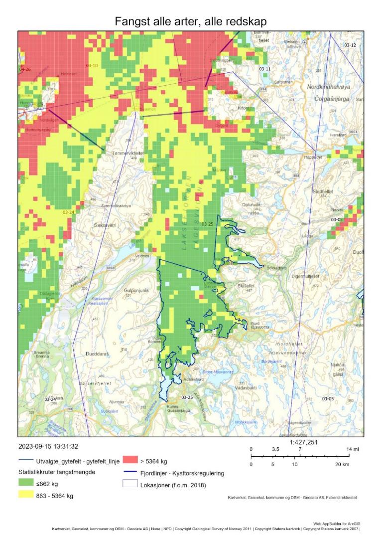
Det er stor fiskeaktivitet i lokasjon 03-05 utenfor fjordlinjen. Her får båter > 15 meter også anledning til å fiske torsk, og disse båtene fisker da hovedsakelig med snurrevad.
2.5.2 - Konklusjon
Den menneskelige aktiviteten i form av fiske vurderes å være høy i lokasjonen, men lav på selve gytefeltene. Det fiskes et relativt stort kvantum kysttorsk i lokasjonen i gytetiden i forbindelse med skreiinnsiget, primært utenfor de utvalgte gytefeltene. Det tilrås at dette uttaket reduseres og at uttaket på selve gytefeltene holdes på et lavt nivå.
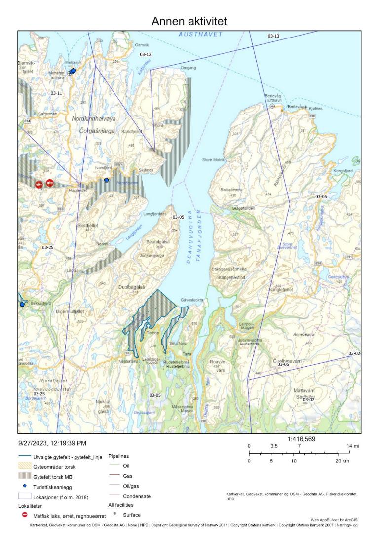
3 - Torskefjord/Bekkarfjord og Indre Laksefjord, Finnmark
Posisjon: 70°39'36"N, 27°02'18.0"E / 70°32'42.0"N, 26°45'42.0"E; lokref: 3-25
3.1 - Beskrivelse av området
Torskefjord/Bekkarfjord og Indre Laksefjord er klassifisert som regional viktige gytefelt (B5) grunnet middels eggtetthet og god retensjon av eggene. Begge fjordene har blitt identifisert som gytefelt både i Havforskningsinstituttet sine eggundersøkelser og i Fiskeridirektoratets intervjuundersøkelser med fiskere. I samme lokasjon, i ytre deler av Laksefjord, ligger et mindre viktig gyteområde for skrei (Eidsfjorden/ Mårøyfjorden). Det er også kjent at skrei gyter i Austhavet utenfor munningene til Porsanger- og Laksefjorden.
I Laksefjorden er det kartlagt flere bløtbunnsområder i strandsonen, en naturtype som en klassifisert som svært viktig og som kan utgjøre oppvekstområde for torsk og annen bunnfisk. Noen av områdene overlapper med gytefeltet Indre Laksefjord.
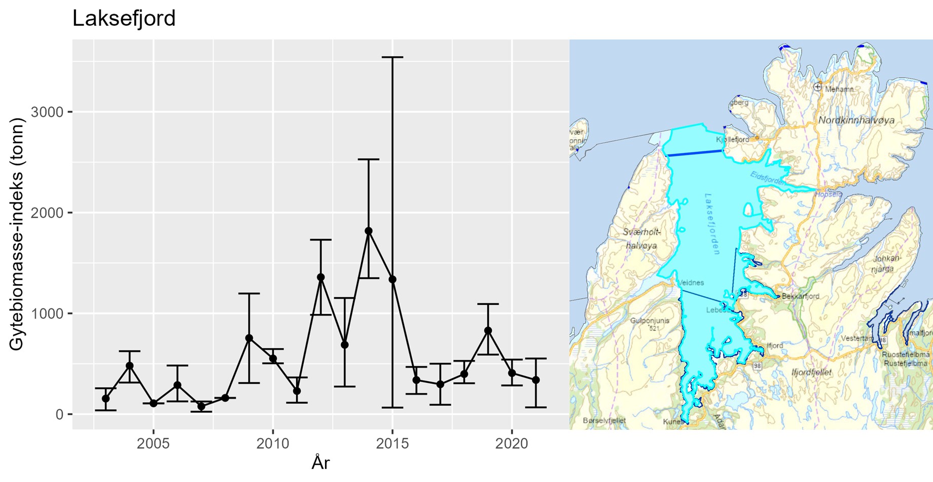
Utviklingen i gytebiomasse-indeks i Laksefjorden er nokså lik utviklingen for hele bestanden nord for 67°N; det var en topp i 2014-2015, etterfølgt av en nedgang til et lavere nivå de siste årene (300-800 tonn, Figur 7). Estimatet fra 2015 har høy usikkerhet, noe som tilsier at det var stor variasjon i mengden kysttorsk innenfor stratumet.
Det ble gjort DNA-analyser på egg samlet inn under gytefeltskartleggingen i 2016 med hensikt på å indentifisere andelen kysttorsk/skrei. Kysttorsk dominerte i Indre Laksefjord, men det var noe skreiinnslag i prøven (Figur 8). Et lignende mønster observeres i Kysttoktet på høsten. Det foreligger konserverte eggprøver fra flere år som kan analyseres på samme måte.
Det er ikke kjent om kysttorsken som gyter i området er stasjonær eller migrerende.
3.2 - Kommersiell fiskeriaktivitet
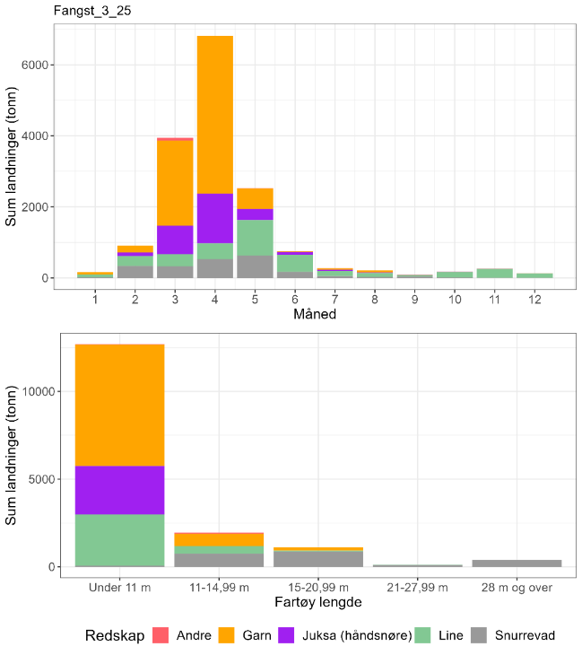
I lokasjon 3-25, der de aktuelle gytefeltene inngår, tas de største mengdene torsk med garn av fartøy < 11 m rett før og i gytetiden (mars-mai, Figur 9). Det er også relativt store fangster med jukse og line i denne perioden, og linefisket fortsetter i mindre omfang utover høsten. I tillegg fanges det torsk med snurrevad fra større fartøy, hovedsakelig i gytetiden. En stor del av fangstene tas lenger ute i Laksefjorden og kan antas å være mest skrei (Figur 6 og Tabell 4). De store skreifangstene i gytetiden innebærer allikevel at det fanges relativt store mengder kysttorsk i lokasjonen (Tabell 4). En svært liten andel av torskefangstene tas inne på selve gytefeltet (Tabell 5).
| Måned | Antall kysttorsk i prøve-materiale | Antall skrei i prøve-materiale | Totalt | Andel kysttorsk | Sum sluttseddelvekt (kg) torsk 2018-2022 | Herav kysttorsk (kg) |
| 1 | 0 | 0 | 0 | Ingen data | 158651 | Ingen data |
| 2 | 3 | 16 | 19 | 0,16 | 908301 | 143416 |
| 3 | 0 | 0 | 0 | Ingen data | 3944370 | Ingen data |
| 4 | 2 | 13 | 15 | 0,13 | 6819569 | 909276 |
| 5 | 10 | 70 | 80 | 0,13 | 2531253 | 316407 |
| 6 | 0 | 0 | 0 | Ingen data | 749070 | Ingen data |
| 7 | 0 | 0 | 0 | Ingen data | 272997 | Ingen data |
| 8 | 0 | 0 | 0 | Ingen data | 210331 | Ingen data |
| 9 | 0 | 0 | 0 | Ingen data | 92928 | Ingen data |
| 10 | 333 | 37 | 370 | 0,90 | 174980 | 157482 |
| 11 | 16 | 4 | 20 | 0,80 | 260371 | 208297 |
| 12 | 0 | 0 | 0 | Ingen data | 135174 | Ingen data |
| Fangst torsk gyte-område | Fangst sei gyte-område | Fangst hyse gyte-område | Fangst torsk lokasjon | Fangst sei lokasjon | Fangst hyse lokasjon | Prosent fangst i gyte-område torsk | Prosent fangst i gyte-område sei | Prosent fangst i gyte-område hyse | Prosent fangst i sluttseddel uten sporing (alle arter) |
| 10 | 0 | 0.9 | 12742 | 646 | 1627 | < 0.1 | 0 | < 0.1 | 10 |
3.3 - Rekreasjonsfiske
Data på innsats og uttak i rekreasjonsfiske mangler for området.
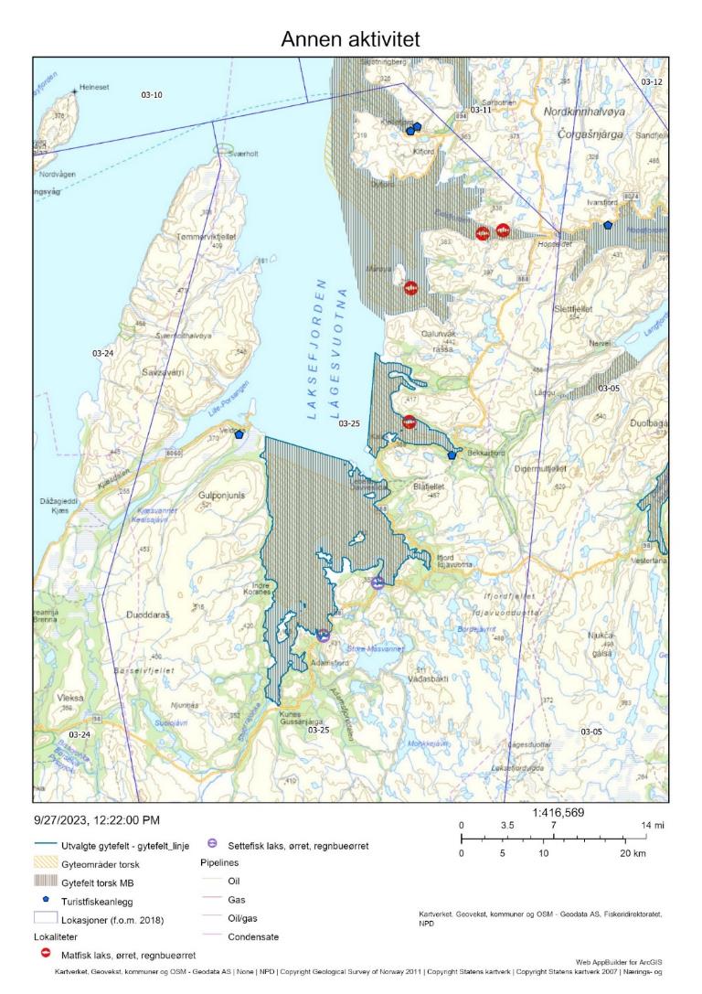
Det er registret fire turistfiskebedrifter i lokasjonen, hvorav en ligger i tilknytting til gytefeltet Bekkarfjorden (Figur 10).
3.4 - Annen menneskelig aktivitet i området
Det er ett oppdrettsanlegg for laks/regnbueørret/ørret i Bekkarfjorden og tre andre lengre nord i Laksefjord (i Eidsfjorden og Mårøyfjorden, Figur 10). Disse har en samlet kapasitet på 17 520 tonn, hvorav 4 725 tonn er plassert innenfor gytefeltet i Bekkarfjorden. Det er ingen oppdrettsanlegg i sjø på gytefeltet Indre Laksefjord.
3.5 - Samlet vurdering av menneskelig aktivitet
3.5.1 - Oppsummering av aktivitet
3.5.1.1 - Gytefeltet
Det foregår et lite torskefiske på gytefeltene i gytetiden. Gytefeltene er rangert på plass 17/22 i forhold til andelen fangst av total torskefangst i lokasjonen som tas innenfor det utvalgte gytefeltet, og plass 13/22 i forhold til kvantum fanget på gytefeltet (Vedlegg 1 og 2). Det anslåtte uttaket på 12 tonn i perioden 2018-2021 er lavt sett opp mot biomasse-indeksen av kysttorsk i området. Det bør allikevel tas høyde for at det reelle uttaket er større siden turist- og fritidsfiske ikke er med i beregningene. Det er et oppdrettsanlegg i sjø og en turistfiskebedrift i Bekkarfjorden, og en turistfiskebedrift registrert nære Indre Laksefjord.
3.5.1.2 - Lokasjonen - innenfor og utenfor fjordlinjen
Mesteparten av lokasjonen ligger innenfor fjordlinjen. Skrei dominerer torskefangstene i gytetiden (basert på prøver tatt i februar, april og mai, Tabell 4), men siden fangstene er så store så fanges det også relativt store mengder kysttorsk. Det anslåtte kvantumet av kysttorsk fanget i lokasjonen er 3 000 tonn samlet for perioden 2018-2022 og er rangert på plass 30 av 563 lokasjoner på kysten det det fiskes torsk (Vedlegg 3, med antakelse om at 80 % av fangsten i Q3 er kysttorsk). Dette uttaket kan være høyt sett opp mot en årlig gytebiomasseindeks på 300-800 tonn i samme periode, avhengig av forholdet mellom indeksen og den totale gytebiomassen i området og hvor mye vandrende kysttorsk som kommer inn for å gyte (se avsnittet om toktindeks i introduksjonen for en diskusjon rundt dette). Utover kommersielle fangster bør det regnes med uttak i turist- og fritidsfisket, med fire turistfiskebedrifter registrert i området. Toktmålingene av gytebiomasse i Laksefjorden indikerer et betydelig lavere nivå de siste årene sammenlignet med årene rundt 2015. Det fanges også en del hyse og sei i lokasjonen, men disse fangstene er små sammenlignet med torskefangsten. Det er noe oppdrettsaktivitet av laksefisk i lokasjonen, men eventuelle negative effekter av dette er trolig lave i forhold til effekten av fiske.
3.5.2 - Konklusjon
Det foregår et omfattende fiske etter gytende torsk i Laksefjorden. Fangsten domineres av skrei, men betydelige mengder kysttorsk tas som «bifangst». Overordnet vurderes den menneskelige aktiviteten til å være forholdsvis lav i gyteområdet, men stor i lokasjonen. Den negative utviklingen i toktindeks for kysttorsk i lokasjonen tilsier at torskefisket bør begrenses for å beskytte kysttorsken i området. Redusert torskefangst i lokasjonen kan i tillegg til å beskytte den lokale torsken gi utslag på bestandsnivå for den nordlige kysttorskbestanden, der fangsten i henhold til kvoterådet bør reduseres med omtrent 40 %.
4 - Smørfjorden, Porsanger, Finnmark
Posisjon: 70˚33’12’’N, 25˚14’48’’E; lokref: 03-24
4.1 - Beskrivelse av området
Smørfjorden er klassifisert som nasjonalt viktig gytefelt (A6) grunnet høy eggtetthet og god retensjon av eggene, og området ble identifisert som gytefelt både i Havforskningsinstituttet sine eggundersøkelser i 2016 og i Fiskeridirektoratets intervjuundersøkelser med fiskere. I en mulighetsstudie «Porsangerfjorden 2.0» (Strand 2019) ble det foreslått å etablere to soner i Porsangerfjorden med strengt regulert fiske, og en tredje sone der fiskeriene kan fortsette som før. Gytefeltet i Smørfjorden ville i dette forslaget falle inn under/samsvare med det strengeste vernet som har til hensikt å øke ungfiskproduksjonen. Forslaget møtte stor motstand hos lokale fiskere siden de fisker mesteparten av torskekvoten sin på gytefeltet i Smørfjorden (Hans Kristian Strand, pers. komm.).
I Porsangerfjorden er det identifisert mange bløtbunnsområder i strandsonen. Denne svært viktige naturtypen overlapper også med gytefeltet i Smørfjorden. Porsangen er en Nasjonal laksefjord.
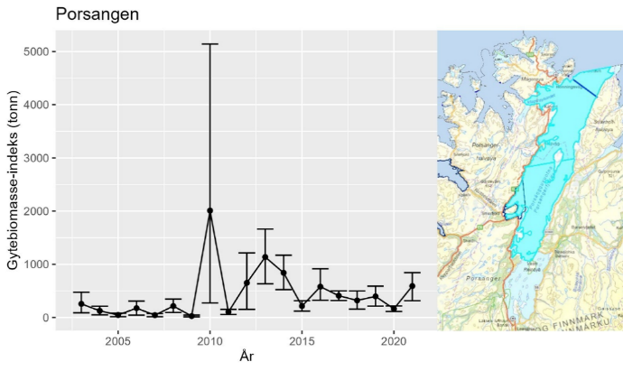
Utviklingen i gytebiomasse-indeks for kysttorsk i området «Porsangen» viser en nåværende gytebiomasseindeks på kring 500 tonn (Figur 12), noe lavere enn i perioden 2012-2014, men likevel høyere enn før 2010.
Gytefeltkartleggingen i Porsangerfjorden (lokasjon 3-24) ble gjennomført i 2016. Da ble det gjort DNA-analyser på egg samlet inn med hensikt å indentifisere andelen kysttorsk/skrei. Modelleringen og observasjoner i forbindelse med egg-undersøkelsene viser at gytefeltene innenfor Tamsøya inkl. Smørfjorden domineres av kysttorsk, men at det også kommer skrei helt inn på disse feltene for å gyte (Figur 13). Genetikk- og otolittprøver tatt i Smørfjorden i februar 2019 viste omtrent 80 % kysttorsk. Tabell 6 viser at skreiandelen i lokasjonen varierer, og at det derfor vil være nødvendig med en mer omfattende prøvetaking (genetikk og/eller otolitter) for å bli mer presis angående dette forholdet.
4.2 - Kommersiell fiskeriaktivitet
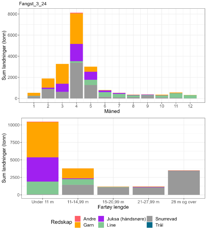
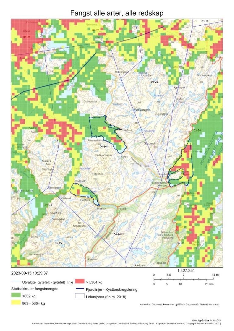
En del av fiskeaktiviteten i indre Porsanger i Figur 11 er relatert til kongekrabbefiske. Det har helt siden 1996 vært forbudt å bruke snurrevad til fangst av torsk i flere fjordområder i Finnmark i ulike tidsrom (J-201-1996). I Porsanger (03-24) gjelder dette innenfor en linje fra Grunnvågflua ved Veidneset til Leirpollen på østsiden av fjorden (like nord for/utenfor Holmfjord) i perioden 1. januar til 31. mai. Dette var på mange måter en forløper for fjordlinjene som ikke kom før i 2004, med mål å hindre at store snurrevadfartøyer kunne fiske helt inn på fiskefeltene i indre Porsanger. Dette hindrer dog ikke snurrevad fartøy under 11 meter fra å fiske inne på gytefeltet Smørfjorden, men Figur 14 viser at det er ingen fartøy under 11 meter som pt fisker med snurrevad i lokasjon 03-24. Snurrevadfartøy over 11 meter må i dag holde seg utenfor fjordlinjen. Mye av fangstene i Figur 14 er tatt på Kjelviklandet og levert til Honningsvåg og Nordvågen AS, mens en kan anta at fangstene i Smørfjord i hovedsak leveres på Smørfjordbruket. I følge Råfiskarlaget har landingene av torsk på Smørfjordbruket ligget rundt 200 tonn de siste 10 årene.
| Måned | Antall kysttorsk i prøve-materiale | Antall skrei i prøve-materiale | Totalt | Andel kysttorsk | Sum sluttseddelvekt (kg) torsk 2018-2022 | Herav kysttorsk (kg) |
| 1 | 0 | 0 | 0 | Ingen data | 532035 | Ingen data |
| 2 | 54 | 45 | 99 | 0,55 | 1897047 | 1034753 |
| 3 | 5 | 48 | 53 | 0,09 | 3273415 | 308813 |
| 4 | 153 | 86 | 239 | 0,64 | 8126871 | 5202557 |
| 5 | 7 | 33 | 40 | 0,18 | 3011579 | 527026 |
| 6 | 0 | 0 | 0 | Ingen data | 792671 | Ingen data |
| 7 | 0 | 0 | 0 | Ingen data | 539232 | Ingen data |
| 8 | 0 | 0 | 0 | Ingen data | 353216 | Ingen data |
| 9 | 20 | 0 | 20 | 1 | 383241 | 383241 |
| 10 | 963 | 118 | 1081 | 0,89 | 352273 | 313820 |
| 11 | 15 | 15 | 30 | 0,50 | 565483 | 282741 |
| 12 | 0 | 0 | 0 | Ingen data | 330772 | Ingen data |
| Fangst torsk gyte-område | Fangst sei gyte-område | Fangst hyse gyte-område | Fangst torsk lokasjon | Fangst sei lokasjon | Fangst hyse lokasjon | Prosent fangst i gyte-område torsk | Prosent fangst i gyte-område sei | Prosent fangst i gyte-område hyse | Prosent fangst i sluttseddel uten sporing (alle arter) |
| 292 | 0 | 0.4 | 17011 | 5977 | 2105 | 2 | 0 | < 0.01 | 9 |
4.3 - Rekreasjonsfiske
Data på innsats og uttak i rekreasjonsfiske mangler for området.
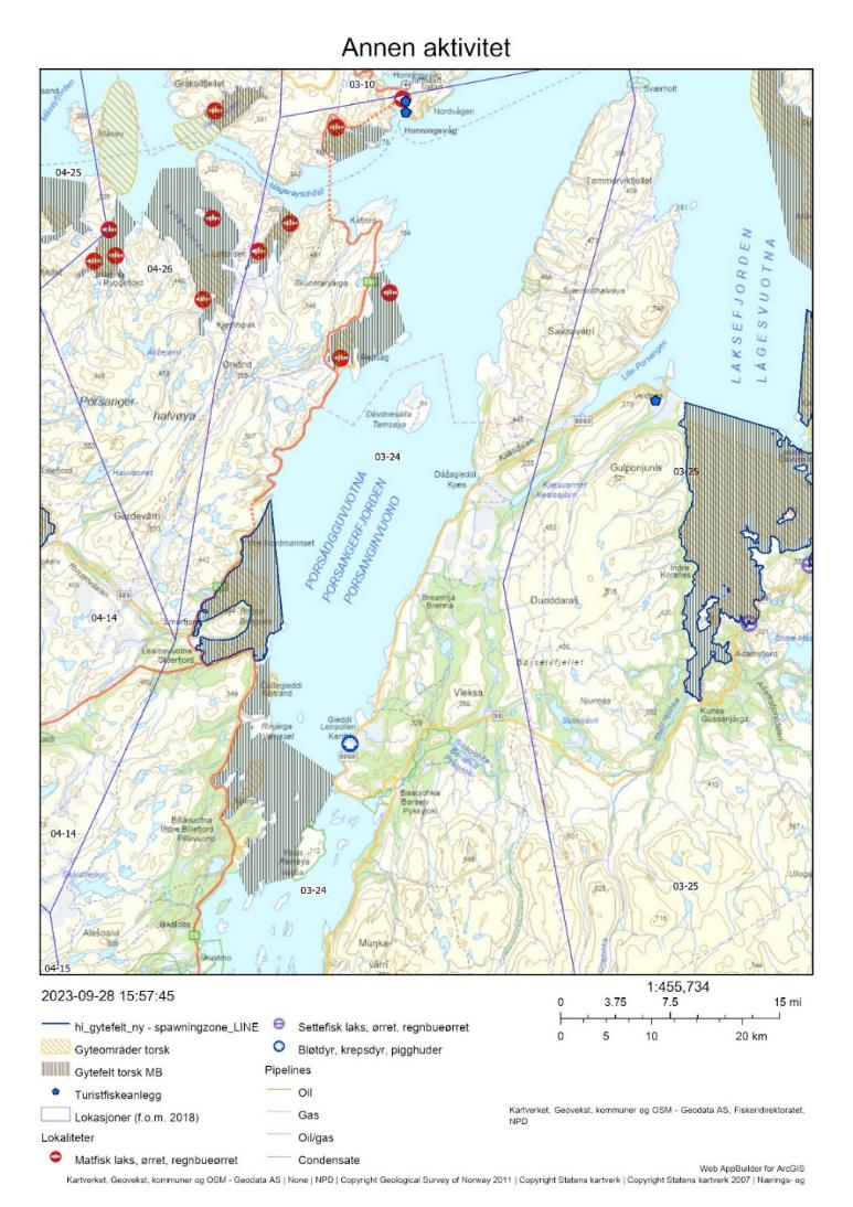
Det er registrert 2 turistfiskebedrifter helt nord i lokasjonen, i Honningsvåg (Figur 15).
4.4 - Annen menneskelig aktivitet i området
Det er ingen akvakultur i sjø i selve gyteområdet (Figur 15), men det er flere anlegg lengre nord i lokasjonen (nordvest for Tamsøya), som har en samlet kapasitet på 25 765 tonn laks/regnbueørret/ørret.
4.5 - Samlet vurdering av menneskelig aktivitet
4.5.1 - Oppsummering av aktivitet
4.5.1.1 - Gytefeltet
Fiske med garn er ikke like dominerende i Porsangerfjorden som i mange andre fjorder. For fartøy < 11 meter fiskes det like mye torsk til sammen med line og juksa som med garn, og for fartøy mellom 11-14,99 m fiskes det meste av torsken med snurrevad og garn, omtrent like mye med hver av disse redskapene. På selve gytefeltet dominerer imidlertid garnfiske i gytetiden, og da fra fartøy < 15 m. Gytefeltet er rangert på plass 11/22 i forhold til andelen fangst av total torskefangst i lokasjonen som tas innenfor det utvalgte gytefeltet, og plass 2/22 i forhold til kvantum fanget på gytefeltet (Vedlegg 1 og 2). Det anslåtte uttaket på 292 tonn torsk i perioden 2018-2022, dvs. ca 60 tonn per år, der det kan antas as mesteparten er kysttorsk, er relativt lavt sett opp mot biomasse-indeksen av kysttorsk i området på 300-600 tonn (som anslagsvis utgjør 10-20 % av den reelle gytebiomassen i området). Det bør allikevel tas høyde for usikkerhet knyttet til at turist- og fritidsfisket ikke er tatt med i beregningene, og at biomassen er målt om høsten. Det er ingen oppdrettsanlegg i sjø innenfor gytefeltet.
4.5.1.2 - Lokasjonen - innenfor og utenfor fjordlinjen
Hele lokasjonen ligger innenfor fjordlinjen. Det anslåtte kvantumet av kysttorsk fanget i lokasjonen er rangert på plass 11 av 563 lokasjoner på kysten det det fiskes torsk (Vedlegg 2). Fangsten på nesten 20 000 tonn torsk samlet for perioden 2018-2022, hvorav over 8 000 tonn (1 600 tonn per år) er anslått til å være kysttorsk, vurderes å være høy sett opp mot en gytebiomasseindeks av kysttorsk på 300-600 tonn målt om høsten. Det antas derfor at en god del av kysttorsken som kommer inn i fjorden i gytetiden er vandrende kysttorsk. Hyse- og seifangstene i lokasjonen utgjør omtrent halvparten av torskefangstene. Oppdrettsanlegg for blant annet laksefisk overlapper med gytefeltene i de nordlige delene av lokasjonen.
4.5.2 - Konklusjon
Uttaket av kysttorsk i lokasjonen er høyt i forhold til gytebiomassen målt om høsten, og mye av kysttorsken som det fiskes på i gytesesongen må mest sannsynlig derfor være vandrende kysttorsk som kommer inn i fjorden for å gyte. Det tilrås en reduksjon i uttaket på lokasjonsnivå for å beskytte innsiget av gytetorsk.
5 - Revsbotn og Repparfjorden, Finnmark
Posisjon: 70°41’48’’ N, 24°28'48.0" E / 70°30'48"N, 24°05'24"E; lokref: 4-14
5.1 - Beskrivelse av området
Både Revsbotn og Repparfjorden er klassifisert som nasjonalt viktige gytefelt grunnet høy eggtetthet og god retensjon av eggene. Begge fjordene har blitt identifisert som gytefelt både i Havforskningsinstituttet sine eggundersøkelser og i Fiskeridirektoratets intervjuundersøkelser med fiskere. Lengre nord i lokasjonen ligger et tredje gyteområde, «Snefjorden» som er klassifisert som lokalt viktig (se Figur 22). Utenfor fjordene, ved Sørøya, er det gyteområde for skrei.
Innerst i begge fjorder er det bløtbunnsområder, som er klassifisert som «svært viktige» (Revsbotn) respektive «viktige» (Repparfjorden). I Revsbotn finnes i tillegg viktige områder med skjellsand. Havforskningsinstituttet har observert områder med tareforekomster i innerste del av Repparfjorden, der det var gode forekomster av torskeyngel ved undersøkelser med ruser.
Utviklingen i gytebiomasse-indeks i området «Hjelmsøy Indre», som inkluderer begge gytefelter, minner om utviklingen for hele bestanden nord for 67°N; det var en topp i dette stratumet et år før toppen kom i bestanden (2014-2015), etterfølgt av en nedgang til et lavere nivå de siste årene (300-400 tonn , Figur 17). Estimatene har relativt stor usikkerhet. Dette skyldes stor variasjon i trålfangster mellom ulike deler av området, særlig i år med relativt mye torsk.
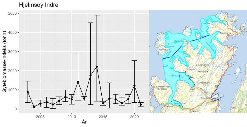
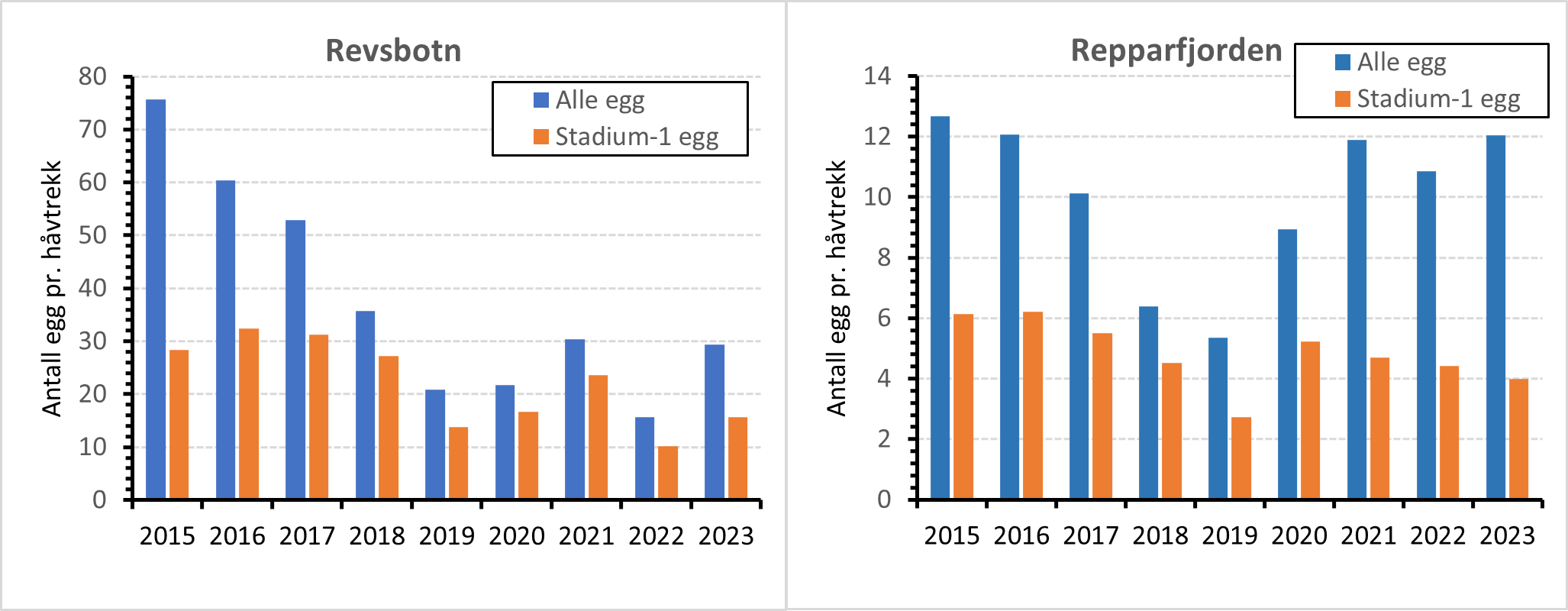
Havforskningsinstituttet har siden 2015 utført grundige årlige eggundersøkelser i Revsbotn og Repparfjorden, med tre runder med prøvetaking gjennom gytesesongen (Figur 18). Undersøkelsene startet som et overvåkingsprogram i forbindelse med løyve for deponering av gruveavfall i Repparfjorden. Hensikten var å etablere en overvåkingsdesign av typen BACI (Before-After-Control-Impact), med overvåking av Repparfjorden før og etter deponeringen startet, samt overvåking av Revsbotn som kontrollområde. Deponiet har ennå ikke blitt tatt i bruk, men overvåkingen har fortsatt og vi har i dag gode tidsserier med eggdata fra begge områder (Figur 19). Eggdataene har blitt sammenlignet med toktindeks av kysttorsk-gytebiomasse fra høsten før, med god korrelasjon. De siste årene har det vært en negativ utvikling i gytebiomasseindeksen i området, og dette er reflektert i en nedgang i målte eggmengder i Revsbotn, mens utviklingen i Repparfjorden er mer variabel (Figur 19).
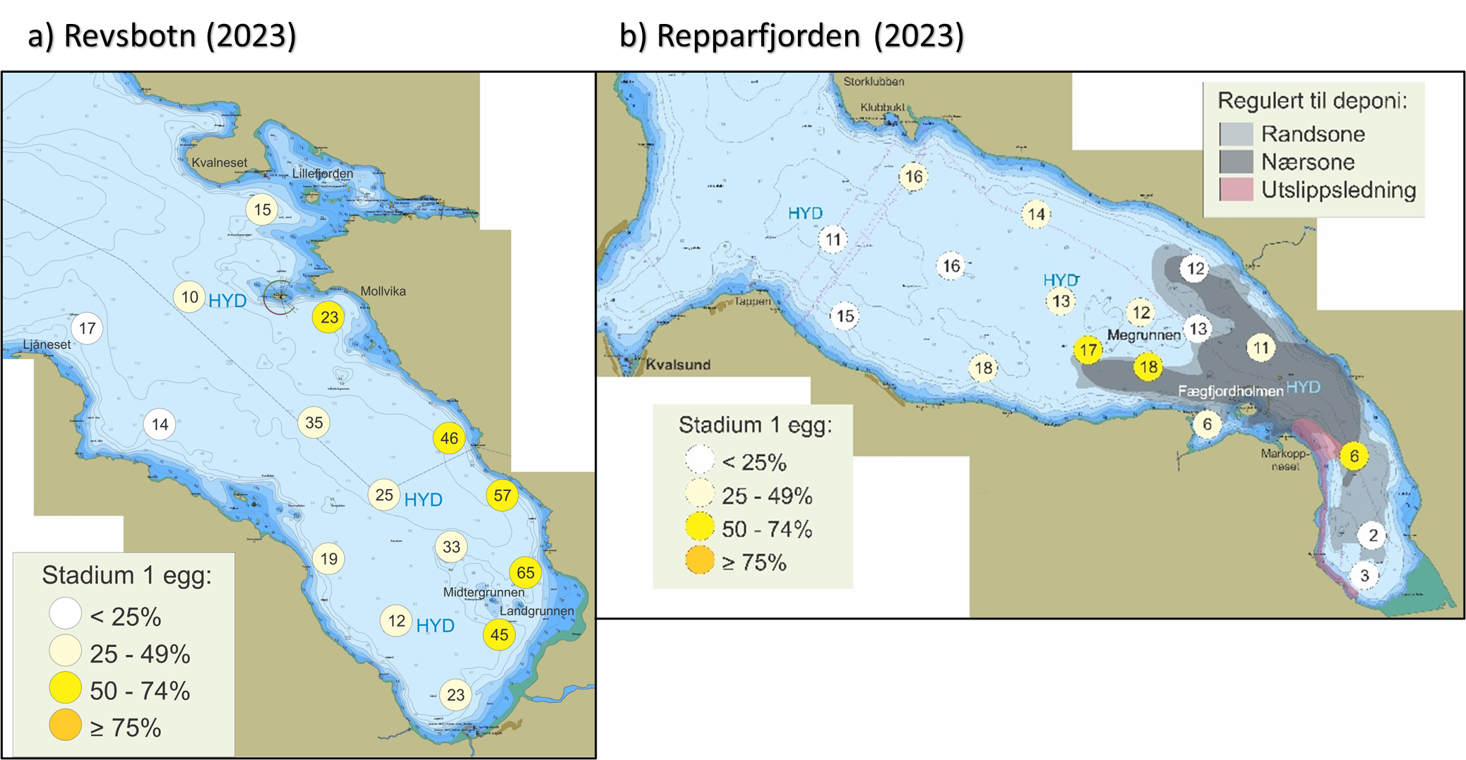
Det ble gjort DNA-analyser på egg samlet inn under gytefeltskartleggingen i 2016 med hensikt på å indentifisere andelen kysttorsk/skrei. I et område som også omfatter Porsangerfjorden og Alta har det i tillegg blitt gjort modellering av spredning av skreiegg som er gytt i Breivikfjorden («Lille Lofoten») på sørvestsiden av Sørøya. Modelleringen og observasjoner i forbindelse med eggundersøkelsene viser at det er noe inndrift av skreiegg i Revsbotn som gir en blanding av kysttorsk- og skreiegg i denne fjorden, mens kysttorskegg dominerer i Repparfjorden (Figur 20). Det foreligger konserverte eggprøver fra flere år som kan analyseres på samme måte.
I 2023 ble det observert relativt store mengder gytende skrei ved Sørøya, og relativt høye andeler eldre torskeegg i ytre deler av både Revsbotn og Repparfjord (Figur 18), noe som kan tyde på inndrift av skreiegg i begge fjorder. På høsten måles det høye andeler kysttorsk i området.
I rapporten fra eggundersøkelsene i 2015 diskuteres hvilken type torsk som gyter i fjordene (van der Meeren, 2015):
«Ifølge lokale fiskere fantes det en lokal fjordtorsk som hadde gyting i mai i Repparfjorden, men denne ble kraftig redusert for vel 30 år siden. Videre er torsk som ble merket under gytesesongen i Revsbotn i perioden 1980 til 1983, funnet igjen i mange fjorder i Troms og Finnmark, fra Kvænangen til Tanafjorden, samt i havet sør for Nordkappbanken (Jakobsen, upublisert). […] Dette viser at en betydelig del av torsken i Revsbotn har tidligere vært vandrende torsk. Tilsvarende data finnes ikke for Repparfjorden, og det finnes heller ikke nyere undersøkelser om dette i noen av de to fjordene. […] Ut fra observasjoner på ekkoloddet under toktene i Repparfjorden ble det imidlertid sett mye færre fisk nær bunnen på Tokt-3 i slutten av mai sammenlignet med Tokt-1 og Tokt-2 i april. Dette kan tyde på at gytingen i april var dominert av vandrende torsk som forlater fjorden i mai når gytingen er over. Også den store variasjonen i eggmengder mellom to påfølgende år kan tyde på at det er vandrende torsk som gyter i de to fjordene, fordi innsiget av slik torsk og derved mengden torsk som gyter, kan variere mye. Denne torsken kan være vandrende kysttorsk eller skrei. Hvis hovedkomponenten av torsken som gyter i Repparfjorden og Revsbotn er vandrende kysttorsk, kan disse to fjordene være viktige som gyteområder i et regionalt perspektiv.»
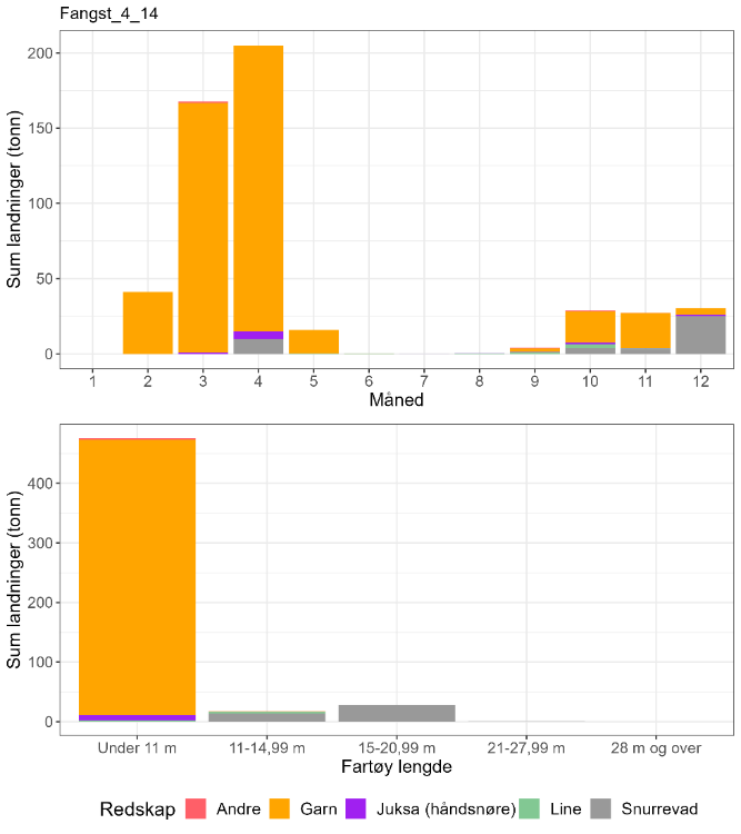
5.2 - Kommersiell fiskeriaktivitet
I lokasjon 4-14, der Revsbotn og Repparfjorden inngår, tas de største mengdene torsk med garn rett før og i gytetiden (mars-april, Figur 21). Basert på et begrenset antall prøver fra februar kan disse fangstene være dominert av skrei (Tabell 8), men siden kysttorsken i Revsbotn troligvis migrerer inn for å gyte kan dette fisket allikevel ha en negativ innvirkning på gytebiomassen i området. I tillegg er det estimert at omtrent 25 % av de totale torskefangstene i lokasjonen tas inne på gyteområdene (samlet estimat for Revsbotn og Repparfjord, Tabell 9), noe som tilsier at prøvetakingen ikke nødvendigvis viser den faktiske andelen kysttorsk som fiskes i gytetiden.
Det har blitt observert fiske på gytende torsk i Repparfjorden i mai. Slik sen gyting kan tyde på en lokal torskestamme. Sett opp mot totalfangstene i lokasjonen er dette svært små fangster, som allikevel kan være en viktig kilde til dødelighet lokalt. Videre er det registrert noe torskefangst med snurrevad i april og oktober-november, fra større fartøy (Figur 21). Fangsten på høsten domineres av kysttorsk (Tabell 8).
På sommeren fiskes det krabbe i Repparfjorden, men noen teiner blir meldt inn allerede i februar-april. Det er ikke undersøkt her om dette fisket har bifangst av torsk. Eksperimentelle forsøk viser at fangsteffektiviteten for torsk i teinefiske er svært variabel (Utne Palm, 2022).
| Måned | Antall kysttorsk i prøve-materiale | Antall skrei i prøve-materiale | Totalt | Andel kysttorsk | Sum sluttseddelvekt (kg) torsk 2018-2022 | Herav kysttorsk (kg) |
| 1 | 0 | 0 | 0 | Ingen data | 0 | Ingen data |
| 2 | 2 | 18 | 20 | 0,10 | 41101 | 4110 |
| 3 | 0 | 0 | 0 | Ingen data | 167793 | Ingen data |
| 4 | 0 | 0 | 0 | Ingen data | 204874 | Ingen data |
| 5 | 0 | 0 | 0 | Ingen data | 15860 | Ingen data |
| 6 | 0 | 0 | 0 | Ingen data | 303 | Ingen data |
| 7 | 0 | 0 | 0 | Ingen data | 45 | Ingen data |
| 8 | 0 | 0 | 0 | Ingen data | 504 | Ingen data |
| 9 | 0 | 0 | 0 | Ingen data | 4106 | Ingen data |
| 10 | 341 | 22 | 363 | 0,94 | 28884 | 27134 |
| 11 | 0 | 0 | 0 | Ingen data | 27341 | Ingen data |
| 12 | 0 | 0 | 0 | Ingen data | 30388 | Ingen data |
| Fangst torsk gyte-område | Fangst sei gyte-område | Fangst hyse gyte-område | Fangst torsk lokasjon | Fangst sei lokasjon | Fangst hyse lokasjon | Prosent fangst i gyte-område torsk | Prosent fangst i gyte-område sei | Prosent fangst i gyte-område hyse | Prosent fangst i sluttseddel uten sporing (alle arter) |
| 105 | 45 | 3 | 445 | 25 | 20 | 24 | 177* | 12 | 11 |
*tall over 100 % indikerer at posisjonen oppgitt i sluttseddel ikke samsvarer med faktisk fangstposisjon.
5.3 - Rekreasjonsfiske
Data på innsats og uttak i rekreasjonsfiske mangler for området . Ved eggundersøkelsene har det blitt observert noen få båter (2-3) som driver med fritidsfiske i gytetiden.
Det er registrert tre turistfiskebedrifter i lokasjonen (Figur 22).
5.4 - Annen menneskelig aktivitet i området
Det er planlagt gruvedrift ved Repparfjorden, med deponi i fjorden (Figur 19). Gruveselskapet planlegger å bygge et nytt prosessanlegg ved sjødeponiet, og det foreligger også planer om en ammoniakkfabrikk. Ingen av disse aktivitetene har startet opp ennå, men det foreligger tillatelse for gruvedriften. Innerst i Repparfjorden er det uttak av grus ved lavvann. Et gammelt gruveanlegg er i bruk for produksjon av knust stein, som transporteres fra kai ved anlegget.
Mineralpartikler fra gruveavfall kan feste seg på fiskeegg. Hos torsk har slike partikler vist seg å ha en negativ innvirkning på spredning og overlevelse av embryo og larver (Page, 2014). Generelt er effektene sterkere hos fisk med pelagiske egg, som torsk, enn hos fisk med bentiske egg (f.eks. flyndrefisk, Page, 2014). En norsk studie som eksponerte torskeegg for mineralpartikler av samme type og konsentrasjon som er planlagt å slippes ut i Repparfjorden (i henhold til utslippstillatelsen), viste 8 % høyere dødelighet hos eksponerte torskelarver sammenlignet med kontroll (Reinardy et al., 2019). Andre studier med høyere, men ikke urealistiske, konsentrasjoner har vist kraftig redusert flyteevne til torskeegg eksponert for mineralpartikler (f.eks. Farkas et al., 2021). Redusert flyteevne kan gjøre at eggene synker til mindre gunstige områder for utvikling og overlevelse.
Det er to oppdrettsanlegg for laks/regnbuørret/ørret i Revsbotn og to i Sammelsundet mellom Revsbotn og Repparfjorden (Figur 22). Disse har en samlet kapasitet på 17 520 tonn, hverav 10 800 tonn er plassert innenfor gytefeltet i Revsbotn. Det er ingen oppdrettsanlegg i Repparfjorden, som har status som Nasjonal laksefjord (særlig beskyttet område for villaks).
5.5 - Samlet vurdering av menneskelig aktivitet
5.5.1 - Oppsummering av aktivitet
5.5.1.1 - Gytefeltet
Det fiskes torsk på gytefeltene i gytetiden, primært med garn fra små fartøy. Repparfjorden og Revsbotn er samlet rangert på plass 2/22 i forhold til andelen fangst av total torskefangst i lokasjonen som tas innenfor det utvalgte gytefeltet, og plass 5/22 i forhold til kvantum fanget på gytefeltet (Vedlegg 1 og 2). Toktindeksen i området har stor usikkerhet, hvilket gjør det vanskelig å vurdere uttak i forhold til gytebiomasse, men det anslåtte uttaket på 105 tonn i perioden 2018-2021 er trolig ikke ubetydelig sett opp mot en toktindeks for gytebiomasse på 200-1200 tonn årlig som representerer et mye større område enn selve gytefeltene (Figur 17). Det bør tas høyde for at det reelle uttaket er større enn rapportert her siden turist- og fritidsfiske ikke er med i beregningene.
5.5.1.2 - Lokasjonen - innenfor og utenfor fjordlinjen
Mesteparten av lokasjonen ligger innenfor fjordlinjen. Skrei dominerer trolig torskefangstene i februar (Tabell 4), men det foreligger ingen prøver fra de større fangstene i mars og april. Gitt at en fjerdedel av torskefangsten i lokasjonen tas i Revsbotn og Repparfjorden og det ikke er kjent at skrei gyter på disse feltene, så er fangsten her trolig dominert av kysttorsk. Torskefangsten i lokasjonen er betydelig lavere enn i en del av de andre fjordsystemene i nord (Laksefjord, Kvænangen), men fangsten er forholdsvis konsentrert på de to gytefeltene og kan gi lokalt høyt fiskepress. Det er plassert oppdrettsanlegg for laksefisk på to av gytefeltene i lokasjonen, inkludert i Revsbotn. Det planlagte deponiet i Repparfjorden kan gi negative konsekvenser for torsken i området.
5.5.2 - Konklusjon
Det foregår et fiske etter gytende torsk i lokasjonen, der aktiviteten er forholdsvis konsentrert på gytefeltene. Overordnet vurderes den menneskelige aktiviteten til å være moderat i gyteområdet og i lokasjonen. Reduksjonen i kysttorskbestanden nord for 67°N fra 2015-2016 og frem til i dag (ICES, 2023a) reflekteres i eggmengdene målt i Repparfjorden og Revsbotn, som var høyere de første årene i undersøkelsen. Dette tilsier at områdene kan produsere mer kysttorsk enn de gjør i dag. Revsbotn og Repparfjorden er ideelle områder for et forvaltningseksperiment siden det allerede foreligger detaljerte eggdata for gytefeltene i et «før»-scenario.
Det er indikasjoner på at Revsbotn er gytefelt for migrerende kysttorsk (ev. også stasjonær torsk), mens torsken i Repparfjorden er mer lokal. Ved å verne begge områder i gytetiden kan det være mulig å si noe om effekten av vern på kysttorsk med forskjellig livshistorie. Det tilrås å vurdere vern i et større område i første kvartal (f.eks. innenfor fjordlinjen) for å redusere uttak av torsk på gytevandring til Revsbotn.
6 - Kvænangen, Troms
Posisjon: 69°59'24"N 21°33'48"E; lokref: 4-27
6.1 - Beskrivelse av området
Gytefeltet i Kvænangen er klassifisert som regionalt viktig (B5) grunnet mye egg og noe retensjon av eggene. Området har blitt identifisert som gytefelt både i Havforskningsinstituttet sine eggundersøkelser og i Fiskeridirektoratets intervjuundersøkelser med fiskere. Innenfor dette gytefeltet ligger et annet felt: Indre Kvænangen, som er klassifisert som lokalt viktig. Siden de to feltene er nært sammenkoblet ved Nordstraumen kan det vurderes å se dem i sammenheng i forhold til regulering. I nærheten av det utvalgte feltet ligger to lokalt viktige gytefelt for kysttorsk (Jokelfjord og Altafjord), og vest- og nordover i Kvænangen er det flere lokalt viktige gytefelt identifisert av Havforskningsinstituttet og/eller i Fiskeridirektoratets intervjuundersøkelser (Reisafjorden, Nordreisa, Kobbepollen, Enesundet, Segelvik og Olderfjord, se Figur 26).
I lokasjonen er det noen mindre områder med svært viktige naturtyper (bløtbunnsområde i strandsonen og skjellsand) men ingen av disse områdene er innenfor det utvalgte gytefeltet. Gytefeltet Indre Kvænangen ligger i et område med sterk tidevannsstrøm, som er klassifisert som viktig naturtype.
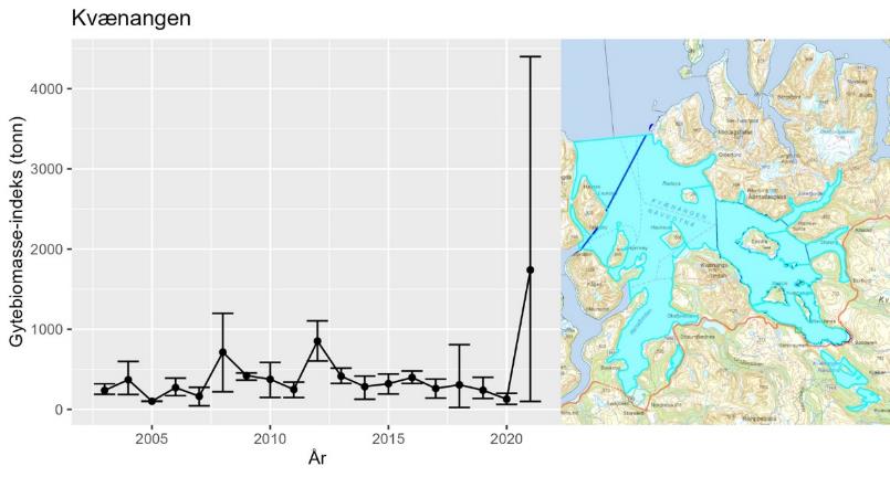
Utviklingen i gytebiomasse-indeks i Kvænangen har ingen tydelig trend (Figur 24). Estimatet av gytebiomasse fra 2021 har særlig høy usikkerhet, noe som skyldes at det ble registrert en uvanlig stor mengde stor torsk på en stasjon i stratumet.
Det er rapportert om gytende torsk i Lopphavet rett utenfor Kvænangen, men det er ukjent om det er skrei eller kysttorsk som gyter der.
Det foreligger konserverte eggprøver fra flere år som kan analyseres med hensikt på å indentifisere andelen kysttorsk/skrei.
Det er ikke kjent om kysttorsken som gyter i området er stasjonær eller migrerende.
6.2 - Kommersiell fiskeriaktivitet
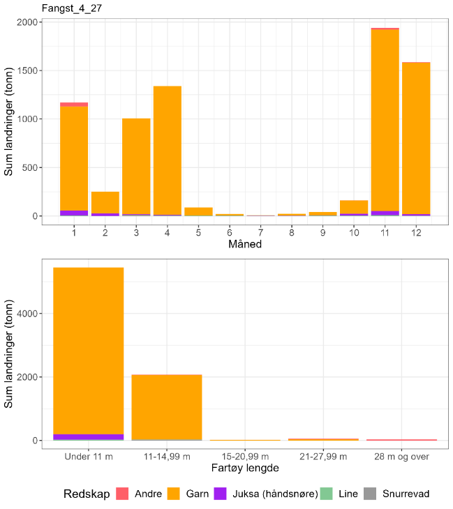
I lokasjon 4-27, der det aktuelle gytefeltet inngår, tas de største mengdene torsk med garn i november og desember (Figur 25). Det tas også store mengder med garn i første kvartal som inkluderer gytetiden. Fartøy < 15 m dominerer ladningene, og da særlig de minste fartøyene (Figur 25). Det er lite fangst med andre redskap i området. Basert på biologisk prøvetaking fiskes det en blanding av skrei og kysttorsk i lokasjonen, men kysttorsk dominerer i de fleste måneder unntatt april (i denne måneden foreligger det relativt få prøver, Tabell 10). Merk den høye andelen kysttorsk (80-90 %) i november-desember-landingene 2018-2022.
Fiskeriaktiviteten (samlet for alle arter) er høy i hele lokasjonen. I tillegg til fiske med konvensjonelle redskap reflekterer Figur 23 i stor grad også fiske etter reke (bunntrål) og sild (not). Rundt 1000 tonn torsk ble fanget på selve gytefeltet i perioden 2018-2021 (Tabell 11), noe som betyr at dette gytefeltet med stor margin har størst fangst av alle felt presentert i denne rapporten. Fangsten på gytefeltet utgjør omtrent 16 % av torskefangstene i lokasjonen i samme periode.
| Måned | Antall kysttorsk i prøve-materiale | Antall skrei i prøve-materiale | Totalt | Andel kysttorsk | Sum sluttseddelvekt (kg) torsk 2018-2022 | Herav kysttorsk (kg) |
| 1 | 0 | 2 | 2 | Ingen data | 1170786 | Ingen data |
| 2 | 0 | 0 | 0 | Ingen data | 250666 | Ingen data |
| 3 | 188 | 12 | 200 | 0,94 | 1007106 | 946680 |
| 4 | 2 | 18 | 20 | 0,10 | 1338696 | 133870 |
| 5 | 0 | 0 | 0 | Ingen data | 87031 | Ingen data |
| 6 | 0 | 0 | 0 | Ingen data | 20057 | Ingen data |
| 7 | 9 | 0 | 9 | 1 | 6383 | 6383 |
| 8 | 0 | 0 | 0 | Ingen data | 23767 | Ingen data |
| 9 | 27 | 0 | 27 | 1 | 39985 | 39985 |
| 10 | 934 | 67 | 1001 | 0,93 | 160544 | 149799 |
| 11 | 454 | 64 | 518 | 0,88 | 1940799 | 1701009 |
| 12 | 64 | 15 | 79 | 0,81 | 1585957 | 1284826 |
| Fangst torsk gyte-område | Fangst sei gyte-område | Fangst hyse gyte-område | Fangst torsk lokasjon | Fangst sei lokasjon | Fangst hyse lokasjon | Prosent fangst i gyte-område torsk | Prosent fangst i gyte-område sei | Prosent fangst i gyte-område hyse | Prosent fangst i sluttseddel uten sporing (alle arter) |
| 1026 | 366 | 9 | 6438 | 2959 | 68 | 16 | 12 | 13 | 15 |
6.3 - Rekreasjonsfiske
Fullstendige data på innsats og uttak i rekreasjonsfiske mangler for området.
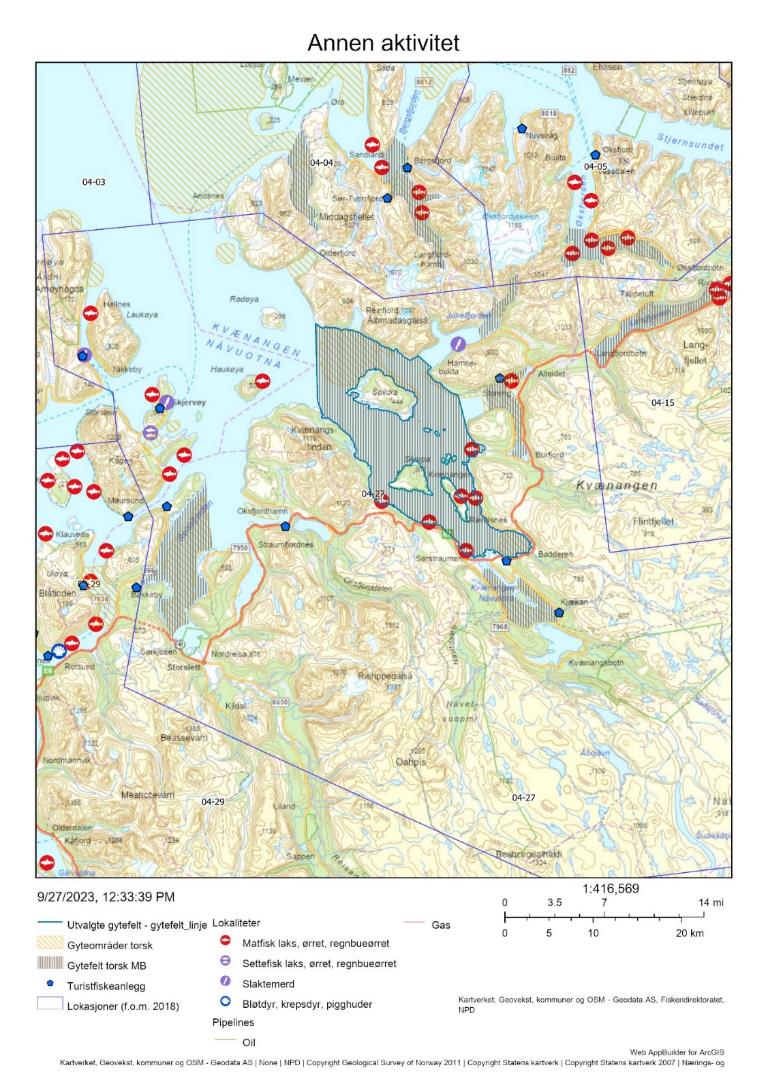
Det er registrert syv turistfiskebedrifter i lokasjonen, hvorav tre ligger innenfor eller i tilknytting til gytefeltet (Figur 26).
6.4 - Annen menneskelig aktivitet i området
Kvænangen og Reisafjorden har begge status som Nasjonale laksefjorder (særlig beskyttet område for villaks). Det er allikevel flere oppdrettsanlegg for laks/regnbuørret/ørret i området (Figur 26). Disse har en samlet kapasitet på 46 380 tonn, hvorav 24 300 tonn er plassert innenfor det aktuelle gytefeltet for kysttorsk.
6.5 - Samlet vurdering av menneskelig aktivitet
6.5.1 - Oppsummering av aktivitet
6.5.1.1 - Gytefeltet
På dette gytefeltet fiskes det både torsk og sei med garn fra fartøy < 11 m. Gytefeltet er rangert på plass 3/22 i forhold til andelen torskefangst som tas innenfor gytefeltet, og på første plass i forhold til kvantum fanget på gytefeltet (Vedlegg 1 og 2). Det anslåtte uttaket på vel 1 000 tonn i perioden 2018-2022 virker høyt sett opp mot biomasse-indeksen av kysttorsk i hele lokasjonen, som hvis man ser bort fra det svært usikre estimatet fra 2021 har blitt estimert til 130-300 tonn årlig i perioden. Det bør tas høyde for at det reelle uttaket på feltet er enda større siden turist- og fritidsfisket ikke er tatt med i beregningene. Det er relativt stor oppdrettsaktivitet i gytefeltet (laksefisk), til tross for at Kvænangen er en Nasjonal laksefjord. Det er et mindre antall turistfiskebedrifter i tilknytting til gytefeltet.
6.5.1.2 - Lokasjonen - innenfor og utenfor fjordlinjen
Mesteparten av lokasjonen ligger innenfor fjordlinjen. Det foregår et blandingsfiske på kysttorsk og skrei i gytetiden. Kvantum kysttorsk som fanges i lokasjonen er rangert på plass 20 av 563 lokasjoner på kysten der det fiskes torsk (Vedlegg 2 og 3), og området er derfor viktig også sett opp mot totalfangsten av kysttorsk i det nordlige bestandsområdet. Anslagsvis 5 000 tonn kysttorsk ble fanget i Kvænangen i perioden 2018-2022. Dette tallet er ikke et offisielt estimat, men et anslag basert på data presentert i Tabell 10 og følgende antakelser: 1) 50 % av fangsten i januar og februar er kysttorsk, og 2) all torsk fanget i mai, juni og august er kysttorsk. For å vurdere om dette uttaket er høyt sett opp mot gytebiomasseindeksen for stratum Kvænangen gjøres følgende tankeeksperiment. Anslaget på 130-300 tonn er en indeks som antas å være proporsjonal mot gytebiomassen på bestandsnivå. Som et grovt anslag har den totale gytebiomassen i toktet nord for 67°N blitt estimert til mellom 11 % og 18 % av gytebiomassen i bestanden i perioden 2018-2021. Ved å anta at disse tallene kan overføres til Kvænangen oppnås følgende maks- og minimumsanslag på årlig gytebiomasse: 1) i underkant av 3 000 tonn (ved 300 tonn gytebiomasseindeks som utgjør 11 % av den totale gytebiomassen i området), 2) 700 tonn (ved 130 tonn gytebiomasseindeks der dette utgjør 18 % av total gytebiomasse i området). Det er altså stor usikkerhet i hvor stor gytebiomassen er, der det laveste anslaget innebærer et høyt fiskepress som ikke kan anses å være bærekraftig. Det understrekes at ovenstående er grove anslag, at gytebiomasseindeksen er målt om høsten, at de kommersielle fangstene ikke bare består av gytemoden fisk, og at det totale uttaket også vil være avhengig av fangster i turist- og fritidsfiske.
6.5.2 - Konklusjon
Fisket i Kvænangen fremstår som en viktig kilde til fiskedødelighet for kysttorsk i nord, og overordnet vurderes den menneskelige aktiviteten i form av fiske til å være høy i gyteområdet. Det er svært høy fiskeriaktivitet både i lokasjonen og lengre ut på kysten, både med konvensjonelle redskaper og med trål og snurpenot. Det tilrås som et minimumstiltak at fisket reduseres kraftig i gytetiden på selve gytefeltet, og gjerne i hele lokasjonen. Det vises også til de store torskefangstene i oktober-november som domineres av kysttorsk. Dette er et relativt nytt fiskemønster til følge av at silden har kommet inn for overvintring i området, etterfølgt av torsk og sei som kan være annen fisk enn den som vanligvis oppholder seg i området. Dette gjør det ekstra vanskelig å vurdere fiskepresset opp mot toktindeks, men overordnet tilsier de store fangsttallene at en redusert torskefangst i lokasjonen kan gi utslag på bestandsnivå for den nordlige kysttorskbestanden, der fangsten i henhold til kvoterådet bør reduseres med omtrent 40 %.
7 - Storfjorden, Troms
Posisjon: 69°24’54’’N 20°11’54’’E; lokref: 4-29

7.1 - Beskrivelse av området
Gytefeltet Storfjorden i indre Lyngen er klassifisert som et regionalt viktig gytefelt (B5) grunnet høy eggtetthet og noe retensjon av eggene, og området ble identifisert som gytefelt både i Havforskningsinstituttet sine eggundersøkelser og i Fiskeridirektoratets intervjuundersøkelser med fiskere (Figur 28). Gyteområde for skrei er identifisert lengre ut på kysten, fra Nord-Fugløya og vestover mot Senja (utenfor lokasjonen).
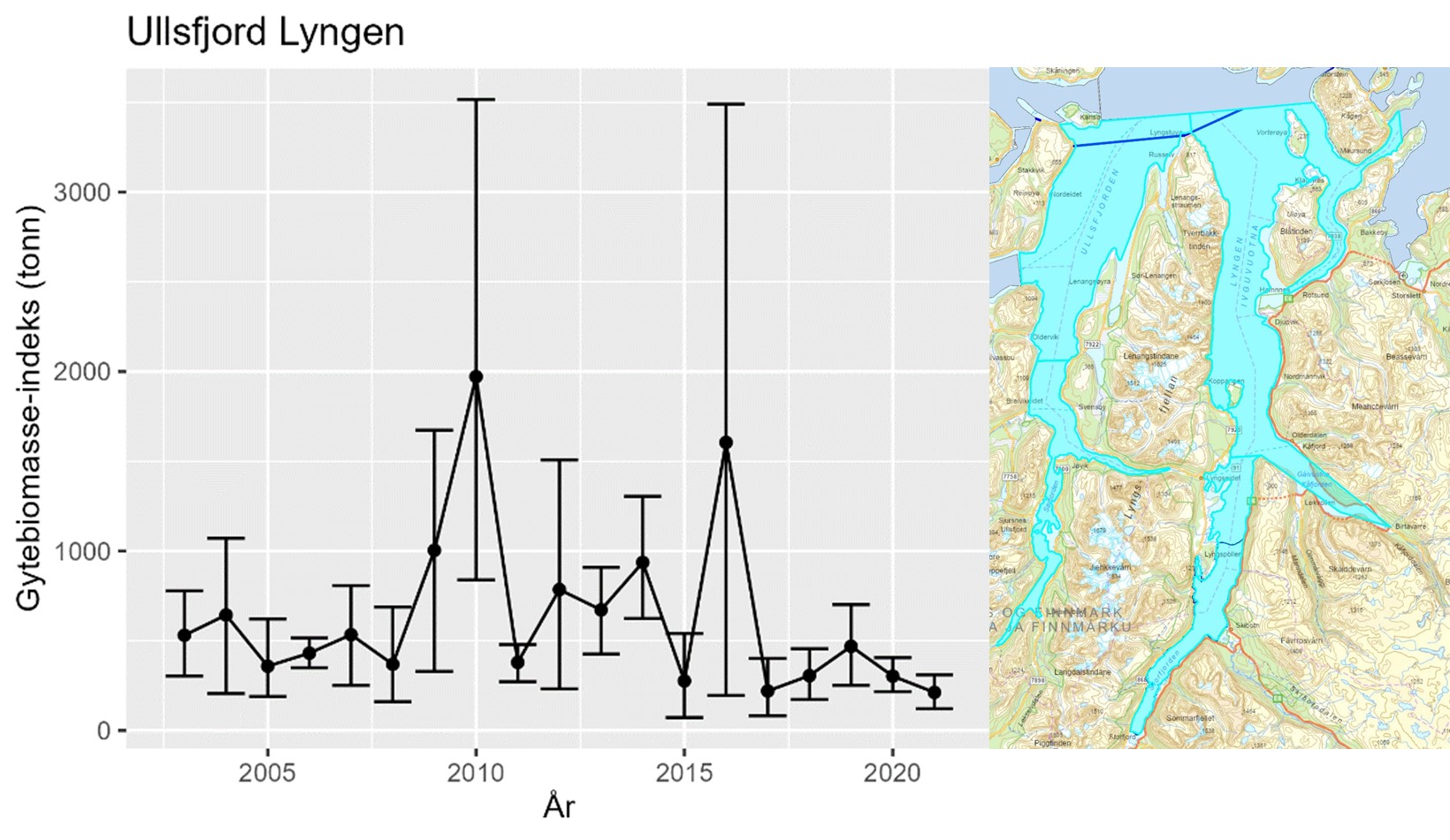
Utviklingen i gytebiomasse-indeks i området som dekker både Ullsfjorden og Lyngen (lokasjon 04-28 og 04-29, se Figur 29), og inkluderer begge gytefelt, minner om utviklingen for hele bestanden nord for 67°N; det var en topp-periode mellom 2009-2016 (opptil over 1000 tonn), med en lavere periode før (ca 500 tonn), og særlig etter 2016 (ca 250 tonn) (Figur 29). Ekstra stor usikkerhet i topp årene skyldes stor variasjon i trålfangster mellom ulike deler av området.
Det foreligger konserverte eggprøver fra flere år som kan analyseres med hensikt på å indentifisere andelen kysttorsk/skrei i gyteområdet.
Det er ikke kjent om kysttorsken som gyter i området er stasjonær eller migrerende
7.2 - Kommersiell fiskeriaktivitet
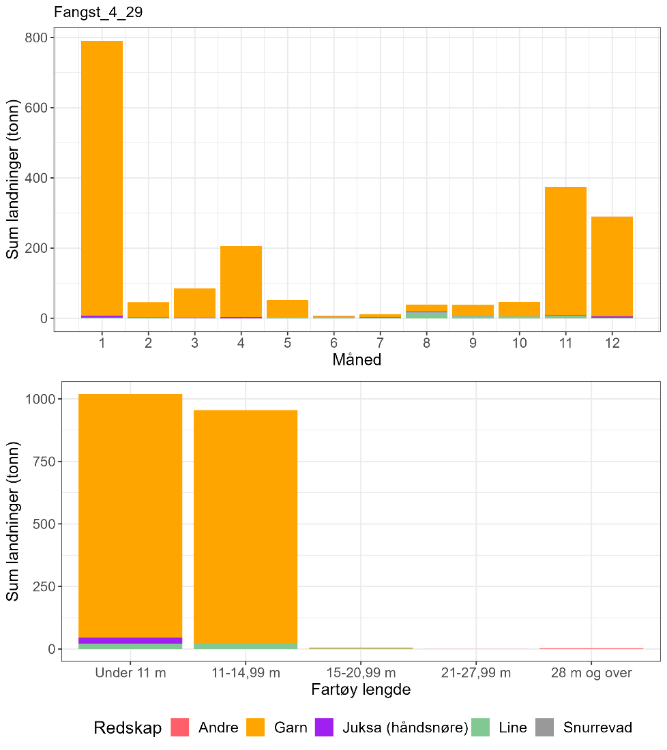
I lokasjonen skjer den mest intensive fiskeriaktiviteten i de ytre områdene fra Uløya og nordover mot Fugløysundet (Figur 27). Det kunne også spores aktivitet innover Lyngen, mens ingen fiskeriaktivitet er registrert i selve gyteområdet (Figur 27). Torskefisket i lokasjonen har en tydelig topp i januar, når det tas relative store mengder fra fartøy < 15 m, men det er også aktivitet utover gytesesongen og i november-desember (Figur 30). Fisket foregår nesten utelukkende med garn (Figur 30). Prøver for å anslå andelen kysttorsk foreligger bare fra mars (svært få) og oktober (Tabell 12), og viser en høy andel kysttorsk. Gitt nærheten til skreiområder lengre ut på kysten er det allikevel trolig at både skrei og kysttorsk fanges her, særlig i starten av året.
Fangsten av torsk, hyse og sei i selve gyteområdet er svært liten (Tabell 13).
| Måned | Antall kysttorsk i prøve-materiale | Antall skrei i prøve-materiale | Totalt | Andel kysttorsk | Sum sluttseddelvekt (kg) torsk 2018-2022 | Herav kysttorsk (kg) |
| 1 | 0 | 0 | 0 | Ingen data | 790054 | Ingen data |
| 2 | 0 | 0 | 0 | Ingen data | 45539 | Ingen data |
| 3 | 6 | 0 | 6 | 1 | 84793 | 84793 |
| 4 | 0 | 0 | 0 | Ingen data | 204927 | Ingen data |
| 5 | 0 | 0 | 0 | Ingen data | 51926 | Ingen data |
| 6 | 0 | 0 | 0 | Ingen data | 6982 | Ingen data |
| 7 | 0 | 0 | 0 | Ingen data | 11842 | Ingen data |
| 8 | 0 | 0 | 0 | Ingen data | 38905 | Ingen data |
| 9 | 0 | 0 | 0 | Ingen data | 38713 | Ingen data |
| 10 | 638 | 31 | 669 | 0,95 | 46384 | 44234 |
| 11 | 0 | 0 | 0 | Ingen data | 373781 | Ingen data |
| 12 | 0 | 0 | 0 | Ingen data | 289727 | Ingen data |
| Fangst torsk gyte-område | Fangst sei gyte-område | Fangst hyse gyte-område | Fangst torsk lokasjon | Fangst sei lokasjon | Fangst hyse lokasjon | Prosent fangst i gyte-område torsk | Prosent fangst i gyte-område sei | Prosent fangst i gyte-område hyse | Prosent fangst i sluttseddel uten sporing (alle arter) |
| 0 . 14 | 0.17 | 0 | 1783 | 1604 | 140 | < 0.1 | < 0.1 | 0 | 12 |
7.3 - Rekreasjonsfiske
Fullstendige data på innsats og uttak i rekreasjonsfiske mangler for området.
Det er registrert 11 turistfiskebedrifter i lokasjonen, hvorav to ligger innenfor eller i tilknytting til gytefeltet (Figur 31).
7.4 - Annen menneskelig aktivitet i området
Det er flere oppdrettsanlegg for laks/regnbuørret/ørret i ytre deler av lokasjonen (Figur 31). Disse har en samlet kapasitet på 55 690 tonn. Det er ingen oppdrettsanlegg i sjø i tilknytting til gytefeltet.
7.5 - Samlet vurdering av menneskelig aktivitet
7.5.1 - Oppsummering av aktivitet
7.5.1.1 - Gytefeltet
Basert på fiskeriaktiviteten som kunne spores så fiskes det i stort sett ikke torsk på selve gytefeltet. Gytefeltet er rangert på nest siste plass i forhold til andel og kvantum fangst i gytefeltet (Vedlegg 1 og 2). Det bør allikevel tas høyde for at det reelle uttaket kan være større siden omfanget av turist- og fritidsfisket er ukjent og det ligger turistfiskebedrifter i tilknytting til gytefeltet. Det er ingen oppdrettsanlegg i sjø innenfor gytefeltet.
7.5.1.2 - Lokasjonen - innenfor og utenfor fjordlinjen
Mesteparten av lokasjonen ligger innenfor fjordlinjen. Det anslåtte kvantumet av kysttorsk fanget i lokasjonen er rangert på plass 36 av 563 lokasjoner på kysten det det fiskes torsk (Vedlegg 2). Fangsten på omtrent 2000 tonn torsk samlet for perioden 2018-2022, der en ukjent andel er kysttorsk, kan være betydelig sett opp mot en gytebiomasseindeks av kysttorsk på ca. 250 tonn årlig målt om høsten. Det er dokk trolig at en god del av fangsten i starten av året består av skrei og ev. kysttorsk som vandrer inn fra andre områder, men her er datagrunnlaget for svakt for å konkludere sikkert. Seifangstene i lokasjonen er omtrent like store som torskefangstene, mens hysefangstene er mye lavere. Det er relativt stor oppdrettsaktivitet i de nordlige delene av lokasjonen.
7.5.2 - Konklusjon
Uttaket av torsk i lokasjonen er relativt høyt, men det er usikkert hvor stor andel som er kysttorsk. Koblingen mot sporingsdata tilsier at det ikke foregår fiske etter torsk på selve gytefeltet, men det er en betydelig fiskeriaktivitet lengre ut i fjorden. Det kan derfor være aktuelt å verne et ev. innsig til gytefeltet i første kvartal. Generelt er det behov for å øke kunnskapen om andelen kysttorsk i området, og da særlig i forhold til fisket i første kvartal.
8 - Balsfjorden, Troms
Posisjon: 69°17'30"N 19°22'18"E; lokref: 5-39
8.1 - Beskrivelse av området
Gytefeltet innerst i Balsfjorden er klassifisert som regionalt viktig (B5) grunnet middels eggtetthet og høy retensjon. Området har blitt identifisert som gytefelt både i Havforskningsinstituttet sine undersøkelser og i Fiskeridirektoratets intervjuundersøkelser av fiskere. I lokasjonen finnes i tillegg et lokalt viktig gytefelt i fjordarmen Ramfjorden, og et intervju-basert felt lengre nord i Grøtsundet der det er registrert både skrei og kysttorsk (se Figur 35). I ytre kystområder utenfor Balsfjorden er det gyteområde og beiteområde for skrei.
I Balsfjorden er det kartlagt flere bløtbunns- og ålegressområder, naturtyper som en klassifisert som svært viktige og som kan være viktige oppvekstområder for torsk og annen bunnfisk. Noen av disse områdene overlapper med det aktuelle gytefeltet.
Utviklingen i toktindeks i området minner om utviklingen for hele bestanden nord for 67°N, men estimatene i perioden med høyest gytebiomasseindeks har relativt stor usikkerhet grunnet stor variasjon i trålfangstene innenfor stratumet. Siden toppen i 2016 har det vært en nedadgående trend i gytebiomassen (Figur 33).
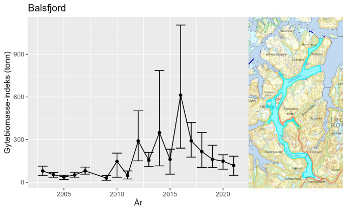
Det foreligger konserverte eggprøver fra gytefeltet som kan analyseres med hensikt på å indentifisere andelen kysttorsk/skrei.
Det er ikke kjent om kysttorsken som gyter i området er stasjonær eller migrerende.
8.2 - Kommersiell fiskeriaktivitet
I perioden 2018-2022 er det registrert fangst i lokasjonen i alle måneder, med en totalfangst på omtrent 150 tonn. Det er en topp i fangstene i gytetiden (mars-april), da mesteparten av torsken fanges med garn og juksa fra fartøy < 11 m (Figur 34). Det tas også en del torsk med line og juksa i januar-februar, samt utover sensommeren og høsten (Figur 34). Mesteparten av torsken som fanges i denne lokasjonen kan antas å være kysttorsk, både i og utenfor gytetiden (Tabell 14). Fangsten av torsk innenfor selve gyteområdet er estimert til omtrent 12 % av torskefangsten i lokasjonen (Tabell 15).
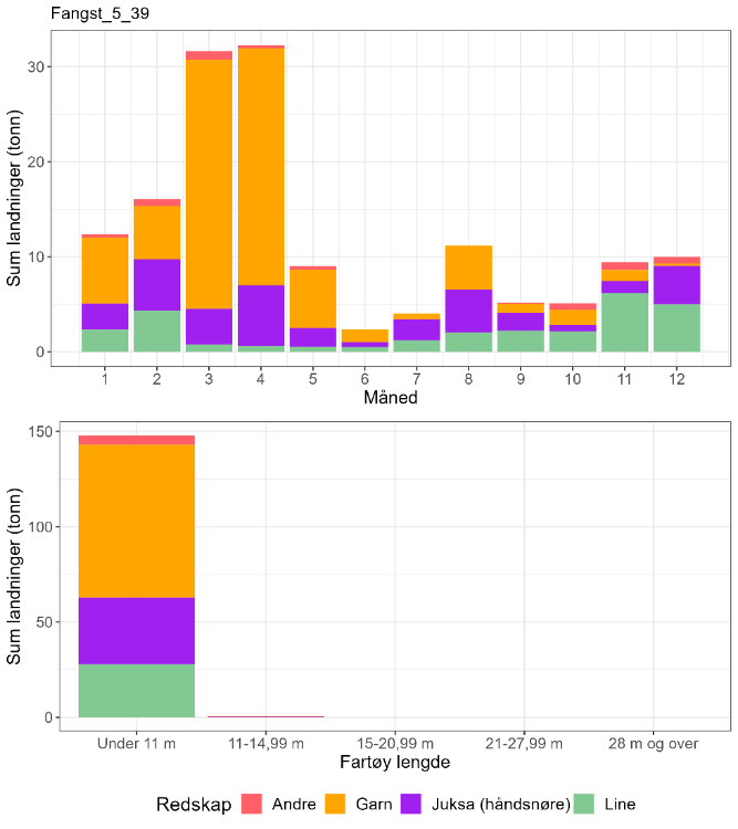
| Måned | Antall kysttorsk i prøve-materiale | Antall skrei i prøve-materiale | Totalt | Andel kysttorsk | Sum sluttseddelvekt (kg) torsk 2018-2022 | Herav kysttorsk (kg) |
| 1 | 0 | 0 | 0 | Ingen data | 12349 | Ingen data |
| 2 | 0 | 0 | 0 | Ingen data | 16052 | Ingen data |
| 3 | 100 | 1 | 101 | 0,99 | 31645 | 31332 |
| 4 | 3 | 0 | 3 | 1 | 32256 | 32256 |
| 5 | 9 | 1 | 10 | 0,90 | 9021 | 8119 |
| 6 | 0 | 0 | 0 | Ingen data | 2338 | Ingen data |
| 7 | 46 | 0 | 46 | 1 | 4034 | 4034 |
| 8 | 4 | 0 | 4 | 1 | 11150 | 11150 |
| 9 | 0 | 0 | 0 | Ingen data | 5159 | Ingen data |
| 10 | 399 | 25 | 424 | 0,94 | 5099 | 4798 |
| 11 | 0 | 0 | 0 | Ingen data | 9416 | Ingen data |
| 12 | 0 | 0 | 0 | Ingen data | 10001 | Ingen data |
| Fangst torsk gyte-område | Fangst sei gyte-område | Fangst hyse gyte-område | Fangst torsk lokasjon | Fangst sei lokasjon | Fangst hyse lokasjon | Prosent fangst i gyte-område torsk | Prosent fangst i gyte-område sei | Prosent fangst i gyte-område hyse | Prosent fangst i sluttseddel uten sporing (alle arter) |
| 12 | 0 | 4.2 | 100 | 26 | 26 | 12 | 0 | 16 | 26 |
8.3 - Rekreasjonsfiske
Data på innsats og uttak i rekreasjonsfiske mangler for området.
Det er registrert 11 turistfiskebedrifter i lokasjonen, hvorav en er plassert i Balsfjorden utenfor gyteområdet (Figur 35).
8.4 - Annen menneskelig aktivitet i området
Det er ingen akvakultur i sjø i selve gyteområdet eller i andre deler av Balsfjorden (Figur 35). Det er flere anlegg lengre nord i lokasjonen (nordøst for Tromsø), som har en samlet kapasitet på 17 880 tonn laks/regnbueørret/ørret. Det er også noe oppdrett av fisk og bløtdyr samt dyrking av alger på forskningsstasjoner i lokasjonen.
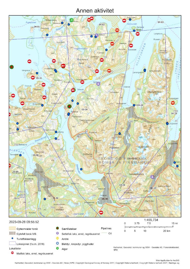
8.5 - Samlet vurdering av menneskelig aktivitet
8.5.1 - Oppsummering av aktivitet
8.5.1.1 - Gytefeltet
Det foregår et garnfiske etter torsk på gytefeltet i gytetiden fra fartøy < 11 m. Gytefeltet er rangert på plass 5/22 i forhold til andelen fangst av total torskefangst i lokasjonen som tas innenfor det utvalgte gytefeltet, og plass 12/22 i forhold til kvantum fanget på gytefeltet (Vedlegg 1 og 2). Det anslåtte uttaket på 12 tonn i perioden 2018-2021 er lavt sett opp mot biomasse-indeksen av kysttorsk i området. Det bør allikevel tas høyde for at det reelle uttaket er større når det ikke-kvantifiserte turist- og fritidsfisket tas med i beregningene, og for at toktmålingene indikerer en negativ utvikling. Det er ingen oppdrettsanlegg i sjø innenfor gytefeltet.
8.5.1.2 - Lokasjonen - innenfor og utenfor fjordlinjen
Hele lokasjonen ligger innenfor fjordlinjen. Det anslåtte kvantumet av kysttorsk fanget i lokasjonen er rangert på plass 106 av 563 lokasjoner på kysten det det fiskes torsk (Vedlegg 2). Fangsten på i underkant av 150 tonn torsk samlet for perioden 2018-2022, hvorav mesteparten er anslått til å være kysttorsk, vurderes å være lav sett opp mot en årlig gytebiomasseindeks på 100-150 tonn for området Balsfjord-Kvalsundet-Grøtsundet-Langsundet (som anslås til å utgjøre 10-20 % av den reelle gytebiomassen, se avsnittet om toktindeks i innledningen). Det bør allikevel tas høyde for at det reelle uttaket er større når det ikke-kvantifiserte turist- og fritidsfisket tas med i beregningene, og for at toktmålingene indikerer en negativ utvikling. Hyse- og seifangstene i lokasjonen utgjør omtrent halvparten av torskefangstene. Oppdrettsanlegg for blant annet laksefisk overlapper med gytefeltene i de nordlige delene av lokasjonen.
8.5.2 - Konklusjon
Det foregår et lite fiske etter gytende torsk i Balsfjorden, men overordnet vurderes den menneskelige aktiviteten til å være forholdsvis lav i gyteområdet. Den negative utviklingen i toktindeks i lokasjonen tilsier at torskefisket bør holdes på et lavt nivå også fremover, særlig i selve gyteområdet.
9 - Finnfjorden – Lavangen – Gratangen, Troms
Posisjon: 69˚10.3’N 17˚58.4’E/ 68˚47.8’N 17˚36.5’E/ 68˚43.2’N 17˚26.6’E; lokref: 5-41
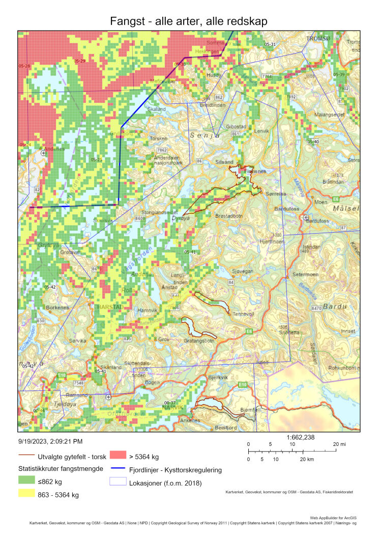
9.1 - Beskrivelse av området
Området inkluderer gytefeltene Finnfjorden, Lavangen og Gratangen. Gytefelt Finnfjorden ble under gytefeltkartleggingen i 2011 klassifisert som et nasjonalt viktig gytefelt (A6) med mye egg (3) og stor tilbakeholdelse av egg (3). De to andre gyteområdene, Lavangen og Gratangen, ble klassifisert som regionalt viktige gytefelt (B5) med middels antall egg (2), men med stor grad av tilbakeholdelse av egg (3), dvs. at mye av eggene ble værende og klekket i gyteområdene. Finnfjorden og Gratangen (også et lite felt i Lavangen) ble også registrert som gyteområder i forbindelse med Fiskeridirektoratets gytefeltkartlegging basert på intervjuundersøkelser med fiskere.
Havforskningsinstituttet besøkte igjen gytefeltene til torsk i indre fjordstrøk i Troms i gytetiden 2021. Figur 37 viser resultat fra denne kartleggingen. Torskeeggene er enda ikke analysert og identifisert til kysttorsk eller skrei. Figuren viser noen forskjeller i forhold til 2011, bl.a. så fikk ikke Gratangen (område 6 i Figur 37) samme verdi i 2021 som i 2011. Årsakene kan være flere, bl.a. hvor på gytekurven man var da egg-innsamlingen foregikk, variasjoner i gytefeltpreferanse, eller endringer i gytepopulasjonene i løpet av ti-års perioden. Prinsippet er altså at hvis vi finner egg på et sted mange flere år på rad så styrker det verdien av gytefeltet. Hvis vi finner egg bare det ene året, kan vi ikke si at det IKKE er et gytefelt, men det kan være et gytefelt med noe mer variasjon i eggproduksjon (undersøkelsene vi gjør er jo et «snapshot» av et stort område der hver stasjon bare tas en gang). Dette viser at slike gytefeltkartlegginger bør gjøres jevnlig, og helst flere ganger i løpet av gyteperioden (se Borgundfjorden), for å kunne rangere den generelle viktigheten/verdien av gytefelt.
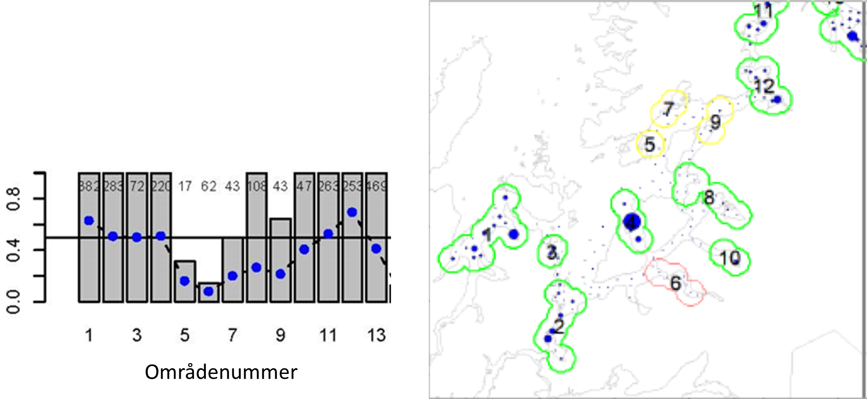
Figur 38 viser gytebiomasse av kysttorsk i Andfjorden/Vågsfjorden målt om høsten. Vi legger merke til den signifikante økningen i 2013-2016 til over 2000 tonn, men at det de siste årene har ligget på knapt 500 tonn.
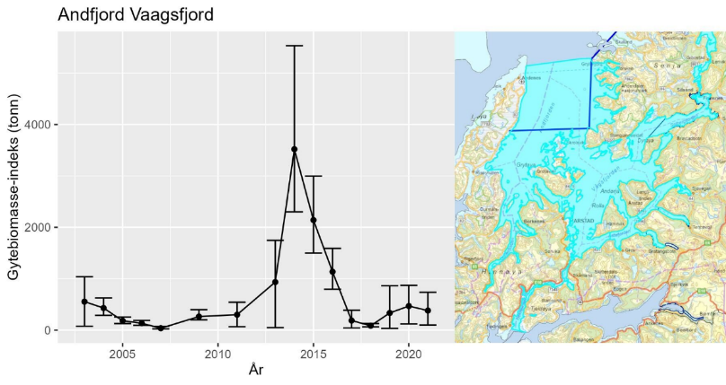
9.2 - Kommersiell fiskeriaktivitet
Det kommersielle torskefisket i lokasjonen (5-41) er fullstendig dominert av sesongfisket om vinteren fra og med januar til og med april (Figur 39). Det viser seg at sluttseddelstatistikken har store feil mht. fangstområde. Figuren viser flere landinger gjort av fartøy over 15 meter, og det er feil siden ingen fartøy over 15 meter har lov å fiske torsk innenfor fjordlinjene, og hele lokasjon 5-41 befinner seg innenfor. Det viste seg at store fangster hadde fått feil fangstområde; det rette er 5-31 utenfor fjordlinjene på yttersida av Senja. Denne feilen er ikke rettet opp tilbake i tid i sluttseddelstatistikken, men f.o.m. 2023 er dette rettet opp (se Figur 40).
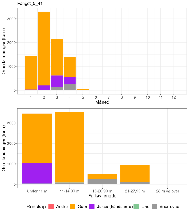
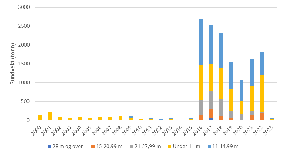
Basert på otolitt prøvemateriale 2018-2022 så viser Tabell 16 at det aller meste av torskefangstene i denne lokasjonen er kysttorsk, hele året. Når det gjelder fiskeaktivitet på selve gytefeltene så er det størst aktivitet på Finnfjorden-feltet, mens fiskeaktiviteten på Lavangen- og Gratangenfeltet ifølge Figur 36 er mye mindre.
| Måned | Antall kysttorsk i prøve-materiale | Antall skrei i prøve-materiale | Totalt | Andel kysttorsk | Sum sluttseddelvekt (kg) torsk 2018-2022 | Herav kysttorsk (kg) |
| 1 | 98 | 22 | 120 | 0,82 | 1438757 | 1174985 |
| 2 | 246 | 29 | 275 | 0,89 | 3299199 | 2951284 |
| 3 | 0 | 0 | 0 | Ingen data | 2161454 | Ingen data |
| 4 | 40 | 0 | 40 | 1 | 1405069 | 1405069 |
| 5 | 90 | 11 | 101 | 0,89 | 58137 | 51805 |
| 6 | 35 | 1 | 36 | 0,97 | 15367 | 14940 |
| 7 | 0 | 0 | 0 | Ingen data | 702 | Ingen data |
| 8 | 63 | 7 | 70 | 0,90 | 12337 | 11103 |
| 9 | 66 | 0 | 66 | 1 | 10267 | 10267 |
| 10 | 42 | 0 | 42 | 1 | 23769 | 23769 |
| 11 | 20 | 0 | 20 | 1 | 20609 | 20609 |
| 12 | 5 | 0 | 5 | 1 | 8815 | 8815 |
| Fangst torsk gyte-område | Fangst sei gyte-område | Fangst hyse gyte-område | Fangst torsk lokasjon | Fangst sei lokasjon | Fangst hyse lokasjon | Prosent fangst i gyte-område torsk | Prosent fangst i gyte-område sei | Prosent fangst i gyte-område hyse | Prosent fangst i sluttseddel uten sporing (alle arter) |
| 37 | 264 | 13 | 6625 | 1250 | 162 | 1 | 21 | 8 | 24 |
9.3 - Rekreasjonsfiske
Det er registrert ca 20 turistfiskeanlegg i lokasjonen (Figur 42). I Andfjordprosjektet til Fiskeridirektoratet, der HI har deltatt, har man gjennomgått turistfiske bedriftsregisteret i Andfjord-Vågsfjordområdet og sammenlignet egne intervjuer og egen prøvetaking med rapportert turistfiske fangst. Foreløpige tall for 2022 viser en underrapportering fra bedriftene; 69 tonn rapportert versus 97 tonn estimert torsk der det aller meste er kysttorsk (Figur 41). Undersøkelser av uttak i fritidsfiske ble gjennomført i Andfjorden sommeren 2023, men er ikke ferdig analysert.
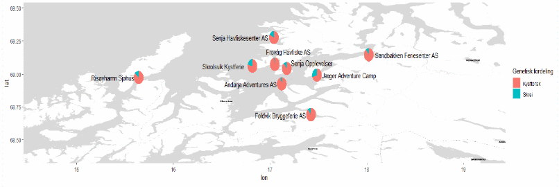
9.4 - Annen menneskelig aktivitet i området
Det er 38 oppdrettsanlegg for laks/regnbuørret/ørret i lokasjonen (Figur 42). Disse har en samlet kapasitet på ca 180 000 tonn. I tillegg er det registrert 3 oppdrettsanlegg for torsk og 2 tareanlegg.
4 oppdrettsanlegg for laks/regnbuørret/ørret og 1 torskeanlegg ligger inne på selve gyteområdet Finnfjorden. På gytefeltet Lavangen ligger det 2 oppdrettsanlegg for laks/regnbuørret/ørret, og i ytre del av gytefeltet Gratangen ligger det 1 oppdrettsanlegg for laks/regnbuørret/ørret.
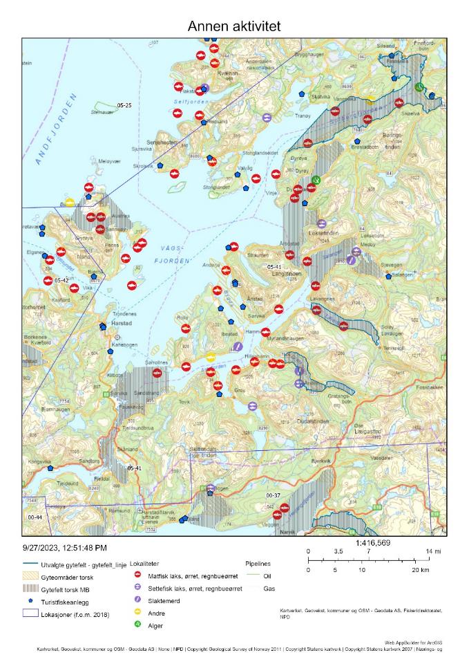
9.5 - Samlet vurdering av menneskelig aktivitet
9.5.1 - Oppsummering av aktivitet
9.5.1.1 - Gytefeltet
Det foregår et garnfiske etter torsk med fartøy < 15 meter på særlig to (Finnfjorden og Lavangen) av de tre gytefeltene i de fire første månedene av året. Gytefeltene er rangert på plass 15/22 i forhold til andelen fangst av total torskefangst i lokasjonen som tas innenfor de utvalgte gytefeltene, og plass 8/22 i forhold til kvantum fanget på gytefeltet (Vedlegg 1 og 2). Det anslåtte uttaket på 37 tonn i perioden 2018-2021 er lavt sett opp mot biomasse-indeksen av kysttorsk i området. Det bør allikevel tas høyde for at det reelle uttaket er større når turist- og fritidsfisket tas med i beregningene. Det er til sammen 8 oppdrettsanlegg i sjø innenfor de tre gytefeltene, herav 1 torskeanlegg.
9.5.1.2 - Lokasjonen - innenfor og utenfor fjordlinjen
Hele lokasjonen ligger innenfor fjordlinjen. Det anslåtte kvantumet av kysttorsk fanget i lokasjonen er rangert på plass 13 av 563 lokasjoner på kysten det det fiskes torsk (Vedlegg 2). Dette er nok et overestimat pga feil oppgitt fangstlokasjon. Oppgitt fangst på 6 625 tonn torsk samlet for perioden 2018-2022, hvorav mesteparten er anslått til å være kysttorsk, er et stort overestimat pga denne feilføringen, og det blir derfor umulig å vurdere beskatningen opp mot en årlig gytebiomasseindeks på knapt 500 tonn for hele Andfjorden og Vågsfjorden. Det er svært stor oppdrettsaktivitet i lokasjonen, og anlegg for både laksefisk og torsk overlapper med gytefeltene.
9.5.2 - Konklusjon
Den menneskelige aktiviteten vurderes å være høy i lokasjonen, og moderat i gytefeltene, men vurderingen på lokasjonsnivå er usikker grunnet feil i fiskeristatistikken. Det er helt avgjørende for en riktig vurdering av torskebeskatningen at fangstene blir statistikkført i riktig fangstlokasjon langs hele kysten. Registeret av turistfiskebedrifter må kontinuerlig oppdateres, og det må foretas stikkontroller av rapporteringen. Med så mange turistfiskebedrifter i en lokasjon/et område, så viser bl.a. Andfjord prosjektet at beskatningen fra disse bedriftene må tas med i det totale fangstregnskapet. Med flere oppdrettsanlegg lokalisert inne på gytefeltene så må miljøet rundt disse nøye overvåkes. HIs gytebiomasseserie for kysttorsk med start i 2003 vil være et viktig redskap for fremtidig overvåkning av kysttorsken i Andfjorden-Vågsfjorden.
10 - Rombaken, Ofotfjorden, Nordland
Posisjon: 68°27'54"N 17°34'42"E; lokref: 0-37
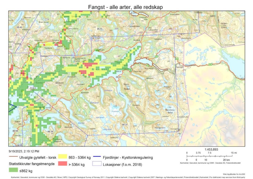
10.1 - Beskrivelse av området
Gyteområdet Rombaken ved Narvik er klassifisert som nasjonalt viktig (A6) grunnet høy eggtetthet og høy retensjon. Området har blitt identifisert i Havforskningsinstituttet sine eggundersøkelser og, i mindre omfang, i Fiskeridirektoratets intervjuundersøkelser med fiskere. Det er i tillegg identifisert flere lokalt og regionalt viktige gytefelt i andre armer til Ofotfjorden. Tvers over Vestfjorden ligger et av de viktigste gyteområdene for skrei, på sørsiden av Lofoten.
Tre svært viktige naturtyper forekommer i lokasjonen; bløtbunnsområder i strandsonen, skjellsand, og sterke tidevannsstrømmer. Det er ikke kartlagt slike områder i det utvalgte gytefeltet.
Det ble gjort DNA-analyser på egg samlet inn i gyteområdet under gytefeltskartleggingen i 2011-2012, med hensikt på å identifisere andelen kysttorsk/skrei. Omtrent halvparten av prøven var kysttorsk (Figur 44). Det er ikke kjent om kysttorsken som gyter i området er stasjonær eller migrerende, eller om skreieggene er et resultat av lokal gyting eller inndrift fra Lofoten.
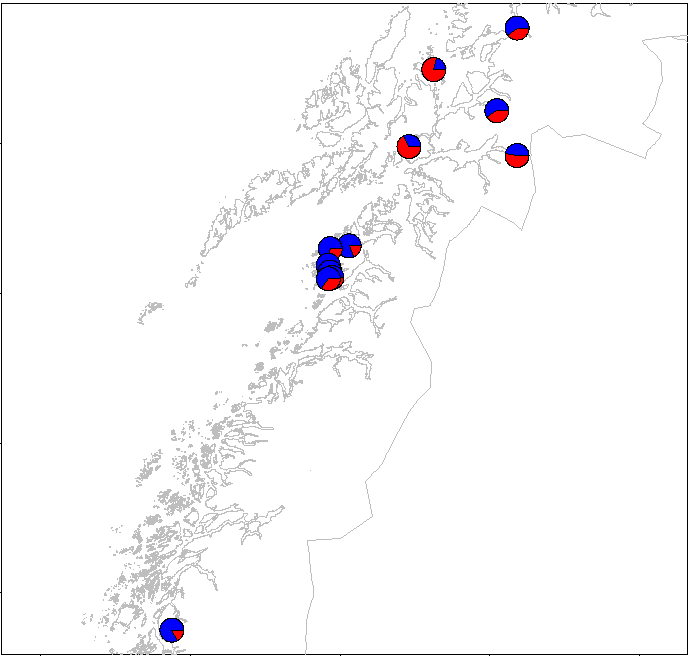
10.2 - Kommersiell fiskeriaktivitet
Det fiskes forholdsvis lite torsk i lokasjonen, men dette må ses i sammenheng med at lokasjonen er relativt liten. Torskefangsten har en topp i mars som domineres av linefiske fra fartøy i gruppen 11-15 m (Figur 45). Det er også registrert torsk i snurrevadfangster (fartøy > 28 m) denne tiden på året. Fisket er konsentrert i gytetiden, med lite aktivitet i mai-august og noe fiske med garn og line utover høsten (Figur 45). Det er tatt svært lite prøver fra lokasjonen; de eneste prøvene kommer fra januar, der andelen kysttorsk var i underkant av 90 % (Tabell 18). Basert på DNA-analysene (Figur 44) kan vi anta at andelen skrei – eller i hvert fall andelen skreiegg – er høyere i gytetiden.
Det er registrert svært lave torskefangster på selve gytefeltet, og små fangster av hyse og sei (Tabell 19).
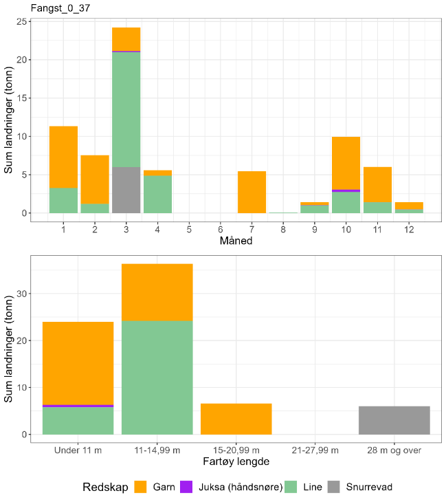
| Måned | Antall kysttorsk i prøve-materiale | Antall skrei i prøve-materiale | Totalt | Andel kysttorsk | Sum sluttseddelvekt (kg) torsk 2018-2022 | Herav kysttorsk (kg) |
| 1 | 35 | 5 | 40 | 0,88 | 11327 | 9911 |
| 2 | 0 | 0 | 0 | Ingen data | 7545 | Ingen data |
| 3 | 0 | 0 | 0 | Ingen data | 24211 | Ingen data |
| 4 | 0 | 0 | 0 | Ingen data | 5574 | Ingen data |
| 5 | 0 | 0 | 0 | Ingen data | 0 | Ingen data |
| 6 | 0 | 0 | 0 | Ingen data | 0 | Ingen data |
| 7 | 0 | 0 | 0 | Ingen data | 5461 | Ingen data |
| 8 | 0 | 0 | 0 | Ingen data | 44 | Ingen data |
| 9 | 0 | 0 | 0 | Ingen data | 1416 | Ingen data |
| 10 | 0 | 0 | 0 | Ingen data | 9932 | Ingen data |
| 11 | 0 | 0 | 0 | Ingen data | 6016 | Ingen data |
| 12 | 0 | 0 | 0 | Ingen data | 1410 | Ingen data |
| Fangst torsk gyte-område | Fangst sei gyte-område | Fangst hyse gyte-område | Fangst torsk lokasjon | Fangst sei lokasjon | Fangst hyse lokasjon | Prosent fangst i gyte-område torsk | Prosent fangst i gyte-område sei | Prosent fangst i gyte-område hyse | Prosent fangst i sluttseddel uten sporing (alle arter) |
| 0.3 | 5.3 | 0.2 | 62.2 | 886 | 53.7 | 0 | 1 | 0 | 11 |
10.3 - Rekreasjonsfiske
Data på innsats og uttak i rekreasjonsfiske mangler for området.
Det er registrert fire turistfiskebedrifter i lokasjonen, men ingen innenfor selve gytefeltet (Figur 46).
10.4 - Annen menneskelig aktivitet i området
Innenfor lokasjonen er det seks oppdrettsanlegg for laks/regnbueørret/ørret i sjø, med en samlet kapasitet på 17 920 t. Ingen av anleggene er plassert i det utvalgte gytefeltet, men to ligger i det lokalt viktige gytefeltet «Narvikbukt-Herjangsfjord» som grenser til Rombaken (Figur 46).
I fjorden rundt Narvik ligger flere skipsvrak fra andre verdenskrig, som fortsatt utgjører en viss risiko for oljeutslipp (Rinaldo et al., 2022).
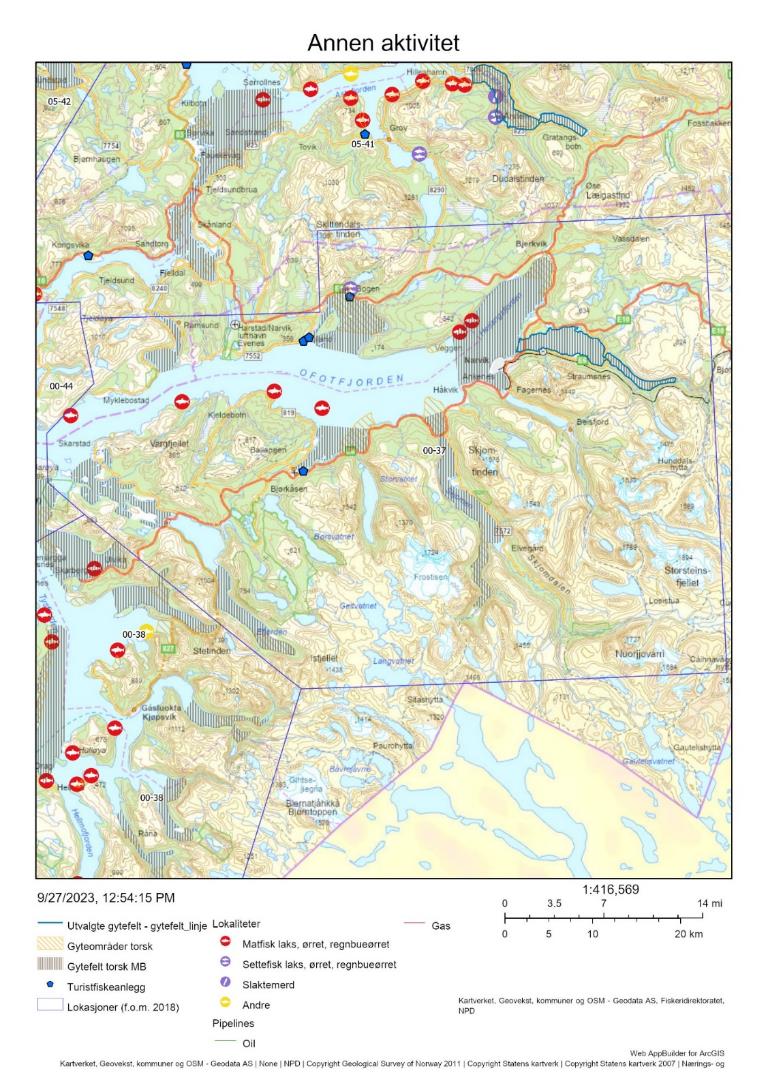
10.5 - Samlet vurdering av menneskelig aktivitet
10.5.1 - Oppsummering av aktivitet
10.5.1.1 - Gytefeltet
Av de 89 % av torskefangstene som kunne kobles til sporingsdata, var det svært små fangster som ble tatt på gytefeltet (300 kg i perioden 2018-2021, Tabell 19). Gytefeltet er derfor rangert på delt sisteplass i forhold til andelen fangst på gytefeltet og plass 18/22 i forhold til kvantum fanget på gytefeltet (Vedlegg 1 og 2). Det er mulig at turist- og fritidsfisket bidrar til et større uttak på gytefeltet. Det er ingen oppdrettsanlegg eller turistfiskebedrifter i selve gyteområdet.
10.5.1.2 - Lokasjonen – innenfor og utenfor fjordlinjen
Hele lokasjonen ligger innenfor fjordlinjen. Fiskeriaktiviteten (alle arter) er relativt høy i sentrale deler av lokasjonen, men ikke i fjordarmene der gytefelt for torsk har blitt identifisert (Figur 43). Det ble totalt fanget omtrent 60 tonn torsk i lokasjonen i perioden 2018-2021, hvorav 70 % ble tatt i januar-mars og resten fra juli-desember (Tabell 19, inkluderer ikke fangst fra fritids- og turistfiske). Det mangler data for å anslå andelen kysttorsk i disse fangstene. Oppdrettsanlegg for laksefisk er spredt utover fjorden og overlapper med et lokalt viktig gytefelt for torsk.
10.5.2 - Konklusjon
Det mangler informasjon om biomassen av kysttorsk i området. Samlet sett vurderes den menneskelige aktiviteten til å være lav i gyteområdet og moderat i lokasjonen som helhet, med et lavt uttak av torsk. Gitt at lokasjonen er relativt liten kan det allikevel ikke utelukkes at fiskedødeligheten kan være lokalt høy. Det foregår trolig gyting i store deler av lokasjonen. Lokasjonen ligger helt sør i det nordlige bestandsområdet og har nok mer til felles med det sørlige bestandsområdet (62-67°N) som er vurdert til å være i dårligere forfatning enn den nordlige bestanden. Det tilrås å følge med på utviklingen i torskefangst i området, som bør holdes på et lavt nivå.
11 - Hopen-Mørviksbotn og Øst av Sandvik, Nordfolda, Nordland
Posisjon: 67°45'42"N 15°38'42"E/ 67°25'47"N 15°32'13"E; lokref: 0-51
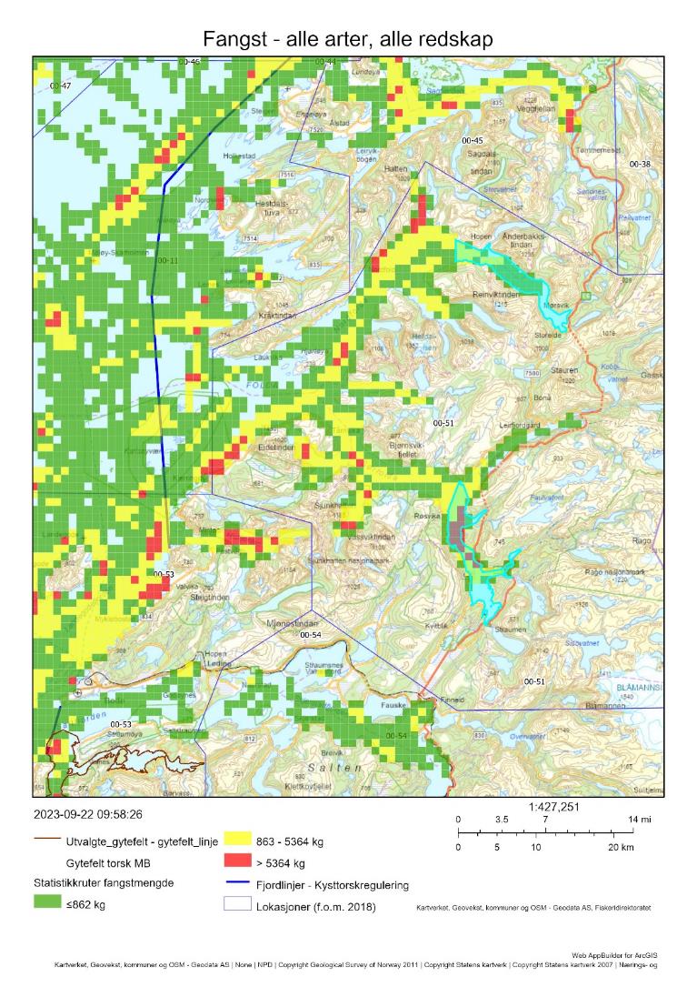
11.1 - Beskrivelse av området
Gyteområdene Hopen-Mørviksbotn og Øst av Sandvik er begge klassifisert som nasjonal viktige (A6) grunnet høye eggtettheter og god retensjon. Feltene har blitt identifisert i Havforskningsinstituttet sine eggundersøkelser og i Fiskeridirektoratets intervjuundersøkelser med fiskere. I Folda-området er det identifisert syv andre lokalt viktige gytefelt, og i tillegg har fiskere identifisert noen mindre områder utenom disse feltene. Det er altså sannsynlig at gyting foregår i store deler av Folda-området. Torsk gyter også på utsiden av Nordfolda/Steigen, der det er identifisert regional viktige gytefelt. På motsatt side av Vestfjorden ligger et av de viktigste gyteområdene for skrei, på sørsiden av Lofoten.
Lokasjonen har områder med bløtbunn i strandsonen og med skjellsand, to svært viktige naturtyper. Et av bløtbunnsområdene overlapper delvis med det sørlige gytefeltet (Øst av Sandvik).
Det ble gjort DNA-analyser på egg samlet inn på utsiden av Steigen under gytefeltskartleggingen i 2011-2012, med hensikt på å indentifisere andelen kysttorsk/skrei. Kysttorsk-egg dominerte i prøvene (Figur 48). Det foreligger konserverte eggprøver fra flere år som kan analyseres på samme måte.
Det er ikke kjent om kysttorsken som gyter i området er stasjonær eller migrerende
11.2 - Kommersiell fiskeriaktivitet
I lokasjon 0-51, der de aktuelle gytefeltene inngår, tas de største mengdene torsk med garn av fartøy < 11 m rett før og i gytetiden (februar-april, Figur 49). Det er også noe linefangst i gytetiden og i august-november. Prøvetakingen i området er mangelfull; de eneste prøvene i den aktuelle perioden er et lite antall otolitter fra oktober, som samtlige var fra kysttorsk (Tabell 20). Kombinert med DNA-analysene som viser at det er kysttorsk som gyter i området, er det grunn til å anta at mesteparten av fangsten i lokasjonen er kysttorsk. Den samlete fiskeriaktiviteten er større på det sørlige gytefeltet (Øst av Sandvik) enn i nord (Hopen-Mørviksbotn, Figur 47), men dette kan reflektere variasjon i seifangster som er relativt høye i lokasjonen (Tabell 21). Anslagsvis 2 % av torskefangstene ble tatt inne på de to gytefeltene, men dette estimatet har stor usikkerhet grunnet en høy andel landinger som ikke kunne kobles til sporingsdata (Tabell 21).
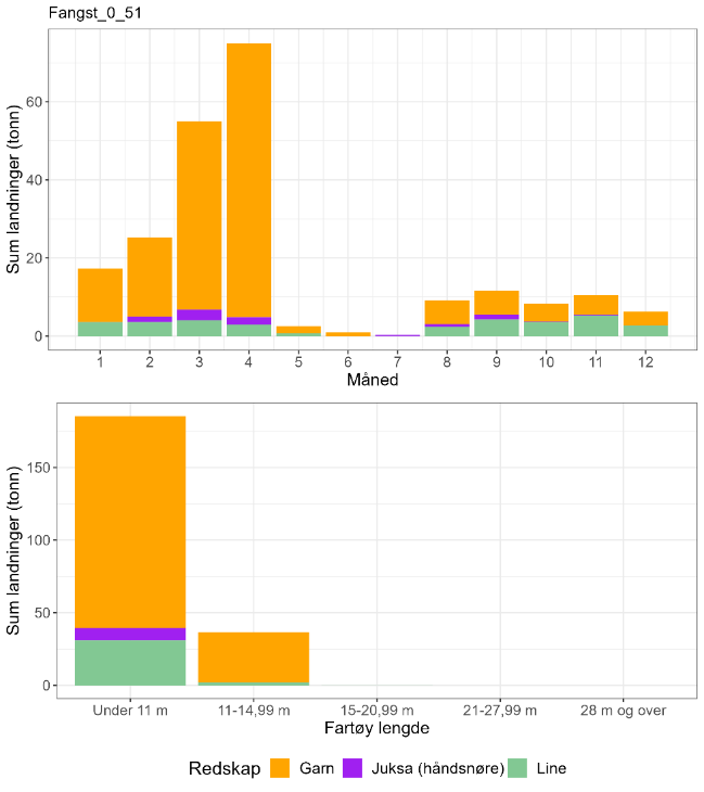
| Måned | Antall kysttorsk i prøve-materiale | Antall skrei i prøve-materiale | Totalt | Andel kysttorsk | Sum sluttseddelvekt (kg) torsk 2018-2022 | Herav kysttorsk (kg) |
| 1 | 0 | 0 | 0 | Ingen data | 17262 | Ingen data |
| 2 | 0 | 0 | 0 | Ingen data | 25268 | Ingen data |
| 3 | 0 | 0 | 0 | Ingen data | 54965 | Ingen data |
| 4 | 0 | 0 | 0 | Ingen data | 74987 | Ingen data |
| 5 | 0 | 0 | 0 | Ingen data | 2543 | Ingen data |
| 6 | 0 | 0 | 0 | Ingen data | 962 | Ingen data |
| 7 | 0 | 0 | 0 | Ingen data | 274 | Ingen data |
| 8 | 0 | 0 | 0 | Ingen data | 9149 | Ingen data |
| 9 | 0 | 0 | 0 | Ingen data | 11629 | Ingen data |
| 10 | 8 | 0 | 8 | Ingen data | 8317 | 8317 |
| 11 | 0 | 0 | 0 | Ingen data | 10442 | Ingen data |
| 12 | 0 | 0 | 0 | Ingen data | 6284 | Ingen data |
| Fangst torsk gyte-område | Fangst sei gyte-område | Fangst hyse gyte-område | Fangst torsk lokasjon | Fangst sei lokasjon | Fangst hyse lokasjon | Prosent fangst i gyte-område torsk | Prosent fangst i gyte-område sei | Prosent fangst i gyte-område hyse | Prosent fangst i sluttseddel uten sporing (alle arter) |
| 3.7 | 133 | 3.8 | 180 | 1577 | 85 | 2 | 8 | 4 | 60 |
11.3 - Rekreasjonsfiske
Data på innsats og uttak i rekreasjonsfiske mangler for området.
Det er ikke registrert noen turistfiskebedrifter i lokasjonen (Figur 50).
11.4 - Annen menneskelig aktivitet i området
Innenfor lokasjonen er det 18 oppdrettsanlegg for laks/regnbueørret/ørret i sjø, med en samlet kapasitet på 49 200 t. Det er plassert to oppdrettsanlegg for laks/regnbueørret/ørret i hvert av de to gytefeltene (samlet kapasitet 9 900 t og 9 300 t), samt et anlegg for taredyrking i Hopen-Mørviksbotn (Figur 50).
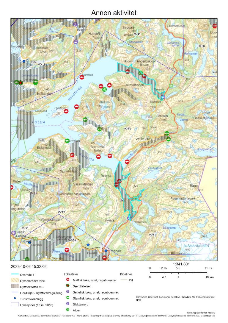
11.5 - Samlet vurdering av menneskelig aktivitet
11.5.1 - Oppsummering av aktivitet
11.5.1.1 - Gytefeltet
Det foregår et lite garnfiske på gytefeltet i gytetiden. Det er mulig at noe av fisket er rettet mot sei, siden seifangstene er forholdsvis store i lokasjonen (Tabell 15). På lokasjonsnivå er det fartøy < 11 m som dominerer torskefangstene, mens fartøy 11-14,99 m står for i underkant av 20 % av det totale uttaket av torsk. Gytefeltet er rangert på plass 12/22 i forhold til andelen fangst på gytefeltet og på plass 15/22 i forhold til kvantum fanget på gytefeltet, men disse anslagene er svært usikre da en stor del av sluttseddelfangsten ikke kunne kobles til sporingsdata (Vedlegg 1 og 2). Turist- og fritidsfisket kan også bidra til et større uttak på gytefeltene. Det er plassert oppdrettsanlegg for laksefisk i begge gytefeltene, men ingen turistfiskebedrifter.
11.5.1.2 - Lokasjonen – innenfor og utenfor fjordlinjen
Hele lokasjonen ligger innenfor fjordlinjen. Fiskeriaktiviteten i lokasjonen er relativt høy, også på flere av gytefeltene (Figur 47). Det ble totalt fanget 180 tonn torsk i lokasjonen i perioden 2018-2021, hvorav alt er anslått til å være kysttorsk og mesteparten ble fanget i gytetiden (Figur 49 , inkluderer ikke fangst fra fritids- og turistfiske). Oppdrettsaktiviteten er relativt høy i lokasjonen og overlapper med flere av gytefeltene.
11.5.2 - Konklusjon
Det mangler informasjon om biomassen av kysttorsk i området. Samlet sett vurderes den menneskelige aktiviteten til å være moderat i gyteområdene og i lokasjonen som helhet, med et ikke ubetydelig uttak av torsk. Det foregår trolig gyting i store deler av lokasjonen. Lokasjonen ligger helt sør i det nordlige bestandsområdet og har nok mer til felles med det sørlige bestandsområdet (62-67°N) som er vurdert til å være i dårligere forfatning enn den nordlige bestanden. Det tilrås fredning i gytetiden på minimum de utvalgte gytefeltene, for å redusere det totale uttaket av gytetorsk i området.
12 - Nordfjorden-Beiarkjeften, Bodø, Nordland
Posisjon: 67°10'54"N 14°19'06"E; lokref: 0-53
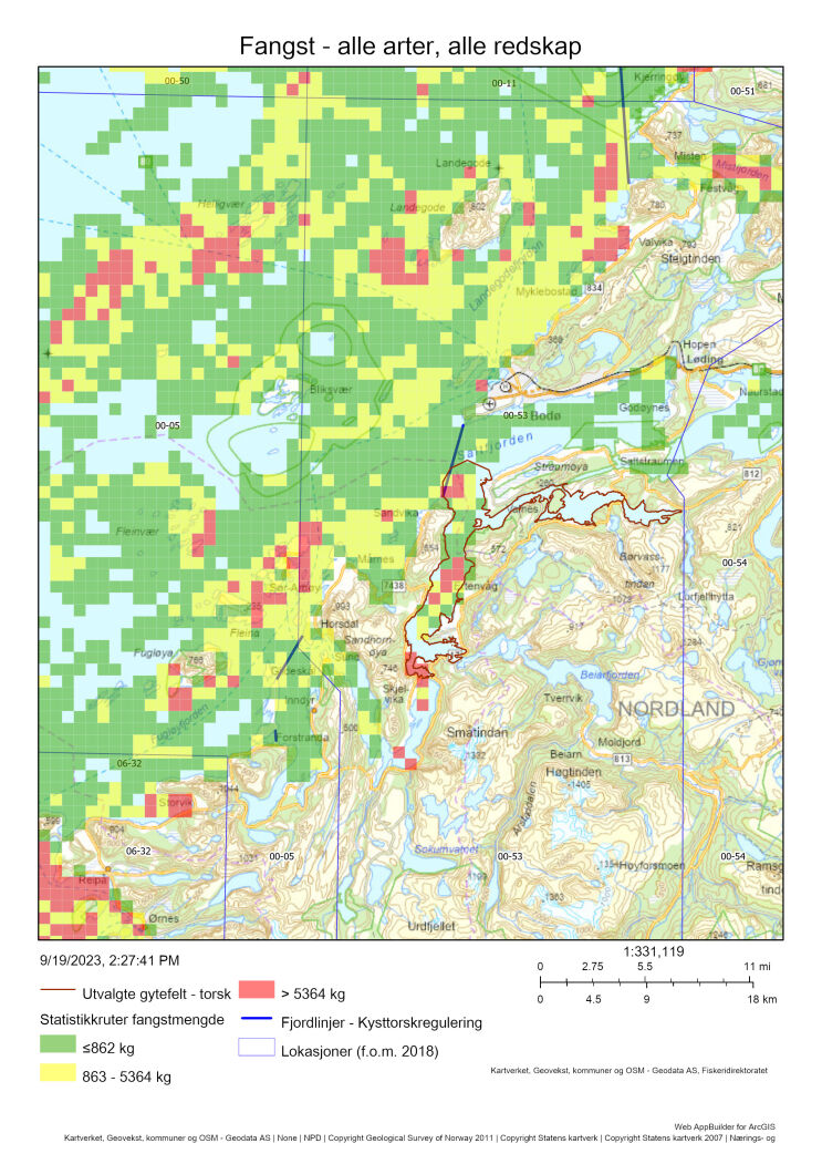
12.1 - Beskrivelse av området
Gytefeltet Nordfjorden-Beiarkjeften er klassifisert som nasjonalt viktig grunnet høy eggtetthet og god retensjon (A6). Den sørligste delen av området har også blitt identifisert som gytefelt i Fiskeridirektoratets intervjuundersøkelser. Innenfor lokasjonen har Havforskningsinstituttet identifisert to andre gytefelt, et lokalt (Breivik) og et regionalt viktig (Mistfjorden, se Figur 54). I ytre deler av lokasjonen er det identifisert flere mindre gyteområder i intervjuundersøkelsene.
Lokasjonen har store områder med skjellsand i ytre strøk, og noen områder med større tareskogforekomster og bløtbunnsområder i strandsonen. Alle disse naturtypene er klassifisert som svært viktige. Skjellsands- og bløtbunnsområder forekommer også i noen grad innenfor det utvalgte gytefeltet. Beiarfjorden som munner ut i Nordfjorden har status som Nasjonal laksefjord.
Det ble gjort DNA-analyser på egg samlet inn nord for Bodø under gytefeltskartleggingen i 2011-2012, med hensikt på å indentifisere andelen kysttorsk/skrei. Kysttorsk-egg dominerte i prøvene (Figur 52). Det foreligger konserverte eggprøver fra flere år som kan analyseres på samme måte.
Det er ikke kjent om kysttorsken som gyter i området er stasjonær eller migrerende
12.2 - Kommersiell fiskeriaktivitet
I lokasjon 0-53, der de aktuelle gytefeltene inngår, tas de største mengdene torsk med garn av fartøy < 11 m rett før og i gytetiden (februar-april, Figur 53). Omtrent en fjerdedel av torskefangsten i februar tas med snurrevad, og det tas også mindre mengder med line og juksa gjennom mesteparten av året. Det mangler otolittprøvetaking i januar-mars, men prøver fra april og mai tilsier rundt 95 % kysttorsk. Denne andelen øker til 100 % i prøvene tatt fra juli og ut året (Tabell 22). Basert på DNA-analysene av egg kan andelen kysttorsk antas å være noe lavere i januar-mars, men kysttorsk dominerer allikevel i området (Figur 52). Den samlete fiskeriaktiviteten som kunne kobles til sporingsdata er lokalisert til de vestlige delene av gytefeltet (Figur 51), men det er mulig att denne oversiktsfiguren i større grad reflekterer variasjon i seifangster som er relativt høye i lokasjonen (Tabell 23). Anslagsvis 1 % av torskefangstene ble tatt inne på gytefeltet, men dette estimatet har stor usikkerhet grunnet en høy andel landinger som ikke kunne kobles til sporingsdata (Tabell 23)
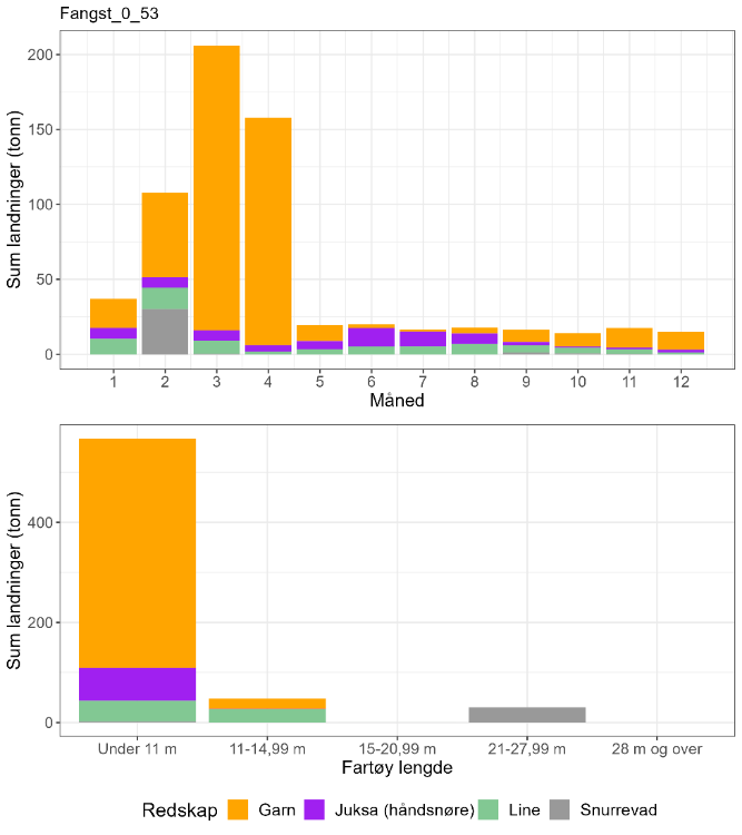
| Måned | Antall kysttorsk i prøve-materiale | Antall skrei i prøve-materiale | Totalt | Andel kysttorsk | Sum sluttseddelvekt (kg) torsk 2018-2022 | Herav kysttorsk (kg) |
| 1 | 0 | 0 | 0 | Ingen data | 37051 | Ingen data |
| 2 | 0 | 0 | 0 | Ingen data | 107662 | Ingen data |
| 3 | 0 | 0 | 0 | Ingen data | 205942 | Ingen data |
| 4 | 114 | 5 | 119 | 0,96 | 157908 | 151273 |
| 5 | 18 | 1 | 19 | 0,95 | 19599 | 18567 |
| 6 | 0 | 0 | 0 | Ingen data | 19908 | Ingen data |
| 7 | 5 | 0 | 5 | 1 | 16449 | 16449 |
| 8 | 79 | 0 | 79 | 1 | 17868 | 17868 |
| 9 | 63 | 0 | 63 | 1 | 16399 | 16399 |
| 10 | 11 | 0 | 11 | 1 | 13950 | 13950 |
| 11 | 34 | 0 | 34 | 1 | 17533 | 17533 |
| 12 | 10 | 0 | 10 | 1 | 14947 | 14947 |
| Fangst torsk gyte-område | Fangst sei gyte-område | Fangst hyse gyte-område | Fangst torsk lokasjon | Fangst sei lokasjon | Fangst hyse lokasjon | Prosent fangst i gyte-område torsk | Prosent fangst i gyte-område sei | Prosent fangst i gyte-område hyse | Prosent fangst i sluttseddel uten sporing (alle arter) |
| 3 | 118 | 4 | 536 | 1447 | 258 | 1 | 8 | 2 | 45 |
12.3 - Rekreasjonsfiske
Data på innsats og uttak i rekreasjonsfiske mangler for området.
Det er registrert 12 turistfiskebedrifter i lokasjonen, hvorav to er lokalisert innenfor det utvalgte gytefeltet (Figur 54).
12.4 - Annen menneskelig aktivitet i området
Lokasjonen har 13 oppdrettsanlegg for laks/regnbueørret/ørret i sjø (Figur 54), med en samlet kapasitet på 36 050 t. Det er også et anlegg for torskeoppdrett ved Landegode nord i lokasjonen, med klarert kapasitet på 1560 tonn (og ett lengre ut på kysten i lokasjon 00-05). Fem av anleggende for laks/regnbueørret/ørret ligger innenfor selve gytefeltet (samlet kapasitet 14 470). Lokasjonen har også tre anlegg for opprett av lavtrofiske arter, hovedsakelig tare (Figur 54).
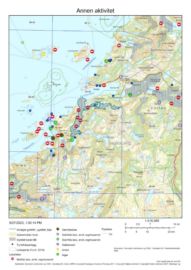
12.5 - Samlet vurdering av menneskelig aktivitet
12.5.1 - Oppsummering av aktivitet
12.5.1.1 - Gytefeltet
Det er fiskeriaktivitet på gytefeltet, men det er usikkert hvor mye torsk som tas her i gytetiden. Det er mulig at noe av fisket er rettet mot sei, siden seifangstene er forholdsvis store i lokasjonen (Tabell 23). På lokasjonsnivå er det fartøy < 11 m som dominerer torskefangstene og de fisker hovedsakelig med garn, men også noe med juksa og line. Gytefeltet er rangert på plass 16/22 i forhold til andelen fangst på gytefeltet og på plass 16/22 i forhold til kvantum fanget på gytefeltet, men disse anslagene er svært usikre da en stor del av sluttseddelfangsten ikke kunne kobles til sporingsdata (Vedlegg 1 og 2). Turist- og fritidsfisket kan også bidra til et større uttak på gytefeltene. Det er plassert flere oppdrettsanlegg for laksefisk i begge gytefeltene, og to turistfiskebedrifter.
12.5.1.2 - Lokasjonen – innenfor og utenfor fjordlinjen
Mesteparten av lokasjonen ligger utenfor fjordlinjen, men gytefeltet ligger innenfor fjordlinjen. Fiskeriaktiviteten er størst i sørlige og nordlige deler av lokasjonen (Figur 51). Det ble totalt fanget 536 tonn torsk i lokasjonen i perioden 2018-2021, der andelen kysttorsk er svært høy fra april og utover, mens data mangler i første kvartal. Mesteparten av torsken ble fanget i gytetiden ( Tabell 22 , inkluderer ikke fangst fra fritids- og turistfiske). Oppdrettsaktiviteten er relativt høy i lokasjonen.
12.5.2 - Konklusjon
Det mangler informasjon om biomassen av kysttorsk i området. Samlet sett vurderes den menneskelige aktiviteten til å være moderat i gyteområdet og i lokasjonen som helhet, med et ikke ubetydelig uttak av torsk. Lokasjonen ligger helt sør i det nordlige bestandsområdet og har nok mer til felles med det sørlige bestandsområdet (62-67°N) som er vurdert til å være i dårligere forfatning enn den nordlige bestanden. Det tilrås fredning i gytetiden på minimum det utvalgte gytefeltet, for å redusere uttaket av gytetorsk i området.
13 - Bjærangsfjorden, Meløy, Nordland
Posisjon: 66°44'54"N 13°27'00"E; lokref: 6-32
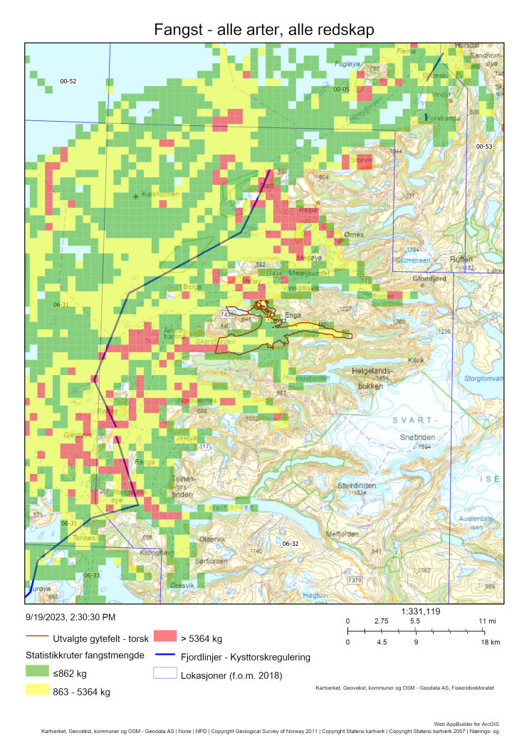
13.1 - Beskrivelse av området
Gytefeltet Bjærangsfjorden har blitt klassifisert som nasjonalt viktig (A6) grunnet stor mengde egg og stor tilbakeholdelse av egg. Det er overlapp mellom Havforskningsinstituttet sin kartlegging og Fiskeridirektoratets intervjuundersøkelser. Det er identifisert seks andre gyteområder i lokasjonen, der de fleste er regional viktige og helt eller delvis også er identifisert av fiskere. Lengre ut på kysten, delvis innenfor lokasjonen, ligger et kjent gyteområde for skrei. Det er usikkert hvor regelmessig dette området benyttes, men prøvetaking fra fiskeriene indikerer at det er en del skrei i lokasjonen i gytetiden (Tabell 24).
I lokasjonen er det store områder med skjellsand og tare, som er klassifisert som svært viktige naturtyper. De fleste slike områder ligger utenfor det aktuelle gyteområdet, men det er noe skjellsand i nordre del av gyteområdet.
Det er ikke gjort DNA-analyser på egg fra dette området, men det foreligger konserverte eggprøver som kan analyseres med hensikt på å indentifisere andelen kysttorsk/skrei. Det er sannsynlig at kysttorsk dominerer innenskjærs i lokasjonen, siden dette er et generelt mønster som blir sterkere fra nord til sør.
Det er ikke kjent om kysttorsken som gyter i området er stasjonær eller migrerende.
13.2 - Kommersiell fiskeriaktivitet
I lokasjon 6-32, der det aktuelle gytefeltet inngår, tas de største mengdene torsk med garn av fartøy < 11 m i gytetiden (mars-april, Figur 56), mens det er forholdsvis lave fangster resten av året. Det tas også en del torsk med garn fra fartøy 11-14,99 m (Figur 56). Fiskeaktiviteten (samlet for alle arter) er spredt utover lokasjonen, med størst aktivitet i gyteområdet Reipå (regional viktig) i nord samt i ytre deler av lokasjonen (Figur 55). Det er også fiskeaktivitet rundt gyteområdet for skrei nordvest i lokasjonen, men den mest konsentrerte aktiviteten foregår innenfor fjordlinjene.
I perioden 2018-2022 var anslagsvis 70 % av torskefangstene i mars kysttorsk, for å deretter øke til 88 % i april (Tabell 24). Gitt nærheten mellom det ytre gytefeltet for kysttorsk og gytefeltet for skrei er det trolig et blandet fiske nordvest i lokasjonen i gytetiden. På det utvalgte gytefeltet er det forholdsvis lav aktivitet, men unntak av de vestligste delene i ytre del av Skarsfjorden (Figur 55). Fangsten av torsk innenfor gytefeltet er estimert til 6 tonn, noe som utgjør 2 % av torskefangsten i lokasjonen. Dette anslaget har stor usikkerhet og er sannsynligvis et underestimat da over 50 % av sluttsedelfangsten i lokasjonen ikke lar seg koble mot sporingsdata (Tabell 25).
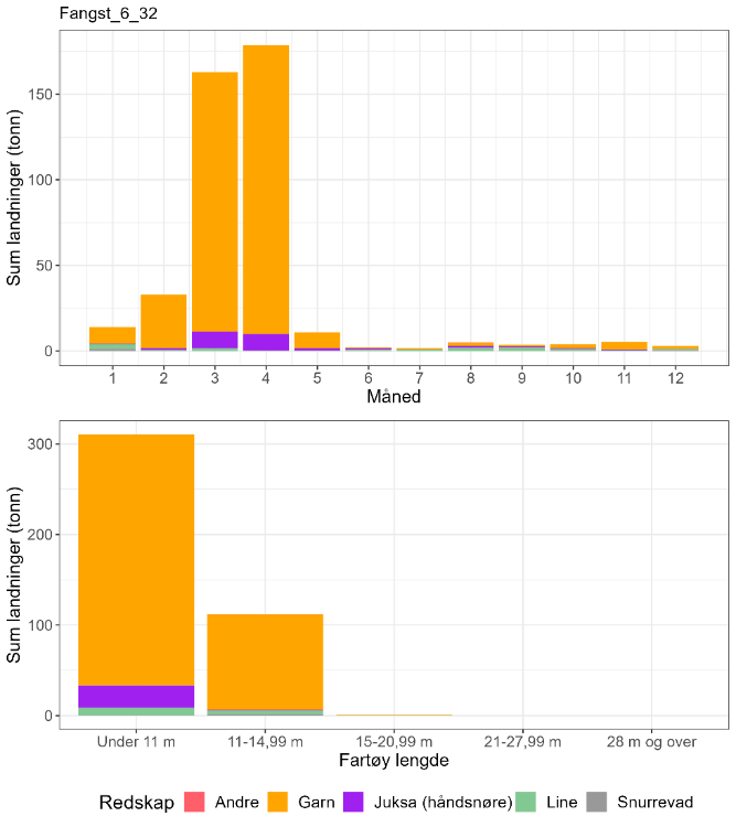
| Måned | Antall kysttorsk i prøve-materiale | Antall skrei i prøve-materiale | Totalt | Andel kysttorsk | Sum sluttseddelvekt (kg) torsk 2018-2022 | Herav kysttorsk (kg) |
| 1 | 36 | 5 | 41 | 0,88 | 13964 | 12261 |
| 2 | 0 | 0 | 0 | Ingen data | 32728 | Ingen data |
| 3 | 104 | 46 | 150 | 0,69 | 162970 | 112992 |
| 4 | 210 | 30 | 240 | 0,88 | 178704 | 156366 |
| 5 | 0 | 0 | 0 | Ingen data | 10706 | Ingen data |
| 6 | 0 | 0 | 0 | Ingen data | 2005 | Ingen data |
| 7 | 0 | 0 | 0 | Ingen data | 1692 | Ingen data |
| 8 | 121 | 6 | 127 | 0,95 | 4956 | 4722 |
| 9 | 98 | 0 | 98 | 1 | 3591 | 3591 |
| 10 | 96 | 9 | 105 | 0,91 | 3875 | 3543 |
| 11 | 86 | 13 | 99 | 0,87 | 5227 | 4541 |
| 12 | 27 | 8 | 35 | 0,77 | 2906 | 2242 |
| Fangst torsk gyte-område | Fangst sei gyte-område | Fangst hyse gyte-område | Fangst torsk lokasjon | Fangst sei lokasjon | Fangst hyse lokasjon | Prosent fangst i gyte-område torsk | Prosent fangst i gyte-område sei | Prosent fangst i gyte-område hyse | Prosent fangst i sluttseddel uten sporing (alle arter) |
| 6 | 46 | 5 | 341 | 311 | 75 | 2 | 15 | 6 | 56 |
13.3 - Rekreasjonsfiske
Data på innsats og uttak i rekreasjonsfiske mangler for området.
Det er registrert 11 turistfiskebedrifter i området, hvorav fem ligger innenfor eller i tilknytning til det utvalgte gytefeltet (Figur 57).
13.4 - Annen menneskelig aktivitet i området
Lokasjonen har 18 oppdrettsanlegg for laks/regnbueørret/ørret, ett for torsk, og to for tare (Figur 57). Anleggene for laksefisk har en samlet kapasitet på 72 891 tonn. Oppdrettsanlegget for torsk ligger på utsiden av Åmnøya, i nærheten av det utvalgte gyteområdet, og har en kapasitet på 3 600 t
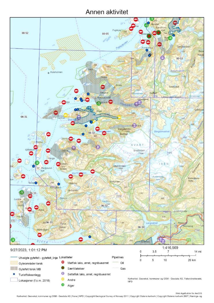
13.5 - Samlet vurdering av menneskelig aktivitet
13.5.1 - Oppsummering av aktivitet
13.5.1.1 - Gytefeltet
Det foregår et lite garnfiske på gytefeltet i gytetiden. Det er mulig at noe av fisket er rettet mot sei, siden 15 % av seifangstene i lokasjonen tas på det utvalgte gytefeltet (Tabell 25). På lokasjonsnivå er det fartøy < 11 m som dominerer, mens fartøy 11-14,99 m står for omtrent 25 % av det totale uttaket av torsk. Gytefeltet er rangert på plass 13/22 i forhold til andelen fangst av total torskefangst i lokasjonen som tas innenfor det utvalgte gytefeltet, og plass 14/22 i forhold til kvantum fanget på gytefeltet (Vedlegg 1 og 2). Det anslåtte uttaket på 6 tonn i perioden 2018-2021 utgjør bare 2 % av det totale uttaket av torsk i lokasjonen. Det bør allikevel tas høyde for stor usikkerhet i anslaget og for at det reelle uttaket er større siden turist- og fritidsfisket ikke er med i beregningene. Det er plassert et oppdrettsanlegg for torsk mellom det utvalgte gytefeltet og det ytre, lokalt viktige gytefeltet Storøyflaket, noe som kan være en trussel for vill torsk ved f.eks. gyting i merd. Det er i tillegg flere oppdrettsanlegg for laksefisk rundt gytefeltet.
13.5.1.2 - Lokasjonen – innenfor og utenfor fjordlinjen
Mesteparten av gytefeltene i lokasjonen ligger innenfor fjordlinjen. Fiskeriaktiviteten som kunne spores i lokasjonen er mest intensiv rundt det nordlige gyteområdet Reipå samt sørvest i lokasjonen, blant annet rundt gyteområdet Storøyflaket (Figur 55 og Figur 57). Det ble totalt fanget omtrent 420 tonn torsk i lokasjonen i perioden 2018-2022, hvorav minst 70 % er anslått til å være kysttorsk og mesteparten ble fanget i gytetiden (Tabell 24 , inkluderer ikke fangst fra fritids- og turistfiske). Dette gir en rangering på plass 82 av 563 i kysttorskuttak blant lokasjoner på kysten det det fiskes torsk (Vedlegg 2). Oppdrettsanlegg for laksefisk overlapper med gytefeltene Reipå og Storøyflaket, men ikke med det utvalgte gytefeltet i Bjærangsfjorden.
13.5.2 - Konklusjon
Det mangler informasjon om biomassen av kysttorsk i området, men sett opp mot den forholdsvis store torskefangsten er det grunn til å forvente at fiskepresset i lokasjonen er – i hvert fall lokalt – høy. Samlet sett vurderes den menneskelige aktiviteten til å være moderat i selve gyteområdet, men høy på og kring andre gytefelt i lokasjonen. Lokasjonen tilhører det sørlige bestandsområdet (62-67°N) som er vurdert til å være i dårligere forfatning enn den nordlige bestanden. Det tilrås å vurdere utvidet fredning i gytetiden (f.eks. innenfor fjordlinjen) for å redusere det totale uttaket av gytetorsk i lokasjonen.
14 - Grytøya-Vikafjorden, Vandve-Dønna, Nordland
Posisjon: 66°6,52′ 12°17,72’ 66°10.5’N, 12°25.0’E; lokref: 6-33
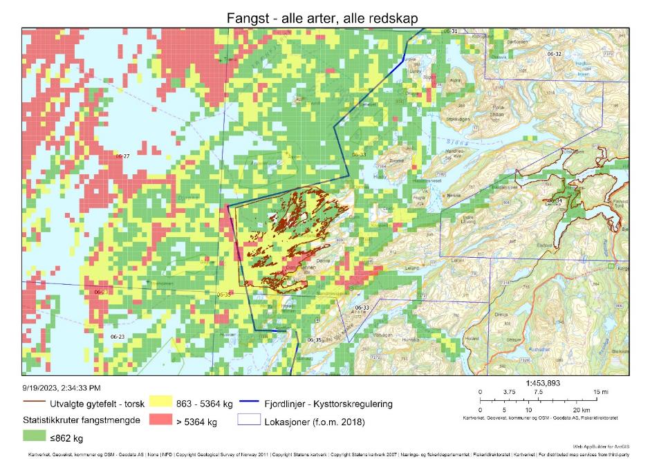
14.1 - Beskrivelse av området
Grytøya-Vikafjorden på vestsida av Dønna er klassifisert som regionalt viktig gytefelt (B5) grunnet høy eggtetthet og middels tilbakeholdelse (retensjon) av eggene, og området ble identifisert som gytefelt både i Havforskningsinstituttet sine egg undersøkelser (2012) og i Fiskeridirektoratets intervjuundersøkelser med fiskere (Figur 58). Det samme ble gytefeltet Skipsfjorden-Ulvangen på østsiden av Dønna, men her ble det registrert noe mindre egg i 2012 (C4). Siden begge disse gytefeltene ligger nær hverandre i samme lokasjon, så vurderer vi disse gytefeltene samlet (bortsett fra Tabell 27 hvor det bare refereres til Grytøya-Vikafjorden gytefeltet).
Området Vandve-Dønna inngår i Havforskningsinstituttets regelmessige garn-ruse tokt mellom Stad-Steigen i august måned for å kartlegge og estimere årsklassestyrke av kysttorsk på tidlige stadier som 1-3 åringer. Det samme gjør området Solvær nord for Dønna i samme lokasjon, og Solvær har i mange år vært det området på kyststrekningen Stad-Steigen med mest småtorsk. Det kan derfor godt tenkes at dette påvirkes av gytingen i gytefeltene ved Dønna som dermed tilsier at disse feltene er blant de viktigste på Helgelandskysten.
14.2 - Kommersiell fiskeriaktivitet
Mesteparten av torskefangstene i lokasjonen blir tatt med garn fra båter < 11 m rett før og i gytetiden (februar-april, Figur 59). Det tas også en del torsk med juksa i samme periode og utover sommeren (Figur 59).
Basert på Figur 59 så skjer mye av fiskeriaktiviteten på gytetorsk i lokasjonen, men det understrekes at en svært høy andel av fangsten ikke kunne kobles mot sporingsdata og at det geografiske fiskemønsteret derfor er usikkert (Tabell 27). I perioden 2018-2021 kunne en total fangst av torsk på 125 tonn kobles til det utvalgte gytefeltet på vestsiden av Dønna (Tabell 27). Det meste av fiskeaktiviteten foregår i og omkring sørvestre del av dette gytefeltet, men også i området Ulvangen-Meisfjorden på østsiden av Dønna mot Sandnessjøen.
Prøver fra fiskeriene foreligger både fra februar-april, august og oktober, og materialet består nesten utelukkende av kysttorsk (Tabell 26).
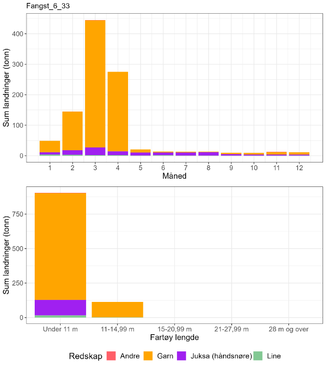
| Måned | Antall kysttorsk i prøve-materiale | Antall skrei i prøve-materiale | Totalt | Andel kysttorsk | Sum sluttseddelvekt (kg) torsk 2018-2022 | Herav kysttorsk (kg) |
| 1 | 47 | 1 | 48 | 0,98 | 49287 | 48261 |
| 2 | 112 | 2 | 114 | 0,98 | 144932 | 142390 |
| 3 | 258 | 48 | 306 | 0,84 | 444987 | 375185 |
| 4 | 188 | 7 | 195 | 0,96 | 275125 | 265248 |
| 5 | 61 | 0 | 61 | 1 | 20625 | 20625 |
| 6 | 31 | 0 | 31 | 1 | 13574 | 13574 |
| 7 | 0 | 0 | 0 | Ingen data | 13020 | Ingen data |
| 8 | 289 | 0 | 289 | 1 | 13241 | 13241 |
| 9 | 40 | 0 | 40 | 1 | 9239 | 9239 |
| 10 | 219 | 0 | 219 | 1 | 9162 | 9162 |
| 11 | 30 | 0 | 30 | 1 | 12437 | 12437 |
| 12 | 55 | 0 | 55 | 1 | 11366 | 11366 |
| Fangst torsk gyte-område | Fangst sei gyte-område | Fangst hyse gyte-område | Fangst torsk lokasjon | Fangst sei lokasjon | Fangst hyse lokasjon | Prosent fangst i gyte-område torsk | Prosent fangst i gyte-område sei | Prosent fangst i gyte-område hyse | Prosent fangst i sluttseddel uten sporing (alle arter) |
| 125 | 195 | 25 | 884 | 1601 | 135 | 14 | 12 | 19 | 46 |
14.3 - Rekreasjonsfiske
Data på innsats og uttak i rekreasjonsfiske mangler for området. I forbindelse med bestandsberegninger av kysttorsk mellom 62-67N er rekreasjonsfisket av kysttorsk antatt å være minst like stort som det kommersielle fisket, det vil si over 4 000 tonn (ICES, 2023b).
Det er registrert 17 turistfiskebedrifter i lokasjonen, hvorav ni ligger i tilknytting til gytefeltene kring Dønna (Figur 60).
14.4 - Annen menneskelig aktivitet i området
Lokasjonen har 33 oppdrettsanlegg for laks/regnbueørret/ørret, hvorav 2 landbaserte og 2 for forskning og undervisning, 2 for torsk, og 2 for tare (Figur 60). Det er også registrert 7 sjøanlegg for blåskjell i Leirfjorden, i ytterkant av det østligste gytefeltet. Anleggene for laksefisk har en samlet kapasitet på ca 125 000 tonn. 11 av oppdrettsanleggene for laks/regnbueørret/ørret ligger inne i gytefeltene kring Dønna. Oppdrettsanleggene for torsk ligger ved øya Hugla, i nærheten av det utvalgte gyteområdet, og har en kapasitet på til sammen 7 200 t (nesten like mye som det totalt ble fisket av vill kysttorsk langs hele kysten mellom 62-67N, d.e. 7 735 tonn i 2021).
Byen Sandnessjøen med ca. 6 000 innbyggere (2023) grenser opp til gytefeltet i Ulvangen-Meisfjorden på østsiden av Dønna.
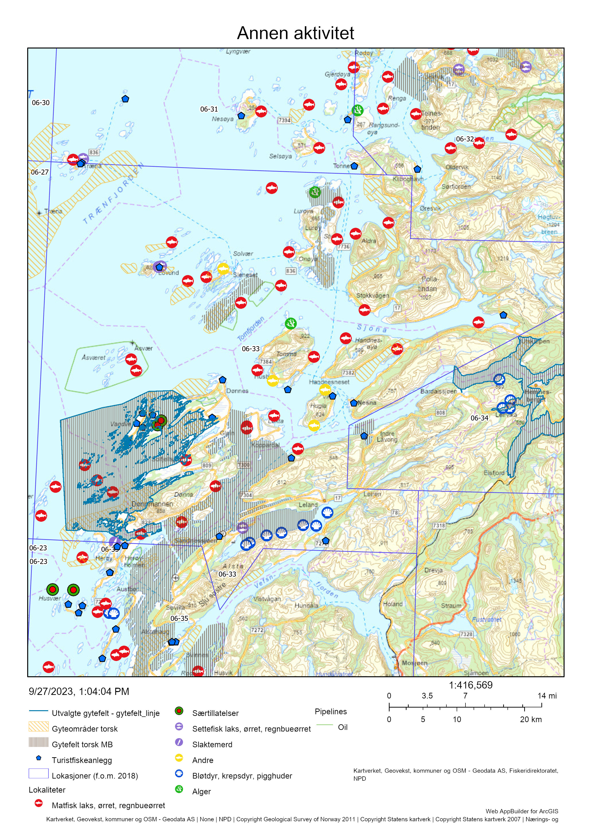
14.5 - Samlet vurdering av menneskelig aktivitet
14.5.1 - Oppsummering av aktivitet
14.5.1.1 - Gytefeltet
Det foregår et garnfiske på gytefeltet Grytøya-Vikafjorden i gytetiden, men bare 14% av de sporbare torskefangstene i lokasjon tas her (Tabell 27). Merk at hele 46% av torskefangstene er tatt av fartøy uten sporing. På lokasjonsnivå er det fartøy < 11 m som dominerer, mens fartøy 11-14,99 m står for omtrent 12 % av det totale uttaket av torsk. Gytefeltet er rangert på plass 4/22 i forhold til andelen fangst av total torskefangst i lokasjonen som tas innenfor det utvalgte gytefeltet, og plass 4/22 i forhold til kvantum fanget på gytefeltet (Vedlegg 1 og 2).
Det anslåtte uttaket på 125 tonn på gytefeltet Grytøya-Vikafjorden i perioden 2018-2021 utgjør 14 % av det totale uttaket av torsk i lokasjonen. Det bør allikevel tas høyde for stor usikkerhet i anslaget og for at det reelle uttaket er større siden turist- og fritidsfisket ikke er med i beregningene. Oppdrettsanleggene for torsk ligger ved øya Hugla, i nærheten av det utvalgte gyteområdet, og har en kapasitet på til sammen 7 200 t (nesten like mye som det totalt ble fisket av vill kysttorsk langs hele kysten mellom 62-67N, d.e. 7 735 tonn i 2021). Siden disse anleggene ligger på nordsiden av gyteområdene så vil mest sannsynlig egg fra ev. gyting i torskemerdene bli fraktet med strøm nordover og dermed være en mindre trussel for den ville torskens gyting på gytefeltene fokusert på i dette avsnitt. Evt. egg og larver fra gyting i torskemerdene vil imidlertid lett kunne transporteres og vandre til de rike oppvekstområdene lengre nord.
Det er i tillegg flere oppdrettsanlegg for laksefisk rundt gytefeltet.
14.5.1.2 - Lokasjonen – innenfor og utenfor fjordlinjen
Mesteparten av gytefeltene til kysttorsk i lokasjonen ligger innenfor fjordlinjen, bortsett fra gytefeltene ved Lovund og Træna. Fiskeriaktiviteten som kunne spores i lokasjonen er mest intensiv i sørvestre del av gytefeltet Grytøya-Vikafjorden samt i området Ulvangen-Meisfjorden i gytefeltet øst for Dønna, samt Lurøya i nordlig del av lokasjonen og særlig Træna som grenser opp til lokasjonen i nordvestre del. Her kan merkes at Havforskningsinstituttet ennå ikke har kartlagt gytefeltene ved Lovund og Træna (Figur 60).
Det ble totalt fanget omtrent 1 000 tonn torsk i lokasjonen i perioden 2018-2021, hvorav over 90 % anslått til å være kysttorsk i de fire første månedene, og deretter bare kysttorsk (Tabell 26, inkluderer ikke fangst fra fritids- og turistfiske). Dette rangerer lokasjonen på plass 52 av 563 blant lokasjoner på kysten der det fiskes kysttorsk (Vedlegg 2). Oppdrettsanlegg for laksefisk overlapper med begge de omtalte gytefeltene kring Dønna, og dessuten på/ved gytefeltene i Solvær, Lurøya og Lovund. Oppdrettsanleggene for torsk ligger utenfor gytefeltene for villtorsk.
14.5.2 - Konklusjon
Det mangler informasjon om biomassen av kysttorsk i området, men sett opp mot den forholdsvis store torskefangsten er det grunn til å forvente at fiskepresset i lokasjonen er – i hvert fall lokalt – høy. Samlet sett vurderes den menneskelige aktiviteten til å være høy i gyteområdene kring Dønna inkl. Meisfjorden, og også relativt høy på gytefeltet ved Lurøya. Lokasjon 6-33 tilhører det sørlige bestandsområdet (62-67°N) som er vurdert til å være i dårligere forfatning enn den nordlige bestanden. Det tilrås å vurdere utvidet fredning i gytetiden (f.eks. innenfor fjordlinjen) for å redusere det totale uttaket av gytetorsk i lokasjonen.
Risikoen knyttet til torskeoppdrett er i stor grad avhengig av mengde fisk i sjø og plassering av anleggene. Med såpass store kvantumstillatelser til å drive torskeoppdrett så tilrås det merking av oppdrettstorsken slik at evt. rømming eller gyting i merd kan spores.
I Risikorapport norsk fiskeoppdrett 2022 vurderes risikoen for negative effekter av torskeoppdrett på ville kysttorskbestander å være høy i området mellom 62°N og 67°N, med en samlet omsøkt produksjonsintensitet på 130 000 tonn oppdrettstorsk (Grefsrud et al. 2022a).
I nevnte Risikorapport står det videre at «basert på tidligere erfaringer vet vi at oppdrettstorsken er mer rømmingsvillig enn laksen og at den kan bli kjønnsmoden og gyte i merd før den er slakteklar. Torskenæringen mener de har løst disse problemene gjennom avl, men det finnes ingen vitenskapelig dokumentasjon for påstandene. Inntil denne dokumentasjonen foreligger må man anta at torskeoppdrett fortsatt vil ha utfordringer og tempoet i den forespeilede oppskaleringen bør reduseres for å få tid til å ta gode beslutninger, spesielt i forhold til lokalisering av de nye anleggene. Vi mangler også kunnskap om hvordan torskeoppdrett kan bidra til økt belastning i områder med etablert lakseoppdrett og et av spørsmålene i tiden fremover vil være om torskeoppdrett skal komme i tillegg til den eksisterende oppdrettsaktiviteten på laks og ørret eller om torsken i enkelte områder skal erstatte laks og ørret».
Det anbefales at forvaltningen og myndighetene i større grad stiller krav til bruk av lukkede anlegg ved fremtidig tildeling av konsesjoner for torskeoppdrett.
15 - Hemnes, Mo i Rana, Nordland
Posisjon: 66°15'10"N 13°45'50"E; lokref: 6-34
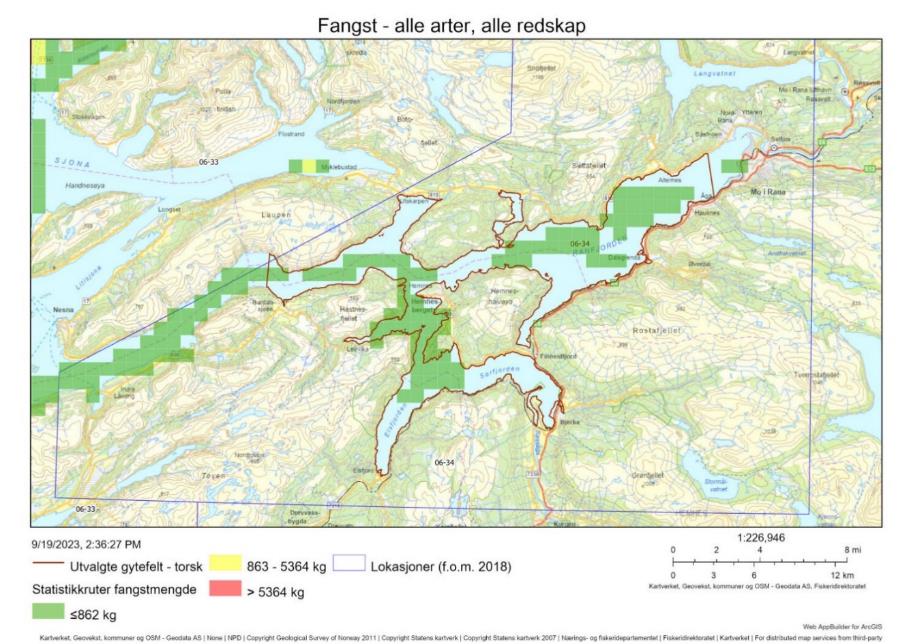
15.1 - Beskrivelse av området
Gyteområdet Hemnes i Ranfjorden er klassifisert som nasjonalt viktig (A6) grunnet høy eggtetthet og høy retensjon. Området har blitt identifisert som gytefelt i Havforskningsinstituttet sine eggundersøkelser. Deler av området har også blitt identifisert i Fiskeridirektoratets intervjuundersøkelser med fiskere. Lokasjonen har ytterligere et gytefelt lengre ut i fjorden, som er klassifisert som lokalt viktig. Rundt øya Dønna lengre ut på kysten (utenfor lokasjonen) ligger flere lokalt og regionalt viktige gytefelt. Det er gyteområde for skrei ute på kysten nord for Dønna og rundt Træna.
Innenfor gyteområdet finnes flere mindre områder med svært viktige naturtyper; bløtbunnsområde i strandsonen, sterke tidevannsstrømmer, og noe ålegress. Ranfjorden er en Nasjonal laksefjord.
Ranfjorden har i lang tid vært utsatt for store utslipp fra omfattende industrivirksomhet rundt Mo i Rana, blant annet olje fra oljeutskiller, og metaller, tungmetaller, PAH, PCB, PFAS, og cyanid fra vannrenseanlegg (NIVA, 2022). Over tid har utslippet av PAH, olje, fett og noen metaller fra industriparken til fjorden blitt redusert, men det er fortsatt frarådet å spise blåskjell fra indre deler av fjorden grunnet PAH-forurensning (Miljøstatus - Miljødirektoratet). Historisk har det vært stor gruvevirksomhet i området, med avrenning og/eller deponering av slagg i fjorden. Det foregår fortsatt deponering av suspendert stoff fra gruvevirksomhet til deponi i fjorden. I en undersøkelse av bunnfauna utført av NIVA i 2021 dominerte moderat eller dårlig tilstand de undersøkte områdene, og det ble notert en negativ utvikling over tid. Bunnen var påvirket av gruveavgang og sedimentasjon av andre avgangspartikler helt ut til 20 km fra industriparken. Gytefeltet Hemnes ligger 4-35 km fra industriparken, og ved eggundersøkelser har det blitt observert oransje slam nært overflaten i indre deler. For flere detaljer om utslipp til fjorden vises det til rapporten fra NIVA (2022).
Det foreligger konserverte eggprøver fra området som kan analyseres med hensikt på å indentifisere andelen kysttorsk/skrei. Resultater fra analyser lengre nord og sør indikerer en høy andel kysttorsk, og dette gytefeltets indre beliggenhet tilsier også at det er kysttorsk som gyter her. Det foreligger få prøver fra fiskeriene og ingen fra gytetiden, men prøver tatt i oktober i perioden 2018-2022 var utelukkende kysttorsk (Tabell 28).
Det er ikke kjent om kysttorsken som gyter i området er stasjonær eller migrerende, men overordnet er det større sannsynlighet for at det forekommer en lokal torskestamme i et indre område som dette enn i ytre kyststrøk.
15.2 - Kommersiell fiskeriaktivitet
Kommersielle fiskerier fanger forholdvis lite torsk i området. Det er et lite fiskeri med garn fra båter < 11 m i gytetiden, med topp i mars (Figur 62). Anslaget på kvantum torsk fanget i selve gyteområdet er svært lavt; 200 kg som utgjør 3 % av den totale torskefangsten i lokasjonen (Tabell 29). Dette anslaget har høy usikkerhet da to tredjedeler av fangsten fra fartøy < 15 m mangler sporingsdata og kunne derfor ikke inkluderes i anslaget på fangst innenfor gytefeltet. Basert på oversiktskartet og det faktum at gytefeltet dekker en stor del av lokasjonen er det sannsynlig at den reelle andelen er mye høyere (Figur 61).
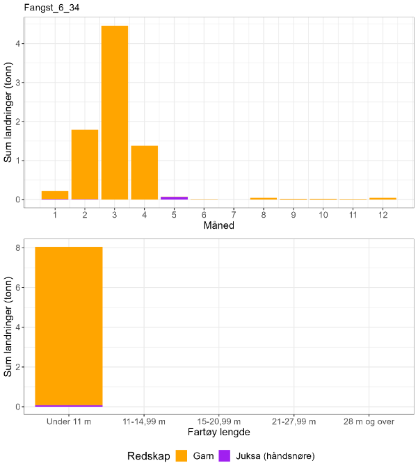
| Måned | Antall kysttorsk i prøve-materiale | Antall skrei i prøve-materiale | Totalt | Andel kysttorsk | Sum sluttseddelvekt (kg) torsk 2018-2022 | Herav kysttorsk (kg) |
| 1 | 0 | 0 | 0 | Ingen data | 218 | Ingen data |
| 2 | 0 | 0 | 0 | Ingen data | 1791 | Ingen data |
| 3 | 0 | 0 | 0 | Ingen data | 4462 | Ingen data |
| 4 | 0 | 0 | 0 | Ingen data | 1378 | Ingen data |
| 5 | 0 | 0 | 0 | Ingen data | 69 | Ingen data |
| 6 | 0 | 0 | 0 | Ingen data | 3 | Ingen data |
| 7 | 0 | 0 | 0 | Ingen data | 0 | Ingen data |
| 8 | 0 | 0 | 0 | Ingen data | 38 | Ingen data |
| 9 | 0 | 0 | 0 | Ingen data | 16 | Ingen data |
| 10 | 57 | 0 | 57 | 1 | 21 | 21 |
| 11 | 0 | 0 | 0 | Ingen data | 9 | Ingen data |
| 12 | 0 | 0 | 0 | Ingen data | 39 | Ingen data |
| Fangst torsk gyte-område | Fangst sei gyte-område | Fangst hyse gyte-område | Fangst torsk lokasjon | Fangst sei lokasjon | Fangst hyse lokasjon | Prosent fangst i gyte-område torsk | Prosent fangst i gyte-område sei | Prosent fangst i gyte-område hyse | Prosent fangst i sluttseddel uten sporing (alle arter) |
| 0.2 | 0.8 | 0.1 | 5.9 | 9.6 | 1.1 | 3 | 8 | 9 | 66 |
15.3 - Rekreasjonsfiske
Data på innsats og uttak i rekreasjonsfiske mangler for området.
Det er registrert en turistfiskebedrift i lokasjonen. Denne ligger ved det ytre gyteområdet (Figur 63).
15.4 - Annen menneskelig aktivitet i området
Det er fire akvakulturlokaliteter i sjø i området, tre for skipsrur og en for blåskjell (Figur 63).
Det slippes hvert år ut millioner tonn suspendert stoff og kjemikalierester fra gruvedrift til sjødeponi i fjorden, i tillegg til andre utslipp fra omfattende industrivirksomhet kring Mo i Rana (se «Beskrivelse av området»). Se videre kapitlet om Repparfjorden og Revsbotn for en diskusjon om effekter av suspendert gruveavfall på fiskeegg.
Flere av de kommunale renseanleggene har utslipp av spillvann til Ranfjorden.
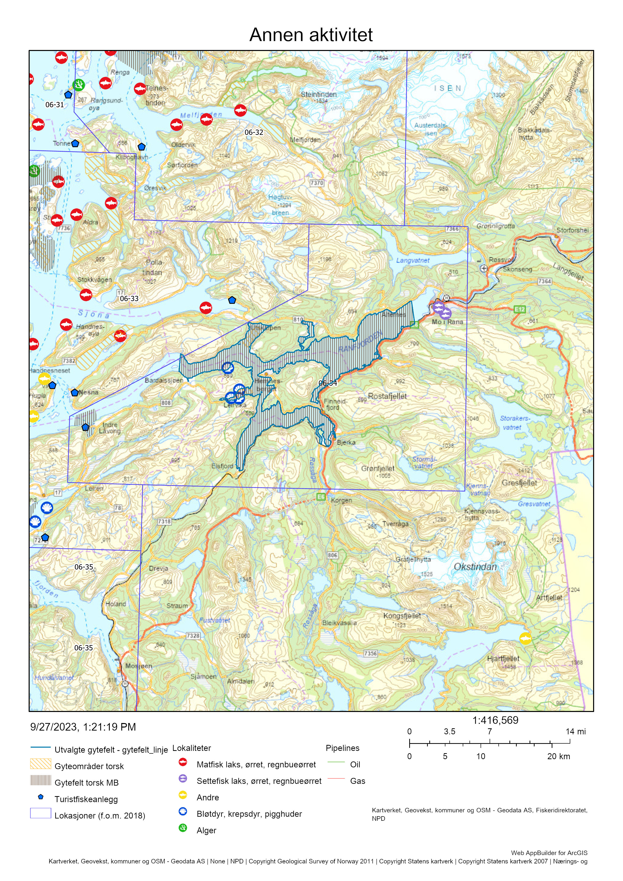
15.5 - Samlet vurdering av menneskelig aktivitet
15.5.1 - Oppsummering av aktivitet
15.5.1.1 - Gytefeltet
Torskefisket foregår nesten utelukkende i gytetiden i lokasjonen, og fangstene tas med garn fra fartøy < 11 m. Det fanges også små mengder sei og hyse. Gytefeltet er rangert på plass 9/22 i forhold til andelen fangst av total torskefangst i lokasjonen som tas innenfor det utvalgte gytefeltet (Vedlegg 1), men ville nok rangeres høyere hvis en større andel av fangsten kunne kobles til sporingsdata. Gytefeltet havner på plass 19/22 i forhold til kvantum fanget på gytefeltet, med et svært lavt kvantum på 0.2 tonn (Vedlegg 2). Turist- og fritidsfiske bidrar trolig lite til uttaket av torsk i området da det bare er en bedrift registrert i lokasjonen. Det er ingen oppdrettsanlegg i sjø i eller utenfor gyteområdet som forventes å utgjøre en trussel for vill torsk. Utslipp fra industri er trolig den største trusselen for torsken i området.
15.5.1.2 - Lokasjonen – innenfor og utenfor fjordlinjen
Hele lokasjonen med sine to gytefelt ligger innenfor fjordlinjen (Figur 61 og Figur 63). Fiskeriaktiviteten fremstår som jevnt fordelt i lokasjonen, men eventuell romlig variasjon i de lave fangstene vil ikke komme frem i Figur 61. Det ble totalt fanget omtrent 8 tonn torsk i lokasjonen i perioden 2018-2022. Det mangler prøvegrunnlag for å skille mellom kysttorsk og skrei i gytetiden, men fangsten er trolig ren kysttorsk basert på den geografiske lokasjonen og prøver fra oktober (Tabell 28, inkluderer ikke fangst fra fritids- og turistfiske).
15.5.2 - Konklusjon
Det mangler informasjon om biomassen av kysttorsk i området. Lokasjonen består av et enkelte fjordsystem, så den lave torskefangsten må ses i sammenheng med at lokasjonen er et relativt lite område sammenlignet med andre presentert i denne rapporten. Det virker allikevel usannsynlig at en fangst på 8 tonn over fem år vil ha en negativ innvirkning på torsken i området. Samlet sett vurderes den menneskelige aktiviteten allikevel til å være svært høy både i selve gyteområdet og generelt i lokasjonen med tanke på industrivirksomheten som historisk og i nåtid gir store utslipp til fjorden. Lokasjonen tilhører det sørlige bestandsområdet (62-67°N) som er vurdert til å være i dårligere forfatning enn den nordlige bestanden. Det tilrås derfor at torskefisket på gytefeltet bør holdes på et lavt nivå også fremover med tanke på den høye samlete belastningen fra menneskelig aktivitet i Ranfjorden.
16 - Storfjorden, Nordland
Posisjon: 65°33'42"N 12°33'24"E; lokref: 6-35
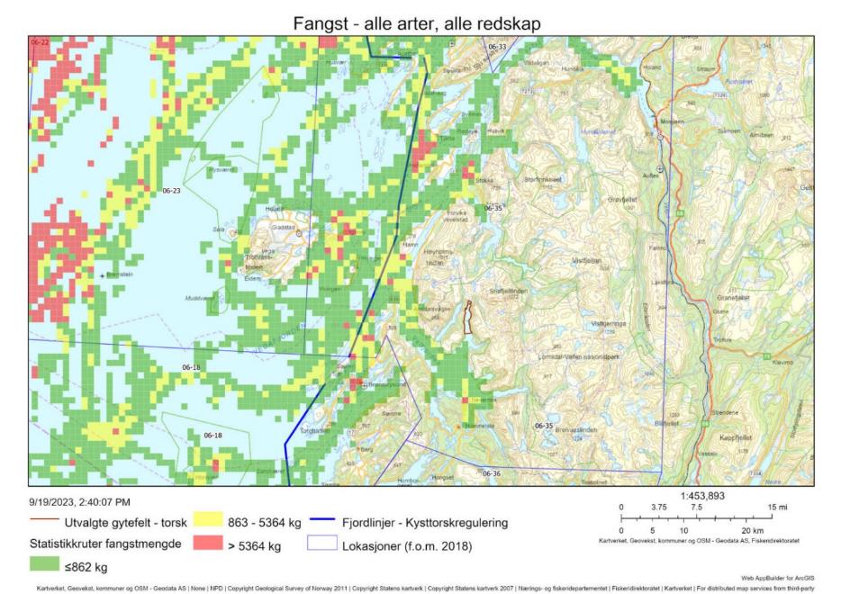
16.1 - Beskrivelse av området
Gytefeltet Storfjorden ligger i en arm til Velfjorden ved Brønnøysund og er klassifisert som nasjonalt viktig (A6) grunnet høy eggtetthet og god retensjon. Området har blitt identifisert som gytefelt både i Havforskningsinstituttet sine eggundersøkelser og i Fiskeridirektoratets intervjuer med fiskere. I Velfjorden finnes det flere andre lokalt og regional viktige gytefelt. Det er også flere lokalt og regionalt viktige gytefelt nord i lokasjonen i Mindværfjorden, Vefsnfjorden, Tjøttfjorden og Alstenfjorden, og ett gyteområde for skrei ved Vega lengre ut på kysten.
Nord i lokasjonen finnes flere områder med den viktige naturtypen bløtbunnsområde i strandsonen. Det er ikke registrert særlig verdifulle naturtyper i det utvalgte gyteområdet. Vefsnfjorden, nord i lokasjonen, er en Nasjonal laksefjord.
DNA-analyser på egg fra området viser en høy andel kysttorsk (Figur 65). Prøvene fra fiskerier i lokasjonen er nesten utelukkende fra kysttorsk (Tabell 30).
Det er ikke kjent om kysttorsken som gyter i området er stasjonær eller migrerende.
16.2 - Kommersiell fiskeriaktivitet
Mesteparten av torskefangstene i lokasjonen blir tatt med garn fra båter < 11 m rett før og i gytetiden (februar-april, Figur 66). Det tas også en del torsk med juksa i samme periode og utover sommeren, samt med line i sommermånedene. Et lite garnfiske foregår også på høsten (oktober-november, Figur 66).
Basert på Figur 64 så skjer mesteparten av fiskeriaktiviteten på gyteområder i lokasjonen, men det understrekes at en svært høy andel av fangsten ikke kunne kobles mot sporingsdata og at fiskemønsteret derfor er usikkert (Tabell 31). I perioden 2018-2021 kunne en total fangst av torsk på 300 kg kobles til det utvalgte gytefeltet (Tabell 31).
Prøver fra fiskeriene foreligger både fra mars-april, august og oktober, og materialet består nesten utelukkende av kysttorsk (Tabell 30).
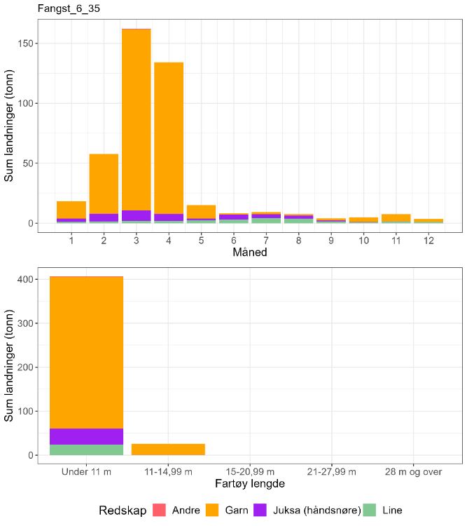
| Måned | Antall kysttorsk i prøve-materiale | Antall skrei i prøve-materiale | Totalt | Andel kysttorsk | Sum sluttseddelvekt (kg) torsk 2018-2022 | Herav kysttorsk (kg) |
| 1 | 0 | 0 | 0 | Ingen data | 18309 | Ingen data |
| 2 | 0 | 0 | 0 | Ingen data | 57767 | Ingen data |
| 3 | 22 | 0 | 22 | 1 | 162182 | 162182 |
| 4 | 14 | 1 | 15 | 0,93 | 134147 | 125203 |
| 5 | 0 | 0 | 0 | Ingen data | 15058 | Ingen data |
| 6 | 0 | 0 | 0 | Ingen data | 8168 | Ingen data |
| 7 | 0 | 0 | 0 | Ingen data | 9272 | Ingen data |
| 8 | 184 | 0 | 184 | 1 | 7649 | 7649 |
| 9 | 0 | 0 | 0 | Ingen data | 4082 | Ingen data |
| 10 | 145 | 1 | 146 | 0,99 | 4819 | 4786 |
| 11 | 0 | 0 | 0 | Ingen data | 7628 | Ingen data |
| 12 | 0 | 0 | 0 | Ingen data | 3485 | Ingen data |
| Fangst torsk gyte-område | Fangst sei gyte-område | Fangst hyse gyte-område | Fangst torsk lokasjon | Fangst sei lokasjon | Fangst hyse lokasjon | Prosent fangst i gyte-område torsk | Prosent fangst i gyte-område sei | Prosent fangst i gyte-område hyse | Prosent fangst i sluttseddel uten sporing (alle arter) |
| 0.3 | 0.2 | 0 | 378 | 519 | 97 | < 0.1 | < 0.1 | 0 | 74 |
16.3 - Rekreasjonsfiske
Data på innsats og uttak i rekreasjonsfiske mangler for området.
Det er registrert 21 turistfiskebedrifter i lokasjonen, hvorav tre ligger i tilknytting til andre gytefelt i Velfjorden (Figur 67).
16.4 - Annen menneskelig aktivitet i området
Det er 21 anlegg for oppdrett av laks/regnbueørret/ørret i lokasjonen med en samlet kapasitet på 74 700 tonn, hvorav ett anlegg på 5 460 tonn er plassert rett utenfor gyteområdet (Figur 67). Det er i tillegg 14 anlegg for lavtrofiske arter (blåskjell, rur og tare).

16.5 - Samlet vurdering av menneskelig aktivitet
16.5.1 - Oppsummering av aktivitet
16.5.1.1 - Gytefeltet
Torskefisket i lokasjonen foregår primært med garn og juksa i gytetiden i lokasjonen, men det er lite fangst registrert på det utvalgte gytefeltet. Det råder stor usikkerhet knyttet til vurderingen av fiskeaktivitet på gytefeltet da 74 % av fangsten i lokasjonen ikke kunne kobles til sporingsdata. Basert på fangsten som kunne spores havner gytefeltet på plass 19/22 i forhold til andelen fangst av total torskefangst i lokasjonen som tas innenfor det utvalgte gytefeltet (Vedlegg 1), og på plass 18/22 i forhold til kvantum fanget på gytefeltet (Vedlegg 2). Turist- og fritidsfiske kan også bidra til uttaket av torsk på gytefeltet, men er nok viktigere på andre steder i lokasjonen. Det er et oppdrettsanlegg for laksefisk rett utenfor gyteområdet (plassert i et annet gyteområde) som kan ha en negativ innvirkning på det lokale miljøet og påvirke torskens diett.
16.5.1.2 - Lokasjonen – innenfor og utenfor fjordlinjen
De fleste gytefeltene i lokasjonen ligger innenfor fjordlinjen (Figur 64 og Figur 67), men lokasjonen dekker også områder utenfor fjordlinjen, ut mot Vega. Fiskeriaktiviteten fremstår konsentrert kring gytefelt, men det er som tidligere nevnt en stor andel av aktiviteten som ikke vises i Figur 64. Det ble totalt fanget omkring 430 tonn torsk i lokasjonen i perioden 2018-2022, der mesteparten er anslått til å være kysttorsk (Tabell 30, inkluderer ikke fangst fra fritids- og turistfiske).
16.5.2 - Konklusjon
Det mangler informasjon om biomassen av kysttorsk i området. Lokasjonen består av både indre og ytre kystområder og kan potensielt inkludere flere torskestammer. Samlet sett vurderes den menneskelige aktiviteten til å være lav på selve gytefeltet, men høy i lokasjonen med tanke på den samlete aktiviteten fra oppdrett, turistfiske, og kommersielt fiske. Fangstkvantum i lokasjonen er sammenlignbar med lokasjon 6-32, som er av lignende størrelse. Lokasjonen tilhører det sørlige bestandsområdet (62-67°N) som er vurdert til å være i dårligere forfatning enn den nordlige bestanden. Det tilrås derfor at torskefisket på gytefeltet bør holdes på et lavt nivå også fremover, og at det totale uttaket av torsk reduseres i lokasjonen.
17 - Innerfolda og Altbotnen, Trøndelag
Posisjon: 64°56'28.0"N 12°15'20"E / 64°35'18"N 11°11'45"E; lokref: 6-37
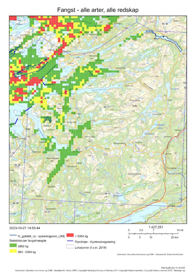
17.1 - Beskrivelse av området
Gytefeltene Innerfolda og Altbotnen er begge klassifisert som nasjonalt viktige grunnet høy eggtetthet og høy retensjon av eggene (A6). Gytefeltene er identifisert i Havforskningsinstituttets eggundersøkelser, men ikke i Fiskeridirektoratets intervjuundersøkelser med fiskere – troligvis siden fiskeriaktiviteten er forholdsvis lav i begge områder. Det er identifisert flere andre gyteområder i lokasjonen utefra intervjuundersøkelsene, særlig i nordlige deler av Folda-området. Det er gyteområdet for både skrei og kysttorsk sør for Vikna (lokasjon 06-12). Det er usikkert hvor regelmessig dette området benyttes av skrei, men et mindre prøvegrunnlag fra fiskeriene i lokasjon 06-37 viser en forholdsvis høy andel skrei i fangsten i gytetiden (Tabell 32).
Innerfolda-feltet er lokalisert i innerste del av Innerfolda, langt fra den åpne kysten. Området er 50-100 m dypt, og mesteparten av området har lavt oksygeninnhold (naturtype «fjorder med naturlig lavt oksygeninnhold i bunnvatnet»). Altbotnen ligger i en mindre arm til Namsenfjorden lengre ut på kysten. Namsenfjorden er rundt 400 m dyp ved innløpet til Altbotnen, men ved Altøya er det en bratt skråning og inne i Altbotn er dybden bare rundt 50 m. I lokasjonen er det identifisert flere mindre bløtbunnsområder og områder med lavt oksygeninnhold. Namsenfjorden er en Nasjonal laksefjord.
Det er ikke gjort DNA-analyser på egg fra dette området, men det foreligger konserverte eggprøver som kan analyseres med hensikt på å indentifisere andelen kysttorsk/skrei. Resultat fra analyser lengre nord i Velfjorden viser en høy andel kysttorsk. Det er også sannsynlig at kysttorsk dominerer i Innerfolda, basert på det generelle mønsteret med mer kysttorsk enn skrei i indre strøk.
Det er ikke kjent om kysttorsken som gyter i området er stasjonær eller migrerende.
17.2 - Kommersiell fiskeriaktivitet
Kvantum torsk fisket i lokasjonen er forholdsvis lavt. Garnfiske fra fartøy < 11 m dominerer fullstendig, med topp i gytetiden (mars-april, Figur 69). Mindre fangster tas i januar-februar og september-desember. Det foreligger få prøver fra fiskeriene; de eneste prøvene er tatt i april og viser at omtrent halvparten av fangsten var skrei (Tabell 32), noe som kan tyde på at mye av fisket i denne perioden foregår i tilknytting til gyteområdene for skrei og kysttorsk vest i lokasjonen. Det er troligvis en større andel kysttorsk i fangsten på høsten, men her mangler det prøvetaking. Det romlige fiskemønsteret i lokasjonen er usikkert da en høy andel av fangsten ikke kunne kobles til sporingsdata (Tabell 33). Av resterende fangst var det ingen fangst av torsk på selve gytefeltene. Det fiskes mer sei og hyse enn torsk i lokasjonen (Tabell 33).
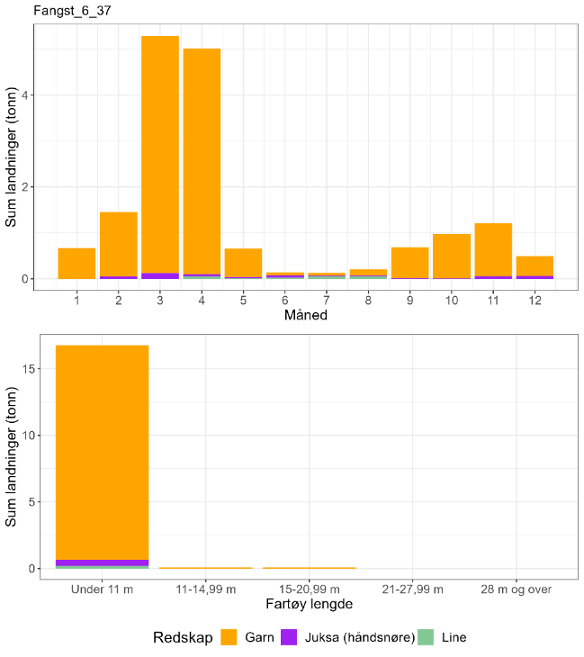
| Måned | Antall kysttorsk i prøve-materiale | Antall skrei i prøve-materiale | Totalt | Andel kysttorsk | Sum sluttseddelvekt (kg) torsk 2018-2022 | Herav kysttorsk (kg) |
| 1 | 0 | 0 | 0 | Ingen data | 667 | Ingen data |
| 2 | 0 | 0 | 0 | Ingen data | 1453 | Ingen data |
| 3 | 0 | 0 | 0 | Ingen data | 5291 | Ingen data |
| 4 | 35 | 43 | 78 | 0,45 | 5015 | 2250 |
| 5 | 0 | 0 | 0 | Ingen data | 655 | Ingen data |
| 6 | 0 | 0 | 0 | Ingen data | 140 | Ingen data |
| 7 | 0 | 0 | 0 | Ingen data | 129 | Ingen data |
| 8 | 0 | 0 | 0 | Ingen data | 206 | Ingen data |
| 9 | 0 | 0 | 0 | Ingen data | 690 | Ingen data |
| 10 | 0 | 0 | 0 | Ingen data | 975 | Ingen data |
| 11 | 0 | 0 | 0 | Ingen data | 1210 | Ingen data |
| 12 | 0 | 0 | 0 | Ingen data | 495 | Ingen data |
| Fangst torsk gyte-område | Fangst sei gyte-område | Fangst hyse gyte-område | Fangst torsk lokasjon | Fangst sei lokasjon | Fangst hyse lokasjon | Prosent fangst i gyte-område torsk | Prosent fangst i gyte-område sei | Prosent fangst i gyte-område hyse | Prosent fangst i sluttseddel uten sporing (alle arter) |
| 0 | 0.1 | 0 | 14 | 251 | 33 | 0 | 0 | 0 | 55 |
17.3 - Rekreasjonsfiske
Data på innsats og uttak i rekreasjonsfiske mangler for området.
Det er registrert 24 turistfiskebedrifter i lokasjonen (Figur 70).
17.4 - Annen menneskelig aktivitet i området
Lokasjonen har 21 oppdrettsanlegg for laks/regnbueørret/ørret i sjø, 3 for torsk, 19 for skjell, og ett for tare (Figur 70). Anleggene for laksefisk har en samlet kapasitet på 74 945 tonn. To av oppdrettsanleggene for torsk ligger innenfor fjordlinjen i Raudsunda, og det tredje ligger utenfor fjordlinjen i Brakstadsundet. De tre anleggene har en samlet kapasitet på 3 900 tonn.
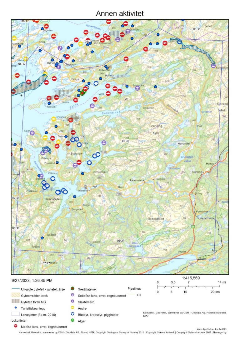
17.5 - Samlet vurdering av menneskelig aktivitet
17.5.1 - Oppsummering av aktivitet
17.5.1.1 - Gytefeltet
Basert på fangsten som kunne kobles til sporingsdata så fiskes det hverken torsk, hyse eller sei på de utvalgte gytefeltene, men grunnet en høy andel fangst uten sporing er dette fiskemønsteret svært usikkert (Tabell 33). På lokasjonsnivå er det nesten utelukkende fartøy < 11 m som fisker torsk, og disse bruker i stort sett garn. Med null fangst estimert innenfor selve gytefeltene så er dette området rangert på (delt) siste plass i forhold til andelen fangst av total torskefangst i lokasjonen som tas innenfor det utvalgte gytefeltet, og kvantum fanget på gytefeltet (Vedlegg 1 og 2). Det bør allikevel tas høyde for stor usikkerhet i anslaget og for at det reelle uttaket i lokasjonen er større siden turist- og fritidsfisket ikke er med i beregningene. Det er tre oppdrettsanlegg for torsk i lokasjonen, men de ligger ikke i direkte tilknytting til gytefeltene. Disse anleggene kan likevel utgjøre en trussel for vill torsk ved f.eks. gyting i merd.
17.5.1.2 - Lokasjonen – innenfor og utenfor fjordlinjen
Begge gytefeltene ligger innenfor fjordlinjen, men store deler av Folda og de ytre områdene mot Vikna ligger utenfor fjordlinjen. Fiskeriaktiviteten som kunne spores i lokasjonen er mest intensiv rundt de ytre kystområdene i nærheten av gyteområdet for skrei og kysttorsk på sør-Vikna, men det er også en del aktivitet lengre inn i Folda-området (Figur 68). Det ble totalt fanget 14 tonn torsk i lokasjonen i perioden 2018-2021, hvorav mesteparten ble tatt i gytetiden (Tabell 33 , inkluderer ikke fangst fra fritids- og turistfiske). Grunnet få prøver fra lokasjonen er det usikkert hvor stor andel av fangsten som er kysttorsk; de få prøvene som foreligger tilsier en høy andel skrei i gytetiden, men siden den romlige fordelingen av fiskeriaktiviteten er så pass usikker er det ikke mulig å si hvor representativt dette er. Fra Vikna har vi bare prøver fra august, som viste 100 % kysttorsk. Det er derfor et tydelig behov for mer prøvetaking i begge lokasjonene. Det er omfattende oppdrett av laksefisk i lokasjonen. I noen tilfeller overlapper anleggene med intervju-baserte gytefelter for torsk, eller ligger i tilknytting til disse.
17.5.2 - Konklusjon
Det mangler informasjon om biomassen av kysttorsk i området, men sammenlignet med de fleste andre lokasjoner fanges det lite torsk her. Samlet sett vurderes den menneskelige aktiviteten til å være liten i selve gyteområdene, men høy i lokasjonen som helhet pga. stor oppdrettsaktivitet og mange turistfiskebedrifter. Det er behov for mer kartlegging av forholdet kysttorsk/skrei i lokasjonen og nabolokasjonen rundt Vikna. Lokasjonen tilhører det sørlige bestandsområdet (62-67°N) som er vurdert til å være i dårligere forfatning enn den nordlige bestanden. Det tilrås derfor at torskefisket på gytefeltene bør holdes på et lavt nivå også fremover.
18 - Sør-Vikna, Trøndelag
Posisjon: 64˚47.9’N, 10˚47.7’E; lokref: 6-12
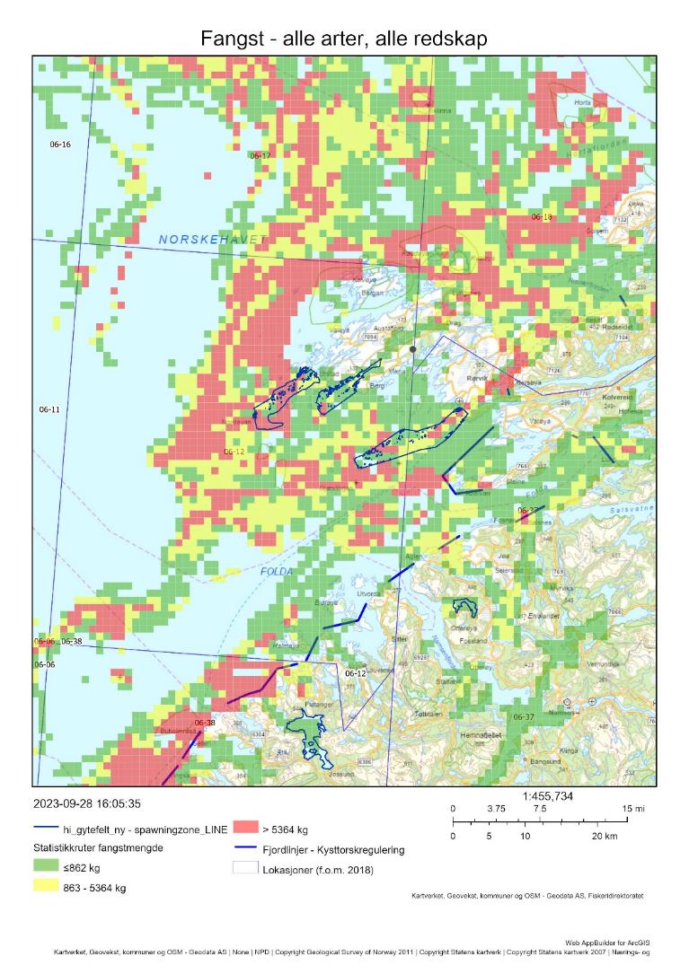
18.1 - Beskrivelse av området
Sammen med Borgundfjorden har Sør-Vikna vært det viktigste torskegyteområdet sør for Lofoten, både for kysttorsk og nordøst-arktisk torsk (skrei). Området inkluderer gytefeltene Benråsa, Tjønna og Sørøyråsa. Alle tre gytefeltene ble under gytefeltkartleggingen i 2019 klassifisert som lokalt viktige gyteområder (C4) med mye egg (3), men med lite tilbakeholdelse av egg (1), dvs at mye av eggene driftet ut av gyteområdene. Fiskeridirektoratets gytefeltkartlegging basert på intervjuundersøkelser med fiskere viser dessuten flere mindre gytefelter mellom de tre nevnte samt vest for Benråsa.
18.2 - Kommersiell fiskeriaktivitet
Figur 72 viser at garn er den helt dominerende redskapen i lokasjonen, og at det meste av torskefangstene tas i månedene mars-april. Siden det ikke er etablert fjordlinjer i Vikna kan alle størrelser av kystfartøy fiske her, men torskefisket domineres av fartøy < 11 meter. Det foreligger svært få prøver fra lokasjonen, men prøver fra august viste 100 % kysttorsk (Tabell 34). Omtrent en tiendel av torskefangsten i lokasjonen i perioden 2018-2021 ble tatt på selve gytefeltet (Tabell 35). Det fiskes mer sei i lokasjonen enn torsk (Tabell 35).
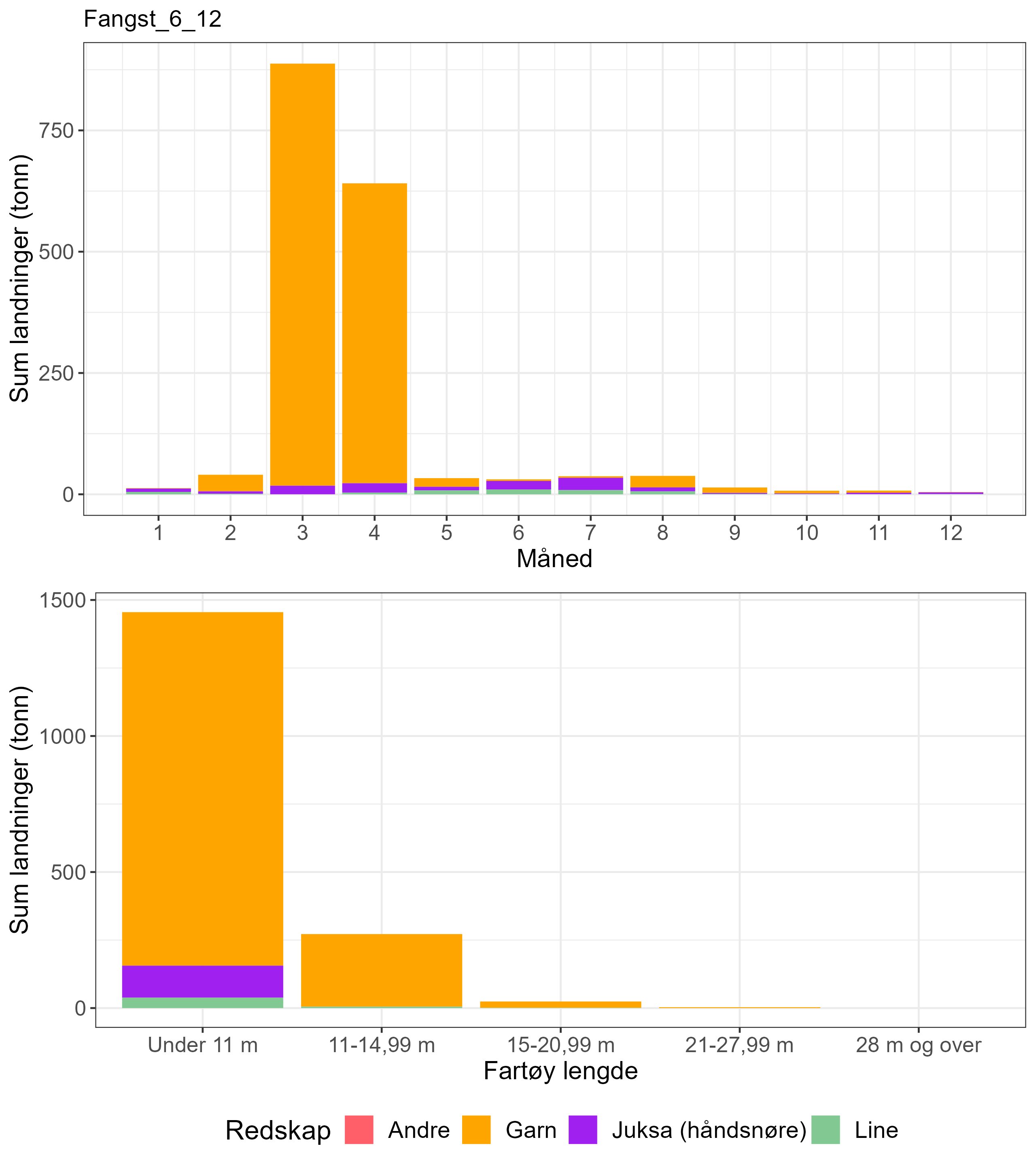
En del av høstingsaktiviteten i Figur 71 er relatert til taretråling. «Store tareskogsforekomster» er definert som en svært viktig naturtype og forekommer hyppig i lokasjonen. Figur 71 viser at det særlig er det vestligste gyteområdet Benråsa og det østligste Sørøyråsa som er mest berørt av fiskeri- og taretrålingsaktivitet. Figur 73 viser dette for bare taretråling. I perioden 2015-2019 var det forbud mot høsting av tare i det skraverte området i Figur 73 (J-171-2015) ut fra føre-var hensyn. Havforskningsinstituttet har i en egen rapport, «Bærekraftig taretråling – vurdering av bærekraftskriterier ved Vikna» (Norderhaug et al. 2021) vurdert taretråling ved Vikna ut fra et bærekraftperspektiv. Konklusjonen var at uttaket av tare gjennom tråling både reduserer biomassen og påvirker tarehabitatets økologiske funksjon, men at effekten er midlertidig og at det kan være mulig å høste tare på en bærekraftig måte. Det var imidlertid et begrenset konklusjonsgrunnlag for å si noe om effekten av taretråling på torsken og dens gyting (se Norderhaug et al. 2021 for detaljer).
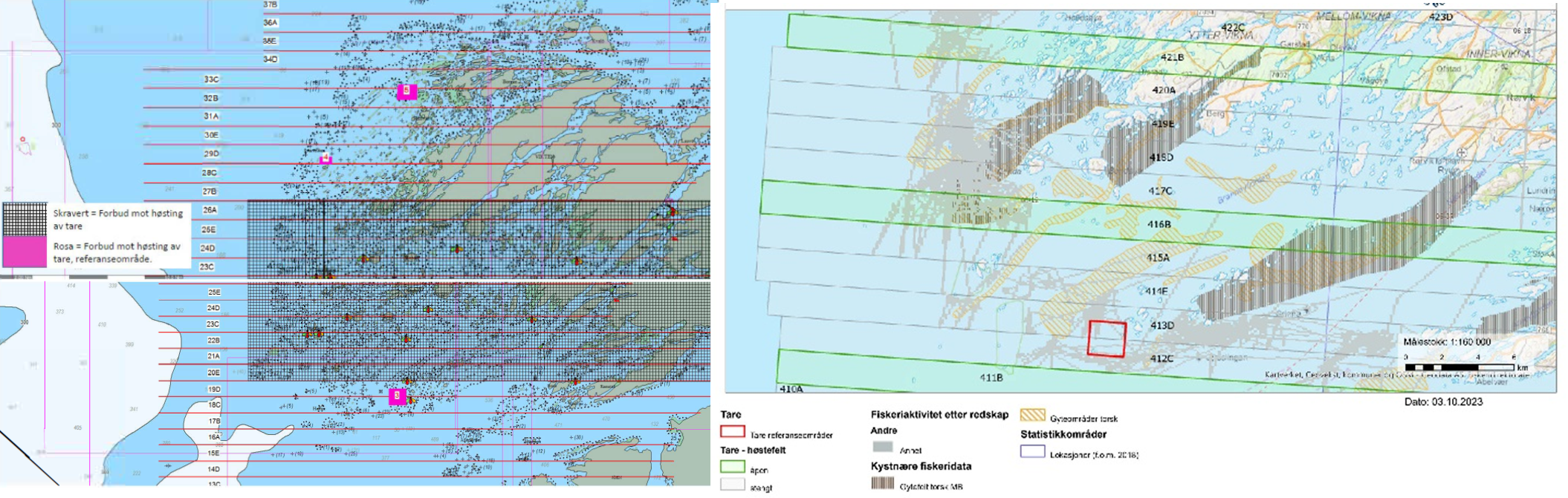
| Måned | Antall kysttorsk i prøve-materiale | Antall skrei i prøve-materiale | Totalt | Andel kysttorsk | Sum sluttseddelvekt (kg) torsk 2018-2022 | Herav kysttorsk (kg) |
| 1 | 0 | 0 | 0 | Ingen data | 12785 | Ingen data |
| 2 | 0 | 0 | 0 | Ingen data | 40325 | Ingen data |
| 3 | 0 | 0 | 0 | Ingen data | 887605 | Ingen data |
| 4 | 0 | 0 | 0 | Ingen data | 640906 | Ingen data |
| 5 | 0 | 0 | 0 | Ingen data | 33288 | Ingen data |
| 6 | 0 | 0 | 0 | Ingen data | 31167 | Ingen data |
| 7 | 0 | 0 | 0 | Ingen data | 37283 | Ingen data |
| 8 | 73 | 0 | 73 | 1 | 37736 | 37736 |
| 9 | 0 | 0 | 0 | Ingen data | 14084 | Ingen data |
| 10 | 0 | 0 | 0 | Ingen data | 7246 | Ingen data |
| 11 | 0 | 0 | 0 | Ingen data | 7605 | Ingen data |
| 12 | 0 | 0 | 0 | Ingen data | 4682 | Ingen data |
| Fangst torsk gyte-område | Fangst sei gyte-område | Fangst hyse gyte-område | Fangst torsk lokasjon | Fangst sei lokasjon | Fangst hyse lokasjon | Prosent fangst i gyte-område torsk | Prosent fangst i gyte-område sei | Prosent fangst i gyte-område hyse | Prosent fangst i sluttseddel uten sporing (alle arter) |
| 186 | 128 | 38 | 1631 | 2197 | 390 | 11 | 6 | 10 | 24 |
18.3 - Rekreasjonsfiske
Data på innsats og uttak i rekreasjonsfiske mangler for området.
Det er registrert minst 8 turistfiskebedrifter i lokasjonen, eller i nabolokasjonen (Figur 74).
18.4 - Annen menneskelig aktivitet i området
Annen menneskelig aktivitet på de aktuelle gytefeltene, herunder akvakultur, turistfiskebedrifter og olje/gass-installasjoner er vist i Figur 74 . Taretråling er omtalt i kapitlet ovenfor om fiskeriaktivitet.
Det er minst 10 oppdrettsanlegg for laks/regnbuørret/ørret som berører de tre gytefeltene (Figur 74). Disse har en samlet kapasitet på 47 580 tonn. Rundt Vikna er det også to oppdrettsanlegg for torsk, der det største ligger på sørsiden i Svinøyfjorden (3120 t).
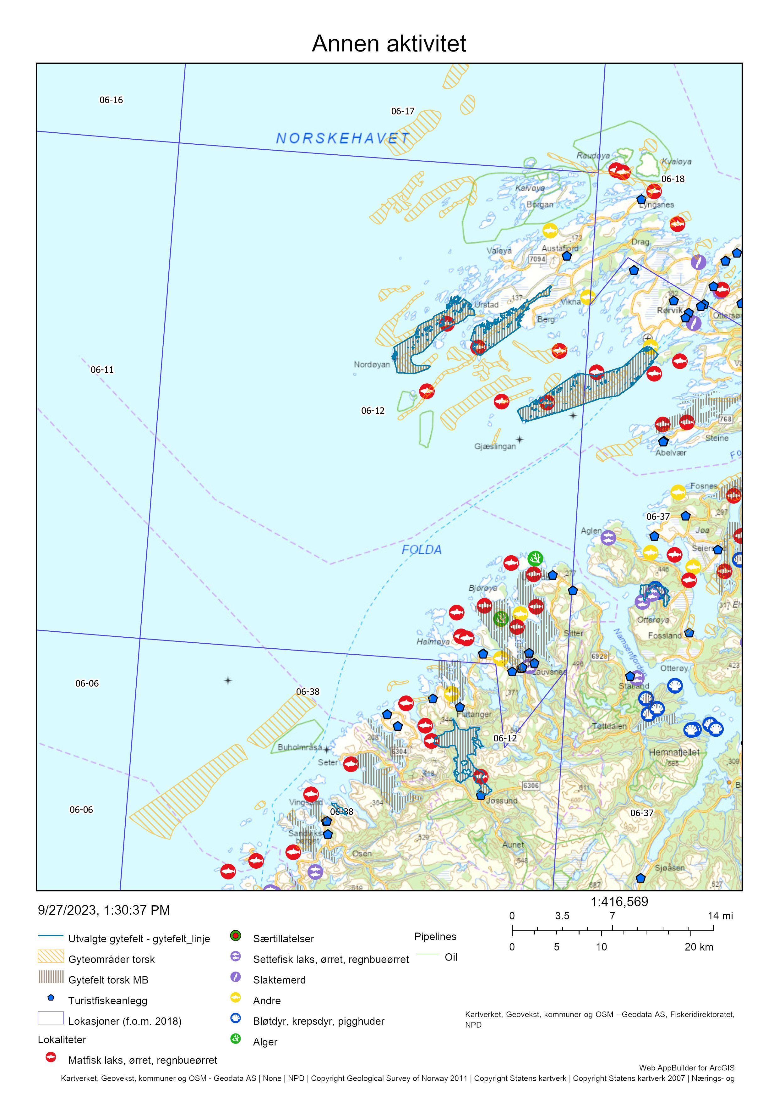
18.5 - Samlet vurdering av menneskelig aktivitet
18.5.1 - Oppsummering av aktivitet
18.5.1.1 - Gytefeltet
Fiske med garn dominerer fullstendig torskefisket som er særlig sesongbetinget, dvs. et labert torskefiske utenom gytesesongen. Siden området ikke omfattes av fjordlinjeregulering så kan fartøy opptil 28 meter i dag fiske på gytefeltet, selv om vi ser at det meste av torskefisket foregår med fartøy under 11 meter. Gytefeltet er rangert på plass 6/22 i forhold til andelen fangst av total torskefangst i lokasjonen som tas innenfor de utvalgte gytefeltene, og plass 3/22 i forhold til kvantum fanget på gytefeltet (Vedlegg 1 og 2). Det anslåtte uttaket på 186 tonn torsk (begge typar) i perioden 2018-2022, dvs. knapt 40 tonn per år, fremstår moderat, men mangelfull prøvetaking gjør det umulig å si hvor mye som er kysttorsk. Det er flere oppdrettsanlegg i sjø innenfor gytefeltene. Nåværende taretråling foregår inne på (særlig) de vestligste gytefeltene, og følgende habitatpåvirkning kan påvirke gytevandring og gyting til torsken.
18.5.1.2 - Lokasjonen – innenfor og utenfor fjordlinjen
Nesten hele lokasjonen, inkludert gytefeltene, ligger utenfor fjordlinjen. Kvantumet av kysttorsk fanget i lokasjonen kan ikke rangeres på grunn av svært mangelfull prøvetaking, men det totale uttaket av torsk er ikke ubetydelig og konsentrert til gytetiden. Det er relativt stor oppdrettsaktivitet av laksefisk i lokasjonen, i tillegg til to anlegg for torskeoppdrett.
18.5.2 - Konklusjon
Det bør foretas rutinemessig prøvetaking av torskefangstene i gytesesongen mars-april for å overvåke forholdet mellom kysttorsk og skrei. Uttaket av torsk i gytefeltene er blant de 6 høyest rangerte i denne kartleggingen. Sammen med Borgundfjorden har Sør-Vikna vært det viktigste torskegyteområdet sør for Lofoten, både for kysttorsk og nordøst-arktisk torsk (skrei). Samlet sett vurderes den menneskelige aktiviteten i området til å være høy, og det tilrås derfor større grad av vern, både i forhold til fiske, oppdrett, og taretråling.
19 - Jøssundfjorden, Trøndelag
Posisjon: 64°24'54"N 10°46'30"E; lokref: 6-38
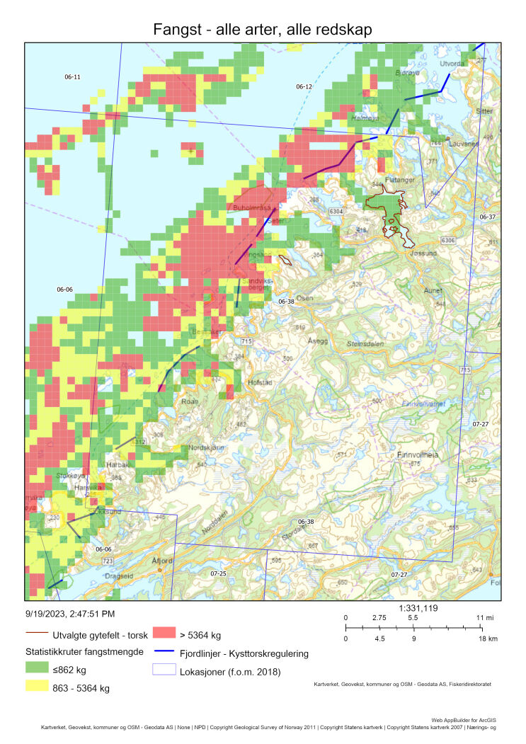
19.1 - Beskrivelse av området
Gytefeltet Jøssundfjorden er klassifisert som nasjonalt viktig grunnet høy eggtetthet og høy retensjon av eggene (A6). Gytefeltet er identifisert i Havforskningsinstituttets eggundersøkelser (2010), men bare den helt innerste delen av fjorden ble registrert ifm. Fiskeridirektoratets intervjuundersøkelser med fiskere (2019) – trolig siden fiskeriaktiviteten er forholdsvis lav i fjorden (Figur 75). Det er identifisert flere andre gytefelt og -områder i lokasjonen. Innenfor fjordlinjene kan særlig nevnes Berfjorden ved Roan, Svesfjorden ved Drageid og Geitøya utenfor Flatanger, alle med gytefeltsverdi B5. Utenfor fjordlinjene, like utenfor ytre skjærgard mellom Bessaker og Flatanger, er det et større gytefelt som p.t. ikke er kartlagt av Havforskningsinstituttet.
Både Jøssundfjorden og Svesfjorden er typiske terskelfjorder, med moderat utskiftning av fjordbassengvatn hvert 2-5. år. Begge fjordene, og også flere andre fjorder i lokasjonen inneholder kommersielle rekefelter.
Kommersiell fiskeriaktivitet
Mesteparten av torskefangstene i lokasjonen blir tatt med garn fra båter < 11 m fra januar-april (Figur 76). En liten del tas også med juksa det meste av året (Figur 76). På gytefeltet i Jøssundfjorden er det liten fiskeaktivitet, mens det er større aktivitet i området utenfor Sandviksberget og i Brandsfjorden (Figur 75). Det må imidlertid understrekes at en svært høy andel av fangsten (57%) ikke kunne kobles mot sporingsdata, og at det geografiske fiskemønsteret dermed blir usikkert (Tabell 37). I perioden 2018-2021 var det ingen fangst av torsk som kunne kobles til det utvalgte gytefeltet i Jøssundfjord (Tabell 37). Det meste av fiskeaktiviteten foregår lenger ute langs fjordlinjegrensene samt på det nevnte gytefeltet lenger til havs.
Havforskningsinstituttet har svært lite data fra torsk i denne lokasjonen som kan dokumentere forholdet mellom kysttorsk og skrei, men det antas at over 90% er kysttorsk hele året basert på den geografiske lokasjonen og et fåtall prøver fra november (Tabell 36).
Det er ikke kjent om kysttorsken som gyter i området er stasjonær eller migrerende.
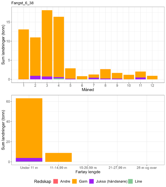
| Måned | Antall kysttorsk i prøve-materiale | Antall skrei i prøve-materiale | Totalt | Andel kysttorsk | Sum sluttseddelvekt (kg) torsk 2018-2022 | Herav kysttorsk (kg) |
| 1 | 0 | 0 | 0 | Ingen data | 13069 | Ingen data |
| 2 | 0 | 0 | 0 | Ingen data | 10988 | Ingen data |
| 3 | 0 | 0 | 0 | Ingen data | 18092 | Ingen data |
| 4 | 0 | 0 | 0 | Ingen data | 16378 | Ingen data |
| 5 | 0 | 0 | 0 | Ingen data | 2871 | Ingen data |
| 6 | 0 | 0 | 0 | Ingen data | 820 | Ingen data |
| 7 | 0 | 0 | 0 | Ingen data | 1261 | Ingen data |
| 8 | 0 | 0 | 0 | Ingen data | 2680 | Ingen data |
| 9 | 0 | 0 | 0 | Ingen data | 1689 | Ingen data |
| 10 | 0 | 0 | 0 | Ingen data | 1191 | Ingen data |
| 11 | 7 | 0 | 7 | 1 | 2048 | 2048 |
| 12 | 0 | 0 | 0 | Ingen data | 923 | Ingen data |
| Fangst torsk gyte-område | Fangst sei gyte-område | Fangst hyse gyte-område | Fangst torsk lokasjon | Fangst sei lokasjon | Fangst hyse lokasjon | Prosent fangst i gyte-område torsk | Prosent fangst i gyte-område sei | Prosent fangst i gyte-område hyse | Prosent fangst i sluttseddel uten sporing (alle arter) |
| 0 | 0.1 | 0 | 66 | 507 | 93 | 0 | < 0.1 | 0 | 57 |
19.2 - Rekreasjonsfiske
Data på innsats og uttak i rekreasjonsfiske mangler for området. I forbindelse med bestandsberegninger av kysttorsk mellom 62-67˚ N er rekreasjonsfisket av kysttorsk antatt å være minst like stort som det kommersielle fisket, dvs. over 4 000 tonn (ICES 2023b).
Det er registrert 16 turistfiskebedrifter i lokasjonen, hvorav en ligger innerst i Jøssundfjorden i tilknytting til gytefeltet der (Figur 77).
19.3 - Annen menneskelig aktivitet i området
Lokasjonen har 17 oppdrettsanlegg for laks/regnbueørret/ørret, spredt langs hele kysten, hvorav ett landbasert anlegg helt sør i lokasjonen (Stokksund), ett for torsk, og ett for blåskjell (Figur 77). Anleggene for laksefisk har en samlet kapasitet på ca 80 000 tonn. To av oppdrettsanleggene for laks/regnbueørret/ørret ligger innenfor gytefeltet i Jøssundfjorden. For tiden ligger det ingen oppdrettsanlegg inne i de to nevnte B5 gytefjordene Berfjorden ved Roan og Svesfjorden ved Drageid. Oppdrettsanlegget for torsk ligger i/ved gytefeltet Geitøya utenfor Flatanger, og har konsesjon på 300 t torsk. Det er ingen byer eller store tettsteder i denne lokasjonen.
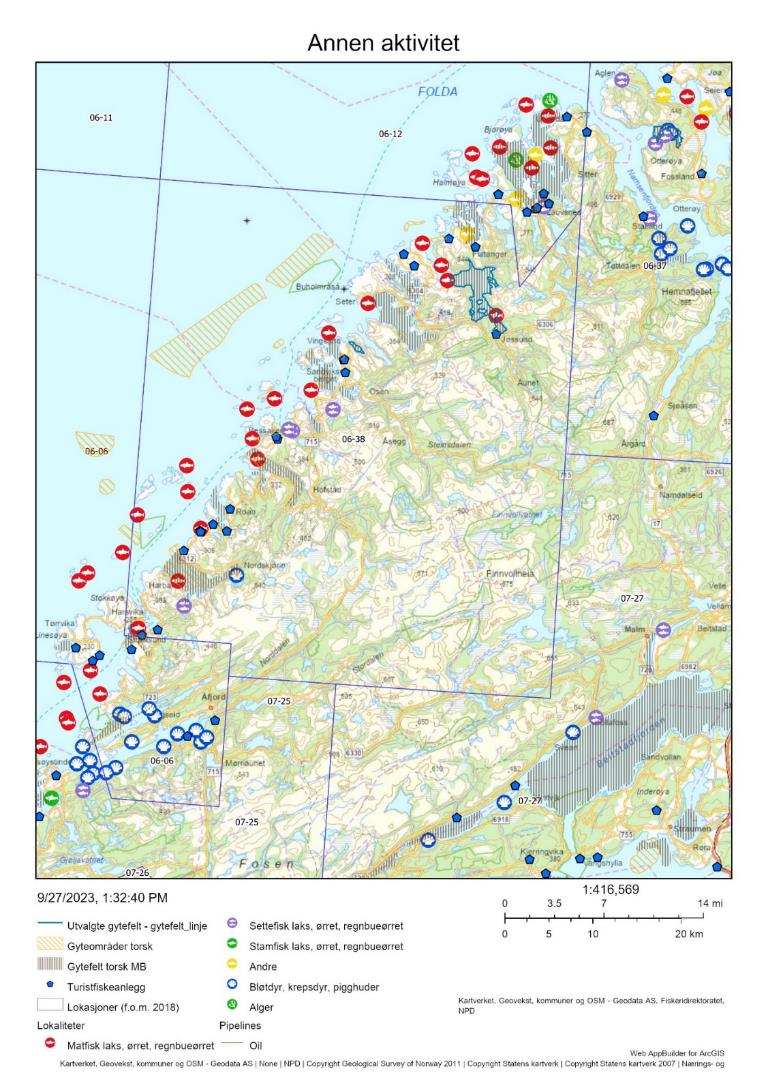
19.4 - Samlet vurdering av menneskelig aktivitet
19.4.1 - Oppsummering av aktivitet
19.4.1.1 - Gytefeltet
Basert på tilgjengelig informasjon så foregår det et svært begrenset garnfiske på gytefeltet i Jøssundfjorden (Figur 75 og Tabell 37), men merk at hele 57% av fangstene i lokasjonen ikke kunne kobles til sporingsdata. Lokasjon 6-38 er rangert sist av de 22 utvalgte lokasjonene i forhold til andelen fangst av total torskefangst i lokasjonen som tas innenfor det utvalgte gytefeltet, og også sist blant de 22 lokasjonene i forhold til kvantum fanget på gytefeltet (Vedlegg 1 og 2).
Det er altså anslått et helt marginalt uttak av torsk på gytefeltet i Jøssundfjorden i perioden 2018-2021, men det bør allikevel tas høyde for stor usikkerhet i anslaget, og for at det reelle uttaket er større siden turist- og fritidsfisket ikke er med i beregningene. Da viser imidlertid Figur 75 at det er større fiskeaktivitet på gytefeltene Berfjorden ved Roan, Svesfjorden ved Drageid og Geitøya utenfor Flatanger, selv om disse har en litt lavere gytefeltsverdi (B5) enn Jøssundfjorden (A6). Det samme gjelder for det ytre gytefeltet like utenfor ytre skjærgard mellom Bessaker og Flatanger. Dette feltet er imidlertid ikke verdisatt.
Oppdrettsanlegget for torsk ligger i/ved torskegytefeltet Geitøya utenfor Flatanger, og kan dermed påvirke den ville torskens gyting på dette gytefeltet. I gytefeltet for torsk i Jøssundfjorden ligger det ett oppdrettsanlegg for laksefisk, og ett til ligger like ved yttergrensen til gytefeltet.
19.4.1.2 - Lokasjonen – innenfor og utenfor fjordlinjen
Mesteparten av gytefeltene til kysttorsk i lokasjonen ligger innenfor fjordlinjen, mens om lag 30% av arealet til lokasjon 6-38 ligger utenfor fjordlinjene (Figur 75). Det ble totalt bare fanget omtrent 66 tonn torsk i lokasjonen i perioden 2018-2021, hvorav over 90 % antas å være kysttorsk hele året (Tabell 37, inkluderer ikke fangst fra fritids- og turistfiske). Dette rangerer lokasjonen på plass 167 av 563 blant lokasjoner på kysten der det fiskes kysttorsk (Vedlegg 2). På lokasjonsnivå er det fartøy < 11 m som dominerer, mens fartøy 11-14,99 m står for under 10 % av det totale uttaket av torsk.
I tillegg til gytefelt Jøssundfjorden, ligger det også oppdrettsanlegg for laksefisk på/like ved gytefeltene Brandsfjorden og Skjørafjorden, samt det store landbaserte anlegget i Stokksundet, som ligger like ved det viktige gytefeltet der.
19.4.2 - Konklusjon
Det mangler informasjon om biomassen av kysttorsk i området, men i likhet med nærliggende lokasjoner så er det grunn til å forvente at fiskepresset er – i hvert fall lokalt – høyt. Lokasjon 6-38 tilhører det sørlige bestandsområdet (62-67°N) som er vurdert til å være i dårligere forfatning enn den nordlige bestanden. Det tilrås å vurdere utvidet fredning i gytetiden (f.eks. innenfor fjordlinjen) for å redusere det totale uttaket av gytetorsk i lokasjonen. Siden det synes å være liten fiskeaktivitet inne på gytefeltet Jøssundfjorden, så bør evt. reguleringer også knyttes til de andre B5 gytefeltene. Gytefelter med verdi B5 eller A6 er viktige gytefelter uansett, og det kan være naturlige års variasjoner som avgjør verdisettingen det året som dette gytefeltet ble vurdert. Gytefelter ved Bessaker og Stokksundet kan beskyttes bedre ved hjelp av justerte fjordlinjer.
Risikoen knyttet til torskeoppdrett er i stor grad avhengig av mengde fisk i sjø og plassering av anleggene. Det er for tiden bare et oppdrettsanlegg for torsk i lokasjonen, med en begrenset tillatelse til 300 tonn. Siden dette anlegget ligger i et av de viktigste gytefeltene (B5) for vill kysttorsk i lokasjonen så anbefales det at det stilles krav til bruk av lukket anlegg dersom kontroller avdekker negativ miljøpåvirkning eller risiko for rømming, eller ved evt. utvidelse.
20 - Erviksva, Frøya, Trøndelag
Posisjon: 63°45'18"N 8°51'42"E; lokref: 7-8
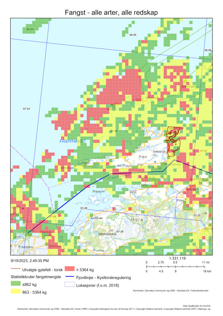
20.1 - Beskrivelse av området
Gytefeltet Erviksva er i klassifisert som lokalt viktig (C4) grunnet mye egg og lite retensjon. Området har blitt identifisert som gytefelt både i Havforskningsinstituttet sine undersøkelser og i Fiskeridirektoratets intervjuundersøkelser av fiskere. Det er flere lokalt viktige gytefelt rundt Frøya, og det er observert gytende torsk av fiskere i store deler av lokasjonen.
Sammen med feltene på Sør-Vikna utgjør Ervikva de eneste lokalt viktige gytefeltene som er plukket ut i denne rapporten. I utvalget av gytefelt har vi fokusert på de nasjonalt viktige, som oftest er plassert inne i fjorder og bidrar til å opprettholde populasjonsstrukturen og den lokale produksjonen av torsk. I motsetning til dette er feltene rundt Frøya og Vikna ikke like isolert, og bidrar derfor i større grad til å spre egg både inn mot og langs kysten. Disse områdene har likevel blitt valgt ut for å oppnå en balansert spredning av gytefeltene langs kysten, og for å inkludere hva som mest sannsynlig er gytefelter for vandrende kysttorsk. I området har det foregått prosjektarbeid innenfor aktiv forvaltning med mål om å styrke kunnskapsgrunnlaget for kommunene i kystsoneplanleggingen og identifisere mulige bevaringsområder på Hitra og Frøya (Kleiven, 2021). Fra prosjektet foreligger det data fra nåværende situasjon (før ev. vern) samlet inn med agnede stereo-video rigger (2018-2020) og havteiner (2019 og 2020). Samlet gir dette gode muligheter for videre overvåking av området for å vurdere og kvantifisere effekt av vern.
Sluttrapporten fra prosjektet «Aktiv forvaltning av marine ressurser, Hitra og Frøya» presenterer et konkret forslag om å etablere et verneområde i området Sistranda-Uttian-Inntian, som delvis dekker det utvalgte gytefeltet (Kleiven et al. 2021). Prosjektet la til grunn flere hensyn enn gytefelt for torsk ved utarbeiding av forslag til verneområder. Det vises til Kleiven et al. (2021) for flere detaljer rundt arbeidet.
Rundt Frøya og de mindre øyene i Frøyhavet er det store områder med skjellsand og/eller tareskog, to svært viktige naturtyper som kan utgjøre viktige oppvekstområder for torsk.
Det foreligger konserverte eggprøver fra gytefeltet som kan analyseres med hensikt på å indentifisere andelen kysttorsk/skrei. Andelen skrei er sannsynligvis lav med tanke på den geografiske plasseringen.
Det er ikke fullstendig kartlagt om det er vandrende eller mer stasjonær kysttorsk som gyter i området, men det er troligvis en større komponent av migrasjon her sammenlignet med gyteområdene lengre inn på kysten.
20.2 - Kommersiell fiskeriaktivitet
Mesteparten av den kommersielle fangsten av torsk i lokasjonen tas med garn av fartøy < 11 m i gytetiden (Figur 79). Det fiskes også en del torsk med line, særlig under gyting i april, både fra de minste fartøyene og i gruppen 11-14,99 m. Fangst med juksa skjer utelukkende fra fartøy < 11 m, har topp i februar og utgjør over halvparten av fangsten registrert i juli (Figur 79). Det foreligger svært få biologiske prøver fra fangster i lokasjonen. Prøvene som er tatt fra oktober-november var utelukkende kysttorsk (Tabell 38).
En stor del av fiskeriaktiviteten foregår nord i lokasjonen, men det er også relativt høy aktivitet på det utvalgte gytefeltet (Figur 78 og Figur 80). Anslagvis 8 % av de totale torskefangstene i lokasjonen 2018-2021 ble tatt på det utvalgte gytefeltet (Tabell 39).
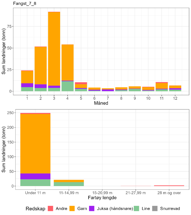
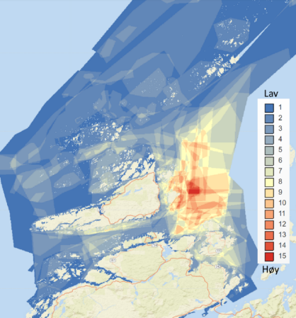
| Måned | Antall kysttorsk i prøve-materiale | Antall skrei i prøve-materiale | Totalt | Andel kysttorsk | Sum sluttseddelvekt (kg) torsk 2018-2022 | Herav kysttorsk (kg) |
| 1 | 0 | 0 | 0 | Ingen data | 24169 | Ingen data |
| 2 | 0 | 0 | 0 | Ingen data | 51683 | Ingen data |
| 3 | 0 | 0 | 0 | Ingen data | 91984 | Ingen data |
| 4 | 0 | 0 | 0 | Ingen data | 54147 | Ingen data |
| 5 | 0 | 0 | 0 | Ingen data | 10383 | Ingen data |
| 6 | 0 | 0 | 0 | Ingen data | 4205 | Ingen data |
| 7 | 0 | 0 | 0 | Ingen data | 3355 | Ingen data |
| 8 | 0 | 0 | 0 | Ingen data | 4580 | Ingen data |
| 9 | 0 | 0 | 0 | Ingen data | 5671 | Ingen data |
| 10 | 5 | 0 | 5 | 1 | 5219 | 5219 |
| 11 | 7 | 0 | 7 | 1 | 10616 | 10616 |
| 12 | 0 | 0 | 0 | Ingen data | 6748 | Ingen data |
| Fangst torsk gyte-område | Fangst sei gyte-område | Fangst hyse gyte-område | Fangst torsk lokasjon | Fangst sei lokasjon | Fangst hyse lokasjon | Prosent fangst i gyte-område torsk | Prosent fangst i gyte-område sei | Prosent fangst i gyte-område hyse | Prosent fangst i sluttseddel uten sporing (alle arter) |
| 16 | 4.5 | 3.7 | 211 | 7893 | 200 | 8 | 0 | 2 | 23 |
20.3 - Rekreasjonsfiske
De sørvestlige delene av gytefeltet er et populært område for fritidsfiskere (Figur 81). Det er registrert rundt 40 turistfiskebedrifter i lokasjonen, hvorav fire er lokalisert innenfor det utvalgte gyteområdet (Figur 82), men deres aktivitet ser ut å være konsentrert rundt Hitra og vest for Frøya (Figur 81). Kvantitativ kartlegging av innsats og uttak i rekreasjonsfiske mangler for området
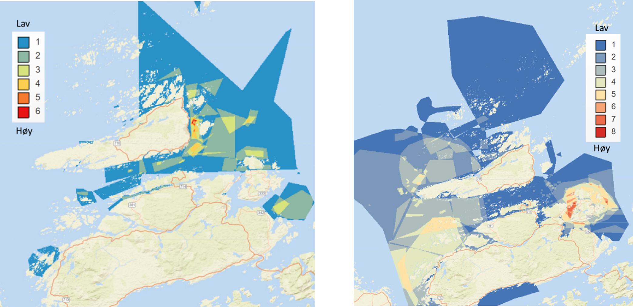
20.4 - Annen menneskelig aktivitet i området
Det er plassert 54 oppdrettsanlegg i lokasjonen med en total kapasitet i underkant av 170 000 tonn, der 43 driver oppdrett på laks/regnbueørret/ørret (11 960 t innenfor gytefeltet), 4 på torsk (samlet kapasitet 9 840 t), og 7 dyrker alger. Alle oppdrettsanleggene for torsk (gule sirkler med fiskesymbol i Figur 82) er plassert i nærheten av eller innenfor gytefelt for vill torsk.
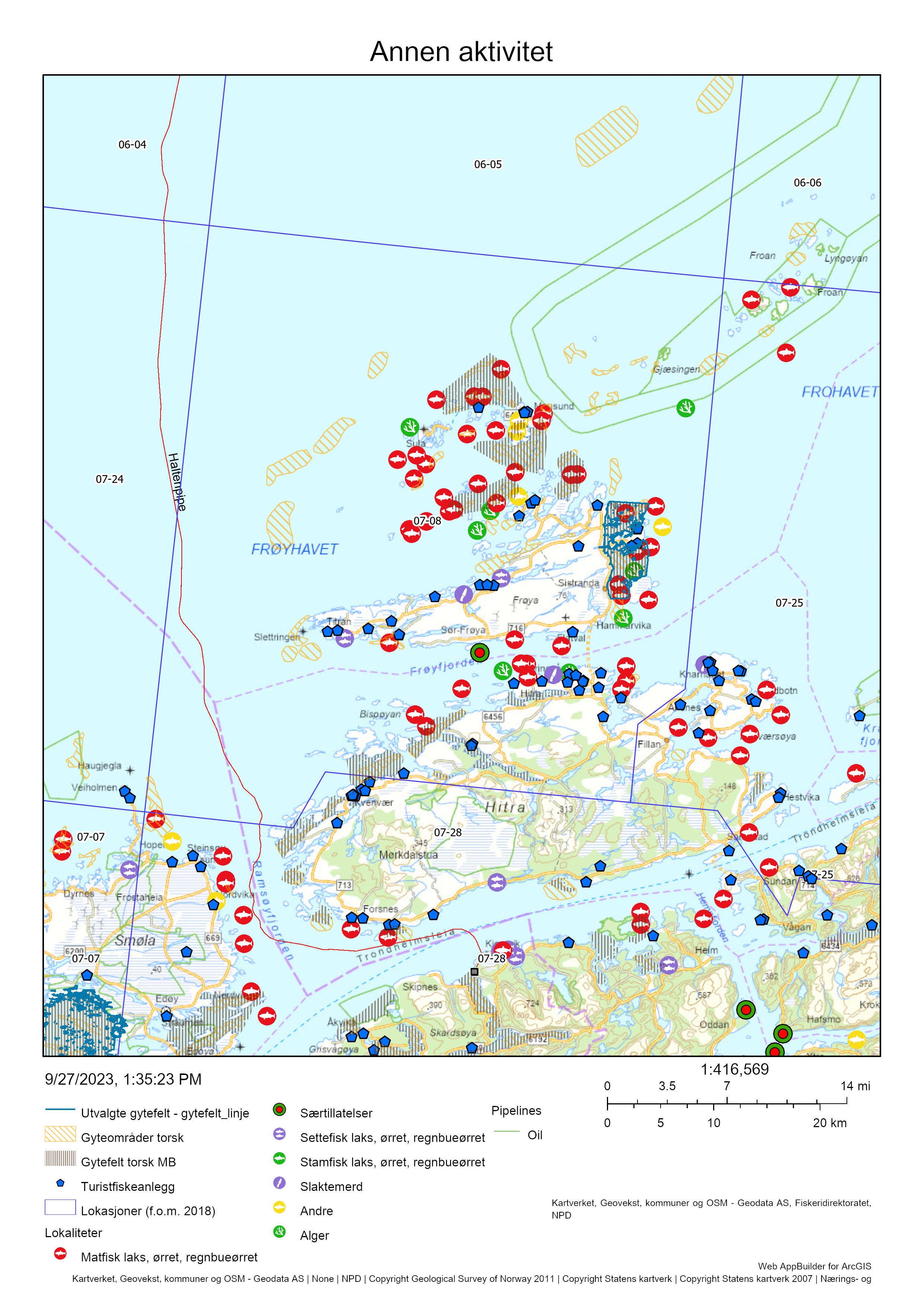
20.5 - Samlet vurdering av menneskelig aktivitet
20.5.1 - Oppsummering av aktivitet
20.5.1.1 - Gytefeltet
Det fiskes torsk på gytefeltet i gytetiden. På lokasjonsnivå er det garnfiske fra fartøy < 11 m som dominerer, men i april fanges opp mot en fjerdedel av torsken med line. Gytefeltet er rangert på plass 8/22 i forhold til andelen fangst av total torskefangst i lokasjonen som tas innenfor det utvalgte gytefeltet, og på plass 11/22 i forhold til kvantum fanget på gytefeltet (Vedlegg 1 og 2). Det anslåtte uttaket på 16 tonn i perioden 2018-2022 utgjør 8 % av det totale uttaket av torsk i lokasjonen. Det bør tas høyde for at det reelle uttaket kan være betydelig større siden det er et stort antall turistfiskebedrifter registrert i lokasjonen. Det er stor aktivitet innenfor lakseoppdrett i området, også i selve gytefeltet.
20.5.1.2 - Lokasjonen – innenfor og utenfor fjordlinjen
Gytefeltet og mesteparten av lokasjonen ligger utenfor fjordlinjen. Fiskeriaktiviteten i lokasjonen er mest intensiv i de nordlige og nordvestlige områdene, men det er også relativt stor aktivitet på gytefeltene for torsk rundt Frøya. Det fiskes mye sei i lokasjonen (Tabell 39), og det antas at Figur 78 i stor grad gjenspeiler dette fisket. Det ble totalt fanget omtrent 210 tonn torsk i lokasjonen i perioden 2018-2021, der andelen kysttorsk er usikker men trolig svært høy (Tabell 38 , inkluderer ikke fangst fra fritids- og turistfiske). Dette gir en rangering på plass 150 av 563 blant lokasjoner på kysten det det fiskes torsk (Vedlegg 3). Det er svært stor oppdrettsaktivitet i lokasjonen som i stor grad overlapper med gytefeltene til vill torsk. Dette gjelder også de fire anleggene for torskeoppdrett, som utgjør en særlig stor trussel med tanke på risiko for genetisk påvirkning på villtorsken.
20.5.2 - Konklusjon
Det mangler informasjon om biomassen av kysttorsk i området, men sett opp mot den forholdsvis store torskefangsten er det grunn til å forvente at fiskepresset i lokasjonen er – i hvert fall lokalt – høy. Samlet sett vurderes den menneskelige aktiviteten til å være svært høy både i selve gyteområdet og generelt i lokasjonen. Lokasjonen tilhører det sørlige bestandsområdet (62-67°N) som er vurdert til å være i dårligere forfatning enn den nordlige bestanden. Det tilrås en fredning i gytetiden for å redusere det totale uttaket av gytetorsk i lokasjonen. Et slikt tiltak bør ses i sammenheng med fredning av gytefelt på Smøla og Hitra, der en utvidelse/modifisering av fjordlinjen kan være hensiktsmessig. I tillegg bør det med hensyn til torsken og annen vill fisk i området ikke etableres flere oppdrettsanlegg rundt Frøya og Hitra. Det er klarert for produksjon av nesten 10 000 tonn oppdrettstorsk i lokasjonen, noe som – for å sette det i perspektiv – er 3 000 tonn mer enn den anslåtte fangsten (kommersiell fangst, fritids- og turistfiske) av kysttorsk i hele området 62-67°N.
Basert på ovenstående er det stor potensiale for å studere effekter av vern i området, og dette gjelder også for andre arter om vernet er fullstendig som skissert i rapporten fra Havforskningsinstituttet (Kleiven, 2021).
21 - Blåsværsvaet, Smøla, Møre og Romsdal
Posisjon: 63°19'00"N 8°06'06"E; lokref: 7-7

21.1 - Beskrivelse av området
Gytefeltet Blåsværsvaet er klassifisert som regionalt viktig (B5) grunnet mye egg og noe retensjon. Lokalt kan dette området ha høy retensjon (van der Meeren, 2021). Området er identifisert som gytefelt både i egg- og intervjuundersøkelser. Det er flere andre gytefelt rundt Smøla, enten identifisert av fiskere eller av Havforskningsinstituttet (se Figur 85). Øst for Blåsværsvaet ligger gyteområdet Lauvøysvaet, klassifisert som lokalt viktig.
Rundt Smøla er det funnet store forekomster av de svært viktige naturtypene tareskog, skjellsand og bløtbunnsområde i strandsonen, som er gunstige oppvekstområder for torsk (Dunlop et al. 2022). Havforskningsinstituttet har utført både egg- og yngelundersøkelser i området i forbindelse med ICOD-prosjektet som studerte effekter av lakseoppdrett på vill torsk, inkludert DNA-analyser for å undersøke om yngelen kunne skilles i genetiske grupper (van der Meeren, 2021). Det ble ikke funnet genetiske forskjeller mellom yngel fra ulike gyteområder, noe som tilsier at torsk som gyter rundt Smøla blander seg med hverandre. Området er sannsynligvis oppvekstområde både for lokalt gytt torsk og for yngel som er ført dit med kyststrømmen fra sør. Området har en stor andel førstegangsgytere, noe som kan tyde på høy fiskepress (van der Meeren, 2021).
Prøver fra fiskeriene tilsier at det er kysttorsk som gyter i området ( Tabell 40 ). I ICOD-prosjektet ble det registrert noen få skrei (< 2 %) blant gytemoden torsk i 2018 og 2019 basert på otolittlesing, mens all torsk ble klassifisert som kysttorsk basert på DNA-analyse. Dette tilsier at «skreien» var kysttorsk med en otolittfasong som kunne forveksles med skreien. Dette kan være en vandrende variant av kysttorsk, men denne hypotesen må testes i egnete feltundersøkelser/eksperimenter.
21.2 - Kommersiell fiskeriaktivitet
Samlet for alle arter er fiskeriaktiviteten høy på mange steder i lokasjonen (Figur 83). Til sammenligning er fiskeriaktiveten på Blåsværsvaet lav, mens den er høy på de andre gytefeltene rundt Smøla (Figur 83, de andre gytefeltene vises i Figur 85).
Liksom i de fleste andre utvalgte områder er det garnfiske med fartøy < 11 m som dominerer fangstene i lokasjonen, og det fiskes mest i starten av året rett før og under gytetiden (Figur 84). Det er allikevel en større andel av fangsten som ble tatt med line, juksa, snurrevad og andre redskap sammenlignet med de fleste andre områder i denne rapporten. Gruppen «andre» domineres av fangst med ruser og teiner som utgjør en relativt stor del av fangsten i januar-mars og oktober-desember. Omtrent halvparten av totalfangsten tas i januar-mars mens resten av fangstene er fordelt utover resten av året med topp i april og november (Figur 84). Biologiske prøver foreligger fra februar-mai, juli og november, og var utelukkende kysttorsk (Tabell 40).
Estimert fangst inne på det utvalgte gytefeltet er omtrent 10 % av totalfangsten av torsk i lokasjonen (Tabell 41). Merk at dette er en mye større andel enn man skulle tro utefra Figur 83. Dette skyldes at fiskemønstret i Figur 83 sannsynligvis domineres av de store seifangstene i lokasjonen (Tabell 41).
| Måned | Antall kysttorsk i prøve-materiale | Antall skrei i prøve-materiale | Totalt | Andel kysttorsk | Sum sluttseddelvekt (kg) torsk 2018-2022 | Herav kysttorsk (kg) |
| 1 | 0 | 0 | 0 | Ingen data | 141928 | Ingen data |
| 2 | 60 | 0 | 60 | 1 | 175098 | 175098 |
| 3 | 40 | 0 | 40 | 1 | 170216 | 170216 |
| 4 | 20 | 0 | 20 | 1 | 80805 | 80805 |
| 5 | 20 | 0 | 20 | 1 | 54361 | 54361 |
| 6 | 0 | 0 | 0 | Ingen data | 40408 | Ingen data |
| 7 | 60 | 0 | 60 | 1 | 36029 | 36029 |
| 8 | 0 | 0 | 0 | Ingen data | 54394 | Ingen data |
| 9 | 0 | 0 | 0 | Ingen data | 29094 | Ingen data |
| 10 | 0 | 0 | 0 | Ingen data | 55233 | Ingen data |
| 11 | 2 | 0 | 2 | 1 | 71838 | 71838 |
| 12 | 0 | 0 | 0 | Ingen data | 53990 | Ingen data |
| Fangst torsk gyte-område | Fangst sei gyte-område | Fangst hyse gyte-område | Fangst torsk lokasjon | Fangst sei lokasjon | Fangst hyse lokasjon | Prosent fangst i gyte-område torsk | Prosent fangst i gyte-område sei | Prosent fangst i gyte-område hyse | Prosent fangst i sluttseddel uten sporing (alle arter) |
| 80 | 72 | 25.5 | 828 | 29361 | 657 | 10 | 0 | 4 | 10 |
21.3 - Rekreasjonsfiske
Data på innsats og uttak i rekreasjonsfiske mangler for området.
Det er registrert 50 turistfiskebedrifter i lokasjonen, hvorav to ligger innenfor det utvalgte gyteområdet (Figur 85). Det er derfor grunn til å anta at det er et betydelig uttak av torsk i rekreasjonsfisket.
21.4 - Annen menneskelig aktivitet i området
Innenfor lokasjonen er det 14 oppdrettsanlegg for laks/regnbueørret/ørret i sjø med en samlet kapasitet på 59 710 tonn, hvorav tre er plassert i eller nære gyteområdet (18 720 tonn, Figur 85). I tillegg er det fire anlegg for algedyrking i lokasjonen.
ICOD-prosjektet undersøkte torsk i Smøla-området med tanke på påvirkning fra lakseoppdrett. Laksefôr er laget av en høy andel fôringredienser fra jordbruk med forskjellig fettsyreprofil enn marint fôrråstoff. Ut fra analyse av fettsyrer ble det funnet at 20 % av torsken hadde beitet på laksefôr og hadde større lever og økt lipidinnhold sammenlignet med torsk som spiste i de naturlige næringskjedene (van der Meeren, 2021; Meier et al. 2023). Det ble likevel ikke påvist en økt investering i gonadevekst hos torsk som spiste laksefôr. Det ble funnet endret fettsyreprofil i gonadene hos torsk som spiste laksefôr, og det er ukjent hvordan reproduksjonssuksessen eventuelt påvirkes av denne typen diett. De relativt dynamiske vannmassene i området med transport av egg og larver fra andre gyteområder kan maskere eventuelle negative effekter av oppdrett på vill torsk.
På østsiden av Smøla samt helt vest i lokasjonen er det plassert ledninger for olje/gass.

21.5 - Samlet vurdering av menneskelig aktivitet
21.5.1 - Oppsummering av aktivitet
21.5.1.1 - Gytefeltet
Det fiskes torsk på gytefeltet i gytetiden. På lokasjonsnivå er det fartøy < 11 m som dominerer. Det fiskes mest torsk med garn, men det tas også en god del torsk med andre redskap inkludert teiner og ruser. Gytefeltet er rangert på plass 7/22 i forhold til andelen fangst av total torskefangst i lokasjonen som tas innenfor det utvalgte gytefeltet, og på plass 6/22 i forhold til kvantum fanget på gytefeltet (Vedlegg 1 og 2). Det anslåtte uttaket på 80 tonn i perioden 2018-2022 utgjør 10 % av det totale uttaket av torsk i lokasjonen. Det bør tas høyde for at det reelle uttaket kan være betydelig større siden det er et stort antall turistfiskebedrifter registrert i lokasjonen. Det er plassert tre oppdrettsanlegg for laksefisk rundt gytefeltet, og det har blitt påvist laksefôr i dietten til 1 av 5 torsk som ble undersøkt rundt Smøla.
21.5.1.2 - Lokasjonen – innenfor og utenfor fjordlinjen
Mesteparten av gytefeltene i lokasjonen ligger innenfor fjordlinjen. Fiskeriaktiviteten i lokasjonen er mest intensiv rundt de sørlige gyteområdene, samt rundt det lokalt viktige feltet Lauvøysvaet som ligger øst for det utvalgte gyteområdet i lokasjon 07-28 (Figur 83 og Figur 85). Det ble totalt fanget omtrent 830 tonn torsk i lokasjonen i perioden 2018-2021, hvorav alt er anslått til å være kysttorsk (Tabell 40, inkluderer ikke fangst fra fritids- og turistfiske). Dette gir en rangering på plass 53 av 563 lokasjoner der det fiskes torsk og otolittmateriale finnes for å skille mellom kysttorsk og skrei (Vedlegg 2). Oppdrettsanlegg for laksefisk er konsentrert på nord- og østsiden av Smøla samt rundt Kristiansund i sør.
21.5.2 - Konklusjon
Det mangler informasjon om biomassen av kysttorsk i området, men sett opp mot den forholdsvis store torskefangsten og den høye andelen førstegangsgytere er det grunn til å forvente at fiskepresset i lokasjonen er – i hvert fall lokalt – høyt. Samlet sett vurderes den menneskelige aktiviteten til å være høy både i selve gyteområdet og generelt i lokasjonen. Lokasjonen tilhører det sørlige bestandsområdet (62-67°N) som er vurdert til å være i dårligere forfatning enn den nordlige bestanden. Det tilrås her en utvidet fredning i gytetiden, f.eks. på alle gytefelt innenfor fjordlinjen, for å redusere det totale uttaket av gytetorsk i lokasjonen. Et slikt tiltak bør ses i sammenheng med fredning av gytefelt på Frøya og Hitra, der en utvidelse/modifisering av fjordlinjen kan være hensiktsmessig. Det tilrås også å utvise stort hensyn til vill torsk ved eventuell etablering av nye oppdrettsanlegg i lokasjonen.
22 - Midsund, Gossen, Møre og Romsdal
Posisjon: 62°42.3’N, 6°39.8’E; lokref: 7-31
22.1 - Beskrivelse av området
Gytefeltet Misund er klassifisert som et regionalt viktig gytefelt med middels mye egg med stor tilbakeholdelse av eggene (B5). Gytefeltet er identifisert i både Havforskningsinstituttets eggundersøkelser (2017), og i Fiskeridirektoratets intervjuundersøkelser med fiskere (2012). Det er identifisert et titalls andre gytefelt og -områder i lokasjonen, herav to gytefelt med samme verdi (B5) som Misund gytefelt. Disse er Vatnefjorden og Smågevågen på vestsiden av øya Gossa (Figur 88). Også utenfor fjordlinjene, like utenfor ytre skjærgard, er det gytefelt som ennå ikke er kartlagt av Havforskningsinstituttet. Merk at omtrent halvparten av lokasjonsarealet ligger utenfor fjordlinjene.
Deler av Misund gytefelt ligger innenfor terskel, som er grunnen til at det er stor tilbakeholdelse av egg. Flere fjorder i lokasjonen inneholder kommersielle rekefelter med p.t. lave rekeforekomster.
Figur 86 viser relativ stor fiskeaktivitet på gytefelt Misund, til liks med flere andre gytefelt i lokasjonen. Det tas også store fangster av særlig sei, men også hyse i lokasjonen, men lite av disse artene inne på gytefeltet til torsken.
Det er gjort observasjoner av koraller i Midfjorden og Julsundet.
22.2 - Kommersiell fiskeriaktivitet
Mesteparten av torskefangstene i lokasjonen (ca 76%) er rapportert fisket med båter < 11 m fra januar-april (Figur 87), ca 15% er rapportert fisket med båter mellom 11-14,99 m, og 9% med båter mellom 15-20,99 m.
Denne lokasjonen skiller seg ut fra de andre lokasjonene i denne rapporten ved at en stor del av torsken fiskes med snurrevad. Figur 87 viser at 48% av torskefangsten i 2018-2022 ble fisket med snurrevad, og andelen tatt med snurrevad er økende (72% i 2022). Snurrevad er den dominerende redskapen for fartøy over 11 meter. Snurrevad er også den dominerende redskapen i alle måneder bortsett fra i gytetiden februar-april da mesteparten blir fisket med garn. En liten del tas med juksa og line over det meste av året (Figur 87).
Det meste av torsken blir fisket i januar-april, i forbindelse med gytingen, men i månedene oktober-desember fiskes det også en god del torsk. Line kommer inn som den nest viktigste redskapen etter snurrevad i desember. Ifølge Tabell 43 så tas bare 3% (19 av 643 tonn) av all torskefangst i lokasjonen på gytefeltet Misund, men det må her nevnes at 25% av alle fiskefangster i lokasjonen ikke kunne kobles mot sporingsdata og dermed fordeles geografisk innenfor lokasjonen.
Havforskningsinstituttet har lite biologiske data på torsken i denne lokasjonen, men prøvene viser over 90% kysttorsk, også i gytetiden (Tabell 42).
Det er ikke kjent om kysttorsken som gyter i området er stasjonær eller migrerende.
| Måned | Antall kysttorsk i prøve-materiale | Antall skrei i prøve-materiale | Totalt | Andel kysttorsk | Sum sluttseddelvekt (kg) torsk 2018-2022 | Herav kysttorsk (kg) |
| 1 | 0 | 0 | 0 | Ingen data | 110059 | Ingen data |
| 2 | 30 | 0 | 30 | 1 | 188843 | 188843 |
| 3 | 28 | 2 | 30 | 0,93 | 211647 | 197537 |
| 4 | 0 | 0 | 0 | Ingen data | 99374 | Ingen data |
| 5 | 0 | 0 | 0 | Ingen data | 40127 | Ingen data |
| 6 | 0 | 0 | 0 | Ingen data | 32110 | Ingen data |
| 7 | 0 | 0 | 0 | Ingen data | 27087 | Ingen data |
| 8 | 0 | 0 | 0 | Ingen data | 26912 | Ingen data |
| 9 | 2 | 0 | 2 | 1 | 18541 | 18541 |
| 10 | 0 | 0 | 0 | Ingen data | 59550 | Ingen data |
| 11 | 1 | 0 | 1 | 1 | 60827 | 60827 |
| 12 | 0 | 0 | 0 | Ingen data | 42928 | Ingen data |
| Fangst torsk gyte-område | Fangst sei gyte-område | Fangst hyse gyte-område | Fangst torsk lokasjon | Fangst sei lokasjon | Fangst hyse lokasjon | Prosent fangst i gyte-område torsk | Prosent fangst i gyte-område sei | Prosent fangst i gyte-område hyse | Prosent fangst i sluttseddel uten sporing (alle arter) |
| 19 | 7 | 4 | 643 | 3283 | 549 | 3 | 0 | 1 | 25 |
22.3 - Rekreasjonsfiske
Data på innsats og uttak i rekreasjonsfisket mangler for området. I forbindelse med bestandsberegninger av kysttorsk mellom 62-67˚ N er rekreasjonsfisket av kysttorsk antatt å være minst like stort som det kommersielle torskefisket, det vil si over 4 000 tonn (ICES 2023b).
Det er registrert hele 50 turistfiskebedrifter i lokasjonen, hvorav fire ligger ved gytefeltet Misund (Figur 88).
22.4 - Annen menneskelig aktivitet i området
Lokasjonen har 20 oppdrettsanlegg for laks/regnbueørret/ørret, spredt langs hele kysten, hvorav ett stort landbasert anlegg helt nord i lokasjonen (ved Bud) og ett mindre landbasert anlegg øst i lokasjonen (Furland i Vestnes). Det er også ett anlegg for kveite og ett for rognkjeks på Otrøya, ett for torsk (3120 tonn) ved Fjørtofta, fem for alger/tare, ett landbasert for hummer, sjøkreps og taskekrabbe på Midøya med forbindelse til gytefeltet Midsund og ett stort (17900 tonn) for havbeite av hummer utenfor fjordlinjene vest av Harøya (Figur 88). Anleggene for laksefisk har en samlet kapasitet på ca 85 000 tonn. Ingen av oppdrettsanleggene for laks/regnbueørret/ørret ligger innenfor de tre gytefeltene med høyest verdi i lokasjonen.
Nyhamna prosessanlegg er ilandføringssted for gass fra petroleumsfeltene Ormen Lange og Aasta Hansteen. Anlegget ligger nordøst på Gossa i Aukra kommune. På den andre siden av øya ligger de viktige gytefeltene for torsk, Smågevågen og Hjertevika. Ifølge Store Norske Leksikon blir det i anlegget utført gasstørking, komprimering, kondensatutskilling, stabilisering, lagring og skattemessig måling av naturgass og kondensat. Gassen fraktes videre til Easington gassterminal i Storbritannia gjennom rørledningen Langeled (Bryhni 2005-2007).
Det er ingen byer eller store tettsteder i denne lokasjonen, men lokasjonen grenser opp til Molde i øst og Ålesund i sørvest
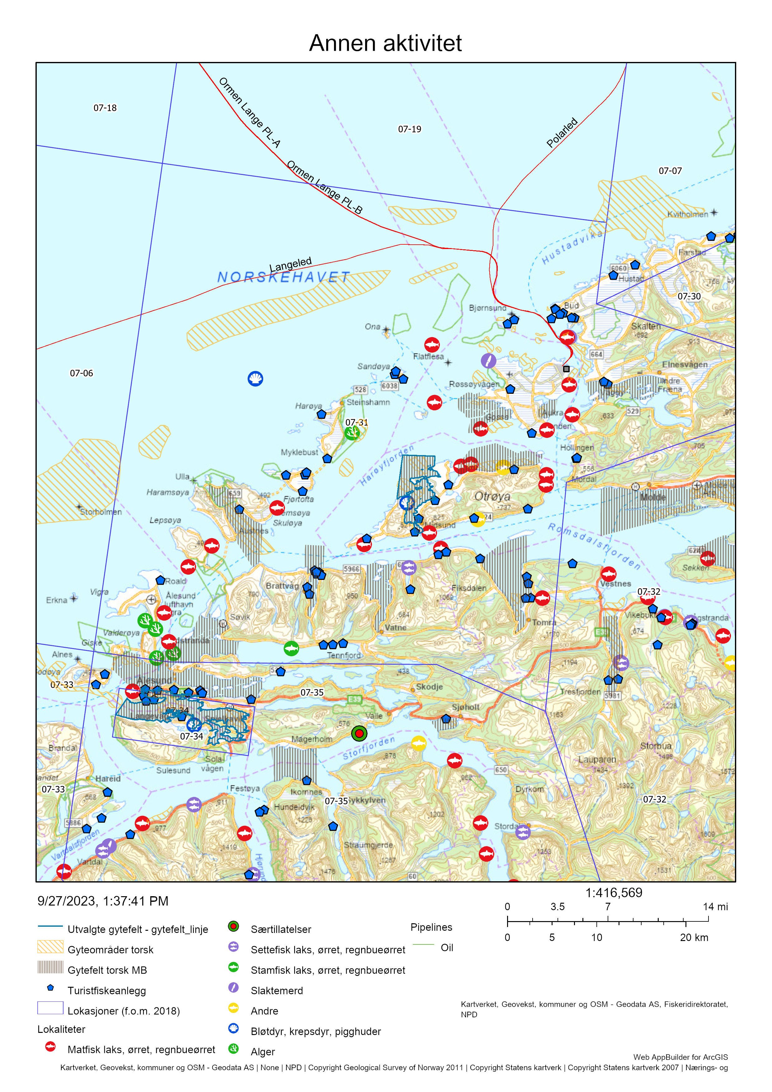
22.5 - Samlet vurdering av menneskelig aktivitet
22.5.1 - Oppsummering av aktivitet
22.5.1.1 - Gytefeltet
Lokasjon 7-31 er rangert som nummer 10 av de 22 utvalgte lokasjonene i forhold til andelen fangst av total torskefangst i lokasjonen som tas innenfor det utvalgte gytefeltet, og i forhold til kvantum fanget på gytefeltet (Vedlegg 1 og 2). Figur 86 viser at det er relativ stor fiskeinnsats inne på Misund-gytefeltet. Det samme gjelder innerst inne på gytefeltet Vatnefjorden.
22.5.1.2 - Lokasjonen – innenfor og utenfor fjordlinjen
Mesteparten av gytefeltene til kysttorsk i lokasjonen ligger innenfor fjordlinjen. Utenfor fjordlinjen er det flere kjente gytefelter for torsk like utenfor ytre skjærgard fra vest av Godøya i sør via vest for Lepsøya/Haramsøya, vest/nordvest for Ona og videre nordover mot Fuglen på Hustadvika.
Det ble totalt fisket 643 tonn torsk i lokasjonen i perioden 2018-2021, hvorav nesten alt anslås å være kysttorsk (Tabell 43, inkluderer ikke fangst fra fritids- og turistfiske). Dette rangerer lokasjonen på plass 65 av 563 blant lokasjoner på kysten der det fiskes kysttorsk (Vedlegg 2).
22.5.2 - Konklusjon
Det mangler informasjon om biomassen av kysttorsk i området, men sett opp mot den forholdsvis store torskefangsten er det grunn til å forvente at fiskepresset i lokasjonen – i hvert fall lokalt – er høy. Samlet sett vurderes den menneskelige aktiviteten til å være høy i gyteområdene Midsund og Vatnefjorden. Lokasjon 7-31 tilhører det sørlige bestandsområdet (62-67°N) som er vurdert til å være i dårligere forfatning enn den nordlige bestanden. Det tilrås å vurdere utvidet fredning i gytetiden (f.eks. innenfor fjordlinjen) for å redusere det totale uttaket av gytetorsk i lokasjonen. I sørvestre hjørne av lokasjonen kan det være hensiktsmessig å flytte fjordlinjene noe lenger ut for bedre å beskytte gytefeltene fra Vigra via Runde mot Sandsøya i nabolokasjonen (jfr. konklusjonen i kapitlet om Borgundfjorden).
For tiden er det bare ett sjøanlegg for torskeoppdrett, og dette ligger i bra avstand til kjente gytefelt for torsk. Anlegget har konsesjon til inntil 3 120 tonn torsk som er en stor mengde sammenlignet med en totalfangst på 7 735 tonn i 2021 av vill kysttorsk langs hele kysten mellom 62-67N. Med såpass store kvantumstillatelser så tilrås det merking av oppdrettstorsken slik at evt. rømming eller gyting i merd kan spores. Det anbefales at forvaltningen og myndighetene i større grad stiller krav til bruk av lukkede anlegg ved fremtidig tildeling av konsesjoner for torskeoppdrett.
Norsk fritidsfiske og turistfiske kan utgjøre over halvparten av det totale uttaket av kysttorsk på kyststrekningen mellom 62-67˚ N. Da er det særdeles viktig at vi får gode tall på dette fisket. For å oppnå dette må register over turistfiskebedrifter oppdateres hvert år, stikkprøver må tas av bedriftenes pålagte fangstrapportering, og det må øremerkes årlige bevillinger til kartlegging og mengdemåling av rekreasjonsfisket på sjø, f.eks. et fylke per år. Havforskningsinstituttet vil gjennomføre en slik kartlegging av Møre og Romsdal fylke i 2024. Eventuelt gytefeltvern bør også gjelde for turist- og fritidsfiske.
Med økende bruk av det aktive redskapet snurrevad på Møre, også i denne lokasjonen, så bør de foreslåtte tekniske reguleringene for denne redskapen straks innføres. Aktive redskaper som snurrevad frarås inne på gytefeltene til torsk.
23 - Borgundfjorden, Ålesund, Møre og Romsdal
Posisjon: 62˚27.5’N, 6˚12.0’E); lokref: 7-34
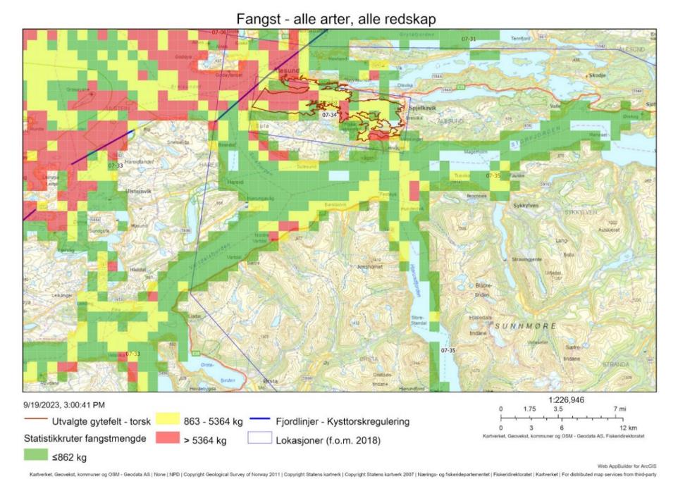
23.1 - Beskrivelse av området
Ifølge Myklebust (1971) har det blitt fisket torsk i Borgundfjorden helt tilbake i steinalderen. Borgundfjorden var også frem til ca 1830 sentrum for vintertorskefisket på Møre. Mens Borgundfjorden før hadde vært et samlingssted for fiskere i hele fylket, fikk fjorden heretter størst verdi for de som budde rundt fjorden. Borgundfjordfisket har dabbet av, men historier om toppår da konsentrasjonen av fiskebåter var så stor at man nesten kunne gå tørrskodd fra båt til båt over fjorden, lever. Det samme gjør håpet om nye gode år for Borgundfjordfisket. Med andre ord et viktig marint miljø for lokalsamfunnet med rike kulturhistoriske fisketradisjoner.
Borgundfjorden er klassifisert som et nasjonalt viktig gytefelt (A6) for torsk, med mye egg (3) og stor tilbakeholdelse av egg (3). Gyteområdet er verifisert flere ganger, både av fiskere, Havforsknings-instituttet og Fiskeridirektoratet. Gyteområdet har på grunn av det historisk viktige sesongfisket/ gytefisket fått sin egen fangstlokasjon 07-34.
Johansen et al. (2018) og Aannø i sin masteroppgave fra 2020 viser resultat fra flere år (siden 2012) med systematisk datainnsamling av torsken som gyter i Borgundfjorden for å overvåke utviklingen av kysttorskpopulasjonen som gyter her (Figur 90).
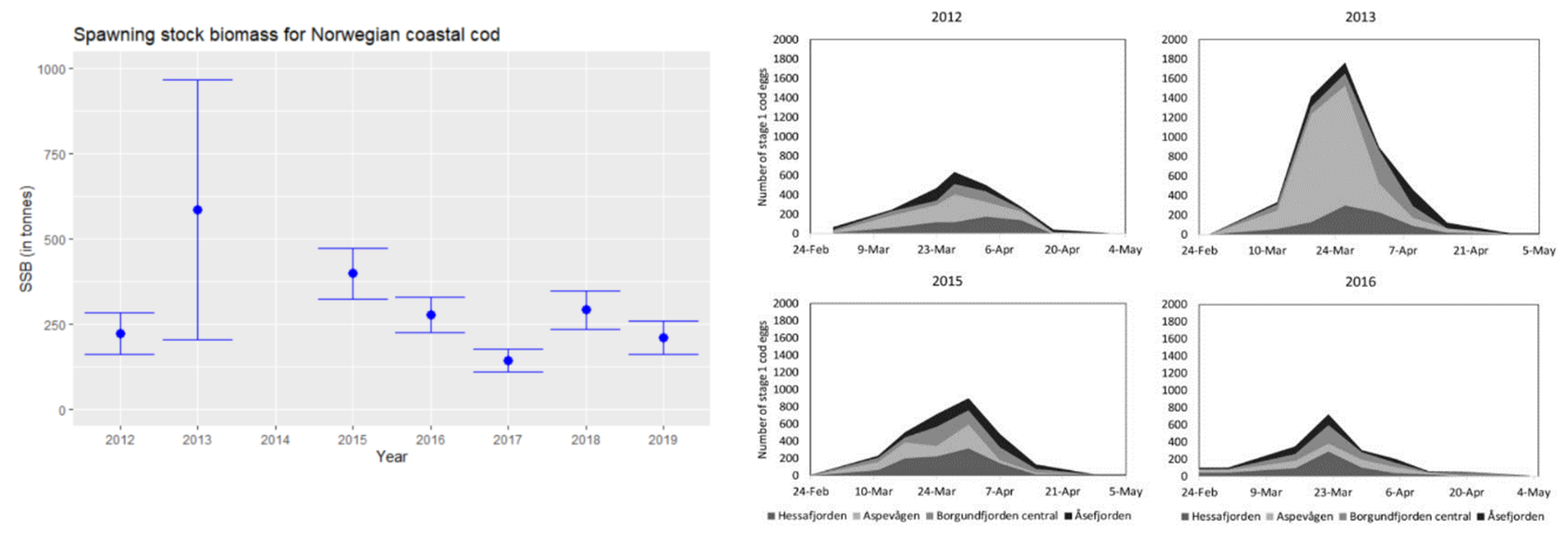
I forskriften for torskefiske nord for Stad (J-162-2023) står det at «Fra og med 1. mars til og med 31. mai er alt fiske forbudt i et område i Borgundfjorden som er angitt i vedlegg til forskriften nevnt i første ledd (d.e. innenfor en rett linje mellom Langevåg og Slinningsodden), også etter andre arter enn torsk, hyse og sei. Forbudet gjelder likevel ikke fiske med håndsnøre, fiskestang eller fiske etter sjøkreps med teiner med sirkelformede inngangskalver som ikke er større en 80 mm i diameter. Fiskeridirektoratet kan gjøre unntak fra forbudet for fartøy som fisker med andre konvensjonelle redskap enn snurrevad dersom det anses å være vesentlige konsentrasjoner av skrei i området». Gyteområdet har siden denne forskriften ble innført i 2009 aldri blitt åpnet for annet fiske enn det som her er beskrevet siden det aldri har kommet så mye skrei inn på gytefeltet.
23.2 - Kommersiell fiskeriaktivitet
Figur 91 viser at det er garn som er den dominerende redskap i det kommersielle fisket i lokasjon 07-34, men i gyteperioden 1.3-31.5 får man bare lov å fiske med håndsnøre, fiskestang eller etter sjøkreps innenfor en rett linje mellom Langevåg og Slinningsodden. Det fiskes svært lite i lokasjonen utenom gyteperioden. Tabell 44 viser at det aller meste som fiskes av torsk er kysttorsk.
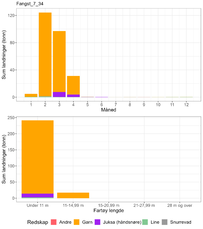
| Måned | Antall kysttorsk i prøve-materiale | Antall skrei i prøve-materiale | Totalt | Andel kysttorsk | Sum sluttseddelvekt (kg) torsk 2018-2022 | Herav kysttorsk (kg) |
| 1 | 0 | 0 | 0 | Ingen data | 4795 | Ingen data |
| 2 | 148 | 2 | 150 | 0,99 | 124239 | 122582 |
| 3 | 642 | 71 | 713 | 0,90 | 97002 | 87342 |
| 4 | 64 | 11 | 75 | 0,85 | 31108 | 26545 |
| 5 | 0 | 0 | 0 | Ingen data | 575 | Ingen data |
| 6 | 0 | 0 | 0 | Ingen data | 205 | Ingen data |
| 7 | 0 | 0 | 0 | Ingen data | 23 | Ingen data |
| 8 | 0 | 0 | 0 | Ingen data | 87 | Ingen data |
| 9 | 0 | 0 | 0 | Ingen data | 65 | Ingen data |
| 10 | 0 | 0 | 0 | Ingen data | 60 | Ingen data |
| 11 | 0 | 0 | 0 | Ingen data | 271 | Ingen data |
| 12 | 0 | 0 | 0 | Ingen data | 352 | Ingen data |
| Fangst torsk gyte-område | Fangst sei gyte-område | Fangst hyse gyte-område | Fangst torsk lokasjon | Fangst sei lokasjon | Fangst hyse lokasjon | Prosent fangst i gyte-område torsk | Prosent fangst i gyte-område sei | Prosent fangst i gyte-område hyse | Prosent fangst i sluttseddel uten sporing (alle arter) |
| 61 | 34 | 8 | 217 | 29 | 12 | 28 | 118 | 64 | 63 |
23.3 - Rekreasjonsfiske
Data på innsats og uttak i rekreasjonsfiske har manglet for området, men etter to år med systematisk kartlegging og datainnsamling ventes det foreløpige resultat kring nyttår 2024. Disse dataene vil bidra i debatten om hvorvidt effekten av gytevernet på gjenoppbygging av den lokale gytebestanden har blitt redusert som følge av et økende rekreasjonsfiske.
Det er registrert et 10-talls turistfiskeanlegg i lokasjonen (Figur 92), som er pålagt å rapportere fangsten til turistene daglig til Fiskeridirektoratet.
23.4 - Annen menneskelig aktivitet i området
At dette gyteområdet til dels ligger i havneområdet til en stor by som Ålesund (67 447 innbyggere per 31.12.2022) krever kontinuerlig overvåkning mht kloakkutslipp og annen forurensning. Man må også utvise stor forsiktighet med mudring og undervannsprengning som kan skade det unike gytehabitatet. Det er ingen oppdrettsanlegg inne i lokasjonen (Figur 92).
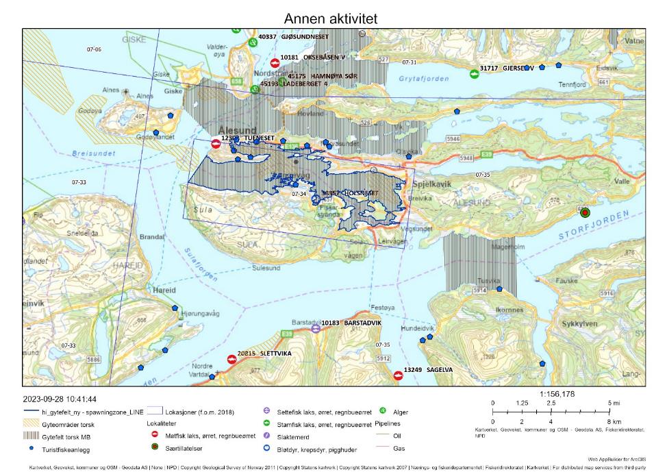
23.5 - Samlet vurdering av menneskelig aktivitet
23.5.1 - Oppsummering av aktivitet
23.5.1.1 - Gytefeltet
Det foregår et garnfiske etter torsk med fartøy < 15 meter i hele fjorden før 1. mars, og i liten grad etter 31. mai. I perioden 1. mars-31. mai er det bare tillatt med garnfiske i gytevandringsruta til torsken i ytre deler av fjorden, men med snøre- og stangfiske i hele lokasjonen.
Gytefeltet er rangert på plass 1/22 i forhold til andelen fangst av total torskefangst i lokasjonen som tas innenfor de utvalgte gytefeltene, og plass 7/22 i forhold til kvantum fanget på gytefeltet (Vedlegg 1 og 2). Det anslåtte uttaket på ca 40 tonn kysttorsk per år i perioden 2018-2021 er lavt sett opp mot biomasse-indeksen av kysttorsk i området, om lag 250 tonn (Aannø 2020). Det bør imidlertid tas høyde for at det reelle uttaket er betydelig større når turist- og fritidsfisket tas med i beregningene og for at en stor andel av fangst fra fartøy < 15 m ikke kunne kobles til sporingsdata.
23.5.1.2 - Lokasjonen - innenfor og utenfor fjordlinjen
Hele lokasjonen ligger innenfor fjordlinjen. Det anslåtte kvantumet av kysttorsk fanget i lokasjonen er rangert på plass 93 av 563 lokasjoner på kysten det det fiskes torsk (Vedlegg 2).
23.5.2 - Konklusjon
Etter 14 år med gytefeltsvern i Borgundfjorden ser det ut til at vernet i beste fall har hindret en videre nedgang, men det er ikke tegn til gjenoppbygging. Et økende fritidsfiske i verneområdet (foreløpige beregninger av dette ventes klare rundt nyttår 2024), og et åpent fiske utenfor verneområdet kan bremse på en ønsket gjenoppbygging. Det kan i denne sammenheng være hensiktsmessig med en fjordlinjeregulering i et større område langs kysten fra Sunnfjord i sør til Kristiansund N i nord i perioden januar-april (ref. høringssvar til Fiskeridirektoratet 1.3.2023), samt begrensning av fritidsfisket. Torsken starter gyting i slutten av februar, og det foreslås derfor også å starte vernet litt tidligere, f.eks. 1. eller 15. februar, for å gi et bedre vern for torskens forberedelser til gyting. Det er svært viktig at forvaltningen innenfor og utenfor et gyteområde er integrert, så langt det er mulig og relevant, slik at også fiskepresset utenfor gyteområdet begrenses dersom gytepopulasjonen reduseres.
24 - Referanser
Aannø, WA. 2020. Cod spawning in the Borgundfjord Marine Protected Area - Estimation of the spawning stock biomass, and an evaluation of the Marine Protected Area and the fluctuations in the spawning stock biomass from year to year. Master thesis at Department of Biological Sciences, University of Bergen, June 2020. 77 pp.
Breistein, B., Dahle, G., Johansen, T., Besnier, F., Quintela, M., Jorde, P. E., . . . Glover, K. A. (2022). Geographic variation in gene flow from a genetically distinct migratory ecotype drives population genetic structure of coastal Atlantic cod (Gadus morhua L.). Evolutionary Applications, 15(7), 1162-1176. doi: https://doi.org/10.1111/eva.13422
Bryhni, Inge; Store norske leksikon (2005-2007): Nyhamna prosessanlegg i Store norske leksikon på snl.no. Hentet 26. januar 2024 fra https://snl.no/Nyhamna_prosessanlegg
Dahle, G., Quintela, M., Johansen, T., Westgaard, J.-I., Besnier, F., Aglen, A., . . . Glover, K. A. (2018). Analysis of coastal cod (Gadus morhua L.) sampled on spawning sites reveals a genetic gradient throughout Norway’s coastline. BMC Genetics, 19(1), 42. doi:10.1186/s12863-018-0625-8
Direktoratet for naturforvaltning 2007. Kartlegging av marint biologisk mangfold. DN Håndbok 19-2001 Revidert 2007. 51 s (https://www.miljodirektoratet.no/publikasjoner/andre/kartlegging-av-marint-biologisk-mangfold/)
Dunlop, K., Staby, A., van der Meeren, T., Keeley, N., Olsen, E. M., Bannister, R., & Skjæraasen, J. E. 2022. Habitat associations of juvenile Atlantic cod (Gadus morhua L.) and sympatric demersal fish communities within shallow inshore nursery grounds. Estuarine, Coastal and Shelf Science, 279 , 108111. doi: https://doi.org/10.1016/j.ecss.2022.108111
Espeland, S. H., Albretsen, J., Nedreaas, K., Sannæs, H., Bodvin, T., og Moy, F. 2013. Kartlegging av gytefelt - Gytefelt for kysttorsk. 2013. Fisken og havet : 1-2013, 43 s. https://imr.brage.unit.no/imr-xmlui/handle/11250/113915
Farkas, J., Nordtug, T., Svendheim, L. H., Amico, E. D., Davies, E. J., Ciesielski, T., . . . Hansen, B. H. 2021. Effects of mine tailing exposure on early life stages of cod (Gadus morhua) and haddock (Melanogrammus aeglefinus). Environmental Research , 200, 111447. doi: https://doi.org/10.1016/j.envres.2021.111447
Grefsrud, E. S., Andersen, L. B., Bjørn, P. A., Grøsvik, B. E., Hansen, P. K., Husa, V., Karlsen, Ø. Kvamme, B. O., Samuelsen, O., Sandlund, N., Solberg, M. F., og Stien, L. H. 2022a. Risikorapport norsk fiskeoppdrett 2022 – risikovurdering. Rapport fra havforskningen: 2022-12, 235 s. https://www.hi.no/hi/nettrapporter/rapport-fra-havforskningen-2022-12
Grefsrud, E. S., Bjørn, P. A., Grøsvik, B. E., Hansen, P. K., Husa, V., Karlsen, Ø. Kvamme, B. O., Samuelsen, O., Sandlund, N., Solberg, M. F., og Stien, L. H. 2022b. Risikorapport norsk fiskeoppdrett 2022 – kunnskapsstatus. Rapport fra havforskningen: 2022-13, 406 s. https://www.hi.no/hi/nettrapporter/rapport-fra-havforskningen-2022-13
ICES. 2023a. Cod (Gadus morhua) in subareas 1 and 2, north of 67°N (Norwegian Sea and Barents Sea), northern Norwegian coastal cod. In Report of the ICES Advisory Committee, 2023. ICES Advice 2023 , cod.27.1-2.coastN. https://doi.org/10.17895/ices.advice.21828306
ICES. 2023b. Cod (Gadus morhua) in Subarea 2 between 62°N and 67°N (Norwegian Sea), southern Norwegian coastal cod. In Report of the ICES Advisory Committee, 2023. ICES Advice 2023, cod.27.1-2coastS, https://doi.org/10.17895/ices.advice.21828309
Johansen, T., Westgaard, J.-I., Seliussen, B. B., Nedreaas, K., Dahle, G., Glover, K. A., Kvalsund, R., et al. 2018. “Real-time” genetic monitoring of a commercial fishery on the doorstep of an MPA reveals unique insights into the interaction between coastal and migratory forms of the Atlantic cod. ICES Journal of Marine Science, 75: 1093-1104. doi: https://doi.org/10.1093/icesjms/fsx224
Johansen, T., Besnier, F., Quintela, M., Jorde, P. E., Glover, K. A., Westgaard, J.-I., . . . Kent, M. P. (2020). Genomic analysis reveals neutral and adaptive patterns that challenge the current management regime for East Atlantic cod Gadus morhua L. Evolutionary Applications, 13(10), 2673-2688. doi: https://doi.org/10.1111/eva.13070
Kleiven, A. R., Espeland, S. H., Søvik, G., Albretsen, J., Kleiven, P. J. N., Zimmermann, F., Grefsrud, E. S., Halvorsen, K. A., T. (HI) og Vie, O. (Guri Kunna VGS / Trøndelag fylkeskommune). 2021. Aktiv forvaltning av marine ressurser - Frøya og Hitra — Sluttrapport. 2021. Rapport fra havforskningen 2021-14 ISSN: 1893-4536 (https://www.hi.no/hi/nettrapporter/rapport-fra-havforskningen-2021-14)
Rinaldo, Ø., Jakobsen, V., Arnhus, K., Dolva, H., Bergstrøm, R. og DNV (Olje og gass, Skipsteknisk). 2022. Miljørisiko forbundet med skipstrafikken i norske farvann - Analyse av de miljømessige konsekvensene av akutt forurensning fra skip. Kystverket, April 2022, 125 pp.
Meier, S., van der Meeren, T., Skjæraasen, J. E., Bannister, R. J., Rasinger, J. D., & Karlsen, Ø. 2023. Terrestrial fatty acids from feed oil in feed for farmed salmonids are transferred to the liver, gonads, and muscle of wild Atlantic cod (Gadus morhua). ICES Journal of Marine Science, 80 (4), 1143-1154. doi: https://doi.org/10.1093/icesjms/fsad051
Myklebust, B. 1971. Borgundfjordfisket. Fiskeridir. Skr. Ser. Fiskeri. 5, (13):1-68
NIVA. 2022. Tiltaksorientert overvåking av Ranfjorden i 2021. Overvåking for Mo Industripark AS, Celsa Armeringsstål AS, Elkem ASA Rana, Ferroglobe Mangan Norge AS, Miljøteknikk Terrateam AS, Rana Gruber AS og Rana kommune. RAPPORT L.NR . 7708-2022, ISSN 1894-7948
Norderhaug KM, Freitas Brandt C, Heiberg Espeland S, Albretsen J, Christensen-Dalsgaard S, Ohldieck MJ, van Son TC, Knutsen JA, Moy FE, Steen H. 2021. Bærekraftig taretråling – Vurdering av bærekraftskriterier ved Vikna. Rapport fra Havforskningen : 2021-46.
Page, M. 2014. Effects of total suspended solids on marine fish: Eggs and larvae on the Chatham Rise. Prepared for Chatham Rock Phosphate Ltd. NIWA Client Report No WLG2012-61: 22 pp.
Reinardy, H. C., Pedersen, K. B., Nahrgang, J., & Frantzen, M. (2019). Effects of mine tailings exposure on early life stages of atlantic cod. Environmental toxicology and chemistry, 38 (7), 1446-1454.
Skjæraasen, J. E., Karlsen, Ø., Langangen, Ø., Meier, S., Dunlop, K. M., van der Meeren, T., . . . Olsen, E. M. (2022). Attraction of cod Gadus morhua from coastal spawning grounds to salmon farms. Aquaculture Environment Interactions, 14, 229-242. Retrieved from https://www.int-res.com/abstracts/aei/v14/p229-242
Utne Palm, A. C., Løkkeborg, S., Humborstad, O-B., Saltskår, J. 2022. Forsøksfiske med teine etter torsk i Finnmark — For kystfiskefartøy under 15m med sikte på leveringsevne av levende fisk gjennom året. Rapport fra havforskningen: 2022-11, 32 s.
van der Meeren, T. 2015. Rapport fra eggundersøkelser i Repparfjorden og Revsbotn 2015. Rapport fra Havforskningen nr. 13-2015, 19 s.
van der Meeren, T., Meier, S., Myksvoll, M. S., Dahle, G., Karlsen, Ø., Staby, A., Mjanger, H., Engevik, A., Dunlop, K. M., Bannister, R. og Skjæraasen, J. E. (HI). 2021. Sluttrapport fra ICOD-prosjektet — Arbeidspakke 2: Egg- og yngelundersøkelser på gyte- og oppvekstområder på Smøla og i Aure i forbindelse med etablering av oppdrettsanlegg nær lokale gyteområder for kysttorsk. Rapport fra havforskningen 2021-32, ISSN: 1893-4536 (https://www.hi.no/hi/nettrapporter/rapport-fra-havforskningen-2021-32).
25 - Vedlegg 1: Andel av torskefangsten i lokasjonen fanget innenfor gyteområdet
| Hoved-område | Lokasjon | Prosent av fangsten fanget i gyteområdet | Fangst torsk i gyteområdet (tonn) | Fangst torsk i lokasjonen (tonn) | Prosent fangst uten detaljerte aktivitetsdata (primært sporingsdata). |
| 7 | 34 | 28 | 61.3 | 216.5 | 63 |
| 4 | 14 | 24 | 105.1 | 444.5 | 11 |
| 4 | 27 | 16 | 1025.8 | 6437.8 | 15 |
| 6 | 33 | 14 | 125.4 | 884.2 | 46 |
| 5 | 39 | 12 | 12 | 100.3 | 26 |
| 6 | 12 | 11 | 185.7 | 1631.1 | 24 |
| 7 | 7 | 10 | 80 | 827.7 | 10 |
| 7 | 8 | 8 | 16 | 210.5 | 23 |
| 6 | 34 | 3 | 0.2 | 5.9 | 66 |
| 7 | 31 | 3 | 19.4 | 642.6 | 25 |
| 3 | 24 | 2 | 292.2 | 17011.3 | 9 |
| 0 | 51 | 2 | 3.7 | 179.8 | 60 |
| 6 | 32 | 2 | 6.2 | 340.7 | 56 |
| 3 | 5 | 1 | 33.9 | 5128.5 | 15 |
| 5 | 41 | 1 | 36.9 | 6625.1 | 24 |
| 0 | 53 | 1 | 2.7 | 536 | 45 |
| 3 | 25 | 0 | 9.7 | 12741.6 | 10 |
| 0 | 37 | 0 | 0.3 | 62.2 | 11 |
| 6 | 35 | 0 | 0.3 | 377.7 | 74 |
| 4 | 29 | 0 | 0.1 | 1783 | 12 |
| 6 | 37 | 0 | 0 | 14.3 | 55 |
| 6 | 38 | 0 | 0 | 66 | 57 |
26 - Vedlegg 2: Kvantum torsk fanget i gyteområdet
| Hoved-område | Lokasjon | Fangst i gyteområdet (tonn) | Fangst i lokasjonen (tonn) | Prosent fangst i gyteområde | Prosent fangst uten detaljerte aktivitetsdata (primært sporingsdata) | Rangering av lokasjons-fangst av kysttorsk blant alle områder* |
| 4 | 27 | 1025.8 | 6437.8 | 16 | 15 | 20 |
| 3 | 24 | 292.2 | 17011.3 | 2 | 9 | 11 |
| 6 | 12 | 185.7 | 1631.1 | 11 | 24 | 118 |
| 6 | 33 | 125.4 | 884.2 | 14 | 46 | 52 |
| 4 | 14 | 105.1 | 444.5 | 24 | 11 | 116 |
| 7 | 7 | 80 | 827.7 | 10 | 10 | 53 |
| 7 | 34 | 61.3 | 216.5 | 28 | 63 | 93 |
| 5 | 41 | 36.9 | 6625.1 | 1 | 24 | 13 |
| 3 | 5 | 33.9 | 5128.5 | 1 | 15 | 23 |
| 7 | 31 | 19.4 | 642.6 | 3 | 25 | 65 |
| 7 | 8 | 16 | 210.5 | 8 | 23 | 150 |
| 5 | 39 | 12 | 100.3 | 12 | 26 | 106 |
| 3 | 25 | 9.7 | 12741.6 | 0 | 10 | 30 |
| 6 | 32 | 6.2 | 340.7 | 2 | 56 | 82 |
| 0 | 51 | 3.7 | 179.8 | 2 | 60 | 146 |
| 0 | 53 | 2.7 | 536 | 1 | 45 | 87 |
| 0 | 37 | 0.3 | 62.2 | 0 | 11 | 135 |
| 6 | 35 | 0.3 | 377.7 | 0 | 74 | 75 |
| 6 | 34 | 0.2 | 5.9 | 3 | 66 | 182 |
| 4 | 29 | 0.1 | 1783 | 0 | 12 | 36 |
| 6 | 37 | 0 | 14.3 | 0 | 55 | 174 |
| 6 | 38 | 0 | 66 | 0 | 57 | 167 |
*områder der det var torskefangst i perioden 2018-2022 og otolittprøver for å skille mellom kysttorsk og skrei foreligger.
27 - Vedlegg 3: Kvantum torsk fanget i alle lokasjoner med torskefangst og otolittprøvetaking, per kvartal
| Hovedområde | Lokalitet | Kvartal | Sum sluttseddelvekt (t) torsk 2018-2022 | Antall otolitter i prøve-materiale | Herav kysttorsk (t) 2018-2022 | Rangering av lokasjons-fangst blant alle områder |
| 0 | 46 | Q1 | 38932 | 1924 | 16719 | 1 |
| 0 | 46 | Q2 | 11972 | 287 | 3379 | 1 |
| 0 | 46 | Q3 | 303 | 0 | NA | 1 |
| 0 | 46 | Q4 | 175 | 55 | 170 | 1 |
| 5 | 23 | Q1 | 63321 | 474 | 16783 | 2 |
| 5 | 23 | Q2 | 9843 | 40 | 492 | 2 |
| 5 | 23 | Q3 | 427 | 27 | 427 | 2 |
| 5 | 23 | Q4 | 364 | 66 | 344 | 2 |
| 5 | 24 | Q1 | 62895 | 1978 | 15015 | 3 |
| 5 | 24 | Q2 | 9431 | 272 | 367 | 3 |
| 5 | 24 | Q3 | 602 | 20 | 481 | 3 |
| 5 | 24 | Q4 | 1040 | 217 | 585 | 3 |
| 5 | 30 | Q1 | 50572 | 2635 | 9640 | 4 |
| 5 | 30 | Q2 | 25166 | 873 | 3200 | 4 |
| 5 | 30 | Q3 | 282 | 36 | 219 | 4 |
| 5 | 30 | Q4 | 605 | 27 | 561 | 4 |
| 4 | 24 | Q1 | 41215 | 756 | 4556 | 5 |
| 4 | 24 | Q2 | 28709 | 709 | 3210 | 5 |
| 4 | 24 | Q3 | 3079 | 184 | 1760 | 5 |
| 4 | 24 | Q4 | 2692 | 312 | 1719 | 5 |
| 3 | 6 | Q1 | 13339 | 329 | 2071 | 6 |
| 3 | 6 | Q2 | 18705 | 496 | 3270 | 6 |
| 3 | 6 | Q3 | 5851 | 249 | 2444 | 6 |
| 3 | 6 | Q4 | 4904 | 427 | 2725 | 6 |
| 4 | 11 | Q1 | 30397 | 1359 | 4492 | 7 |
| 4 | 11 | Q2 | 24297 | 761 | 3377 | 7 |
| 4 | 11 | Q3 | 1437 | 40 | 647 | 7 |
| 4 | 11 | Q4 | 2006 | 209 | 1647 | 7 |
| 5 | 15 | Q1 | 23834 | 548 | 9372 | 8 |
| 5 | 15 | Q2 | 6134 | 79 | 466 | 8 |
| 5 | 15 | Q3 | 502 | 0 | NA | 8 |
| 5 | 15 | Q4 | 116 | 0 | NA | 8 |
| 0 | 48 | Q1 | 32608 | 1824 | 4478 | 9 |
| 0 | 48 | Q2 | 9253 | 439 | 5028 | 9 |
| 0 | 48 | Q3 | 89 | 54 | 89 | 9 |
| 0 | 48 | Q4 | 64 | 204 | 63 | 9 |
| 0 | 10 | Q1 | 19297 | 771 | 7927 | 10 |
| 0 | 10 | Q2 | 10368 | 445 | 909 | 10 |
| 0 | 10 | Q3 | 117 | 28 | 117 | 10 |
| 0 | 10 | Q4 | 215 | 54 | 211 | 10 |
| 3 | 24 | Q1 | 5702 | 152 | 1824 | 11 |
| 3 | 24 | Q2 | 11931 | 279 | 4863 | 11 |
| 3 | 24 | Q3 | 1276 | 20 | 1276 | 11 |
| 3 | 24 | Q4 | 1249 | 1111 | 868 | 11 |
| 5 | 40 | Q1 | 5146 | 87 | 2617 | 12 |
| 5 | 40 | Q2 | 6074 | 23 | 5545 | 12 |
| 5 | 40 | Q3 | 48 | 10 | 48 | 12 |
| 5 | 40 | Q4 | 262 | 288 | 261 | 12 |
| 5 | 41 | Q1 | 6899 | 395 | 5903 | 13 |
| 5 | 41 | Q2 | 1479 | 177 | 1411 | 13 |
| 5 | 41 | Q3 | 23 | 136 | 22 | 13 |
| 5 | 41 | Q4 | 53 | 67 | 53 | 13 |
| 3 | 7 | Q1 | 5437 | 111 | 695 | 14 |
| 3 | 7 | Q2 | 14948 | 100 | 2824 | 14 |
| 3 | 7 | Q3 | 3417 | 271 | 1462 | 14 |
| 3 | 7 | Q4 | 3915 | 528 | 2215 | 14 |
| 4 | 3 | Q1 | 12743 | 495 | 1615 | 15 |
| 4 | 3 | Q2 | 4414 | 92 | 1629 | 15 |
| 4 | 3 | Q3 | 280 | 94 | 229 | 15 |
| 4 | 3 | Q4 | 2220 | 279 | 2011 | 15 |
| 4 | 25 | Q1 | 15251 | 619 | 1574 | 16 |
| 4 | 25 | Q2 | 13638 | 120 | 2898 | 16 |
| 4 | 25 | Q3 | 381 | 30 | 381 | 16 |
| 4 | 25 | Q4 | 798 | 132 | 466 | 16 |
| 4 | 4 | Q1 | 8257 | 399 | 2311 | 17 |
| 4 | 4 | Q2 | 4962 | 117 | 1843 | 17 |
| 4 | 4 | Q3 | 283 | 0 | NA | 17 |
| 4 | 4 | Q4 | 653 | 113 | 609 | 17 |
| 5 | 35 | Q1 | 32077 | 305 | 3118 | 18 |
| 5 | 35 | Q2 | 8999 | 79 | 827 | 18 |
| 5 | 35 | Q3 | 427 | 96 | 171 | 18 |
| 5 | 35 | Q4 | 1019 | 78 | 580 | 18 |
| 3 | 11 | Q1 | 9209 | 280 | 2043 | 19 |
| 3 | 11 | Q2 | 12904 | 596 | 1713 | 19 |
| 3 | 11 | Q3 | 2626 | 0 | NA | 19 |
| 3 | 11 | Q4 | 1766 | 348 | 824 | 19 |
| 4 | 27 | Q1 | 2429 | 202 | 1141 | 20 |
| 4 | 27 | Q2 | 1446 | 20 | 145 | 20 |
| 4 | 27 | Q3 | 70 | 36 | 70 | 20 |
| 4 | 27 | Q4 | 3687 | 1598 | 3220 | 20 |
| 3 | 12 | Q1 | 9578 | 138 | 431 | 21 |
| 3 | 12 | Q2 | 9245 | 161 | 1831 | 21 |
| 3 | 12 | Q3 | 2912 | 46 | 224 | 21 |
| 3 | 12 | Q4 | 3286 | 297 | 1883 | 21 |
| 4 | 12 | Q1 | 11882 | 109 | 1762 | 22 |
| 4 | 12 | Q2 | 4769 | 100 | 974 | 22 |
| 4 | 12 | Q3 | 622 | 297 | 572 | 22 |
| 4 | 12 | Q4 | 630 | 602 | 605 | 22 |
| 3 | 5 | Q1 | 1661 | 228 | 1322 | 23 |
| 3 | 5 | Q2 | 4445 | 127 | 1990 | 23 |
| 3 | 5 | Q3 | 242 | 37 | 236 | 23 |
| 3 | 5 | Q4 | 345 | 573 | 273 | 23 |
| 3 | 10 | Q1 | 10396 | 597 | 987 | 24 |
| 3 | 10 | Q2 | 11879 | 451 | 1345 | 24 |
| 3 | 10 | Q3 | 1130 | 78 | 468 | 24 |
| 3 | 10 | Q4 | 1402 | 502 | 883 | 24 |
| 7 | 6 | Q1 | 2071 | 603 | 2005 | 25 |
| 7 | 6 | Q2 | 782 | 106 | 782 | 25 |
| 7 | 6 | Q3 | 161 | 0 | NA | 25 |
| 7 | 6 | Q4 | 181 | 21 | 181 | 25 |
| 5 | 20 | Q1 | 7729 | 635 | 1598 | 26 |
| 5 | 20 | Q2 | 4866 | 455 | 1251 | 26 |
| 5 | 20 | Q3 | 41 | 0 | NA | 26 |
| 5 | 20 | Q4 | 57 | 24 | 54 | 26 |
| 4 | 7 | Q1 | 9756 | 336 | 1774 | 27 |
| 4 | 7 | Q2 | 3151 | 199 | 375 | 27 |
| 4 | 7 | Q3 | 904 | 39 | 272 | 27 |
| 4 | 7 | Q4 | 1367 | 20 | 478 | 27 |
| 3 | 3 | Q1 | 2919 | 303 | 398 | 28 |
| 3 | 3 | Q2 | 8619 | 306 | 1223 | 28 |
| 3 | 3 | Q3 | 1335 | 40 | 367 | 28 |
| 3 | 3 | Q4 | 2015 | 385 | 749 | 28 |
| 0 | 3 | Q1 | 15731 | 412 | 1642 | 29 |
| 0 | 3 | Q2 | 2939 | 263 | 1050 | 29 |
| 0 | 3 | Q3 | 61 | 0 | NA | 29 |
| 0 | 3 | Q4 | 25 | 4 | 12 | 29 |
| 3 | 25 | Q1 | 5011 | 19 | 791 | 30 |
| 3 | 25 | Q2 | 10100 | 95 | 1305 | 30 |
| 3 | 25 | Q3 | 576 | 0 | NA | 30 |
| 3 | 25 | Q4 | 571 | 390 | 485 | 30 |
| 3 | 2 | Q1 | 1894 | 51 | 767 | 31 |
| 3 | 2 | Q2 | 3781 | 167 | 812 | 31 |
| 3 | 2 | Q3 | 523 | 99 | 465 | 31 |
| 3 | 2 | Q4 | 617 | 679 | 517 | 31 |
| 3 | 8 | Q1 | 2845 | 337 | 432 | 32 |
| 3 | 8 | Q2 | 2373 | 20 | 119 | 32 |
| 3 | 8 | Q3 | 749 | 50 | 362 | 32 |
| 3 | 8 | Q4 | 3199 | 253 | 1517 | 32 |
| 4 | 26 | Q1 | 4236 | 481 | 477 | 33 |
| 4 | 26 | Q2 | 8888 | 100 | 1234 | 33 |
| 4 | 26 | Q3 | 1096 | 27 | 284 | 33 |
| 4 | 26 | Q4 | 172 | 268 | 156 | 33 |
| 5 | 14 | Q1 | 3753 | 334 | 1668 | 34 |
| 5 | 14 | Q2 | 1968 | 165 | 298 | 34 |
| 5 | 14 | Q3 | 83 | 19 | 61 | 34 |
| 5 | 14 | Q4 | 47 | 13 | 47 | 34 |
| 7 | 33 | Q1 | 1101 | 490 | 1058 | 35 |
| 7 | 33 | Q2 | 414 | 128 | 304 | 35 |
| 7 | 33 | Q3 | 174 | 12 | 174 | 35 |
| 7 | 33 | Q4 | 144 | 40 | 144 | 35 |
| 4 | 29 | Q1 | 920 | 6 | 920 | 36 |
| 4 | 29 | Q2 | 264 | 0 | NA | 36 |
| 4 | 29 | Q3 | 89 | 0 | NA | 36 |
| 4 | 29 | Q4 | 710 | 669 | 677 | 36 |
| 5 | 25 | Q1 | 2181 | 976 | 671 | 37 |
| 5 | 25 | Q2 | 1424 | 415 | 730 | 37 |
| 5 | 25 | Q3 | 29 | 83 | 28 | 37 |
| 5 | 25 | Q4 | 52 | 82 | 47 | 37 |
| 5 | 29 | Q1 | 3775 | 938 | 401 | 38 |
| 5 | 29 | Q2 | 4209 | 297 | 600 | 38 |
| 5 | 29 | Q3 | 292 | 61 | 177 | 38 |
| 5 | 29 | Q4 | 330 | 152 | 180 | 38 |
| 4 | 28 | Q1 | 1154 | 20 | 1038 | 39 |
| 4 | 28 | Q2 | 255 | 0 | NA | 39 |
| 4 | 28 | Q3 | 81 | 40 | 79 | 39 |
| 4 | 28 | Q4 | 217 | 209 | 207 | 39 |
| 5 | 9 | Q1 | 6102 | 411 | 772 | 40 |
| 5 | 9 | Q2 | 4528 | 42 | 431 | 40 |
| 5 | 9 | Q3 | 108 | 0 | NA | 40 |
| 5 | 9 | Q4 | 76 | 19 | 76 | 40 |
| 6 | 27 | Q1 | 1779 | 416 | 642 | 41 |
| 6 | 27 | Q2 | 558 | 330 | 380 | 41 |
| 6 | 27 | Q3 | 146 | 0 | NA | 41 |
| 6 | 27 | Q4 | 164 | 45 | 160 | 41 |
| 5 | 19 | Q1 | 4841 | 112 | 259 | 42 |
| 5 | 19 | Q2 | 1937 | 188 | 770 | 42 |
| 5 | 19 | Q3 | 49 | 20 | 37 | 42 |
| 5 | 19 | Q4 | 98 | 57 | 94 | 42 |
| 4 | 10 | Q1 | 1647 | 285 | 244 | 43 |
| 4 | 10 | Q2 | 163 | 35 | 82 | 43 |
| 4 | 10 | Q3 | 650 | 20 | 617 | 43 |
| 4 | 10 | Q4 | 380 | 85 | 214 | 43 |
| 4 | 13 | Q1 | 1704 | 19 | 0 | 44 |
| 4 | 13 | Q2 | 1283 | 140 | 131 | 44 |
| 4 | 13 | Q3 | 331 | 0 | NA | 44 |
| 4 | 13 | Q4 | 1065 | 60 | 1012 | 44 |
| 0 | 4 | Q1 | 12253 | 245 | 700 | 45 |
| 0 | 4 | Q2 | 2387 | 372 | 391 | 45 |
| 0 | 4 | Q3 | 11 | 0 | NA | 45 |
| 0 | 4 | Q4 | 20 | 28 | 20 | 45 |
| 6 | 31 | Q1 | 672 | 227 | 642 | 46 |
| 6 | 31 | Q2 | 375 | 230 | 308 | 46 |
| 6 | 31 | Q3 | 58 | 170 | 56 | 46 |
| 6 | 31 | Q4 | 75 | 88 | 75 | 46 |
| 0 | 49 | Q1 | 3029 | 159 | 895 | 47 |
| 0 | 49 | Q2 | 1024 | 162 | 139 | 47 |
| 0 | 49 | Q3 | 12 | 0 | NA | 47 |
| 0 | 49 | Q4 | 7 | 3 | 7 | 47 |
| 4 | 8 | Q1 | 4043 | 84 | 427 | 48 |
| 4 | 8 | Q2 | 609 | 40 | 137 | 48 |
| 4 | 8 | Q3 | 292 | 8 | 255 | 48 |
| 4 | 8 | Q4 | 218 | 45 | 208 | 48 |
| 4 | 2 | Q1 | 6817 | 664 | 503 | 49 |
| 4 | 2 | Q2 | 1295 | 252 | 293 | 49 |
| 4 | 2 | Q3 | 85 | 40 | 45 | 49 |
| 4 | 2 | Q4 | 175 | 16 | 175 | 49 |
| 3 | 23 | Q1 | 5901 | 75 | 229 | 50 |
| 3 | 23 | Q2 | 1608 | 0 | NA | 50 |
| 3 | 23 | Q3 | 1513 | 28 | 324 | 50 |
| 3 | 23 | Q4 | 2481 | 50 | 455 | 50 |
28 - Vedlegg 4: Liste over utvalgte gyteområder
| Gyteområde | Fylke | Hoved-område | Lokasjon | Bredde- grad DMM | Lengde- grad DMM | Beskrivelse og klassifisering* | Kommentar |
| Indre Tana, Finnmark | Troms-Finnmark | 3 | 5 | 7030.6 | 2803.5 | Høy eggtetthet (3), God retensjon (3), B5 | Presenteres sammen med Smalfjorden |
| Smalfjorden, Finnmark | Troms-Finnmark | 3 | 5 | 7028.6 | 2807.2 | Høy eggtetthet (3), noe retensjon (2), B5 | |
| Torskefjord/Bekkarfjord, Laksefjord, Finnmark | Troms-Finnmark | 3 | 25 | 7039.6 | 2702.3 | Middels eggtetthet (2), God retensjon (3), B5 | Presenteres sammen med Indre Laksefjord |
| Indre Laksefjord, Finnmark | Troms-Finnmark | 3 | 25 | 7032.7 | 2645.7 | Middels eggtetthet (2), God retensjon (3), A6 | |
| Smørfjorden, Porsanger, Finnmark | Troms-Finnmark | 3 | 24 | 7033.2 | 2514.8 | Høy eggtetthet (3), God retensjon (3), A6 | Står oppført som Smerfjorden i Yggdrasil |
| Revsbotn, Finnmark | Troms-Finnmark | 4 | 14 | 7041.8 | 2428.8 | Høy eggtetthet (3), God retensjon (3), A6 | Presenteres sammen med Repparfjorden |
| Repparfjorden, Finnmark | Troms-Finnmark | 4 | 14 | 7030.8 | 2405.4 | Høy eggtetthet (3), God retensjon (3), A6 | |
| Kvænangen, Troms | Troms-Finnmark | 4 | 27 | 6959.4 | 2133.8 | Mye egg (3), Noe retensjon (2), B5 | |
| Storfjorden, Lyngen, Troms | Troms-Finnmark | 4 | 29 | 6924.9 | 2011.9 | Mye egg (3), Noe retensjon (2), B5 | |
| Balsfjorden, Troms | Troms-Finnmark | 5 | 39 | 6917.5 | 1922.3 | Middels eggtetthet(2) Høy retensjon(3), B5 | |
| Finnfjorden - Solberg-fjorden, Finnsnes, Troms | Troms-Finnmark | 5 | 41 | 6910.3 | 1758.4 | Høys eggtetthet (3), høy retensjon (3), A6 | Presenteres sammen med Lavangen og Gratangen |
| Lavangen, Troms | Troms-Finnmark | 5 | 41 | 6847.8 | 1736.5 | Middels eggtetthet (2), Høy retensjon (3), B5 | |
| Gratangen, Troms | Troms-Finnmark | 5 | 41 | 6843.2 | 1726.6 | Middels eggtetthet (2), Høy retensjon (3), B5 | |
| Rombaken, Ofotfjorden | Nordland | 0 | 37 | 6827.9 | 1734.7 | Høys eggtetthet (3), høy retensjon (3), A6 | |
| Hopen - Mørviksbotn, Nordfolda | Nordland | 0 | 51 | 6745.7 | 1538.7 | Høye eggtettheter (3), God Retensjon (3), A6 | Presenteres sammen med Øst av Sandvik, som er ny ift. listen som ble oversendt tidligere |
| Øst av Sandvik | Nordland | 0 | 51 | 6743 | 1553.7 | Høye eggtettheter (3), God Retensjon (3), A6 | |
| Nordfjorden - Beiarkjeften, Bodø | Nordland | 0 | 53 | 6710.9 | 1419.1 | Høy eggtetthet (3), God retensjon (3), A6 | |
| Bjærangsfjorden, Meløy | Nordland | 6 | 32 | 6644.9 | 1327.0 | Høy eggtetthet (3), Høy retensjon (3), A6 | |
| Grytøya-Vikafjorden, Vandve-Dønna | Nordland | 6 | 33 | 6610.5 | 1225.0 | Mye egg (3), Noe retensjon (2), B5 | Gytefeltet heter Grytøya-Vikafjorden |
| Hemnes, Mo i Rana | Nordland | 6 | 34 | 66.25276 | 13.7639 | Høy eggtetthet (3), Høy retensjon (3), A6 | |
| Storfjorden, Velfjorden, Sømna | Nordland | 6 | 35 | 6533.7 | 1233.4 | Høye eggtettheter (3), God retensjon (3), A6 | Gytefeltet heter Storfjorden |
| Innerfolda1 | Trøndelag | 6 | 37 | 6458.0 | 1208.2 | Høy eggtetthet (3), Høy retensjon (3), A6 | Presenteres sammen med Innerfolda2 og Altbotn |
| Innerfolda2 | Trøndelag | 6 | 37 | 6456.6 | 1212.4 | Høy eggtetthet (3), Høy retensjon (3), A6 | |
| Altbotnen, Namsenfjorden | Trøndelag | 6 | 37 | 6435.1 | 1110.3 | Høy eggtetthet (3), Høy retensjon (3), A6 | |
| Sør-Vikna | Trøndelag | 6 | 12 | 6447.9 | 1047.7 | Mye egg (3), Lite retensjon (1), C4 | Gytefeltene heter Ben-råsa, Tjønna og Sørøyråsa |
| Jøssundfjorden, Flatanger | Trøndelag | 6 | 38 | 6424.9 | 1046.5 | Høy eggtetthet (3), Høy retensjon (3), A6 | |
| Erviksva, Frøya | Trøndelag | 7 | 8 | 6345.3 | 851.7 | Mye egg (3), Lite retensjon (1), C4 | |
| Blåsværsvaet, Smøla S | Møre og Romsdal | 7 | 7 | 6319.0 | 806.1 | Mye egg (3), Noe retensjon (2), B5 | |
| Midsund, Gossen | Møre og Romsdal | 7 | 31 | 6242.3 | 639.8 | Middels eggtetthet (2), God retensjon (3), B5 | |
| Borgundfjorden, Ålesund | Møre og Romsdal | 7 | 34 | 6227.5 | 612.0 | Høy eggtetthet (3), God retensjon (3), A6 |
*A = nasjonalt viktig, B = regionalt viktig, C = lokalt viktig. Tallene er summen av score for eggmengde og retensjon, se Espeland et al. (2013) for detaljer.