Rapporten gir en oversikt over tokt i 2024 i regi av Havforskningsinstituttet, Universitetet i Bergen og Tromsø, og Norsk Polarinstitutt, med egne og mange av de innleide fartøyer. Den gir en kort beskrivelse av toktet og viser kurs- og stasjonskart – over CTD og trålstasjoner. Tabeller viser når de faste snittene er tatt og antall observasjoner per måned for de faste stasjonene. Toktene er innrapportert ICES (Det internasjonale råd for havforskning) i skjemaet ”Cruise Summary Report”: https://www.seadatanet.org/Metadata/CSR-Cruises. Data (og kart) fra toktene er tilgjengelig fra Norsk marint datasenter, Havforskningsinstituttet (https://www.nmdc.no). Kartene er generert av Silje Smith-Johnsen ved hjelp av ggOceanMaps av MikkoVihtakari (HI).
Report on cruises and data stations 2024
Report series:
Rapport fra havforskningen 2025-80
ISSN: 1893-4536
Published: 09.12.2025
Project No.: 4200
Research group(s):
Bentiske ressurser og prosesser
,
Bunnfisk
,
Bunnsamfunn
,
Bærekraftig utvikling
,
Dyphavsarter og bruskfisk
,
Oseanografi og klima
,
Pelagisk fisk
,
Plankton
,
Akustikk og observasjonsmetodikk
,
Økosystemprosesser
Subject:
Klima i havet,
Hav, kyst og fjord
Program:
Kystøkosystemer,
Norskehavet,
Barentshavet og Polhavet,
Nordsjøen,
Marine prosesser og menneskelig påvirkning,
Trygg og sunn sjømat ,
Miljøeffekter av akvakultur,
Fremtidens havbruk ,
Global utvikling
Approved by:
Research Director(s):
Geir Huse
Program leader(s):
Bjørn Erik Axelsen, Henning Wehde, Jan Atle Knutsen og Maria Fossheim
Norsk sammendrag
Summary
The report gives an overview of cruises in 2024, by the Institute of Marine Research, University of Bergen and Tromsø and Norwegian Polar Institute, on board our research vessels and many of the hired commercial vessels. Each cruise has a short description and a track chart showing CTD and trawl stations. A table displaying the coverage of the oceanographic sections in addition to a table showing the number of observations per month for the fixed stations are included at the end of the report. Meta data about the cruises are reported to the International Council for the Exploration of the Sea (ICES) using the form “Cruise Summary Report”: https://www.seadatanet.org/Metadata/CSR-Cruises. Research data are available from the Norwegian Marine Data Centre at Institute of Marine Research (https://www.nmdc.no). Charts are generated by Silje Smith-Johnsen using ggOceanMaps by Mikko Vihtakari (IMR).
1 - Charts overview 2024 – CTD and trawl stations.


2 - "G. O. Sars" – Cruises 2024
| Cruise no | Period | Area | CTD st.no | Trawl st.no | |
| 2024001001 | 05/01 - 21/01 | Annual shrimp survey conducted by the IMR: Fixed trawl stations (bottom trawl) for northern shrimp (Pandalus borealis) and fish. Data on shrimp biomass, abundance, and recruitment: total weight, length, sex, maturity. CTD (temperature, salinity) on all trawl stations. Length and total weight of all fish species. | North Sea | 1 - 98 | 1-101 |
| 2024001002 | 23/01 - 16/02 | The main objectives of the IBTS Q1 bottom trawl survey coordinated by ICES/IBTSWG are: to determine the distribution and relative abundance of pre-recruits of the main commercial species with a view of deriving recruitment indicesto. Monitor changes in the stocks of commercial fish species independently of commercial fisheries data. To monitor the distribution and relative abundance of all fish species and selected invertebrates. To collect data for the determination of biological parameters for selected species. To collect hydrographical and environmental information. To determine the abundance and distribution of herring and other fish larvae as well as fish eggs Project name: Quarter 1 International Bottom Trawl Survey in the North Sea (IBTS-NS)Coordinating body: ICES/IBTSWG | North Sea | 99-146 | 102-148 |
| 2024001003 | 17/02 - 21/02 | Institute of Marine Research (IMR) has a number of repeated sections where we sample oceanography, nutrients and ocean acidification, phytoplankton, and zooplankton several times per year. The standard sampling at these sections involves use of research vessels. IMR are now assessing (as part of the project New Monitoring methodology - NEMO) the possibilities of replacing some of the standard sampling at the repeat sections with autonomous marine robotics. In this test survey we simultaneously collected data with marine robotics and standard sampling to 1) evaluate the quality of the data collected with autonomous robotics compared to standard sampling, 2) assess the gain (higher resolution in space and time) and what might be lost (taxonomy, species composition) when using robotics compared to standard sampling, 3) gain experience with the different data types including the workload (use/piloting, data processing etc.) needed to obtain them, 4) assess the strengths of different robotics for evaluating their usefulness both on repeat sections as well as in coastal regions, and (if the weather allows for it) 5) evaluate the suitability of the robotics in offshore (rough) waters. Project name: NEMO module 6 | North Sea | 147 - 166 | - |
| 2024001004 | 22/02 - 23/02 | Training of students in the course BIO356 on how acoustics and trawling are used for fish stock assessment. | Norwegian Coast: Vestlandet | 167-168 | 149-151 |
| 2024001005 | 24/02 - 27/02 | The main objective of the marine geological cruise was to train students for marine geological/geophysical fieldwork, and is part of UiB course GEOV231 at the Department of Earth Science. The scientific aim was to test how Atlantic Water has modulated Norwegian climate on decadal to millennial timescales since the last ice age. The specific cruise objectives, and their related methods (in brackets): Identify deep-sill fjord regions representing offshore conditions (TOPAS Survey, CTD profiles and water sampling). Identify undisturbed hemipelagic sediments with high sedimentation rates (TOPAS surveys) acting as an archive for these conditions. Quantify the isotopic signal of ocean vs. runoff waters recorded in the fjord and by the archive records, e.g. benthic foraminifera (CTD-water sampling). Recover long sediment archives to reconstruct environmental conditions (gravity coring). Recover intact sediment-water interface to identify living foraminifera and quantify how their composition and geochemistry, ie isotopes, represent and record bottom water conditions (multicoring). | Norwegian Sea | 169-179 | - |
| 2024001006 | 29/02 - 23/03 | Primary objective: to assess the state of commercial deepwater fish stocks, with focus on redfishes, Greater argentine and Greenland halibut. Secondary objective: to monitor the state of other deepwater fish species and elasmobranchs, and the deep-water ecosystem along the Norwegian slope. Collect and study fish larvae with emphasis on redfish. Collect eDNA samples. | Barents Sea | 180-188 | 152 - 219 |
| 2024001007 | 28/03 - 11/04 | The project 4SWIND (Advancing seismic seabed survey techniques and optimizing site-selection for offshore wind farms) will improve on methods for integrated surveys for offshore-wind sites both relevant for investigations in the recently glaciated, highly complicated areas off NW Europe, and worldwide. More specifically, 4SWIND will i) create workflows to cost-effectively generate geotechnical models from offshore- wind sites using core, high-resolution seismic data, P-and-S-wave tomography, and geological understanding: ii) generate new understanding of how to anchor offshore-wind sites in the challenging and heterogeneous soils: and iii) investigate how large-scale glacial dynamics influence anchoring conditions of offshore wind across the entire Norwegian Continental Shelf (NCS). | North Sea | 189 | - |
| 2024001008 | 12/04 - 22/04 | Project 4SWIND. Geophone Nodes and Hydrocarbon Seeps. | North Sea | 190 - 191 | - |
| 2024001009 | 23/04 - 21/05 | Part of the International Ecosystem Survey of the Nordic Seas (IESNS) where the objectives are (1) to measure the abundance of Norwegian spring-spawing herring and blue whiting using acoustics, (2) collect data on zoo- and phytoplankton, (3) measure the hydrographical conditions. | Norwegian Sea | 192 - 246 | 220 - 260 |
| 2024001010 | 24/06 - 10/07 | This research is part of the Centre for Deep Sea Research and will support a number of different projects within our project portfolio, including NFR project Eco-safe and DeepSeaQuence. Further, the ERC projectGEORGE as well as internal Centre projects under WP1: Mantle to fluid, WP2:Fluid to Life, WP3: geo resources and environmental impact, WP4: bio resources and WP5: deep sea technology. The area of interest is the Mohn and knipovich ridges. | Iceland/Greenland | 248-261 | - |
| 2024001011 | 19/07 - 14/08 | Main Tasks:Collection of CTD data and water samples for Chlorophyll-a and nutrients. WP2 and MultiNet Mammoth hauls for zooplankton, WP3 for gelatinous planktonMIK hauls for Ichthyoplankton samples The second part of the cruise (24th of July to 12th of August) corresponds to the International Bottom Trawl Survey (IBTS), coordinated by the ICES International Bottom Trawl Survey Working Group (IBTSWG). IBTS targets the following commercial fish species: herring, cod, haddock, whiting, saithe, Norway pout, mackerel, sprat. The main objective of the IBTS quarter 3 survey is to monitor changes in these stocks independently of commercial fisheries data, and to collect data for the determination of biological parameters relevant to stock assessments. Additionally, demersal and benthic community compositions are monitored, including size composition for all fish and commercial invertebrates. Hydrographic data (salinity, temperature) are also collected at each station. | North Sea | 262-373 | 265-319 |
| 2024001012 | 19/08 - 16/09 | The aim of the survey is to monitor the condition and changes in the ecosystem and to collect the necessary data for advice and research. The eco-survey gathers data for advice and research and reports more than 50 time series to the Norwegian-Russian Fisheries and Environmental Commissions, as well as to several ICES groups. | Barents Sea | 374 - 447 | 320 - 462 |
| 2024001013 | 18/09 - 02/10 | Monitoring of the environment and plankton at Svinøy, Gimsøy, Bjørnøya-V and Fugløya-Bjørnøya sections and station M. Carbon chemistry at station M. Recovering and deployment of moorings at Station M. Deployment of Seaglider at Svinøy section. | Norwegian Sea | 448-512 | - |
| 2024001014 | 03/10 - 17/10 | Training course in Ocean Science (BIO325): The survey collected samples in West Norwegian fjords (Masfjord, Fensfjord) on the North Sea plateau and on both sides of the Faroe Trench. The equipment used was: Demersal Campelen 1800 trawl.Harstad Pelagic trawl 320 with MultiSampler (3 cod-ends)Harstad Pelagic trawl with one codend Multinet WP2 Acoustics CTD Longlines (other station) | North Sea | 513 - 539 | 463 - 498 |
| 2024001015 | 19/10 - 26/10 | The aim of the cruise was to investigate pelagic and demersal fish, turbine noise and physical oceanography in and outside the offshore wind farm (OWF) Hywind Tampen: to pick up and download data and deploy a Lander that have been placed inside Hywind Tampen, since February 2024: to deploy observation FAD (Fish Agrégation Devise) in the OWF. Both the Lander and the FAD is equipped with hydrophones, acoustics (WBAT) and CTD. In addition, the Lander holds an ADCP, oxygen sensor and a turbidimeter. Hywind Tampen is the world`s largest floating wind farm, with its current 11 wind turbines. It is located between the two oil installations Gullfaks and Snorre to support them with green energy. To look at possible effects of the OWF on the fish distribution. | North Sea | 549-559 | 500-502 |
| 2024001017 | 28/10 - 04/11 | The objective of the cruise is to sample two standard transects Utsira-StartPoint", "Hanstholm-Aberdeen" and two additional transects along on west side of the North Sea: the "Scotland East Coast" and the Fair Isle-Pentland for hydrography, nutrients, chlorophyll a, phyto- and zooplankton and fish eggs and larvae. The cruise is part of the long term monitoring program of the North Sea and is the fourth of 4 yearly cruises. Project name: Early life history dynamics of North Sea fishes 50,00 % and Overvåking av klima og plankton i Nordsjøen 50,00% | North Sea | 560-622 | - |
| 2024001019 | 06/11 - 14/11 | This survey supports the following CRIMAC tasks: Survey designs for autonomous platforms, The fine scale frequency spectrum from of fish for the purpose of identification as well as testing the data quality from the sounder platform . In addition, the survey supports the CRIMAC industry partners for equipment testing, including Simrad sensor testing, Develop active selection system for scientific purposes and DV for commercial fishery. | Norwegian Coast: Troms/Finnmark | 623-627 | 503 - 531 |
| 2024001020 | 06/12 - 14/12 | Mapping seafloor biodiversity and vulnerable species in the marine nature parks Færder and Ytre Hvaler in the outer Oslofjord. Mapping was conducted using ROV, both video and collecting samples, and AUV collecting acoustic data and photography of the seafloor.The project objective is to deliver data to the authorities for future monitoring and knowledge for sustainable management and use, and raise public awareness of marine life. Project name: Frisk Oslofjord 15760Institute of Marine Research, Norway | Northeast Atlantic Ocean | 637-646 | - |
| 2024001021 | 20/11 - 04/12 | Mareano collects and disseminates knowledge about the environment and natural values on the seafloor. The Mapping Authority, NGU, and IMR have collaborated since 2005 on mapping, advice, and specifically providing the knowledge base for our management plans for marine areas. This survey aims to collect water and sediment samples to gain new knowledge about biodiversity and species distribution, environmental chemistry, and seafloor sediments in marine areas prioritized at the departmental level. | North Sea | 628 - 636 | 1-11 |
3 - “ G.O. Sars” – Charts for cruises 2024


4 - "Johan Hjort" - Cruises 2024
| Cruise no | Period | Purpose | Area | CTD st.no | Trawl st.no |
| 2024002001 | 06/01 - 13/01 | The objective of the cruise is to sample two standard transects "Utsira-StartPoint", "Hanstholm-Aberdeen" and two additional transects along on west side of the North Sea: the "Scotland East Coast" and the Fair Isle-Pentland for hydrography, nutrients, chlorophyll a, phyto- and zooplankton and fish eggs and larvae. The cruise is part of the long term monitoring program of the North Sea and is the fourth of 4 yearly cruises. | North Sea | 1-66 | - |
| 2024002002 | 14/01 - 22/01 | Monitoring of the environment and plankton on the Svinøy, station M, and Fugløya-Bjørnøya sections. Measuring physical, chemical and biological parameters important to follow changes in climate and environment at weather station M in the Norwegian Sea. And some glider work. | Norwegian Sea | 67-99 | - |
| 2024002003 | 24/01 - 16/03 | The main survey objective is to produce abundance indices (both acoustic and swept area) and associated population parameters for cod and haddock in the parts of the Barents Sea not covered in ice. Additional investigations include cod stomach sampling along with observations of Greenland Halibut, redfish, deep water shrimp and snow crab. Monitoring of the environment and plankton on the Vardø N section. | Barents Sea | 100 - 175 | 1 - 245 |
| 2024002004 | 17/03 - 02/04 | Annually recurrant acoustic survey to monitor abundance of spawning North-East Arctic cod in the spawning area around Lofoten by systematic parallell transects and with systematic sampling of fish-egg concentrations by vertical nets in the upper 100 m of the water column. Lofoten is the main spawning location for the stock, and the acoustic survey index indicate spawning biomass and abundance of the mature stock. | Norwegian Sea | 176-294 | 246-264 |
| 2024002005 | 05/04 - 18/04 | Monitoring of the environment and plankton at Svinøy, Gimsøy, Bjørnøya-V and Fugløya-Bjørnøya sections and station M in March. Carbon chemistry at Gimsøy, Fugløya-Bjørnøya sections and station M. Recovering/ deployment of moorings at Fugløya-Bjørnøya and recovering of moorings at Svinøy section. Recovering/ deployment of glider at Svinøy section. | Norwegian Sea | 295-368 | - |
| 2024002006 | 25/04 - 15/05 | Measuring the abundance, distribution and age composition of lesser sandeel. Dredge sampling for burrowed sandeels. Bottom trawls. Pelagic trawls. Echo sounder sampling. Zooplankton sampling. Mapping of hydrographical conditions. | North Sea | 427 - 449 | 265-329 |
| 2024002007 | 15/05 - 30/05 | The North Sea Ecosystem spring cruise has been run since 2010 by the Institute of Marine Research (IMR) as a multi-purpose survey. The cruise collects samples for hydrography, chemistry, phytoplankton and zooplankton (IMR project "Monitoring of climate and plankton in the North Sea Skagerrak" ) as well as fish eggs and fish larvae (IMR project "Early life history dynamics of North Sea Fishes"). The cruise also includes monitoring of radioactive contamination (IMR project "Monitoring of radioactivity in Norwegian waters"). Project name: Early life history dynamics of North Sea fishes - Monitoring of climate and plankton in the North Sea. | North Sea | 450-613 | 456-593 |
| 2024002008 | 04/06 - 16/06 | The cruise objectives were to occupy monitoring sections and deploy Argo floats. The monitoring sections Fugløya-Bjørnøya in the Barents Sea and extended Gimsøy section (from station 26 to Norwegian coast) in the northern Norwegian Sea and the Svinøy section in the southern Norwegian Sea were occupied. In addition to the sections, the monitoring station in the position of the earlier weather ship M was occupied. Project name: NorArgo 2 | Norwegian Sea | 614-680 | - |
| 2024002009 | 18/06 - 02/07 | The aim of the cruise was to study the spreading and collect density data on the snow crab in the Svalbard Fishery Protection Zone by using a research vessel. Our main study area was in the present area for commercial fishing. Also testing of different traps were performed during the cruise. Project name: Overvåkning snøkrabbe | Barents Sea | 681-689 | 103-604 |
| 2024002010 | 06/07 - 21/07 | International Acoustic trawl survey for monitoring sprat and herring and hydrography in the northeastern part of North Sea. Provide abundance indices for herring and sprat used in ICES stock assessments and quota advice. | North Sea | 690 - 719 | 594 - 629 |
| 2024002011 | 25/08 - 09/10 | The aim of the survey is to monitor the state and changes in the Barents Sea ecosystem and obtain the necessary data for advice and research. The ecosystem survey collects data for advice and research and reports more than 50 time series to Norwegian-Russian fisheries and environmental bodies, and to several stock assessment working groups. In addition there is collection of samples of fish, sediments and seawater for the Institute of Marine Research's pollution monitoring programmes as well as samples to evaluate seafood safety. | Barents Sea | 721-821 | 632 - 779 |
| 2024002012 | 10/10 - 05/12 | Annual combined acoustic and bottom trawl survey along the Norwegian coast north of 62 degrees N. Map the distribution and estimate acoustic abundances indices, length, weight and maturity at age of cod, saithe and haddockImprove data basis, by allocating additional bottom trawls, for the assessment of golden redfish. Map the general hydrographical regime by using a CTD-sonde to monitor the temperature and salinity at bottom trawl stations and/or at fixed intervals (about 30 NM) | Norwegian Sea | 822 - 947 | 780 - 993 |
| 2024002017 | 19/04 - 23/04 | The North Sea Ecosystem spring cruise has been run since 2010 by the Institute of Marine Research (IMR) as a multi-purpose survey. The cruise covers hydrography, chemistry, phytoplankton and zooplankton (IMR project "Monitoring of climate and plankton in the North Sea Skagerrak") as well as fish eggs and fish larvae (IMR project "Early life history dynamics of North Sea Fishes").The 2024 survey was split in two separate cruises to accommodate several IMR projects needs. This first part of the ecosystem survey included only two of the fix transect in the norther part of the North sea: Slotterøy and Utsira. Project name: Early life history dynamics of North Sea fishes - Monitoring of climate and plankton in the North Sea. | North Sea | 369-410 | - |
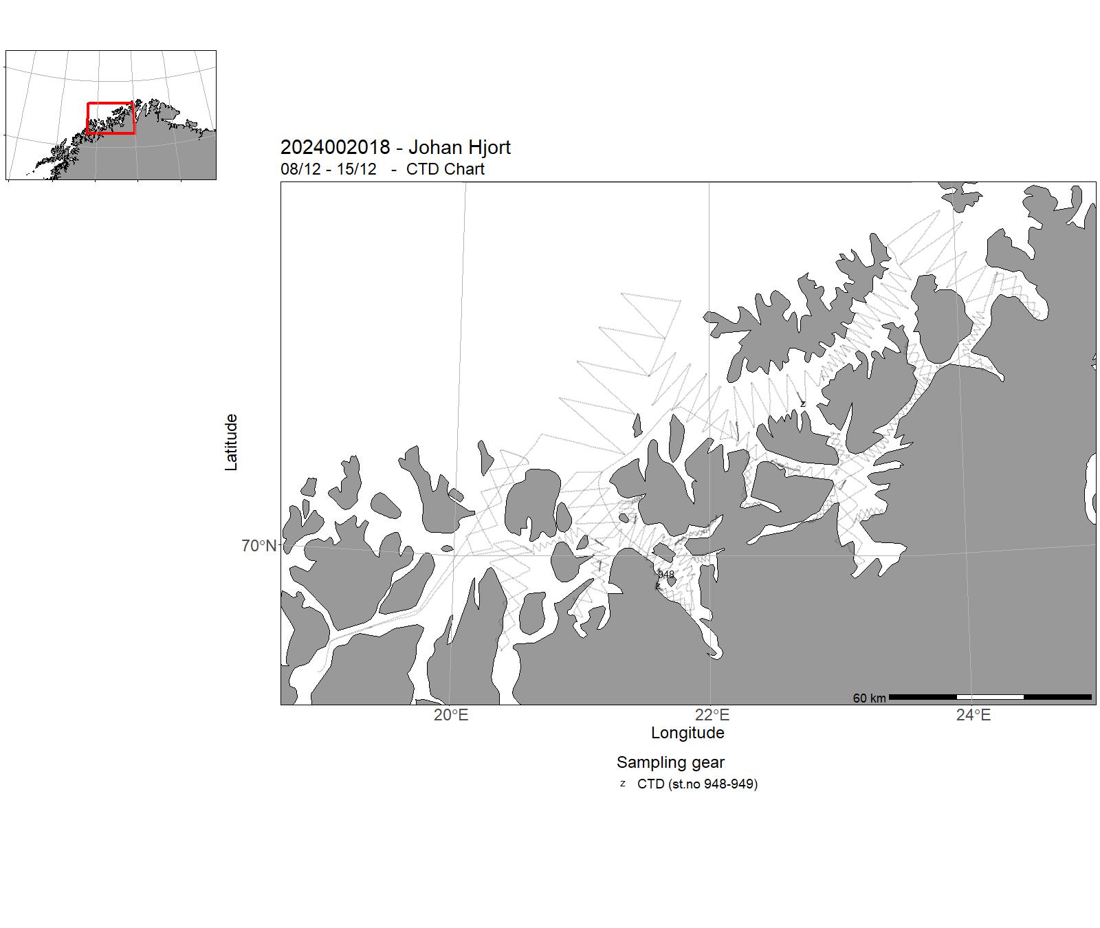
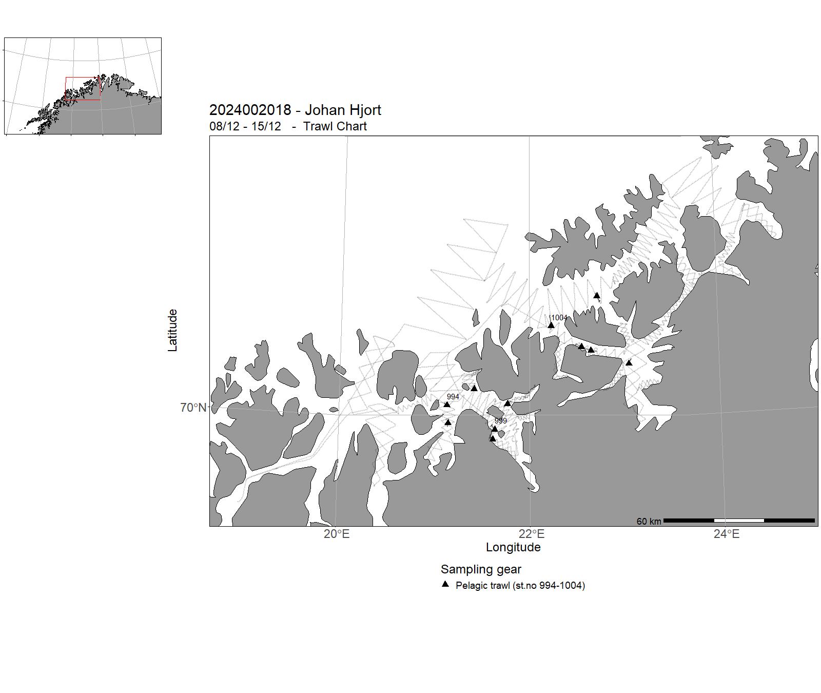
| 2024002018 | 08/12 - 15/12 | Measuring the abundance, distribution and age composition of Norwegian Spring Spawning Herring, Pelagic trawls, Echo sounder sampling, Mapping of hydrographical conditions | Norwegian Sea | 948-949 | 994-1004 |
5 - “Johan Hjort” – Charts for cruises 2024


6 - "Kronprins Haakon" – Cruises 2024
| Cruise no | Period | Purpose | Area | CTD st.no | Trawl st.no |
| 2024007001 | 07/01 - 13/01 | I tidsrommet 2018-2021 har FG Fangst i samarbeid med Rederiavdelingen gjennomført et årlig «Metode- og redskapstokt» i slutten av året. Relevante problemstillinger for metode- og redskapstokt i 2024 inkluderer: Dokumentere prosedyre for tråling under isen. Teste prosedyre utviklet av H. Johansen, kaptein KPH, og skrive trålmanual for bruk av Harstadtrål under isen. | Barents Sea | - | - |
| 2024007002 | 11/01 - 10/02 | Wintersuvey in the Barents Sea. Main focus is distribution of cod and haddock. Project name: Vintertoktet | Greenland Sea | 1-62 | 1 - 146 |
| 2024007003 | 07/03 - 20/03 | Mareano collects and disseminates knowledge about the environment and natural values on the seabed. Since 2005, the Norwegian Mapping Authority (Kartverket), the Geological Survey of Norway (NGU), and the Institute of Marine Research (HI) have collaborated on mapping, advising, and providing essential knowledge for our marine management plans. This request pertains to vessel time for the collection of water and bottom samples to gain new insights into biological diversity, species distribution, environmental chemistry, and seabed sediments in marine areas prioritized at the departmental level. The North Sea is a prioritized area in 2023, and Leg 3 completed planned and prioritized areas using ROV and Munin+ AUV. | North Sea | 67-75 | 1-6 |
| 2024007004 | 31/03 - 07/04 | LoVe - Lofoten Vesterålen cabled observatory. Ocean observatory monitoring, NFR infrastructure project | Norskehavet | 77-80 | - |
| 2024007005 | 10/04 - 30/04 | Mareano collects and disseminates knowledge about the environment and natural values on the seabed. Since 2005, the Norwegian Mapping Authority (Kartverket), the Geological Survey of Norway (NGU), and the Institute of Marine Research (HI) have collaborated on mapping, advising, and providing essential knowledge for our marine management plans. This request pertains to vessel time for the collection of water and bottom samples to gain new insights into biological diversity, species distribution, environmental chemistry, and seabed sediments in marine areas Spitsbergenbanken, Hopendjupet og Kvitøyrenna. | Barents Sea | 81-86 | 7-10 |
| 2024007007 | 02/05 - 04/06 | During the first leg, the expedition involved three main partners, The Nippon Foundation-Nekton Ocean Census project, the UiT The Arctic University of Norway and REV Ocean. The expedition focused on sampling the deep-sea fauna of the Knipovich Ridge, the northernmost part of the Mid-Atlantic Ridge. Multiple habitats were sampled along the ridge, including sediments, and rocky habitats. In the second leg, the expedition focused on cold seep sites characterised by methane emissions in several localities in the Barents Sea. The expedition has been developed by leveraging the extensive knowledge gained from two significant projects funded by the Norwegian Research Council: CAGE (Centre for Arctic Gas Hydrate, Environment and Climate) and AKMA (Advancing Knowledge of Methane in the Arctic), both hosted at the Department of Geosciences at UiT. Project name: EXTREME24-Ocean Census | Norwegian Sea | 87-109 | - |
| 2024007008 | 13/10 - 26/10 | Resilient northern overturning in a warming climate (ROVER) is a project that aims to determine how resilient the overturning in the Nordic Seas is to climate change, with particular focus on the impact of reduced sea-ice extent. The hypothesis is that as the sea ice recedes, increasing stretches of the boundary current system around the Nordic Seas and Arctic Ocean become exposed to the atmosphere. The resulting increased ocean heat loss in winter further densifies the water in the boundary current, which is a direct pathway supplying the lower limb of the overturning circulation. Project name: Resilient northern overturning in a warming climate (ROVER) | Greenland Sea | 327-376 | - |
| 2024007009 | 14/07 - 12/08 | Our first priority is to recover two deep water moorings from the Nansen and Amundsen Basins in the Central Arctic Ocean that were deployed in August 2022. More than 20 different instruments attached to these moorings contain valuable time series measurements, as well as water and sediment samples. After recovery, we plan to redeploy the moorings at the same sites for another 2-year period (2024-2026). Our second priority is to repeat a section of hydrographic, biological and biogeochemical measurements across the Nansen and Amundsen Basins. T | Polhavet | 110-178 | 1-3 |
| 2024007010 | 13/08 - 28/08 | Annual service and monitoring at the Fram Strait Arctic Outflow Observatory from the Norwegian Polar Institute.The annual service encompasses the service of 7 ocean moorings measuring the freshwater and sea ice transport in the Fram Strait since 1997/1990 resp. In addition, a hydrographic section is undertaken at 78°50'N from 10°E to 14°W, and if ice conditions allow, this is continued further onto the shelf toward Greenland across the Norske Trough.The CTD section includes water sampling of 11 parameters to quantify freshwater tracers, biogeochemistry and ocean acidification, and current mapping by VMADCP and LADCP. Underway sea ice stations are carried out on the drift ice in the ice covered parts of the section and on land-fast ice on the Belgica bank to obtain ice cores for thickness and chemistry and ice ridging. Project name: Fram Strait Arctic Outflow Observatory | Greenland Sea | 179-251 | - |
| 2024007011 | 29/08 - 19/09 | The aim of this third GoNorth cruise was to do science that addresses the passive, extensional continental margin, the ultra-slow spreading ridge, past climate, glacial and oceanographic development in the Arctic, as well as investigations of sea ice properties. At least 13 research projects will benefit from the data. Project name: GoNorth (https://gonortharctic.no) | Greenland Sea | 252 - 282 | - |
| 2024007012 | 22/09 - 12/10 | The aim of the cruise is to monitor the status and changes in the ecosystem and obtain the necessary data for advice and research. Arctic part of the BESS collects data and reports more than 50 time series to Norwegian-Russian fisheries and environment commissions, and to several ICES groups. Project name: Økotoktet - Økosystemtokt i Barentshavet | Barents Sea | 283-326 | 1 - 93 |
| 2024007014 | 28/10 - 12/11 | The data was collected as part of the UiT based SEAMSTRESS project which aims at quantifying the effect of tectonic and glacial stress on seefloor seepage at Arctic continental margins. The cruise main objective was to collect cone penetration tool data (CPT) from Arctic sediments to investigate the role of sub-seabed methane and gas hydrates on slope instability. Project name: FAHYS | Greenland Sea | 377-379 | - |
| 2024007015 | 08/11 - 22/11 | Rig service northeast and east of Svalbard. Data collection and sampling from the ship. | Svalbard | - | - |
| 2024007016 | 26/11 - 14/12 | During the last operative days of the GoNorth-2023 expedition, we discovered a large hydrothermal field in the Fram Strait. The vent field named Ultima Thule - has several characteristics that make it unique. The proposed expedition will be a necessary follow-up to the discovery, with the objectives of carrying out a comprehensive mapping and sampling of the vent field and the surrounding area. This will lay the groundwork for a range of new scientific studies and for the deployment of instrumentation for long-term monitoring of the vent field and its surroundings. | Iceland/Greenland | - | - |
| 2024007017 | 14/02 - 02/03 | This research cruise was a collaboration between the Norwegian Offshore Directorate (NOD) and the Center for Deep Sea Research at the University of Bergen (UiB). The main objective of the cruise was to investigate off-axis areas northwest of the central Mohns Ridge, advancing our understanding of the geology and marine mineral potential in these regions. | Norwegian Sea | 63-66 | - |
| 2024007018 | 12/11 - 22/11 | The ultra-slow Knipovich Ridge in the northern North Atlantic is one of the least explored mid-ocean ridge segments along the mid-Atlantic ridge system. This project plans to acquire heat flow data at a number of transects across Knipovich Ridge. The heat flow data will be used in heat transport modelling to determine the thermal state of the crust and its variation along the ridge axis. | Atlanterhavet NØ | 380-381 | - |
7 - “ Kronprins Haakon” – Charts for cruises 2024


8 - "G. M. Dannevig" – Cruises 2024
| Cruise no | Period | Purpose | Area | CTD st.no | Trawl st.no |
| 2024003001 | 07/01 - 14/01 | Monitoring of chemical, physical and biological conditions in the Skagerrak and fjords on the Skagerrak. Data are necessary in connection with environmental status assessments and ocean acidification for the coast and sea area of the Skagerrak and central in the follow-up of the management plan for the Oslofjord. The activity provides a data source for a number of projects in the area, as well as contributing data to HAB research and monitoring under the auspices of HI. The activity maintains several long time series of physical, chemical and biological parameters in the Skagerrak, essential for uncovering climate, acidification and eutrophication challenges. | Skagerrak | 0001 - 0032 | - |
| 2024003002 | 05/02 - 11/02 | Monitoring of chemical, physical and biological conditions in the Skagerrak and fjords on the Skagerrak. Data are necessary in connection with environmental status assessments and ocean acidification for the coast and sea area of the Skagerrak and central in the follow-up of the management plan for the Oslofjord. External project (Mdir) depends on data capture within this activity. The activity provides a data source for a number of projects in the area, as well as contributing data into HAB research and monitoring under the auspices of HI. The activity maintains several long time series within physical, chemical and biological parameters in the Skagerrak, essential for uncovering climate, acidification and eutrophication challenges. | Skagerrak | 0033 - 0063 | - |
| 2024003003 | 03/03 - 08/03 | Monitoring of chemical, physical and biological conditions in the Skagerrak and fjords on the Skagerrak. Data are necessary in connection with environmental status assessments and ocean acidification for the coast and sea area of the Skagerrak and central in the follow-up of the management plan for the Oslofjord. External project (Mdir) depends on data capture within this activity. The activity provides a data source for a number of projects in the area, as well as contributing data into HAB research and monitoring under the auspices of HI. The activity maintains several long time series within physical, chemical and biological parameters in the Skagerrak, essential for uncovering climate, acidification and eutrophication challenges. | Skagerrak | 0064 - 0093 | - |
| 2024003004 | 14/03 - 25/03 | The expedition will map and monitor spawning grounds for coastal stocks of cod, haddock, pollack, saithe and whiting through egg collection. The expedition is the primary data source for the delivery of spawning ground maps for land management in the coastal zone. | North Sea | - | - |
| 2024003005 | 26/03 - 03/04 | Mapping and monitoring of sandeel in Western Norway and Møre. | North Sea | 0094 - 0115 | 1-48 |
| 2024003006 | 09/04 - 13/04 | Monitoring of chemical, physical and biological conditions in the Skagerrak and fjords on the Skagerrak. Data are necessary in connection with environmental status assessments and ocean acidification for the coast and sea area of the Skagerrak and central in the follow-up of the management plan for the Oslofjord. External project (Mdir) depends on data capture within this activity. The activity provides a data source for a number of projects in the area, as well as contributing data into HAB research and monitoring under the auspices of HI. The activity maintains several long time series within physical, chemical and biological parameters in the Skagerrak, essential for uncovering climate, acidification and eutrophication challenges. | Skagerrak | 0116 - 0135 | - |
| 2024003007 | 01/05 - 07/05 | Environmental monitoring. | North Sea | 0136 - 0161 | - |
| 2024003008 | 10/05 - 04/06 | Post-smolt trawling. Salmon lice monitoring. | Norwegian Sea | - | - |
| 2024003009 | 26/06 - 05/07 | Monitoring of chemical, physical and biological conditions in the Skagerrak and fjords on the Skagerrak. Data are necessary in connection with environmental status assessments and ocean acidification for the coast and sea area of the Skagerrak and central in the follow-up of the management plan for the Oslofjord. External project (Mdir) depends on data capture within this activity. The activity provides a data source for a number of projects in the area, as well as contributing data into HAB research and monitoring under the auspices of HI. The activity maintains several long time series within physical, chemical and biological parameters in the Skagerrak, essential for uncovering climate, acidification and eutrophication challenges. | Skagerrak | - | - |
| 2024003010 | 11/07 - 20/07 | Monitoring of chemical, physical and biological conditions in the Skagerrak and fjords on the Skagerrak. Data are necessary in connection with environmental status assessments and ocean acidification for the coast and sea area of the Skagerrak and central in the follow-up of the management plan for the Oslofjord. External project (Mdir) depends on data capture within this activity. The activity provides a data source for a number of projects in the area, as well as contributing data into HAB research and monitoring under the auspices of HI. The activity maintains several long time series within physical, chemical and biological parameters in the Skagerrak, essential for uncovering climate, acidification and eutrophication challenges. | Skagerrak | 0162 - 0192 | - |
| 2024003011 | 06/08 - 11/08 | Monitoring of chemical, physical and biological conditions in the Skagerrak and fjords on the Skagerrak. Data are necessary in connection with environmental status assessments and ocean acidification for the coast and sea area of the Skagerrak and central in the follow-up of the management plan for the Oslofjord. External project (Mdir) depends on data capture within this activity. The activity provides a data source for a number of projects in the area, as well as contributing data into HAB research and monitoring under the auspices of HI. The activity maintains several long time series within physical, chemical and biological parameters in the Skagerrak, essential for uncovering climate, acidification and eutrophication challenges. | Skagerrak | 0193 - 0219 | - |
| 2024003012 | 12/08 - 19/08 | Monitoring of populations and development within and outside lobster reserves at Bolærne (Færder National Park) and Kvernskjær (Ytre Hvaler National Park). | North Sea | - | - |
| 2024003013 | 21/08 - 23/08 | Student cruise, UiA BIO413, Benthic ecology. | North Sea | - | - |
| 2024003014 | 13/09 - 14/09 | Monitoring of chemical, physical and biological conditions in the Skagerrak and fjords on the Skagerrak. Data are necessary in connection with environmental status assessments and ocean acidification for the coast and sea area of the Skagerrak and central in the follow-up of the management plan for the Oslofjord. External project (Mdir) depends on data capture within this activity. The activity provides a data source for a number of projects in the area, as well as contributing data into HAB research and monitoring under the auspices of HI. The activity maintains several long time series within physical, chemical and biological parameters in the Skagerrak, essential for uncovering climate, acidification and eutrophication challenges. | Skagerrak | 0220 - 0231 | - |
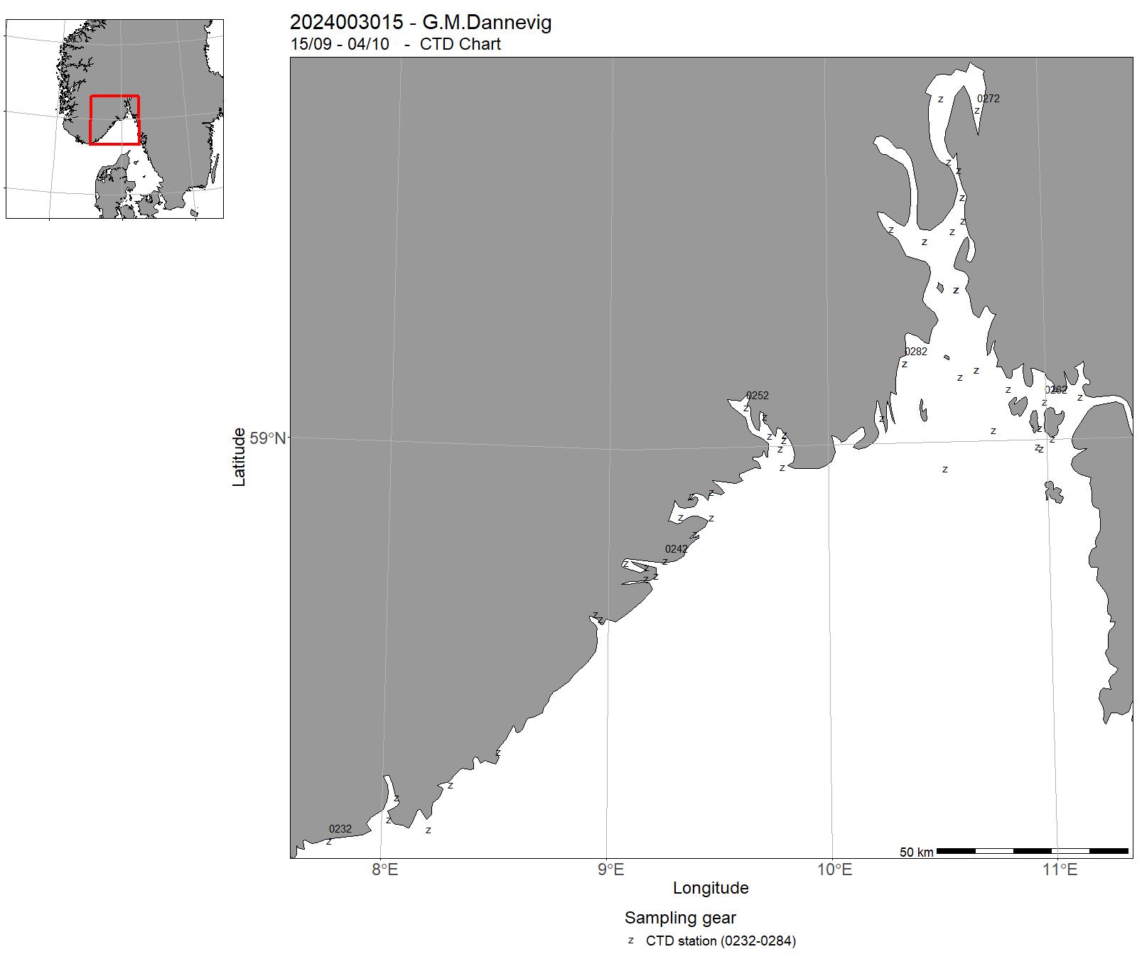
| 2024003015 | 15/09 - 04/10 | Beach seine survey. | Skagerrak | 0232 - 0284 | - |
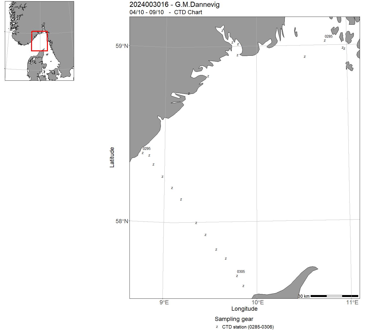
| 2024003016 | 04/10 - 09/10 | Monitoring of chemical, physical and biological conditions in the Skagerrak and fjords on the Skagerrak. Data are necessary in connection with environmental status assessments and ocean acidification for the coast and sea area of the Skagerrak and central in the follow-up of the management plan for the Oslofjord. External project (Mdir) depends on data capture within this activity. The activity provides a data source for a number of projects in the area, as well as contributing data into HAB research and monitoring under the auspices of HI. The activity maintains several long time series within physical, chemical and biological parameters in the Skagerrak, essential for uncovering climate, acidification and eutrophication challenges. | Skagerrak | 0285 - 0306 | - |
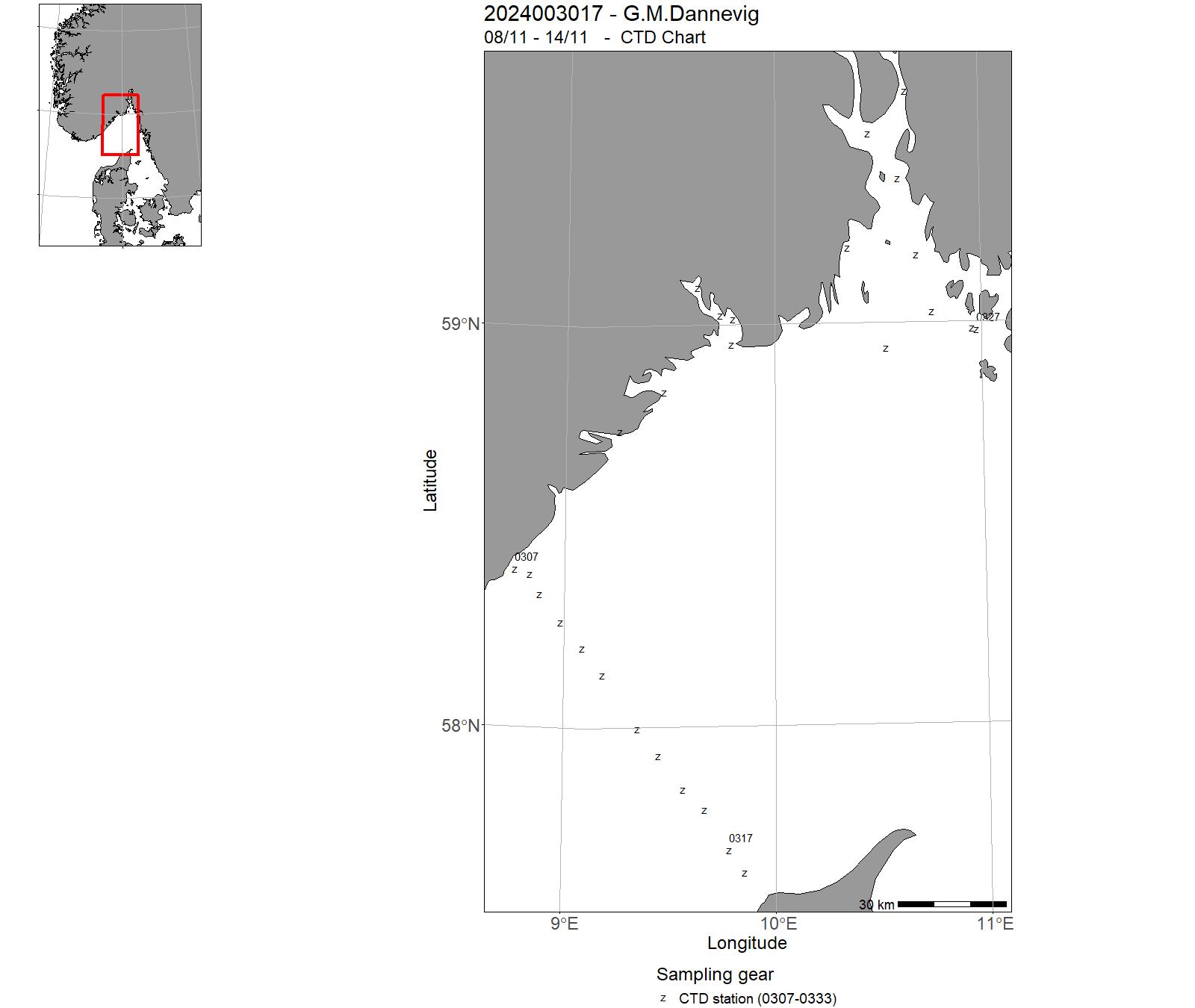
| 2024003017 | 08/11 - 14/11 | Monitoring of chemical, physical and biological conditions in the Skagerrak and fjords on the Skagerrak. Data are necessary in connection with environmental status assessments and ocean acidification for the coast and sea area of the Skagerrak and central in the follow-up of the management plan for the Oslofjord. External project (Mdir) depends on data capture within this activity. The activity provides a data source for a number of projects in the area, as well as contributing data into HAB research and monitoring under the auspices of HI. The activity maintains several long time series within physical, chemical and biological parameters in the Skagerrak, essential for uncovering climate, acidification and eutrophication challenges. | Skagerrak | 0307 - 0333 | - |
| 2024003018 | 15/11 - 01/12 | Winter fishing ('Vinterfiske') is a time series focusing on monitoring coastal cod (using gillnets, trolling nets) that started in the 1980s, had a hiatus in the 1990s and started again in the 2000s, and now has over 30 years of data. It is the only monitoring activity on coastal adult cod in the Skagerrak. Since the 2000s, all other species have also been measured, weighed and registered. Trolling nets cover a fairly wide range of sizes, and thus provide an overview of what kind of fish are out there, as well as trends over time. | Skagerrak | - | - |
| 2024003019 | 02/12 - 09/12 | Monitoring of chemical, physical and biological conditions in the Skagerrak and fjords on the Skagerrak. Data are necessary in connection with environmental status assessments and ocean acidification for the coast and sea area of the Skagerrak and central in the follow-up of the management plan for the Oslofjord. External project (Mdir) depends on data capture within this activity. The activity provides a data source for a number of projects in the area, as well as contributing data into HAB research and monitoring under the auspices of HI. The activity maintains several long time series within physical, chemical and biological parameters in the Skagerrak, essential for uncovering climate, acidification and eutrophication challenges. | Skagerrak | - | - |
| 2024003020 | 30/07 - 05/08 | Årlig Miljøovervåking av hardbunn i programmet "Økokyst" på oppdrag fra Miljødirektoratet for rapportering etter vannforskriften. | Norwegian Coast: Sør- og Østlandet | - | - |
9 - "G. M. Dannevig" – Charts for cruises 2024


10 - "Dr. Fridtjof Nansen" – Cruises 2024
| Cruise no | Period | Purpose | Area | CTD st.no | Trawl st.no |
| 2024004001 | 26/01 - 27/02 | The main objective of the cruise leg 1.1 was to assess demersal fisheries ressources in Northwest Africa. Other aspects were also addressed to improve knowledge on composition and diversity of demersal communities, epi- and endobenthos, stock identity and parasite identification of fish, zooplankton and ichthyoplankton biomass and composition, the ecotoxicological and chemical characterization of sea water, fish species and sediment samples as well as the physical and chemical environmental conditions. Project name: Strengthening the Knowledge Base for and Implementing an Ecosystem Approach to Marine Fisheries in Developing Countries | Atlantic Ocean | 1 - 198 | 1-118 |
| 2024004002 | 02/03 - 15/03 | Assessment of fisheries resources was a key priority for Leg 1.2. However, other aspects were also addressed to improve knowledge on composition and diversity of demersal communities, epi- and endobenthos, stock identity and parasite identification of fish, zooplankton and ichthyoplankton biomass and composition, the ecotoxicological and chemical characterization of sea water, fish species and sediment samples as well as the physical and chemical environmental conditions. Project name: Strengthening the Knowledge Base for and Implementing an Ecosystem Approach to Marine Fisheries in Developing Countries | Atlantic Ocean | 199 - 285 | 119-179 |
| 2024004003 | 17/03 - 27/03 | The survey objectives were : Obtain information on abundance, taxonomic composition, and distribution of demersal fisheries resources of the shelf and on the upper slope to a depth of approximately 800 m. Project name: Strengthening the Knowledge Base for and Implementing an Ecosystem Approach to Marine Fisheries in Developing Countries | Atlantic Ocean | 286 - 364 | 180-235 |
| 2024004004 | 04/04 - 04/05 | Transboundary demersal survey following a standard setup for demersal surveys for DFN (survey design, equipment, data collection and biological sampling). | Vest-Afrika | 365 - 556 | 236 - 400 |
| 2024004005 | 09/05 - 05/06 | The survey objectives were: The general objectives of the surveys of Leg 2.2 are the following (in a prioritized order):1. To obtain information on demersal and pelagic living marine resources (biomass, diversity, distribution and demographics).2. To obtain information on standard biological parameters of priority species (including length, weight, sex and maturity).3. To collect marine taxa for species identification and genetic analyses.4. To obtain information on physical and chemical properties in the water column (temperature, salinity, dissolved O~2~, chlorophyll, pH, alkalinity, nutrients, light penetration, and water currents).5. To extend the measurement of environmental variables at two environmental "master transects".6. To obtain information on mesozooplankton and ichthyoplankton biomass, diversity and distribution.7. To obtain information on the presence of marine litter (caught during trawl hauls). Project name: Strengthening the Knowledge Base for and Implementing an Ecosystem Approach to Marine Fisheries in Developing Countries | Atlantic Ocean | 557 - 725 | 401 - 524 |
| 2024004006 | 21/06 - 30/07 | Part 1 The general objectives: Obtain information on key pelagic fish species abundance, their distribution and size structure, as well as the species composition of the pelagic fish assemblage. Part 2 The general objectives: Obtain horizontal and vertically stratified egg and larval distribution and abundance patterns: Obtain occurrences in relation to the biotic and physical environment. Project name: Strengthening the Knowledge Base for and Implementing an Ecosystem Approach to Marine Fisheries in Developing Countries | Atlantic Ocean | 726 - 918 | 547 - 637 |
| 2024004007 | 02/08 - 02/09 | The general objectives: Obtain information on key pelagic fish species abundance, their distribution and size structure, as well as the species composition of the pelagic fish assemblage. Project name: Strengthening the Knowledge Base for and Implementing an Ecosystem Approach to Marine Fisheries in Developing Countries | Atlantic Ocean | 919 - 1044 | 638 - 715 |
| 2024004008 | 06/09 - 24/09 | The general objectives: Obtain catch (weight and number) information of all demersal species Use weight and number information of selected demersal fish, crustacean, and cephalopod species for swept area abundance estimation using StoX. Project name: Strengthening the Knowledge Base for and Implementing an Ecosystem Approach to Marine Fisheries in Developing Countries | Atlantic Ocean | 1045 - 1142 | 716-819 |
| 2024004009 | 30/09 - 23/10 | This survey encompasses two studies with two different scientific objectives. The objective of the first study is to document benthic habitats, with a particular focus on VME (Vulnerable Marine Ecosystems) indicator species and habitats, centered around the continental shelf between Walvis Bay and Lüderitz, to support the upcoming MSC audit of the hake fisheries. The objective of the second study is to perform a baseline study (also this with focus on VME indicator species) in the phosphate mining license area of Industrial Minerals, 75 nm southwest of Walvis Bay. Project name: EAF-Nansen Programme | Southeast Atlantic Ocean (20W) | 1143-1171 | 1-98 |
| 2024004010 | 25/10 - 19/11 | Leg 4 was a regional transboundary survey that covered the demersal fisheries resources of Namibia and Angola from 20 to 800 m. Leg 4.3 was the last part of this transboundary survey. The main objective was to survey fishery resources in Angolan waters. Other components of the ecosystem were also monitored to enhance the understanding of factors driving the abundance and distribution of demersal resources and contribute to knowledge in relation to habitats and climatic impacts. Project name: Strengthening the Knowledge Base for and Implementing an Ecosystem Approach to Marine Fisheries in Developing Countries | Atlantic Ocean | 1172 - 1377 | 820-978 |
| 2024004011 | 08/06 - 11/06 | To investigate the effect of Ghanaian commercial trawl gear cod end circumference on catchability, with 85 (recommended) and 170 (regulated) meshes in circumference. Project name: The EAF Nansen program in partnership with The fish for development program in Ghana. | Atlantic Ocean | - | 525-546 |
11 - "Dr. Fridtjof Nansen" Charts for 2024


12 - "Hans Brattstrøm" Cruises 2024
| Cruise no | Period | Purpose | Area | CTD st.no | Trawl st.no |
| 2024009001 | 15/01 - 15/01 | Innsamling av dyreplankton (Appendicularia ) til kultivering i forskningsøyemed. | Norwegian Coast: Vestlandet | - | - |
| 2024009002 | 16/01 - 16/01 | Undersøke hvordan havforsuring varierer over tid i fjorder sør for Bergen Vi ønsker å forlenge tidsserier av havforsuringsmålinger i Korsfjorden og Hardangerfjorden. Tidsseriene ble starta i 2007. I 2023 vil vi ta vannprøver annenhver måned fra disse to stasjonene. Dette bidrar til prosjektet "Overvåking av havforsuring 2021-2025" i regi av Miljødirektoratet. | Norwegian Coast: Vestlandet | - | - |
| 2024009003 | 18/01 - 18/01 | Collecting Ctenophores in fjords for our research and establishing new Ctenophores species cultures in our animal facility. | Norwegian Coast: Vestlandet | - | - |
| 2024009004 | 22/01 - 26/01 | Toktet støtter overvåkningstidsserier for lakselus og miljøvirkninger av akvakultur. Dataene er sentrale i bruken og utviklingen av strømmodellsystemene NorKyst og NorFjords. Dataene som samles inn er hydrografi og strøm (fra strømmålerrigger) og bygger på aktivitet som har pågått i 20 år. Toktet er del av en serie med ca. månedlige tokt i området. | Norwegian Coast: Vestlandet | - | - |
| 2024009005 | 29/01 - 02/02 | Kopper blir i hovedsak brukt som antibegroingsmiddel på nøter ved marine matfiskanlegg, og estimat på bruk av kopper i norsk fiskeoppdrett viser at oppdrettsnæringa er den største bidragsyteren til utslipp av kopper i Norge. Den økte veksten i næringa har også medført en økning i mengde utslipp av kopper, og det er estimert at det årlige utslippet fra næringa er mer enn 1000 tonn. Måling av kopper i sediment på bunnen ved oppdrettslokaliteter i Hordaland har vist at det kan forekomme relativt høye konsentrasjoner under enkelte anlegg. Det er et behov for økt kunnskap om effektene av bruk av kopper ved akvakulturproduksjon. Materiale: Starta overvåkingsserie av Cu og andre fremmedstoff i sediment i utfellingsområder i Hordaland som kan bli påvirket av utslipp fra akvakulturanlegg. Ca 20 stasjoner ble prøvetatt i årlig i periodenn2018-2023 (inkludert stasjoner fra Blue planet overvåkingen). Mål: å skaffe kunnskap som kan gi bedre grunnlag for risikovurdering av utlekking av Cu og Zn fra akvakulturanlegg. | Norwegian Coast: Vestlandet | - | - |
| 2024009006 | 05/02 - 05/02 | Innsamling av dyreplankton (Appendicularia ) til kultivering i forskningsøyemed. | Norwegian Coast: Vestlandet | - | - |
| 2024009007 | 06/02 - 09/02 | Students will get training in oceanographic work - moorings, CTD, and water sampling. If possible we might also use microstructrure profiling. | Atlanterhavet S | - | - |
| 2024009008 | 10/02 - 13/02 | Opplæring av personell i å operere USV Sounder | Norwegian Coast: Vestlandet | - | - |
| 2024009009 | 14/02 - 15/02 | SFI Smart Ocean er et 8 årig prosjekt (NFR, ledet av UiB). HI skal i denne perioden bygge opp og drifte testfasiliteter på og rundt Austevoll havbruksstasjon. Partnere skal kunnes sette ut sensorer og sensorhuber for uttesting, samt referansesystem. Det trengs et mellomstort fartøy med kran- og vinsjkapasitet for utsetting av rigger og landere, samt ta CTD og vannprøver. Fartøystilgang er en lovnad i prosjektet. Prosjektet er fleksible på når toktene kan gå, men helst spredd noenlunde jevnt utover året. Det er gitt forpliktelser til å stille med fartøy i prosjektet, men ikke i hvilket omfang. Samtidig er det viktig å komme i gang med å få utstyr i vannet ved Austevoll. Dette er også i samarbeid med SFI CRIMAC. 4 sånne tokt har skjedd i 2022. 4 skal skje i 2023. Med de 2024 toktene skal vi fortsette hva vi har startet i 2022. Aktiviteter: Utsetting av utstyr, innhenting av utstyr, kartlegging av hydrografi, akustikk og havkjemi | Norwegian Coast: Vestlandet | - | - |
| 2024009010 | 16/02 - 16/02 | To survey the hidden diversity of parasitic crustaceans in Norwegian fjord habitats, fjord systems in the vicinity of Bergen will be used as the study area. With a focus on Copepoda, Thecostraca and Isopoda, classical marine biological collection methods, complemented with molecular methods (ddPCR), will be employed in the search for rare and overlooked species. During the project period selected habitats will be repeteatedly visited to follow the fluctuation of the parasite fauna over a season. The project is partly financed by the Norwegian Biodiversity Information Centre: UiB project # 102843103 | Norwegian Coast: Vestlandet | - | - |
| 2024009011 | 19/02 - 23/02 | Toktet støtter overvåkningstidsserier for lakselus og miljøvirkninger av akvakultur. Dataene er sentrale i bruken og utviklingen av strømmodellsystemene NorKyst og NorFjords. Dataene som samles inn er hydrografi og strøm (fra strømmålerrigger) og bygger på aktivitet som har pågått i 20 år. Toktet er del av en serie med ca. månedlige tokt i området. | Norwegian Coast: Vestlandet | - | - |
| 2024009012 | 26/02 - 26/02 | Collecting Ctenophores in fjords for our research and establishing new Ctenophores species cultures in our animal facility. | Norwegian Coast: Vestlandet | - | - |
| 2024009013 | 27/02 - 01/03 | Tokt for å eksponere gytende torsk til kontinuerlig lyd. Tilsvarende tokt har vært gjennomført i juni 2023. Formål å undersøke forskjeller i torskens adferd i gytefase og beitefase. | Atlanterhavet NØ | - | - |
| 2024009014 | 04/03 - 04/03 | Innsamling av dyreplankton (Appendicularia ) til kultivering i forskningsøyemed. | Norwegian Coast: Vestlandet | - | - |
| 2024009015 | 05/03 - 08/03 | Students will get training in oceanographic work - moorings, CTD, and water sampling. If possible we might also use microstructrure profiling. | Atlanterhavet S | - | - |
| 2024009016 | 11/03 - 14/03 | Students in the courses GEOF232 will get training in oceanographic fieldwork and collect data for their semester projects. | Norwegian Coast: Vestlandet | - | - |
| 2024009017 | 15/03 - 15/03 | To survey the hidden diversity of parasitic crustaceans in Norwegian fjord habitats, fjord systems in the vicinity of Bergen will be used as the study area. With a focus on Copepoda, Thecostraca and Isopoda, classical marine biological collection methods, complemented with molecular methods (ddPCR), will be employed in the search for rare and overlooked species. During the project period selected habitats will be repeteatedly visited to follow the fluctuation of the parasite fauna over a season. The project is partly financed by the Norwegian Biodiversity Information Centre: UiB project # 102843103 | Norwegian Coast: Vestlandet | - | - |
| 2024009018 | 18/03 - 21/03 | Toktet støtter overvåkningstidsserier for lakselus og miljøvirkninger av akvakultur. Dataene er sentrale i bruken og utviklingen av strømmodellsystemene NorKyst og NorFjords. Dataene som samles inn er hydrografi og strøm (fra strømmålerrigger) og bygger på aktivitet som har pågått i 20 år. Toktet er del av en serie med ca. månedlige tokt i området. | Norwegian Coast: Vestlandet | - | - |
| 2024009019 | 22/03 - 22/03 | Collecting Ctenophores in fjords for our research and establishing new Ctenophores species cultures in our animal facility. | Norwegian Coast: Vestlandet | - | - |
| 2024009020 | 02/04 - 02/04 | Undersøke hvordan havforsuring varierer over tid i fjorder sør for Bergen Vi ønsker å forlenge tidsserier av havforsuringsmålinger i Korsfjorden og Hardangerfjorden. Tidsseriene ble starta i 2007. I 2024 vil vi ta vannprøver annenhver måned fra disse to stasjonene. Dette bidrar til prosjektet "Overvåking av havforsuring 2021-2025" i regi av Miljødirektoratet. | Norwegian Coast: Vestlandet | - | - |
| 2024009021 | 03/04 - 04/04 | Mooring deployment & CTD at Sognesjøen (+ CTD in Masfjorden & Lurefjorden if time) | Atlanterhavet S | - | - |
| 2024009022 | 23/04 - 23/04 | Innsamling av dyreplankton (Appendicularia ) til kultivering i forskningsøyemed. | Norwegian Coast: Vestlandet | - | - |
| 2024009023 | 24/04 - 24/04 | To survey the hidden diversity of parasitic crustaceans in Norwegian fjord habitats, fjord systems in the vicinity of Bergen will be used as the study area. With a focus on Copepoda, Thecostraca and Isopoda, classical marine biological collection methods, complemented with molecular methods (ddPCR), will be employed in the search for rare and overlooked species. During the project period selected habitats will be repeteatedly visited to follow the fluctuation of the parasite fauna over a season. The project is partly financed by the Norwegian Biodiversity Information Centre: UiB project # 102843103 | Norwegian Coast: Vestlandet | - | - |
| 2024009024 | 25/04 - 25/04 | Collecting Ctenophores in fjords for our research and establishing new Ctenophores species cultures in our animal facility. | Norwegian Coast: Vestlandet | - | - |
| 2024009025 | 26/04 - 29/04 | Toktet støtter overvåkningstidsserier for lakselus og miljøvirkninger av akvakultur. Dataene er sentrale i bruken og utviklingen av strømmodellsystemene NorKyst og NorFjords. Dataene som samles inn er hydrografi og strøm (fra strømmålerrigger) og bygger på aktivitet som har pågått i 20 år. Toktet er del av en serie med ca. månedlige tokt i området. | Norwegian Coast: Vestlandet | - | - |
| 2024009026 | 30/04 - 03/05 | Årleg obligatorisk feltkurs i Modul 1 (Fauna) i kurset BIO325 - Havforsking | Norwegian Coast: Vestlandet | - | - |
| 2024009027 | 06/05 - 09/05 | Årleg obligatorisk feltkurs i Modul 1 (Fauna) i kurset BIO325 - Havforsking | Norwegian Coast: Vestlandet | - | - |
| 2024009029 | 15/05 - 16/05 | SFI Smart Ocean er et 8 årig prosjekt (NFR, ledet av UiB). HI skal i denne perioden bygge opp og drifte testfasiliteter på og rundt Austevoll havbruksstasjon. Partnere skal kunnes sette ut sensorer og sensorhuber for uttesting, samt referansesystem. Det trengs et mellomstort fartøy med kran- og vinsjkapasitet for utsetting av rigger og landere, samt ta CTD og vannprøver. Fartøystilgang er en lovnad i prosjektet. Prosjektet er fleksible på når toktene kan gå, men helst spredd noenlunde jevnt utover året. Det er gitt forpliktelser til å stille med fartøy i prosjektet, men ikke i hvilket omfang. Samtidig er det viktig å komme i gang med å få utstyr i vannet ved Austevoll. Dette er også i samarbeid med SFI CRIMAC. 4 sånne tokt har skjedd i 2022. 4 skal skje i 2023. Med de 2024 toktene skal vi fortsette hva vi har startet i 2022. Aktiviteter: Utsetting av utstyr, innhenting av utstyr, kartlegging av hydrografi, akustikk og havkjemi | Norwegian Coast: Vestlandet | - | - |
| 2024009030 | 24/05 - 24/05 | 2024-BIO-791: Innsamling av dyreplankton (Appendicularia ) til kultivering i forskningsøyemed. | Norwegian Coast: Vestlandet | - | - |
| 2024009031 | 22/05 - 22/05 | 2024-BIO-816: To survey the hidden diversity of parasitic crustaceans in Norwegian fjord habitats, fjord systems in the vicinity of Bergen will be used as the study area. With a focus on Copepoda, Thecostraca and Isopoda, classical marine biological collection methods, complemented with molecular methods (ddPCR), will be employed in the search for rare and overlooked species. During the project period selected habitats will be repeteatedly visited to follow the fluctuation of the parasite fauna over a season. The project is partly financed by the Norwegian Biodiversity Information Centre: UiB project # 102843103 | Norwegian Coast: Vestlandet | - | - |
| 2024009032 | 23/05 - 23/05 | Collecting Ctenophores in fjords for our research and establishing new Ctenophores species cultures in our animal facility. | Norwegian Coast: Vestlandet | - | - |
| 2024009033 | 21/05 - 21/05 | Undersøke hvordan havforsuring varierer over tid i fjorder sør for Bergen Vi ønsker å forlenge tidsserier av havforsuringsmålinger i Korsfjorden og Hardangerfjorden. Tidsseriene ble starta i 2007. I 2024 vil vi ta vannprøver annenhver måned fra disse to stasjonene. Dette bidrar til prosjektet "Overvåking av havforsuring 2021-2025" i regi av Miljødirektoratet. | Norwegian Coast: Vestlandet | - | - |
| 2024009034 | 27/05 - 31/05 | - | Norwegian Coast: Vestlandet | - | - |
| 2024009035 | 03/06 - 07/06 | 5 days cruise to collect parasitic barnacles (Anelasma squalicola) in Lystrafjorden for Genomic studies. | Norwegian Coast: Vestlandet | - | - |
| 2024009036 | 10/06 - 10/06 | 2024-BIO-792: Innsamling av dyreplankton (Appendicularia ) til kultivering i forskningsøyemed. | Norwegian Coast: Vestlandet | - | - |
| 2024009037 | 11/06 - 11/06 | 2024-BIO-817: To survey the hidden diversity of parasitic crustaceans in Norwegian fjord habitats, fjord systems in the vicinity of Bergen will be used as the study area. With a focus on Copepoda, Thecostraca and Isopoda, classical marine biological collection methods, complemented with molecular methods (ddPCR), will be employed in the search for rare and overlooked species. During the project period selected habitats will be repeteatedly visited to follow the fluctuation of the parasite fauna over a season. The project is partly financed by the Norwegian Biodiversity Information Centre: UiB project # 102843103 | Norwegian Coast: Vestlandet | - | - |
| 2024009038 | 17/06 - 21/06 | - | Norwegian Coast: Vestlandet | - | - |
| 2024009039 | 24/06 - 24/06 | Innsamling av dyreplankton (Appendicularia ) til kultivering i forskningsøyemed. | Norwegian Coast: Vestlandet | - | - |
| 2024009040 | 06/08 - 06/08 | Innsamling av dyreplankton (Appendicularia ) til kultivering i forskningsøyemed. | Norwegian Coast: Vestlandet | - | - |
| 2024009041 | 07/08 - 08/08 | SFI Smart Ocean er et 8 årig prosjekt (NFR, ledet av UiB). HI skal i denne perioden bygge opp og drifte testfasiliteter på og rundt Austevoll havbruksstasjon. Partnere skal kunnes sette ut sensorer og sensorhuber for uttesting, samt referansesystem. Det trengs et mellomstort fartøy med kran- og vinsjkapasitet for utsetting av rigger og landere, samt ta CTD og vannprøver. Fartøystilgang er en lovnad i prosjektet. Prosjektet er fleksible på når toktene kan gå, men helst spredd noenlunde jevnt utover året. Det er gitt forpliktelser til å stille med fartøy i prosjektet, men ikke i hvilket omfang. Samtidig er det viktig å komme i gang med å få utstyr i vannet ved Austevoll. Dette er også i samarbeid med SFI CRIMAC. 4 sånne tokt har skjedd i 2022. 4 skal skje i 2023. Med de 2024 toktene skal vi fortsette hva vi har startet i 2022. Aktiviteter: Utsetting av utstyr, innhenting av utstyr, kartlegging av hydrografi, akustikk og havkjemi | Norwegian Coast: Vestlandet | - | - |
| 2024009042 | 09/08 - 09/08 | Undersøke hvordan havforsuring varierer over tid i fjorder sør for Bergen Vi ønsker å forlenge tidsserier av havforsuringsmålinger i Korsfjorden og Hardangerfjorden. Tidsseriene ble starta i 2007. I 2024 vil vi ta vannprøver annenhver måned fra disse to stasjonene. Dette bidrar til prosjektet "Overvåking av havforsuring 2021-2025" i regi av Miljødirektoratet. | Norwegian Coast: Vestlandet | - | - |
| 2024009043 | 12/08 - 16/08 | Toktet støtter overvåkningstidsserier for lakselus og miljøvirkninger av akvakultur. Dataene er sentrale i bruken og utviklingen av strømmodellsystemene NorKyst og NorFjords. Dataene som samles inn er hydrografi og strøm (fra strømmålerrigger) og bygger på aktivitet som har pågått i 20 år. Toktet er del av en serie med ca. månedlige tokt i området. | Norwegian Coast: Vestlandet | - | - |
| 2024009044 | 19/08 - 19/08 | To survey the hidden diversity of parasitic crustaceans in Norwegian fjord habitats, fjord systems in the vicinity of Bergen will be used as the study area. With a focus on Copepoda, Thecostraca and Isopoda, classical marine biological collection methods, complemented with molecular methods (ddPCR), will be employed in the search for rare and overlooked species. During the project period selected habitats will be repeteatedly visited to follow the fluctuation of the parasite fauna over a season. The project is partly financed by the Norwegian Biodiversity Information Centre: UiB project # 102843103 | Norwegian Coast: Vestlandet | - | - |
| 2024009045 | 20/08 - 21/08 | I forbindelse med feltkurs i BIO102, Organismebiologi 2, vedBIO, UiB, trenger vi tilgang til FF Hans Brattstrøm 2 dager i uke 34 og 2 dager i uke 35. Båten skal brukes i tilknytning til Marinbiologisk Stasjon, Espegrend, og benyttes til plankton og enkle trål/snurrevadhal. Vi ønsker avgang/ankomst fra MBS. Det vil bli være 2 ulike studentergrupper ombord på båten, en om formiidag, en om ettermiddag, hver gruppe er på ca 12 studenter. I tillegg vil det være 2 instruktører fra BIO/UiB. For hver uke ønsker vi båten enten tirs-ons, eller ons-tors, subsidieært tirs og tors. Denne søknaden gjelder først uke (uke 34). | Atlanterhavet NØ | - | - |
| 2024009046 | 27/08 - 28/08 | I forbindelse med feltkurs i BIO102, Organismebiologi 2, vedBIO, UiB, trenger vi tilgang til FF Hans Brattstrøm 2 dager i uke 34 og 2 dager i uke 35. Båten skal brukes i tilknytning til Marinbiologisk Stasjon, Espegrend, og benyttes til plankton og enkle trål/snurrevadhal. Vi ønsker avgang/ankomst fra MBS. Det vil bli være 2 ulike studentergrupper ombord på båten, en om formiidag, en om ettermiddag, hver gruppe er på ca 12 studenter. I tillegg vil det være 2 instruktører fra BIO/UiB. For hver uke ønsker vi båten enten tirs-ons, eller ons-tors, subsidieært tirs og tors. Denne søknaden gjelder andre uke (uke 35). | Atlanterhavet NØ | - | - |
| 2024009048 | 09/09 - 09/09 | Collecting Ctenophores in fjords for our research and establishing new Ctenophores species cultures in our animal facility. | Norwegian Coast: Vestlandet | - | - |
| 2024009049 | 05/09 - 05/09 | Innsamling av dyreplankton (Appendicularia ) til kultivering i forskningsøyemed. | Norwegian Coast: Vestlandet | - | - |
| 2024009050 | 10/09 - 10/09 | To survey the hidden diversity of parasitic crustaceans in Norwegian fjord habitats, fjord systems in the vicinity of Bergen will be used as the study area. With a focus on Copepoda, Thecostraca and Isopoda, classical marine biological collection methods, complemented with molecular methods (ddPCR), will be employed in the search for rare and overlooked species. During the project period selected habitats will be repeteatedly visited to follow the fluctuation of the parasite fauna over a season. The project is partly financed by the Norwegian Biodiversity Information Centre: UiB project # 102843103 | Norwegian Coast: Vestlandet | - | - |
| 2024009051 | 11/09 - 13/09 | Mooring recovery (Sognesjøen), CTD & outreach in Masfjorden, CTD in Lurefjorden if time. | Atlanterhavet S | - | - |
| 2024009052 | 16/09 - 20/09 | Toktet støtter overvåkningstidsserier for lakselus og miljøvirkninger av akvakultur. Dataene er sentrale i bruken og utviklingen av strømmodellsystemene NorKyst og NorFjords. Dataene som samles inn er hydrografi og strøm (fra strømmålerrigger) og bygger på aktivitet som har pågått i 20 år. Toktet er del av en serie med ca. månedlige tokt i området. | Norwegian Coast: Vestlandet | - | - |
| 2024009053 | 23/09 - 27/09 | GEOV110 is an introductory course for bachelor students at GEO (UiB) that includes an introduction to field methods and data. During this cruise week, we will do daily student cruises in the area around Bergen, with a sub-set of students on each day, taking seismic profiles (Chirp), sediment cores, CTD measurements and water samples. We will not stay overnight on the boat. | Norwegian Coast: Vestlandet | - | - |
| 2024009054 | 07/10 - 07/10 | Undersøke hvordan havforsuring varierer over tid i fjorder sør for Berge. Vi ønsker å forlenge tidsserier av havforsuringsmålinger i Korsfjorden og Hardangerfjorden. Tidsseriene ble starta i 2007. I 2024 vil vi ta vannprøver annenhver måned fra disse to stasjonene. Dette bidrar til prosjektet "Overvåking av havforsuring 2021-2025" i regi av Miljødirektoratet. | Norwegian Coast: Vestlandet | - | - |
| 2024009055 | 15/10 - 15/10 | Innsamling av dyreplankton (Appendicularia ) til kultivering i forskningsøyemed. | Norwegian Coast: Vestlandet | - | - |
| 2024009056 | 16/10 - 16/10 | Collecting Ctenophores in fjords for our research and establishing new Ctenophores species cultures in our animal facility. | Norwegian Coast: Vestlandet | - | - |
| 2024009057 | 17/10 - 17/10 | 12-13 oktober +/- 14 dager | Ukjent | - | - |
| 2024009058 | 18/10 - 18/10 | To survey the hidden diversity of parasitic crustaceans in Norwegian fjord habitats, fjord systems in the vicinity of Bergen will be used as the study area. With a focus on Copepoda, Thecostraca and Isopoda, classical marine biological collection methods, complemented with molecular methods (ddPCR), will be employed in the search for rare and overlooked species. During the project period selected habitats will be repeteatedly visited to follow the fluctuation of the parasite fauna over a season. The project is partly financed by the Norwegian Biodiversity Information Centre: UiB project # 102843103 | Norwegian Coast: Vestlandet | - | - |
| 2024009059 | 21/10 - 25/10 | - | Norwegian Coast: Vestlandet | - | - |
| 2024009060 | 11/11 - 11/11 | Collecting Ctenophores in fjords for our research and establishing new Ctenophores species cultures in our animal facility. | Norwegian Coast: Vestlandet | - | - |
| 2024009061 | 12/11 - 13/11 | SFI Smart Ocean er et 8 årig prosjekt (NFR, ledet av UiB). HI skal i denne perioden bygge opp og drifte testfasiliteter på og rundt Austevoll havbruksstasjon. Partnere skal kunnes sette ut sensorer og sensorhuber for uttesting, samt referansesystem. Det trengs et mellomstort fartøy med kran- og vinsjkapasitet for utsetting av rigger og landere, samt ta CTD og vannprøver. Fartøystilgang er en lovnad i prosjektet. Prosjektet er fleksible på når toktene kan gå, men helst spredd noenlunde jevnt utover året. Det er gitt forpliktelser til å stille med fartøy i prosjektet, men ikke i hvilket omfang. Samtidig er det viktig å komme i gang med å få utstyr i vannet ved Austevoll. Dette er også i samarbeid med SFI CRIMAC. 4 sånne tokt har skjedd i 2022. 4 skal skje i 2023. Med de 2024 toktene skal vi fortsette hva vi har startet i 2022. Aktiviteter: Utsetting av utstyr, innhenting av utstyr, kartlegging av hydrografi, akustikk og havkjemi | Norwegian Coast: Vestlandet | - | - |
| 2024009062 | 14/11 - 14/11 | Undersøke hvordan havforsuring varierer over tid i fjorder sør for Bergen Vi ønsker å forlenge tidsserier av havforsuringsmålinger i Korsfjorden og Hardangerfjorden. Tidsseriene ble starta i 2007. I 2024 vil vi ta vannprøver annenhver måned fra disse to stasjonene. Dette bidrar til prosjektet "Overvåking av havforsuring 2021-2025" i regi av Miljødirektoratet. | Norwegian Coast: Vestlandet | - | - |
| 2024009063 | 15/11 - 15/11 | To survey the hidden diversity of parasitic crustaceans in Norwegian fjord habitats, fjord systems in the vicinity of Bergen will be used as the study area. With a focus on Copepoda, Thecostraca and Isopoda, classical marine biological collection methods, complemented with molecular methods (ddPCR), will be employed in the search for rare and overlooked species. During the project period selected habitats will be repeteatedly visited to follow the fluctuation of the parasite fauna over a season. The project is partly financed by the Norwegian Biodiversity Information Centre: UiB project # 102843103 | Norwegian Coast: Vestlandet | - | - |
| 2024009064 | 18/11 - 18/11 | Innsamling av dyreplankton (Appendicularia ) til kultivering i forskningsøyemed. | Norwegian Coast: Vestlandet | - | - |
| 2024009065 | 02/12 - 06/12 | Toktet støtter overvåkningstidsserier for lakselus og miljøvirkninger av akvakultur. Dataene er sentrale i bruken og utviklingen av strømmodellsystemene NorKyst og NorFjords. Dataene som samles inn er hydrografi og strøm (fra strømmålerrigger) og bygger på aktivitet som har pågått i 20 år. Toktet er del av en serie med ca. månedlige tokt i området. | Norwegian Coast: Vestlandet | - | - |
| 2024009066 | 12/06 - 12/06 | Collecting Ctenophores in fjords for our research and establishing new Ctenophores species cultures in our animal facility. | Norwegian Coast: Vestlandet | - | - |
| 2024009067 | 03/09 - 04/10 | In the course GEOF105 we bring students to sea to give them hands-on training in data collection and processing. | Norwegian Coast: Vestlandet | - | - |
| 2024009068 | 19/01 - 19/01 | - | Norwegian Coast: Vestlandet | - | - |
13 - "Prinsesse Ingrid Alexandra" Cruises 2024
| Cruise no | Period | Purpose | Area | CTD st.no | Trawl st.no |
| 2024005001 | 08/01 - 14/01 | The main purpose and the only purpose of the cruise was to locate and possibly recover lost scientific equipment with the use of a new ROV. No data was collected in this cruise, but the missing equipment might contain some detections from acoustic tagged salmon postsmolts from a migration study in the area in 2022 and 2023. Project name: Lakselusovervåking (monitoring of salmon lice). | Norwegian Sea | - | - |
| 2024005002 | 01/02 - 15/02 | Method and tool expedition. | North Atlantic Ocean | - | 1 - 28 |
| 2024005003 | 22/02 - 07/03 | Search and retrieval of lost scientific equipment with ROV. Project name: SalCod. | Norwegian Sea | 1-18 | - |
| 2024005004 | 10/03 - 20/03 | The goal of the cruise is to collect fish eggs for mapping spawning areas in the project «National program for mapping of marine nature types». The primary targets for the mapping are local stock of coastal cod. The secondary goal is to visually determine all eggs and preserve these for further genetic studies. All eggs are photographed. Stations are located primarily in the inner fjord areas, with less emphasis on the outer coastal areas. Project name: National program for mappings spawning and nursery areas for commercially important coastal species | Northeast Atlantic Ocean (40W) | - | - |
| 2024005005 | 25/03 - 08/04 | ROV video transects, deployment of acoustic receivers, tagging and releasing farmed cod. Project name: SalCod | Norwegian Sea | 19-30 | - |
| 2024005006 | 09/04 - 17/04 | The main objectives of the cruise are test of Autonomus Underwater Vehicle to do crab mapping by taking photos, in addition to seabedmapping with multibeam echosounder and HiSAS. | Barents Sea | 31-32 | - |
| 2024005007 | 23/04 - 01/05 | The cruise was divided into two legs: 1. A teaching leg for a bachelor course in Marine Biology, and 2. a plankton sampling leg for the project MarFiLD. 1. Leg - Teaching (2 days)During this leg benthic trawl samples were taken in Landegodefjorden for educational purposes only. Sampled fish was transported to the labs at the research station of Nord University. Multinet and CTD were deployed several times for educational purposes only. 2. Leg - MarFild project leg (5 days - externally funded) In this project we investigate the composition of meroplankton in sub-Arctic fjords and test the hypothesis that meroplankton can be an alternative food source for early fish larvae. Project name: MarFiLD (Marine Fish Larvae Dynamics) funded by Wintershall Dea | Norwegian Sea | 33-65 | 29-32 |
| 2024005008 | 05/05 - 06/05 | Training of new instrument personnel in fishery acoustics (EK80). Instructor from Kongsberg or in-house experienced acoustician. | Norwegian Coast: Vestlandet | 66 | - |
| 2024005009 | 07/06 - 08/06 | Training and testing of kyst-ROV | Norwegian Coast: Vestlandet | 0067 - 0067 | - |
| 2024005010 | 10/05 - 05/06 | Veksten til havbruksnæringen er per i dag styrt av effekten lakselus fra oppdrett har på vill laksefisk. Havforskningsinstituttet koordinerer overvåking av lakselus på vill laksefisk (NALO) på oppdrag fra Mattilsynet og NFD. Postsmolttråling, det vil si fangst av nylig utvandret laksesmolt og lusetelling på denne, er sentral i denne sammenhengen, og de eneste empiriske data på lusetall på vill utvandrende laksesmolt. | Norwegian Coast | - | 1-110 |
| 2024005011 | 09/06 - 23/06 | Monitoring the location of aquaculture facilities - Vulnerable Deepwater Species Central Norway. | North Sea | 68-86 | - |
| 2024005014 | 25/07 - 19/08 | Investigate the occurrence of coastal cod and other species in shallow water along the Norwegian coast from Nordland to Møre. Continuation of time series. Fishing is carried out with fine-meshed troll nets and eel traps. The expedition is particularly important for mapping the recruitment of coastal cod, saithe, saithe, etc. The expedition is in the process of being established as an ICES time series for the coastal cod stock between 62-67N. | Norwegian Coast: Trøndelag/Møre | - | - |
| 2024005015 | 20/08 - 01/09 | Acoustic trawl survey for monitoring sprat and herring, and hydrography in western Norwegian fjords. Provide abundance indices for sprat for giving quota advice. The survey covered Hardangerfjorden, Sognefjorden and Nordfjord. 24.-26. august : Experiments comparing acoustic data retrieved from three different platforms : RV PIA, kayak drone, and IMR's USV Frigg. | North Sea | 87-106 | 111-138 |
| 2024005016 | 02/09 - 08/09 | Acoustic trawl survey mapping coastal sprat and herring in Trondheimsfjorden. The fjord will be covered acoustically with zigzag transects, with targeted trawl hauls when potential sprat or herring echoes are observed on the echo sounder. CTD at trawl stations. Acoustic data and trawl data are used for estimating a survey index that will be used for giving advice. This survey will replace the coverage earlier done by the coastal survey mainly targeting groundfish. | Norwegian Sea | 107-114 | 139-146 |
| 2024005017 | 01/10 - 08/10 | To collect physical samples of vulnerable deepwater habitats (with a focus on soft corals (Duva florida)) found in the vicinity of fish farms by ROV. Collecting sample specimens for analytical tests to assess the impacts of fish farm waste on deep water vulnerable benthic species. Collect SIBS samples from the seabed in the vicinity of benthic fauna to assess enrichment impacts. Recording transects to assess changes in vulnerable deepwater benthic communities and particularly soft corals. Collecting soft corals to run onboard incubation experiments to measure changes in oxygen consumption from impacts of fish farm waste. CTD water samples for long term monitoring of water chemistry at the coral reef in Stjernsundet. Project name: Akvakyst | Norwegian Sea | 139 - 159 | - |
| 2024005018 | 12/09 - 27/09 | Stock assessment study for red king crab in quota regulated area in East Finnmark, Norway. Project name: Kongekrabbe. | Barents Sea | 115-138 | 103-547 |
| 2024005019 | 11/10 - 14/10 | Baleen (Mysticeti) and sperm whales (Physeter macrocephalus), known collectively as the great whales, include the largest animals in the history of life on Earth. Great whales have been advocated as prime sentinel species for ocean and human health for over a decade. This is because they have long life spans, occur in coastal areas, feed at high trophic levels, and have unique fat stores that serve as depots for anthropogenic pollutants. Their large sizes and powerful blows also facilitate non-invasive sample collection. And their charismatic nature typically stimulates an exaggerated human behavioural response, making health concerns that affect these species make humans more likely to pay attention to ocean health issues | Norwegian Coast: Nordland | - | - |
| 2024005020 | 17/10 - 20/10 | 1-2 dagar studentekskursjon med BI222F Oseanografi, avhengig av antal studentar, pluss 1-2 dagar dyreplankton og vannprøvetaking. | Norwegian Coast: Nordland | 0160 - 0212 | - |
| 2024005021 | 21/10 - 25/10 | The bachelor master course 'Research Methods at Sea' BIO2004 is part of the Bachelor in Biology and Master in Bioscience programmes at Nord University. The course will teach fundamental sampling techniques and sample processing in marine biology and oceanography. It includes sampling of nekton, plankton, and benthos as well as measuring oceanographic parameters with different methods. This cruise will be the main part of the practical component of this course applying the sampling and measuring methods during the cruise. The planned five day cruise will consist of 5 day trips with start and end at Bodø harbour without overnight stays of the students. | Norwegian Coast: Nordland | 198-212 | 104 - 148 |
| 2024005023 | 15/11 - 01/12 | Maintenance of acoustic listening network in Langfjord, Loppa, Norway.CTD- stations in Kvænangen, Stjernsundet, Langfjord, Jøkelfjord. Project name: Kyst Nord | Norwegian Sea | 219-243 | - |
| 2024005024 | 12/12 - 16/12 | Acoustic trawl survey mapping coastal sprat and herring in Oslofjorden. The fjord will be covered acoustically with zigzag transects, with blind trawl hauls in the surface at night and targeted trawl hauls when potential sprat or herring echoes are observed on the echo sounder. CTD and plankton hauls at trawl stations. In addition fixed stations for plankton and water chemistry. Acoustic data and trawl data are used for estimating a survey index that will be used for giving advice when the time series is sufficiently long (usually 5 years). Project name: SIS Kystbrisling | Northeast Atlantic Ocean (40W) | 244 - 249 | 149-160 |
| 2024005025 | 26/10 - 28/10 | Main objective: Document the effects and tolerance limits of discharges from aquaculture facilities on relevant species of coral and sponge. Develop new methods for monitoring the health status of selected coral and sponge species at existing aquaculture sites" | Norwegian Coast: Nordland | 213-215 | - |
| 2024005026 | 03/11 - 07/11 | AquaPlan aim testing the effects of noise and light on marine mammals. Killer/Humpback whales will be tagged and their movement and behaviour followed. Whales will be exposed to sound and ligth alone and in combination to entangle the effect on their movement and behaviour. | Atlanterhavet NØ | 216 | - |
| 2024005028 | 07/11 - 14/11 | Work package 3 in the NEMO project aims to test new methods for detecting and counting whales, and more broadly for estimating their abundance. The WP specifically aims to test infrared whale detection systems and drones as observation platforms. While several IR systems are being developed, few of them are currently at a mature stage and available for purchase. We aim to test at least one of these existing systems during the cruise on PIA, specifically as a tool for whale detection in low-light conditions. | Norwegian Coast: Troms/Finnmark | 217-218 | - |
14 - "Prinsesse Ingrid Alexandra" Charts for 2024


15 - Hydrograf – Cruises 2024
| Cruise no | Period | Purpose | Area | CTD st.no | Trawl st.no |
| 2024008001 | 06/01 - 29/02 | Brukerbehov farledene for Kystverket i kart 1 til kart 10 | Norwegian Coast | - | - |
| 2024008002 | 04/03 - 10/03 | Toktet er planlagt som tverrfaglig samarbeid mellom flere prosjekter som trenger feltdata fra samme fjordområder: 1 Hydrografiundersøkelser og overvåking i Troms og Vest-Finnmark med CTD-stasjoner i fjordene fra Malangen i sør til Altafjorden og Repparfjorden i nord. 2 Overvåke havforsuringstilstand og vannkjemi i Stjernsundet i Altafjorden. Vannprøver samles inn i terskelområdet med korallrev i Stjernsundet, og analyseres for vannkjemi og havforsuringstilstand som del av overvåkningsprosjekter for Havforskningsinstituttet og Miljødirektoratet. 3. Innsamling av vannprøver for e-dna-analyser i utvalgte fjorder. | Norwegian Coast: Troms/Finnmark | - | - |
| 2024008003 | 11/03 - 30/04 | Brukerbehov farledene for Kystverket i kart 14 til kart 29. | Norwegian Coast | - | - |
| 2024008004 | 01/05 - 31/05 | Måling for MAREANO. Ennå usikkert om vi måler Jærens rev eller fra Lita og østover. | Norwegian Coast | - | - |
| 2024008005 | 05/06 - 14/06 | Hydrografiundersøkelser og overvåking i Troms med CTD-stasjoner i fjordene fra Vågsfjorden/Gisundet til Kvænangen. CTD-målingene brukes i forskningsprosjektet FOKK (Fjordoseanografi og kystklima) og SIS IEA Kyst-Fjordsirkulasjon. CTD-målingene inngår også i overvåkingstidsserie for fjordoseanografi i Nord-Norge. Toktet er en del av innsamlingen av grunnlagsinformasjon om det fysiske miljøet for bruk primært i vurderinger av miljøvirkninger av havbruk. Spesielt gjelder dette for å validere strømmodellresultater som brukes i instituttets rådgivning knyttet til lakselus. Innsamlingen støtter spesifikt instituttets langsiktige overvåkningsplan og seriene «Lakselus-modellovervåkning» og «Lakselus-grunnlagsdata». | Norwegian Coast: Troms/Finnmark | - | - |
| 2024008006 | 15/06 - 30/09 | Måle kritiske områder på Svalbard for å få bedre å sikrere navigasjonsprodukter. | Svalbard | - | - |
| 2024008007 | 01/10 - 14/10 | Toktet er planlagt som tverrfaglig samarbeid mellom flere prosjekter som trenger feltdata fra samme fjordområder: 1 Hydrografiundersøkelser og overvåking i Troms og Vest-Finnmark med CTD-stasjoner i fjordene fra Malangen i sør til Altafjorden og Repparfjorden i nord. 2 Overvåke havforsuringstilstand og vannkjemi i Stjernsundet i Altafjorden. Vannprøver samles inn i terskelområdet med korallrev i Stjernsundet, og analyseres for vannkjemi og havforsuringstilstand som del av overvåkningsprosjekter for Havforskningsinstituttet og Miljødirektoratet. 3. Innsamling av vannprøver for e-dna-analyser i utvalgte fjorder. | Norwegian Coast: Troms/Finnmark | - | - |
| 2024008008 | 15/10 - 31/10 | Brukerbehov farledene for Kystverket i kart 32 til kart 80. Måle det viikke rakk før vi seilte til Svalbard. | Norwegian Coast | - | - |
| 2024008009 | 01/11 - 31/12 | Brukerbehov farledene for Kystverket i kart 14 til kart 29. Ta med oss bruker bestilte områder på vei sørover. | Norwegian Coast | - | - |
16 - USV – Cruises 2024
| Cruise no | Period | Purpose | Area | CTD st.no | Trawl st.no |
| 2024301001 | 26/04 - 27/04 | Frigg | Norwegian Coast: Vestlandet | - | - |
| 2024301004 | 14/4 | Frigg | Norwegian Coast: Vestlandet | - | - |
| 2024301003 | 20/08 - 01/09 | Frigg - Brislingtokt Vestland 2024 | Norwegian Coast: Vestlandet | - | - |
| 2024303001 | 25/08 - 25/08 | Kajakk Drone - Brislingtokt Vestland 2024 | Norwegian Coast: Vestlandet | - | - |
17 - Hired Vessels - Cruises 2024
| Cruise no | Period | Purpose | Area | CTD st.no | Trawl st.no |
| 2024200002 | 08/01 - 14/01 | This survey supports the projects "By-catch of seabirds in coastal purse seine fisheries" (15590-05) and "Mitigation measures for whale - fishery interactions" (15590-04), both financed by FHF. The survey will be on board fishing boats and the experiments will be carried out during commercial fishing activity. The presence of whales and seabirds and their interactions with the fish and fishing net will be monitored for better understanding of the magnitude of the problem and the mechanisms that lead to whales and seabirds being caught in the fishing nets. We will then test existing methods (e.g. sound signals on whales and light, water flush or visual scaring devices on birds) to investigate if and how whale and seabird by-catch in purse seine fisheries can be reduced. | Norwegian Coast: Troms/Finnmark | - | - |
| 2024200003 | 20/01 - 19/02 | Toktet gjennomføres årlig (siden 2011) ved Sør Orknøyene. Fartøy fra den norske krill industrien stilles til rådighet. Vi følger faste transektlinjer (akustikk) og tråler ved faste stasjoner, samt foretar tellinger av marine pattedyr langs transektene. Beregning av Antarktisk krill biomasse, fordeling og demogafisk sammensetning er hovedfokus og resultater presenteres til CCAMLR. | Sørishavet | - | - |
| 2024200007 | 22/05 - 29/05 | Prosjekt finansiert av Handelens MIljøfond. AUV-kartlegging og verifisering av deteksjon av tapte fiskeredskaper på bløtbunn i tilknytning til marine verneområder. | Norwegian Coast: Vestlandet | - | - |
| 2024200009 | 08/04 - 19/04 | Teineundersøkelsene av sjøkreps i Frohavet startet som en del av prosjektet Aktiv Forvaltning, med mål om å følge bestandsutviklingen i og utenfor et verneområde. Et slikt verneområde er ennå ikke etablert. Den årlige undersøkelsen av sjøkreps i Frohavet er et samarbeid mellom HI og Guri Kunna videregående skole på F røya/Hitra, der skolen stiller med båt og mannskap (elever) som røkter teinene. Det samles inn biologiske data på sjøkreps (lengde, stadium, kjønn), og fangstrate i teinene registreres. All bifangs t regsitreres. Alle sjøkreps som fanges i teinene individmerkes for beregning av overlevelse, vekst og vandring. | Norwegian Coast: Trøndelag/Møre | - | - |
| 2024200010 | 09/05 - 22/05 | Size selectivity experiments of 125 mm square mesh cod-ends, using 21 m long cod-end extension were conducted. The alternative haul method was used, where the control codend had ~40 mm mesh size. Selectivity was obtained for cod and haddock at fishing depth, surface as well as total selection.Video observations were made with GoPro cameras.The catch was length measured. Project name: Selection in demersal seinesCoordinating body: Institute of Marine Research Bergen, Norway | Barents Sea | no toktloggerdata | no toktloggerdata |
| 2024200011 | 24/05 - 06/06 | There were conducted gear investigations to look at the effect of selection tarpaulins (30x30 cm tarpaulinsquare) in cod end extensions intended tostimulate the fish's behavior for increasedselection at fishingdepths.Video observations were made with GoPro cameras.The catch was length measured. Project name: Selection in demersal seinesCoordinating body: Institute of Marine Research Bergen, Norway | Barents Sea | no toktloggerdata | no toktloggerdata |
| 2024200016 | 10/08 - 01/09 | Prosjekt 15590-01 bruker et hurtiggående leiefartøy for gjennomføring av årlige bestandstellinger av steinkobbe langs Norwegian Coast. Undersøkelsene gjøres i steinkobbenes årlige hårfellingsperiode (august), som er den perioden steinkobbene bruker mest tid på land og derfor er best tilgjengelig for tellinger. | Norwegian Coast | - | - |
| 2024200017 | 13/01 - 16/01 | There were conducted gear investigations to look at the effect of square mashed codend extensions on relative selection of saith at fishing depth, with a square mash codend to reduce accidental mortality of undersized fish in demersal seine fishing. 2 different setups were tried out. A 30x30cm square of tarpaulin was mounted in one of the codend extensions to see if it could further contribute to increased sorting of saith. The catch was lenght measured and weighed. Project name: Selection in demersal seinesCoordinating body: Institute of Marine Research Bergen, Norway | Norwegian Sea | - | - |
| 2024200018 | 15/03 - 25/03 | The water column monitoring (WCM) programme 2024 is a collaborative proposal led by the Norwegian Institute for Water Research (NIVA) with significant contributions from the Institute of Marine Research (IMR), and the Norwegian research centre (NORCE). Additionally, the Foundation for Scientific and Industrial Research (Sintef) and the Norwegian Geotechnical Institute (NGI) have supporting activities within the programme. | North Sea | - | - |
| 2024200019 | 05/08 - 09/09 | Bergen Filmutvikling mfl private aktører inviterer Havforskningsinstituttet til å være med på tokt/seilas med gavlbåt rundt Svalbard i august-september 2024 for å gjøre vitenskapelige undersøkelser av bunnfisk/organismer på grunt vann kombinert med film om fiskerikonsulent, skipper og fotograf Thor Iversen (1873-1953) og oppmåling av båttyper brukt til næringsvirksomhet på Svalbard.Toktet planlegges med tre delprosjekter, hvorav det siste er særlig relevant for HI: - Opptak til film om Thor Iversen. - Vi oppsøker steder der vi vet at Thor Iversen virket. - Oppmåling av tradisjonelle norske båt-typer som i mellomkrigsårene ble brukt til næringsvirksomhet i området rundt Svalbard. - Undersøkelser av bunnfisk/organismer på grunnene i 10 fjorder/områder spredt rundt hele øygruppen. Dette gjøres ved bruk av åleruser og samme metodikk som tilsvarende tokt langs Norwegian Coast. | Svalbard | - | - |
| 2024200025 | 23/09 - 26/09 | - | - | - | - |
| 2024200026 | 30/09 - 03/10 | - | - | - | - |
| 2024201001 | 09/04 - 28/04 | Survey for monitoring kelp communities and effects of kelp harvesting along the West coast of Norway (Møre og Romsdal - Trøndelag) Overvåking av tilstand i taresamfunn og effekter av tarehøsting langs vestlandskysten (Møre og Romsdal - Trøndelag). | Norwegian Coast: Trøndelag/Møre | - | - |
| 2024201002 | 07/06 - 16/06 | Overvåking av tilstand i taresamfunn og effekter av tarehøsting i Nordland. Monitoring of kelp (Laminaria hyperborea) beds and effects of kelp harvesting in Nordland. | Norwegian Coast: Nordland | - | - |
| 2024201003 | 06/08 - 03/09 | Undersøke forekomst av kysttorsk og andre arter på grunt vann langs Norwegian Coast fra Nordland til Ryfylke. Videreføring av tidsserie. Fisket foregår med finmasket trollgarn og åleruser. Toktet er spesielt viktig for å kartlegge rekruttering av kysttorsk, lyr, sei m.fl. Toktet er i ferd med å bli etablert som ICES tidsserie for kysttorskbestanden mellom 62-67N. Liknende søknader blir sendt separat for områdene Stad-Vikna, Florø-Bergen og Austevoll/Ryfylke. | Norwegian Coast: Nordland | - | - |
| 2024203001 | 13/02 - 26/02 | Provide acoustic estimates of abundance and distribution of Norwegian spring spawning heting during the spawning migration along the Norwegian coast. Cruise coordinator: Are Salthaug, Institute of Marine Research | Norwegian Sea | 1-10 | 1-15 |
| 2024203002 | 21/03 - 05/04 | International blue whiting spawning stock survey. Acoustic survey to monitor the spawning stock of blue whiting on the spawning grounds west of the British Isles. Project name: International Blue Whiting Spawning Stock SurveyCoordinating body: WGIPS, ICES | Northeast Atlantic Ocean (40W) | 11-25 | 16-30 |
| 2024203003 | 02/07 - 02/08 | The main objective of the the International Ecosystem Summer Survey in the Nordic Seas (IESSNS) is to provide annual age-segregated abundance index, with an uncertainty estimate, for northeast Atlantic mackerel (Scomber scombrus). The index is used as a tuning series in stock assessment according to conclusions from the 2017 and 2019 ICES mackerel benchmarks. A standardised pelagic swept area trawl method is used to obtain the abundance index and to study the spatial distribution of mackerel in relation to other abundant pelagic fish stocks and to environmental factors in the Nordic Seas, as has been done annually since 2010. Another aim is to construct a new time series for blue whiting (Micromesistius poutassou) abundance index and for Norwegian spring-spawning herring (NSSH) (Clupea harengus) abundance index. This is obtained by utilizing standardized acoustic methods to estimate their abundance in combination with biological trawling on acoustic registrations. | Norwegian Sea | 26-91 | 31-115 |
| 2024203004 | 09/04 - 22/04 | By mounting a load cell on the end of the codend we aimed to measure how much strain there is on the cod end during hauling and when the codend comes to the surface at the end of the haul, and also between depths, time and amount of fish in the codend.Dept sensor were mounted to the trawl.On some of the hauls the loadcell was filmed with GoPro camera. Project name: Catch control in the blue whiting fisheriesCruise coordinator: Olafur Arnar Ingolfsson | North Atlantic Ocean | - | - |
| 2024204001 | 13/02 - 26/02 | Collection of acoustic data from echo sounder for abundance estimation of herring.Collection of biological samples for estimation of species and size composistion in the acoustic observations.Collection of hydrographic data (CTD). | Norwegian Sea | 1-12 | 1-17 |
| 2024204002 | 02/07 - 05/08 | Mengdemåling av makrellbestanden med swept area pelagisk tråling 0-35m dyp Akustisk mengdemåling nvg-sild 0-200 m Akustisk mengdemåling kolmule 0-500 m Laks og rognkjeks fokus. Oseanografiske undersøkelser. Planktonmålinger. Opportunistiske sjøpattedyrobservasjoner. Økologiske studier (temp, plankton, hval) i forhold til pelagiske fiskearter | Norwegian Sea | 13-74 | 18-93 |
| 2024205001 | 15/04 - 15/05 | Tagging with RFID technology and biological sampling of mackerel in the spawning areas west of Shetland, west of the Hebrides and west of Ireland. Project name: Tagging and biological sampling of mackerel as part of studies on the European mackerel stocks.Coordinating body: Institute of Marine Research, Bergen, Norway. | North Atlantic Ocean | - | - |
| 2024208001 | 19/11 - 11/12 | Catch and release tagging of Norwegian Spring Spawning herring with RFID tags on their wintering grounds. Herring are caught with a purse seine, pumped into holding tanks on the boat via a vacuum pump system. Aproximately 3-4000 fish are pumped on board divided among 3 holding tanks. The fish are sorted on quality for how much scale loss or injuries, then measured for length and tagged with a RFID chip and released after tagging. Fish that are not tagged are euthanized immediately. A sample of fish is taken av 20 individuals per cm group to be used for age-length estimation. 30111 herring were tagged in 2024 and tagging took place in Reisafjord, Kvænangen and Altafjord over the course of 19 days with tagging. There were a total of 6 fish samples taken with age, length, weight, fatt, gonad development and weight taken as parameters. Fish lengths ranged from 20cm to 38cm and the majority of fish tagged were from 26-30cm. On days without tagging because of bad weather, or difficulty in catching fish and during crew changes sampling of fish was prioritized. Crew changing occured in Alta this year on the 29th to 30th of November. Cruise coordinator: Aril Slotte, Institute of Marine Research | Norwegian Sea | - | - |
| 2024209001 | 19/06 - 14/08 | The primary objective of the whale counting survey is to collect sightings information for estimating abundance of whales, especially minke whales, as part of a long-term survey program to cover the Northeast Atlantic over the years 2020-2025.The survey vessel has followed predetermined tracklines on which observations of whales have been recorded by dedicated observers. Data collected for each observation include: Species, position, position relative to vessel, weather data and other covariates. In total, around 3000 nautical miles were surveyed in the waters around Svalbard. Limiting factors to overall transect coverage were primarily weather conditions (wind, fog) and sea ice.Combined for the two platforms, 338 minke whale observations were recorded. Other species recorded were fin whale (349 observations), blue whale (36 observations), sei whale (12 observations), humpback whale (136 observations), bowhead whale (12 observations), harbor porpoise (21 observations), white-beaked dolphin (591 observations), Northern bottlenose whale (4 observations) and sperm whale (14 observations).Moreover, some pinniped species were encountered, including harp seal (102 observations), hooded seal (2 observations), ringed seal (2 observations), bearded seal (1 observation) and walrus (4 observations). | Barents Sea | - | - |
| 2024214001 | 07/10 - 04/11 | Havert kaster (føder) unger i oktober i Nordland og Trøndelag. | Norwegian Coast: Nordland | - | - |
| 2024215001 | 05/09 - 03/10 | Formål: Prøvetaking av pigghå i norske kystfarvann, etablering av datagrunnlag for bestandsanalyse. Toktet inngår i HI's satsing på databegrenset bestandsanalyse. Det er et samarbeidstokt mellom Måløy videregående skole og Havforskningsinstituttet. Toktet gjennomføres av skolen med to deltakere fra HI ombord. HI står for all planlegging av sampling og surveyopplegg. For skolen er det et undervisningsopplegg for å gjøre fremtidige fiskere kjent med Havforskningsinstituttet og behovet for ressursovervåking. | Norwegian Coast | 1-3029 | 1-3029 |
| 2024217001 | 31/05 - 04/06 | Prosjektet bygger på NFR prosjekt 2017-2020, og er en videreføring av datainnsamling og metodeutvikling som ble gjennomført i 2021, 2022 og 2023. Resultatene viser høye fritidsfiskefangster og mye faststående redskap i kystsonen som krever langtidsovervåkning. Prosjektet har utviklet metodikk for å kartlegge fritids- og turistfiske og faststående redskap. Vi søker om tokttid (4 ganger 5 dager) med Fiskeridirektoratet (Rind/Eir) for å gjennomføre feltundersøkelser i Møre og Romsdal for å samle inn fangstdata på fritids- og turistfiske på stang. Denne aktiviteten søkes om å bli dekket via NFD midler. Det antas at fritids- og turistfiske kan stå for 50% av totalfangsten for kysttorsk i Møre og Romsdal, men vi mangler gode estimater. Datainnsamlingen er viktig for en etablering av langtidsovervåkning. | Norwegian Coast: Trøndelag/Møre | - | - |
| 2024217002 | 31/07 - 04/08 | Prosjektet bygger på NFR prosjekt 2017-2020, og er en videreføring av datainnsamling og metodeutvikling som ble gjennomført i 2021, 2022 og 2023. Resultatene viser høye fritidsfiskefangster og mye faststående redskap i kystsonen som krever langtidsovervåkning. Prosjektet har utviklet metodikk for å kartlegge fritids- og turistfiske og faststående redskap. Vi søker om tokttid (4 ganger 5 dager) med Fiskeridirektoratet (Rind/Eir) for å gjennomføre feltundersøkelser i Møre og Romsdal for å samle inn fangstdata på fritids- og turistfiske på stang. Denne aktiviteten søkes om å bli dekket via NFD midler. Det antas at fritids- og turistfiske kan stå for 50% av totalfangsten for kysttorsk i Møre og Romsdal, men vi mangler gode estimater. Datainnsamlingen er viktig for en etablering av langtidsovervåkning. | Norwegian Coast: Trøndelag/Møre | - | - |
| 2024217003 | 22/08 - 11/09 | Taskekrabbe har spred seg nordover i Troms, men utbredelse og bestandstetthet har så langt ikke blitt kartlagt. Det er ukjent om taskekrabbe overlapper med kongekrabbe, som fortsetter å spre seg vestover og har sannsynligvis etablert lokale bestander i deler av Troms. Vi planlegger derfor å kartlegge krabbebestandene i Troms for å 1) undersøke utbredelse og tetthet av taskekrabbebestanden i forhold til miljøparametere: 2) kartlegge lokale forekomster av kongekrabbe i sørvestlige deler av Troms: 3) bestemme mulig overlapp mellom de to artene: 4) etablere et datagrunnlag for å lage bestandsindikatorer for krabber i et viktig område for fiske- og havbruksnæringen. Prosjektet er del av overvåking av skalldyrressurser langs kysten. I tillegg skal toktet gjennomføre hydrografiundersøkelser med CTD-stasjoner som en del av rutineovervåking av fjorder i Troms. CTD-målingene inngår i overvåkingstidsserien for fjordoseanografi i Nord-Norge. Krabbekartlegging og CTD-transekter ble kombinert i 2023 og er en effektiv måte til å maksimere tidsbruk og nytteverdi av toktet. Innsamlet miljødata skal i tillegg kombineres med biologiske data til artsfordelingsmodellering av krabbeartene. | Norwegian Coast: Troms/Finnmark | - | - |
| 2024217004 | 07/08 - 19/08 | We aim to achieve three complimentary goals with this research survey investigating porbeagle which are, in order of priority: (1) retrieve satellite tags deployed in 2023, (2) tag 5 additional individuals, and (3) take tissue and eDNA samples (in detail below). Knowledge on the population structure and migration across management areas has been requested by ICES during the recent benchmark (2022) and ICCAT through the recent prioritisation workshop on its shark research and data collection programme. The genetics will further provide valuable pilot data to evaluate the potential for eDNA to characterise populations and therefore its usefulness for future monitoring of stocks. RE 1: We tagged four porbeagles in Aug 2023 each with a combination of two types of satellite tags (Sharks on the Move). One type, the archival tags, will detach and pop-up next year, 2 of them in Aug 2024 and will start sending summary data and their position. Assuming a certain degree of return migration to northern Norway in summer based on previous studies and experiences, we aim to retrieve the tags physically to download the entire data archive, which is an incredibly valuable time series with archived data every 5 seconds. The tags will send their positions for max. 10 days. RE 2: We aim to double-tag an additional 5 porbeagles to increase our overall sample size of tagged individuals to 10 (1 in 2022, 4 in 2023, 5 in 2024), to fulfill NFR commitments and deliver to ICCAT and ICES. RE 3: We aim to collect tissue and skin slime samples from all tagged porbeagle as well as take eDNA samples from the tagging spot for analyses comparing individual-based genetic information with environmental genetic information to assess monitoring potential of the latter to inform management (eWHALE). | Atlantic Ocean | - | - |
| 2024221001 | 21/01 - 24/03 | Prøvetaking av kommersielle fangstar av bunnfisk (særleg torsk, sei, hyse, blåkveite, uer) landa på strekninga Helgeland-Varanger. Prøvetaking 180 døgn per år fordelt på alle kvartal, men med hovudvekt på 1 og 2 kvartal. | Norwegian Coast: Troms/Finnmark | - | - |
| 2024221002 | 02/04 - 12/05 | Prøvetaking av kommersielle fangstar av bunnfisk (særleg torsk, sei, hyse, blåkveite, uer) landa på strekninga Helgeland-Varanger. Prøvetaking 180 døgn per år fordelt på alle kvartal, men med hovudvekt på 1 og 2 kvartal. | Norwegian Coast: Troms/Finnmark | - | - |
| 2024221003 | 01/06 - 15/06 | Prøvetaking av kommersielle fangstar av bunnfisk (særleg torsk, sei, hyse, blåkveite, uer) landa på strekninga Helgeland-Varanger. Prøvetaking 180 døgn per år fordelt på alle kvartal, men med hovudvekt på 1 og 2 kvartal. Denne turen skal hovedsaklig dekke kystflåtens direktefiske etter blåkveite | Norwegian Coast: Nordland | - | - |
| 2024221004 | 08/09 - 29/09 | Prøvetaking av kommersielle fangstar av bunnfisk (særleg torsk, sei, hyse, blåkveite, uer) landa på strekninga Helgeland-Varanger. Prøvetaking 180 døgn per år fordelt på alle kvartal, men med hovudvekt på 1 og 2 kvartal. | Norwegian Coast: Troms/Finnmark | - | - |
| 2024221005 | 20/10 - 01/12 | Prøvetaking av kommersielle fangstar av bunnfisk (særleg torsk, sei, hyse, blåkveite, uer) landa på strekninga Helgeland-Varanger. Prøvetaking 180 døgn per år fordelt på alle kvartal, men med hovudvekt på 1 og 2 kvartal. | Norwegian Coast: Troms/Finnmark | - | - |
| 2024222001 | 10/04 - 14/04 | Prosjektet bygger på NFR prosjekt 2017-2020, og er en videreføring av datainnsamling og metodeutvikling som ble gjennomført i 2021, 2022 og 2023. Resultatene viser høye fritidsfiskefangster og mye faststående redskap i kystsonen som krever langtidsovervåkning. Prosjektet har utviklet metodikk for å kartlegge fritids- og turistfiske og faststående redskap. Vi søker om tokttid (4 ganger 5 dager) med Fiskeridirektoratet (Rind/Eir) for å gjennomføre feltundersøkelser i Møre og Romsdal for å samle inn fangstdata på fritids- og turistfiske på stang. Denne aktiviteten søkes om å bli dekket via NFD midler. Det antas at fritids- og turistfiske kan stå for 50% av totalfangsten for kysttorsk i Møre og Romsdal, men vi mangler gode estimater. Datainnsamlingen er viktig for en etablering av langtidsovervåkning. | Norwegian Coast: Trøndelag/Møre | - | - |
| 2024222002 | 03/09 - 07/09 | Prosjektet bygger på NFR prosjekt 2017-2020, og er en videreføring av datainnsamling og metodeutvikling som ble gjennomført i 2021, 2022 og 2023. Resultatene viser høye fritidsfiskefangster og mye faststående redskap i kystsonen som krever langtidsovervåkning. Prosjektet har utviklet metodikk for å kartlegge fritids- og turistfiske og faststående redskap. Vi søker om tokttid (4 ganger 5 dager) med Fiskeridirektoratet (Rind/Eir) for å gjennomføre feltundersøkelser i Møre og Romsdal for å samle inn fangstdata på fritids- og turistfiske på stang. Denne aktiviteten søkes om å bli dekket via NFD midler. Det antas at fritids- og turistfiske kan stå for 50% av totalfangsten for kysttorsk i Møre og Romsdal, men vi mangler gode estimater. Datainnsamlingen er viktig for en etablering av langtidsovervåkning. | Norwegian Coast: Trøndelag/Møre | - | - |
18 - Hired vessels - Charts for 2024


21 - Oceanographic sections and Fixed oceanographic stations map

22 -Tables – Observations in 2024. Oceanographic sections and fixed oceanographic stations
| North Sea | ||||||||||||
| Oceanogr. sec. | Jan | Feb | Mar | Apr | May | Jun | Jul | Aug | Sep | Oct | Nov | Dec |
| Fedje–Shetland | ||||||||||||
| Slotterøy-West | 2024002017 | 2024002007 | ||||||||||
| Utsira-West | 2024002001 | 2024002007 | 2024001011 | 2024001017 | ||||||||
| Jærens Rev-SW and W | 2024002007 | |||||||||||
| Egerøya-SW | 2024002007 | |||||||||||
| Lista-SW | 2024002007 | |||||||||||
| Lindesnes-SSW | 2024002007 | |||||||||||
| Hanstholm–Aberdeen | 2024002001 | 2024002007 | 2024001011 | 2024001017 | ||||||||
| Harboør | ||||||||||||
| Hysby Klit | ||||||||||||
| Knude-Dyb | ||||||||||||
| Skagerrak and Kattegat | ||||||
| Oceanogr. sec. | Jan | Feb | Mar | Apr | May | Jun |
| Torungen– Hirtshals | 2024003001 | 2024003002 | 2024003003 | 2024003006 | 2024003007 | |
| Oksøy– Hanstholm | ||||||
| Jomfruland– Skagen | ||||||
| Jomfruland– Koster | 2024003007 | |||||
| Torbjørnskjær | ||||||
| Väderø | 2024003007 | |||||
| Måseskjær | ||||||
| Gøteborg– Fredrikshavn | ||||||
| Kattegat | ||||||
| Skagerrak and Kattegat | ||||||
| Oceanogr. sec. | Jul | Aug | Sep | Oct | Nov | Dec |
| Torungen– Hirtshals | 2024003010 | 2024003011 | 2024003014 | 2024003015 | 2024003017 | |
| Oksøy– Hanstholm | ||||||
| Jomfruland– Skagen | ||||||
| Jomfruland– Koster | ||||||
| Torbjørnskjær | ||||||
| Väderø | ||||||
| Måseskjær | ||||||
| Gøteborg– Fredrikshavn | ||||||
| Kattegat | ||||||
| The Norwegian Sea and Vestfjorden | ||||||||||||
| Oceanogr. sec. | Jan | Feb | Mar | Apr | May | Jun | Jul | Aug | Sep | Oct | Nov | Dec |
| Svinøy-North/West | 2024002002 | 2024002005 | 2024002008 | 2024001013 | ||||||||
| Gimsøy-North/West | 2024002005 | 2024002008 | 2024001013 | |||||||||
| Bjørnøya-West | 2024002005 | 2024001013 | ||||||||||
| Sørkapp-West | ||||||||||||
| Færøyene–Shetland | ||||||||||||
| Skrova–Øksnesodden | ||||||||||||
| Kabelvåg–Steigen | ||||||||||||
| Ballstad– Måløy/Skarholmen | ||||||||||||
| Røst–Tennholmen | 2024002004 | |||||||||||
| The Barents Sea | ||||||||||||
| Oceanogr. sec. | Jan | Feb | Mar | Apr | May | Jun | Jul | Aug | Sep | Oct | Nov | Dec |
| Fugløya–Bjørnøya | 2024002002 | 2024002005 | 2024002008 | 2024001013 | ||||||||
| Vardø-North | 2024002003 | 2024002011 | ||||||||||
| Semøyene-North | ||||||||||||
| Bjørnøya–Sørkapp | ||||||||||||
| Nordkapp-North | ||||||||||||
| Polhavet–Kvitøya | ||||||||||||
| Kola | ||||||||||||
| Fair Isle-Pentland | ||||||||||||
| Fixed stations | Jan | Feb | Mar | Apr | May | Jun | Jul | Aug | Sep | Oct | Nov | Dec |
| LISTA N58º 05,1' E06º 32,5' | 3 | 4 | 2 | 5 | 4 | 2 | 4 | 2 | 1 | 3 | 3 | 2 |
| UTSIRA Y N59º 19' E04º 44' | 3 | 3 | 4 | 4 | 4 | 4 | 4 | 4 | 3 | 4 | 4 | 3 |
| UTSIRA I N59º 19'E04º 59' | 3 | 3 | 4 | 5 | 3 | 4 | 4 | 4 | 3 | 4 | 4 | 3 |
| SOGNESJØEN N61º 01' E04º 50' | 0 | 2 | 2 | 2 | 3 | 1 | 3 | 1 | 2 | 2 | 0 | 0 |
| BUD N62º 56' E06º 47' | 3 | 2 | 3 | 3 | 3 | 4 | 3 | 4 | 3 | 2 | 3 | 2 |
| SKROVA N68º 07' E14º 39' | 3 | 3 | 3 | 3 | 3 | 2 | 2 | 3 | 5 | 0 | 2 | 0 |
| EGGUM N68º 23' E13º 38' | 2 | 2 | 3 | 3 | 2 | 4 | 4 | 4 | 4 | 4 | 4 | 0 |
| INGØY N71º 08' E24º 01' | 0 | 0 | 0 | 1 | 1 | 0 | 2 | 2 | 2 | 1 | 1 | 0 |